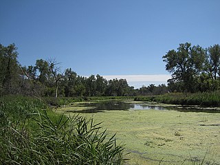
Marais des Cygnes National Wildlife Refuge (NWR) is located in Linn County, Kansas along the Marais des Cygnes River. The 7,500 acre (30 km2) Refuge was established in 1992 to protect one of the northwestern-most examples of bottomland hardwood forest in the United States as well as the largest contiguous tract of bottomland hardwood forest in Kansas. Marais des Cygnes means "marsh of swans" in French.

Kirwin National Wildlife Refuge is a National Wildlife Refuge of the United States located in Kansas. It was established in 1954 for the conservation and management of wildlife resources, particularly migratory birds. The Kirwin Dam was built in the early 1950s near Kirwin, Kansas, and the reservoir created in the process provides water to the refuge.

Don Edwards San Francisco Bay National Wildlife Refuge (DESFBNWR) is a United States National Wildlife Refuge located in the southern part of San Francisco Bay, California. The Refuge headquarters and visitor center is located in the Baylands district of Fremont, next to Coyote Hills Regional Park, in Alameda County. The visitor center is on Marshlands Rd, off Thornton Ave.

The Neal Smith National Wildlife Refuge is a federal national wildlife refuge located in Jasper County, Iowa, United States. The refuge, formerly known as Walnut Creek, is named after Congressman Neal Edward Smith, who championed its creation. It seeks to restore the tallgrass prairie and oak savanna ecosystems that once covered most of Iowa. It has a herd of approximately 50 buffalo (bison) and 20 elk.

Baskett Slough National Wildlife Refuge is located in northwestern Oregon, 10 miles (16 km) west of Salem in Polk County. Situated in open farmland near the eastern foothills of the Oregon Coast Range with the broad Willamette Valley and the Cascade Range to the east, elevations range from 185 to 414 feet MSL. The Willamette Valley, with its mild, rainy winter climate, is an ideal environment for wintering waterfowl. The valley was once a rich mix of wildlife habitats with extensive wetlands, meandering stream channels and vast seasonal marshes. Today, the valley is a mix of farmland and growing cities, with few areas remaining for wildlife. The Refuge consists of 1,173 acres (4.75 km²) of cropland, which provide forage for wintering geese, 300 acres (1.2 km²) of forests, 550 acres (2.2 km²) of grasslands, and 500 acres (2.0 km²) of shallow water seasonal wetlands and 35 acres (0.14 km²) of permanent open water. In 1965, Baskett Slough National Wildlife Refuge was created to help ensure some of the original habitat remained for species preservation. The refuge is managed by the U.S. Fish and Wildlife Service, an agency of the U.S. Department of the Interior.

The Rydell National Wildlife Refuge is an 2,120-acre (9 km2) National Wildlife Refuge in northwestern Minnesota, located in Woodside Township, Polk County, just west of Erskine in northwestern Minnesota. It was established in 1992, and receives more than 7,800 visitors each year. The refuge is a combination of maple/basswood/oak forest, wetlands, tallgrass prairie and bogs.

Glacial Ridge National Wildlife Refuge was created on October 12, 2004, the 545th National Wildlife Refuge in the United States. Its creation was the result of cooperation between at least 30 agencies or governmental entities. The creation of the refuge was spearheaded by The Nature Conservancy, and the initial endowment of 2,300 acres (9.3 km2) of land was donated by the Conservancy. In light of its planned final size of 37,756 acres (153 km2), it is described by the US Fish and Wildlife Service as "the largest tallgrass prairie and wetland restoration project in U.S. history."
D'Arbonne National Wildlife Refuge is a National Wildlife Refuge of the United States located north of West Monroe, Louisiana. It is in Ouachita and Union Parishes on either side of Bayou D'Arbonne near its confluence with the Ouachita River. It lies on the western edge of the Mississippi River alluvial valley. It was established in 1975 to protect bottomland hardwoods and provide wintering habitat for migratory waterfowl. D'Arbonne is one of four refuges managed in the North Louisiana Refuges Complex.

Straddling the headwaters of the Minnesota River in extreme west-central Minnesota, Big Stone National Wildlife Refuge is within the heart of the tallgrass prairie's historic range. Today, less than one-percent of tallgrass prairie remains.
Crane Meadows National Wildlife Refuge was established in 1992 to preserve a large, natural wetland complex. The refuge is located in central Minnesota and serves as an important stop for many species of migrating birds. Located within a large watershed that includes Rice, Skunk and Mud Lakes, Platte and Skunk Rivers, Rice and Buckman Creeks, and sedge meadow wetlands, it harbors one of the largest nesting populations of greater sandhill cranes in Minnesota. Habitats include native tallgrass prairie, oak savanna, and wetlands with stands of wild rice. With a total authorized acquisition boundary of 13,540 acres (54.8 km2) encompassing this important wetland complex and adjacent uplands, Crane Meadows National Wildlife Refuge presently exists as scattered parcels totaling about 2,000 acres (8.1 km2). Existing ownership lies in Little Falls Township and Agram Township in Morrison County.

Hamden Slough National Wildlife Refuge is a National Wildlife Refuge of the United States in Minnesota. Eastern hardwood forests stretching from the Atlantic seaboard give way to the western prairie at the area, in Audubon Township, near Audubon, Minnesota. Prior to settlement, its diverse vegetation was attractive to wildlife: waterfowl, upland birds, bison, wolves, and other prairie wildlife. When fully restored, the refuge will provide the largest contiguous block of wetland prairie habitat in the region, encompassing nearly 6,000 acres (24 km2).
Northern Tallgrass Prairie National Wildlife Refuge was established to provide a means of working with individuals, groups, private organizations, and government entities to permanently preserve a portion of the remaining remnant tracts of northern tallgrass prairie in Minnesota and Iowa. The United States Fish and Wildlife Service is acquiring remnant prairie tracts for the refuge in both easement and fee title interests from willing sellers.
Tamarac National Wildlife Refuge is a National Wildlife Refuge of the United States. It lies in the glacial lake country of northwestern Minnesota in Becker County, 18 miles (29 km) northeast of Detroit Lakes. It was established in 1938 as a refuge breeding ground for migratory birds and other wildlife. It covers 42,724 acres (172.90 km2).
Panther Swamp National Wildlife Refuge is one of seven refuges in the Theodore Roosevelt National Wildlife Refuge Complex in Mississippi. Established in 1978, Panther Swamp National Wildlife Refuge encompasses 38,697 acres (156.60 km2). Included in those acres is one of the largest blocks of bottomland forest in the lower Mississippi River alluvial floodplain. The upland areas or ridges often crest at no more than one foot above swamp areas, and contain nuttall, willow and water oaks and other species while overcup oak, bitter pecan and ash dominate the transition zone from swamp to upland. Additional habitat types consist of reforested and agricultural areas.

Waubay National Wildlife Refuge is a National Wildlife Refuge in South Dakota. "Waubay" means "a place where numbers of birds make their nests" in the Dakota language. The Refuge encompasses 4,650 acres (18.8 km2) of wetlands, native tallgrass prairie, and bur oak forest that provide a wide variety of nesting habitat for more than 100 species of waterfowl, song birds, and upland game birds as well as 140 additional bird species during migrations. Mammals include species from the ever-present white-tailed deer to the more elusive coyote and the diminutive pygmy shrew. The central location of Waubay National Wildlife Refuge in North America gives visitors the chance to see a mix of eastern, western, northern, and southern species.

The Umatilla National Wildlife Refuge is located on and around the Columbia River about 15 miles (24 km) northwest of Hermiston, Oregon and includes 8,907 acres (3,605 ha) in Oregon, and 14,876 acres (6,020 ha) in Washington. It was established in 1969 to help mitigate habitat lose due to the flooding that occurred following the construction of the John Day Dam. The refuge is popular with birdwatchers and wildlife enthusiasts.

Tewaukon National Wildlife Refuge is located in southeastern North Dakota along the western edge of the northern tallgrass prairie, about 5 miles (8.0 km) south of Cayuga, in Sargent County. The Wild Rice River flows through the Refuge and then into Lake Tewaukon. Established in 1945, the 8,363-acre (33.84 km2) Refuge is located in the Prairie Pothole Region, one of the most biologically productive areas on earth.

Tijuana Slough National Wildlife Refuge is located in the most southwestern corner of the contiguous United States. It is part of the San Diego National Wildlife Refuge Complex. It was established in 1980.
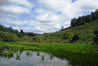
The Ellicott Slough National Wildlife Refuge is a United States National Wildlife Refuge located in the northern part of the Monterey Bay area of California.

The Windom Wetland Management District acquires and manages Waterfowl Production Areas, enforces wetland easements, and provides conservation assistance to landowners in 12 southwestern Minnesota counties. The landscape is dominated by intense, row-crop agriculture, which has led to the drainage of most wetlands and widespread water quality problems. Deteriorating drainage tile systems and the abundance of historic wetland basins provide unlimited opportunities for wetland restorations.