
Quivira National Wildlife Refuge is located in south central Kansas near the town of Stafford. It lies mostly in northeastern Stafford County, but small parts extend into southwestern Rice and northwestern Reno Counties. Its proximity to the Central Flyway migration route and the salt marshes on the refuge combine to endow the refuge with a large variety of birds. Many of these birds are uncommon in other parts of Kansas or even the central part of the continent.

The tallgrass prairie is an ecosystem native to central North America. Historically, natural and anthropogenic fire, as well as grazing by large mammals provided periodic disturbances to these ecosystems, limiting the encroachment of trees, recycling soil nutrients, and facilitating seed dispersal and germination. Prior to widespread use of the steel plow, which enabled large scale conversion to agricultural land use, tallgrass prairies extended throughout the American Midwest and smaller portions of southern central Canada, from the transitional ecotones out of eastern North American forests, west to a climatic threshold based on precipitation and soils, to the southern reaches of the Flint Hills in Oklahoma, to a transition into forest in Manitoba.

An oak savanna is a type of savanna—or lightly forested grassland—where oaks are the dominant trees. The terms "oakery" or "woodlands" are also used commonly, though the former is more prevalent when referencing the Mediterranean area. These savannas were maintained historically through wildfires set by lightning, humans, grazing, low precipitation, and/or poor soil.

Attwater Prairie Chicken National Wildlife Refuge is a federally protected refugium encompassing one of the largest remnants of coastal prairie habitat remaining in southeast Texas, United States, and home to one of the last populations of critically endangered Attwater's prairie chickens, a ground-dwelling grouse of the coastal prairie ecosystem.

The Niobrara National Scenic River is in north-central Nebraska, United States, approximately 300 miles (480 km) northwest of Omaha. In 1991, Congress set aside 76 miles (120 km) for preservation under the management of the National Park Service with assistance from the local Niobrara Council. Several "outstandingly remarkable values" have been designated to be protected along the Niobrara National Scenic River, including: Fish and Wildlife, Scenery, Fossil Resources, Geology, and Recreation. The river was designated by Backpacker magazine as one of the 10 best rivers for canoeing in the United States.

Driftless Area National Wildlife Refuge is a United States National Wildlife Refuge in northeastern Iowa, southwestern Wisconsin and northwestern Illinois. It is a non-contiguous collection of parcels in the vicinity of the Upper Mississippi River National Wildlife and Fish Refuge.

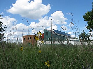
The Neal Smith National Wildlife Refuge is a federal national wildlife refuge located in Jasper County, Iowa, United States. The refuge, formerly known as Walnut Creek, is named after Congressman Neal Edward Smith, who championed its creation. It seeks to restore the tallgrass prairie and oak savanna ecosystems that once covered most of Iowa. It has a herd of approximately 50 American bison and 20 elk. An initial group of six bison were released in 1996.
The Minnesota Valley National Wildlife Refuge is a 14,000-acre (5,666 ha) National Wildlife Refuge in eastern and central Minnesota. Located just south of the city of Minneapolis, it is one of fourteen Regional Priority Urban Wildlife Refuges in the nation. Many parts of the Refuge are near large establishments of the Twin Cities; the Bloomington Education and Visitor Center and two trailheads are located just blocks from the Mall of America, the Wilkie Unit is just east of Valleyfair and the Louisville Swamp Unit is just south of Minnesota Renaissance Festival.

Glacial Ridge National Wildlife Refuge was created on October 12, 2004, the 545th National Wildlife Refuge in the United States. Its creation was the result of cooperation between at least 30 agencies or governmental entities. The creation of the refuge was spearheaded by The Nature Conservancy, and the initial endowment of 2,300 acres (9.3 km2) of land was donated by the Conservancy. In light of its planned final size of 37,756 acres (153 km2), it is described by the US Fish and Wildlife Service as "the largest tallgrass prairie and wetland restoration project in U.S. history."
Union Slough National Wildlife Refuge, located in Kossuth County, Iowa, was established in 1938 to provide a refuge and breeding ground for waterfowl and other migratory birds. The actual slough is all that remains of a pre-glacial riverbed, and its name is derived from the connection or "union" of two watersheds: the Blue Earth River of Minnesota and the East Fork of the Des Moines River. The terrain is nearly flat, allowing the flow of the water to be determined by the direction of the wind at times.

Straddling the headwaters of the Minnesota River in west-central Minnesota, Big Stone National Wildlife Refuge is within the heart of the tallgrass prairie's historic range. Today, less than one-percent of tallgrass prairie remains.
Crane Meadows National Wildlife Refuge was established in 1992 to preserve a large, natural wetland complex. The refuge is located in central Minnesota and serves as an important stop for many species of migrating birds. Located within a large watershed that includes Rice, Skunk and Mud Lakes, Platte and Skunk Rivers, Rice and Buckman Creeks, and sedge meadow wetlands, it harbors one of the largest nesting populations of greater sandhill cranes in Minnesota. Habitats include native tallgrass prairie, oak savanna, and wetlands with stands of wild rice. With a total authorized acquisition boundary of 13,540 acres (54.8 km2) encompassing this important wetland complex and adjacent uplands, Crane Meadows National Wildlife Refuge presently exists as scattered parcels totaling about 2,000 acres (8.1 km2). Existing ownership lies in Little Falls Township and Agram Township in Morrison County.

Hamden Slough National Wildlife Refuge is a National Wildlife Refuge of the United States in Minnesota. Eastern hardwood forests stretching from the Atlantic seaboard give way to the western prairie at the area, in Audubon Township, near Audubon, Minnesota. Prior to settlement, its diverse vegetation was attractive to wildlife: waterfowl, upland birds, bison, wolves, and other prairie wildlife. When fully restored, the refuge will provide the largest contiguous block of wetland prairie habitat in the region, encompassing nearly 6,000 acres (24 km2).

Tewaukon National Wildlife Refuge is located in southeastern North Dakota along the western edge of the northern tallgrass prairie, about 5 miles (8.0 km) south of Cayuga, in Sargent County. The Wild Rice River flows through the Refuge and then into Lake Tewaukon. Established in 1945, the 8,363-acre (33.84 km2) Refuge is located in the Prairie Pothole Region, one of the most biologically productive areas on earth. It lies within the Tewaukon Wetland Management District.
Big Stone Wetland Management District is a protected area encompassing scattered wetlands in Lincoln and Lyon Counties, Minnesota, United States. It is operated by the U.S. Fish and Wildlife Service out of headquarters within Big Stone National Wildlife Refuge. District staff also serve private land resource interests by providing technical assistance for United States Department of Agriculture programs and restoring wetlands on private lands.
Detroit Lakes Wetland Management District is located in northwest Minnesota and includes the counties of Becker, Clay, Mahnomen, Norman, and Polk - an area of approximately 6,000 square miles (16,000 km2). The district is divided into three general landscape areas, roughly equal in size. From west to east, these are: the Red River Valley floodplain, the glacial moraine/prairie pothole region, and the hardwood/coniferous forest. The district currently manages over 42,000 acres (170 km2) of public land in 165 waterfowl production areas (WPAs). Additionally, district staff are responsible for more than 300 wetland and upland easements on private property, totaling more than 11,000 acres (45 km2).

The Windom Wetland Management District acquires and manages Waterfowl Production Areas, enforces wetland easements, and provides conservation assistance to landowners in 12 southwestern Minnesota counties. The landscape is dominated by intense, row-crop agriculture, which has led to the drainage of most wetlands and widespread water quality problems. Deteriorating drainage tile systems and the abundance of historic wetland basins provide unlimited opportunities for wetland restorations.
The Hayden Prairie State Preserve is a 240-acre (97 ha) tallgrass prairie located in Howard County, Iowa. It is a National Natural Landmark managed by the Iowa Department of Natural Resources. Located close to the northern border of the state of Iowa, the nearest towns are Chester and Lime Springs.

The Central tall grasslands are a prairie ecoregion of the Midwestern United States, part of the North American Great Plains.
Tallgrass most frequently refers to the native North American grasslands Tallgrass prairie.
