Buffalo River State Park (Minnesota)

Last updated

Buffalo River State Park
Buffalo River State Park trail.JPG
Native prairie in Buffalo River State Park
USA Minnesota relief location map.svg
Red pog.svg
Location of Buffalo River State Park in Minnesota
Usa edcp relief location map.png
Red pog.svg
Buffalo River State Park (Minnesota) (the United States)
Location Clay, Minnesota, United States
Coordinates 46°51′53″N96°27′36″W / 46.86472°N 96.46000°W / 46.86472; -96.46000
Area1,068 acres (4.32 km2)
Elevation981 ft (299 m) [1]
Established1937
Named forthe Buffalo River
Governing bodyMinnesota Department of Natural Resources
Buffalo River State Park WPA/Rustic Style Historic Resources
Buffalo River SP storm shelter.jpg
One of the district's six contributing properties, a 1938 latrine
LocationOff US 10, Riverton Township
Area19 acres (7.7 ha)
Built1937–1940
ArchitectO. Newstrom
Architectural style National Park Service rustic
MPS Minnesota State Park CCC/WPA/Rustic Style MPS
NRHP reference No. 89001671
Added to NRHPOctober 25, 1989
Template:Attached KML/Buffalo River State Park (Minnesota)
KML is from Wikidata

Buffalo River State Park is a state park of Minnesota, United States, conserving a prairie bisected by the wooded banks of the Buffalo River. Together with the adjacent Bluestem Prairie Scientific and Natural Area co-owned by The Nature Conservancy and Minnesota's Department of Natural Resources, it protects one of the largest and highest-quality prairie remnants in Minnesota. [2] It used to offer a man-made swimming pond close to the Fargo–Moorhead metropolitan area, however, that has not been open since 2018. Presently, it is most popular for its high quality educational programming, swimming in the Buffalo River, and picnicking. [3] The 1,068-acre (432 ha) park is located just off U.S. Route 10 in Clay County, 4.5 miles (7.2 km) east of Glyndon and 14 miles (23 km) east of Moorhead. [4]

Contents

Buffalo River State Park was established in 1937 and developed by the Works Progress Administration. Three buildings and three structures built in the National Park Service rustic style were added to the National Register of Historic Places in 1989. The park was originally focused on providing outdoor recreation amenities like a man-made swimming pond since there were few other opportunities in the area. [5] It was expanded beginning in the 1960s as the quality and rarity of the surrounding prairie were recognized. [6]

The 6,078-acre (2,460 ha) Scientific and Natural Area (SNA) section is used for environmental education by local schools and regional colleges and universities. It is also a destination for viewing the spring courtship ritual of the greater prairie chicken. [7]

Natural history

Geology

The topography of Buffalo River/Bluestem Prairie largely formed beneath a proglacial lake at the end of the last glacial period. The region had previously been covered and exposed many times by successive glaciations. As the ice of the Wisconsin glaciation melted, the Red River Valley was covered by Glacial Lake Agassiz 10,000–8,000 years ago. [3] Fine sediments formed a level lakebed. However beach ridges of sand and gravel formed in various places as the shorelines shifted. [4] There is a beach ridge on the east edge of the state park called Campbell Ridge, and another to the southeast in the SNA called Norcross Ridge. The bedrock—a thin layer of shale over granite, slate, and schist—lies beneath 250–500 feet (76–152 m) of silt deposited by Lake Agassiz. The lake finally drained away to the north, leaving behind a distinctly flat plain with very rich soil. [3]

Today the park slopes slightly westward, dropping 100 feet (30 m) in elevation from its eastern border to its western border. The fairly flat prairie is interrupted by the two sandy beach ridges and associated rolling hills. Where it crosses the ridges the Buffalo River has formed steep and unstable cut banks up to 30 feet (9.1 m) high. A few glacial erratics stud the prairie. [3]

Flora

The Buffalo River and Bluestem prairies preserve one of the largest remnants of northern tall grasslands, an ecoregion largely confined to the Red River Valley. The prairie is of high quality, much of it never having been cultivated. [7] It is characterized by big bluestem and little bluestem interspersed with forbs like coneflowers, blazing star, and prairie clover. [3] Some 250 species of wildflowers and grasses have been cataloged in the park. [4] Rare plants include sticky false-asphodel, small white lady's slipper, northern gentian, plains reedgrass, blanket flower, and the endangered western prairie fringed orchid. [7] Yuccas and cacti can be found at the south end of the property. [3]

A gallery forest extends across the prairie on either side of the Buffalo River. It is characterized by elm, ash, cottonwood, oak, and basswood. [2] The understory comprises young basswood, ash, and elm along with boxelder, hazel, and gooseberry. The drier soil along the lip of the riverbank supports bur oak. Patches of willow, aspen, and boxelder occur on the prairie in spots with poor drainage. [3]

Fauna

200 species of bird and 40 species of mammal have been documented in Buffalo River State Park. Mammals include moose, white-tailed deer, coyotes, red foxes, badgers, white-tailed jackrabbits, beavers, plains pocket mice, and northern grasshopper mice. [2] Several uncommon prairie birds find refuge in the park, including greater prairie chickens, marbled godwits, and upland sandpipers. [2] Also present are sandhill cranes, loggerhead shrikes, and Henslow's sparrows. [7] Other vertebrates include the Great Plains toad and western hognose snake. [3] [7] Three rare butterflies have been documented in the prairie: the Regal Fritillary, Poweshiek skipper, and Dakota skipper. [7]

Cultural history

Native American history

American bison reliably wintered on the site of the future park, prompting Ojibwe people to call a stream Pijijiwizbi, meaning "Buffalo River." Although this originally referred only to a tributary of the modern Buffalo River, settlers misapplied the name to the larger waterway. [4] Far back into prehistory, Native Americans commonly used the river and beach ridges as travel corridors. The Minnesota Historical Society has postulated that the park is likely to contain archaeological resources, but little research has been done. [3]

Settlement

Euro-Americans arrived in the 1820s and recognized the fertile prairie soil as ideal farmland. A leg of the Red River Trails followed the ancient route along Campbell Ridge in the vicinity of the park. Bowing to mounting pressures against their traditional lifestyle, the local Ojibwe ceded the region to the United States in their 1855 Treaty of Washington. [4]

In 1864 work began on the Northern Pacific Railway across the northern United States. Rail access brought homesteaders to the area in the 1870s. In 1875 J.H Smyser, who'd served as a captain in the Union Army during the American Civil War, purchased much of the future park property for a horse and cattle ranch. His impressive 1875 manor stood on the grounds for many years but burned down in 1959. [4] Most of the land was used for pasture and hayfields rather than crop farming, which had the effect of preserving more of the native species. [3]

To reduce a taxing gradient for their trains, Northern Pacific in 1906 began building the massive embankment that still marks the park's northern border. [4]

Park creation and development

Invisible Square.svg
Mapscaleline.svg
1km
0.6miles
Red pog.svg
B U F F A L O  R I V E R
S T A T E  P A R K
Buffalo River State Park (Minnesota)
Buffalo River State Park

Buffalo River State Park was created in the late 1930s, taking advantage of federal job creation programs during the Great Depression. The Moorhead Rod and Gun Club championed the site and the Minnesota Legislature officially added it to the state park system in 1937. [6] At the time it was the only state-owned recreational facility in the region. [5] The Works Progress Administration (WPA) established a camp and began developing the park's original 122 acres (49 ha). WPA workmen established infrastructures like the swimming area, entrance road, parking area, water supply, and toilets. [6] They also built a bathhouse, a latrine, and a diversion dam in the National Park Service rustic style using split stone and logs. [5]

The original boundaries of the park were drawn with an emphasis on recreation. [5] As recognition grew of the size and quality of the surrounding prairie, the park was expanded in the 1960s. The Nature Conservancy purchased additional land south of the park beginning in 1975. [7] The Nature Conservancy's property lies partly within the state park's official boundaries and partly without. [3]

In 1989 the park's WPA developments were listed on the National Register of Historic Places as a 19-acre (7.7 ha) historic district. The district comprises six contributing properties—three buildings and three structures. The buildings consist of a 1938 latrine, the 1940 bath house, and a 1940 garage/residence, only the former bath house is still available for public use. The structures consist of a 1938 diversion dam on the Buffalo River, the 1940 swimming beach (closed since 2018), and some 1940 stone curbs in the parking lot. The district boundary includes a well house constructed in the 1960s, which is non-contributing. The contributing properties are considered historically significant for their association with the Great Depression and the resulting federal work relief programs of the New Deal, and with the early development of Minnesota's state parks. They were also recognized for their finely crafted and labor-intensive split stone architecture. [8]

Recreation

Buffalo River State Park's swimming pool and bath house Buffalo River State Park swimming pool.JPG
Buffalo River State Park's swimming pool and bath house

Buffalo River State Park sees high local use, particularly for its connection to the Pine to Prairie Birding route. Overnight visitors, conversely, are often far from home and using the park as a stopover on the way to a farther destination. Many campers come from Canada or the Dakotas. [3] The campground has 44 sites—35 with electric hookups—plus showers, flush toilets, and a dump station. A separate group camp accommodates up to 50 people. [2] The campground, picnic area, and swimming pool are located in the shade of the forest. [4]

The man-made swimming pond featured a sand bottom, filtered water, lifeguards, accessible features, and was surrounded by an artificial beach. Again, this feature has not been open since 2018 due to lifeguard shortages in the region and needed repairs. The Buffalo River provides fishing opportunities. [2]

View of the Buffalo River from hiking trail. Buffalo River State Park- Minnesota.jpg
View of the Buffalo River from hiking trail.

There are 12 miles (19 km) of hiking trails, 6 miles (9.7 km) of which are groomed for cross-country skiing in winter. The rest of the park is open to snowshoers. [2] In March and April The Nature Conservancy operates two viewing blinds from which visitors can observe the dramatic lek mating ritual of the greater prairie chicken. [9]

Related Research Articles

<span class="mw-page-title-main">Tallgrass prairie</span> Ecosystem native to central North America

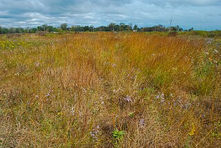
The tallgrass prairie is an ecosystem native to central North America. Historically, natural and anthropogenic fire, as well as grazing by large mammals provided periodic disturbances to these ecosystems, limiting the encroachment of trees, recycling soil nutrients, and facilitating seed dispersal and germination. Prior to widespread use of the steel plow, which enabled large scale conversion to agricultural land use, tallgrass prairies extended throughout the American Midwest and smaller portions of southern central Canada, from the transitional ecotones out of eastern North American forests, west to a climatic threshold based on precipitation and soils, to the southern reaches of the Flint Hills in Oklahoma, to a transition into forest in Manitoba.

<span class="mw-page-title-main">Driftless Area</span> Geological region in the Midwestern US

The Driftless Area, also known as Bluff Country and the Paleozoic Plateau, is a topographical and cultural region in the Midwestern United States that comprises southwestern Wisconsin, southeastern Minnesota, northeastern Iowa, and the extreme northwestern corner of Illinois. The Driftless Area is a USDA Level III Ecoregion: Ecoregion 52. The Driftless Area takes up a large portion of the Upper Midwest forest–savanna transition. The Blufflands refers to the eastern section of the Driftless area in Minnesota, due to the steep bluffs and cliffs around the river valleys. The western half is known as the Rochester Plateau, which is flatter than the Blufflands. The Coulee Region refers to the southwestern part of the Driftless Area in Wisconsin. It is named for its numerous ravines.

<span class="mw-page-title-main">Jeffers Petroglyphs</span> United States historic place

The Jeffers Petroglyphs site is an outcrop in southwestern Minnesota with pre-contact Native American petroglyphs. The petroglyphs are pecked into rock of the Red Rock Ridge, a 23-mile (37 km)-long Sioux quartzite outcrop that extends from Watonwan County, Minnesota to Brown County, Minnesota. The exposed surface is approximately 150 by 650 feet and surrounded by virgin prairie. "The site lies in an area inhabited in the early historic period by the Dakota Indians, and both the style and form of some of the carvings are identical with motifs that appear on Dakota hide paintings and their quill designs and beadwork. Others are foreign to this Plains Indian tradition and seem to be much earlier in origin." Several old wagon trail ruts traverse the site, one of which is believed to be the old stage coach route from New Ulm, Minnesota to Sioux Falls, South Dakota.

<span class="mw-page-title-main">Whitewater State Park</span> United States historic place

Whitewater State Park is a state park of Minnesota, United States, preserving a stretch of the Whitewater River surrounded by rocky bluffs. It is located in Winona County in the southeastern blufflands area of the state. The 2,700-acre (11 km2) park features scenic overlooks and trout fishing in the spring-fed Whitewater River and Trout Run Creek. It has about 300,000 visitors annually, and is located 7 miles (11 km) north of St. Charles on Minnesota State Highway 74, which runs through the park.

<span class="mw-page-title-main">Wild River State Park</span> State park in Minnesota, United States

Wild River State Park is a state park of Minnesota, United States, curving along 18 miles (29 km) of the St. Croix River. This long, narrow park is shaped somewhat like a sideways 'S', with development largely concentrated in the lower third. The remote upper sections flank the mouth of a tributary called the Sunrise River. The park is managed to provide quieter, more nature-oriented recreation as a counterpoint to the busier William O'Brien and Interstate State Parks downstream.

<span class="mw-page-title-main">Interstate Park</span> United States historic place

Interstate Park comprises two adjacent state parks on the Minnesota–Wisconsin border, both named Interstate State Park. They straddle the Dalles of the St. Croix River, a deep basalt gorge with glacial potholes and other rock formations. The Wisconsin park is 1,330 acres (538 ha) and the Minnesota park is 298 acres (121 ha). The towns of Taylors Falls, Minnesota and St. Croix Falls, Wisconsin are adjacent to the park. Interstate Park is within the Saint Croix National Scenic Riverway and the Ice Age National Scientific Reserve. The western terminus of the Ice Age National Scenic Trail is on the Wisconsin side. On the Minnesota side, two areas contain National Park Service rustic style buildings and structures that are listed on the National Register of Historic Places.

<span class="mw-page-title-main">Minneopa State Park</span> United States historic place

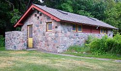
Minneopa State Park is a state park in the U.S. state of Minnesota. It was established in 1905 to preserve Minneopa Falls, a large waterfall for southern Minnesota, and was expanded in the 1960s to include the lower reaches of Minneopa Creek and a large tract of prairie. Minneopa is Minnesota's third oldest state park, after Itasca and Interstate. Two park resources are listed on the National Register of Historic Places: the 1862 Seppman Mill and a district of seven Rustic Style structures built by the Works Progress Administration in the late 1930s. The park is located almost entirely on the south side of the Minnesota River, three miles (4.8 km) west of Mankato. In 2015 the state reintroduced American bison to the park in a 330-acre (130 ha) fenced enclosure, through which visitors can drive in their vehicles.

<span class="mw-page-title-main">Charles A. Lindbergh State Park</span> Protected area in Minnesota, United States

Charles A. Lindbergh State Park is a 569-acre (2.3 km2) Minnesota state park on the outskirts of Little Falls. The park was once the farm of Congressman Charles August Lindbergh and his son Charles Lindbergh, the famous aviator. Their restored 1906 house and two other farm buildings are within the park boundaries. The house, a National Historic Landmark, and an adjacent museum are operated by the Minnesota Historical Society, known as the Charles Lindbergh House and Museum. Three buildings and three structures built by the Works Progress Administration in the 1930s were named to the National Register of Historic Places. These buildings include a picnic shelter and a water tower, built in the Rustic Style from local stone and logs, and have remained relatively unchanged since construction. Although the property includes shoreline on the Mississippi River, the Lindbergh family requested that the park not include intensive use areas for swimming or camping, so development was kept to a minimum.

<span class="mw-page-title-main">Blue Mounds State Park</span> State park in Minnesota, United States

Blue Mounds State Park is a state park in Rock County, Minnesota, United States, near the town of Luverne. It protects an American bison herd which grazes on one of the state's largest prairie remnants.

<span class="mw-page-title-main">Camden State Park</span> United States historic place

Camden State Park is a state park on the Redwood River in southwestern Minnesota near Marshall. It is used for picnics, camping, hiking, and other outdoor recreation.

<span class="mw-page-title-main">Judge C. R. Magney State Park</span> State park in Minnesota, United States

Judge C. R. Magney State Park is a state park in the U.S. state of Minnesota, on the North Shore of Lake Superior. It was named for Clarence R. Magney, a former mayor of Duluth and justice of the Minnesota Supreme Court, who was instrumental in getting 11 state parks and scenic waysides established along the North Shore. The park is best known for the Devil's Kettle, an unusual waterfall and rock formation in which half of the Brule River disappears into a pothole.

<span class="mw-page-title-main">Glacial Lakes State Park</span> State park in Minnesota, United States

Glacial Lakes State Park is a state park of Minnesota, USA, approximately 5 miles (8.0 km) south of Starbuck. It was founded in 1963 to preserve some of the remaining rolling prairie which previously covered much of the state. Located in the Leaf Mountains, the park and the area around it contains many glacial landforms created by the Wisconsonian glaciation.

<span class="mw-page-title-main">Flandrau State Park</span> United States historic place

Flandrau State Park is a state park of Minnesota, United States, on the Cottonwood River adjacent to the city of New Ulm. Initially called Cottonwood River State Park, it was renamed in 1945 to honor Charles Eugene Flandrau, a leading citizen of early Minnesota who commanded defenses during the Battles of New Ulm in the Dakota War of 1862. The park was originally developed in the 1930s as a job creation project to provide a recreational reservoir. However the dam was repeatedly damaged by floods and was removed in 1995.

<span class="mw-page-title-main">Glendalough State Park</span> State park in Minnesota, United States

Glendalough State Park is a state park of Minnesota, USA, in Otter Tail County near Battle Lake close to Minnesota State Highway 78. It is named after Glendalough in Ireland. The park was once used as a resort and game farm by the owners of Cowles Media Company, owner of what is today the Star Tribune newspaper. The park contains 1,931 acres (7.81 km2) on land and 1,000 acres (4.0 km2) on the water. Cowles Media Company transferred title to Glendalough to the Nature Conservancy in 1990, and the Nature Conservancy transferred title to the State of Minnesota in 1992. Glendalough was officially declared a state park with a celebration on Earth Day, April 22, 1992.

<span class="mw-page-title-main">Lake Shetek State Park</span> United States historic place

Lake Shetek State Park is a state park of Minnesota, United States, on Lake Shetek, which is the largest lake in southwestern Minnesota and the headwaters of the Des Moines River. It is most popular for water recreation and camping. However the park also contains historical resources related to the Dakota War of 1862, including an original log cabin and a monument to 15 white settlers killed there and at nearby Slaughter Slough on August 20, 1862.

<span class="mw-page-title-main">Geology of Minnesota</span> Overview of the geology of the U.S. state of Minnesota

The geology of Minnesota comprises the rock, minerals, and soils of the U.S. state of Minnesota, including their formation, development, distribution, and condition.

<span class="mw-page-title-main">Buffalo Ridge</span> Range of hills in Minnesota, US

Buffalo Ridge is a large expanse of rolling hills in the southeastern part of the larger Coteau des Prairies. It stands 1,995 feet (608 m) above sea level. The Buffalo Ridge is sixty miles (97 km) long and runs through Lincoln, Pipestone, Murray, Nobles, and Rock counties in the southwest corner of Minnesota, and Minnehaha, Moody, and Lincoln counties in southeast South Dakota.

<span class="mw-page-title-main">Glacial Ridge National Wildlife Refuge</span> National wildlife refuge in Minnesota, United States

Glacial Ridge National Wildlife Refuge was created on October 12, 2004, the 545th National Wildlife Refuge in the United States. Its creation was the result of cooperation between at least 30 agencies or governmental entities. The creation of the refuge was spearheaded by The Nature Conservancy, and the initial endowment of 2,300 acres (9.3 km2) of land was donated by the Conservancy. In light of its planned final size of 37,756 acres (153 km2), it is described by the US Fish and Wildlife Service as "the largest tallgrass prairie and wetland restoration project in U.S. history."

<span class="mw-page-title-main">Chiwaukee Prairie</span> Prairie in Wisconsin, United States

Chiwaukee Prairie is a 485-acre (1.96 km2) prairie in Pleasant Prairie, Wisconsin managed by the Wisconsin Department of Natural Resources. It is located on Lake Michigan at the Illinois state line and includes grassy wetlands, wooded areas, and the Kenosha Sand Dunes at its northern tip. It is home to an abundance of wildlife. It was designated a Wisconsin State Natural Area in 1967 and a National Natural Landmark in 1973.

References

  1. "Buffalo River Park". Geographic Names Information System . United States Geological Survey. January 11, 1980. Retrieved November 2, 2012.
  2. 1 2 3 4 5 6 7 "Buffalo River State Park". Minnesota Department of Natural Resources. Retrieved November 2, 2012.
  3. 1 2 3 4 5 6 7 8 9 10 11 12 "A Management Plan for Buffalo River State Park". Minnesota Department of Natural Resources. 1980.{{cite journal}}: Cite journal requires |journal= (help)
  4. 1 2 3 4 5 6 7 8 "Buffalo River State Park" (PDF). Minnesota Department of Natural Resources. December 2008. Archived from the original (PDF) on May 14, 2013. Retrieved November 2, 2012.{{cite journal}}: Cite journal requires |journal= (help)
  5. 1 2 3 4 "Buffalo River State Park". Rustic Style Resources in Minnesota State Parks. Minnesota Historical Society. Retrieved November 2, 2012.
  6. 1 2 3 Meyer, Roy W. (1991). Everyone's Country Estate: A History of Minnesota's State Parks. St. Paul, Minn.: Minnesota Historical Society Press. ISBN   0-8735-1266-9.
  7. 1 2 3 4 5 6 7 "Bluestem Prairie Scientific and Natural Area". The Nature Conservancy. Retrieved November 22, 2012.
  8. Anderson, Rolf T. (August 25, 1988). "National Register of Historic Places Registration Form: Buffalo River State Park WPA/Rustic Style Historic Resources". National Park Service. Retrieved August 4, 2020.{{cite journal}}: Cite journal requires |journal= (help)
  9. "Bluestem Prairie Scientific and Natural Area Bird Checklist" (PDF). Minnesota Department of Natural Resources. 2008. Retrieved November 30, 2012.{{cite journal}}: Cite journal requires |journal= (help)