
St. Louis County is a county located in the Arrowhead Region of the U.S. state of Minnesota. As of the 2020 census, the population was 200,231. Its county seat is Duluth. It is the largest county in Minnesota by land area, and the largest in the United States by total area east of the Mississippi River, ahead of Aroostook County, Maine.

Ely is a city in Saint Louis County, Minnesota, United States. The population was 3,460 at the 2010 census. It is on the Vermilion Iron Range, and is historically home to several iron ore mines.

The Boundary Waters Canoe Area Wilderness is a 1,090,000-acre (4,400 km2) wilderness area within the Superior National Forest in northeastern part of the US state of Minnesota under the administration of the U.S. Forest Service. A mixture of forests, glacial lakes, and streams, the BWCAW's preservation as a primitive wilderness began in the 1900s and culminated in the Boundary Waters Canoe Area Wilderness Act of 1978. It is a popular destination for canoeing, hiking, and fishing, and is one of the most visited wildernesses in the United States.

Voyageurs National Park is an American national park in northern Minnesota near the city of International Falls established in 1975. The park's name commemorates the voyageurs—French-Canadian fur traders who were the first European settlers to frequently travel through the area. Notable for its outstanding water resources, the park is popular with canoeists, kayakers, other boaters, and fishermen. The Kabetogama Peninsula, which lies entirely within the park and makes up most of its land area, is accessible only by boat. To the east of the park lies the Boundary Waters Canoe Area Wilderness.
The Boundary Waters, also called the Quetico-Superior Country, is a region of wilderness straddling the Canada–United States border between Ontario and Minnesota, in the area just west of Lake Superior. While "Boundary Waters" is a common name for this region, the two nations also share extensive boundary waters along their border, beyond this region. This region is part of the Superior National Forest in northeastern Minnesota, and in Canada it includes La Verendrye and Quetico Provincial Parks in Ontario. Voyageurs National Park in Minnesota may also be considered part of the Boundary Waters. The name "Boundary Waters" is often used in the U.S. to refer specifically to the U.S. Wilderness Area protecting its southern extent, the Boundary Waters Canoe Area Wilderness.
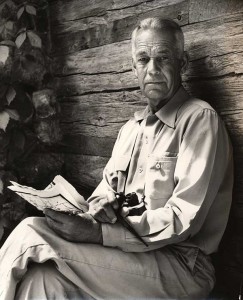
Sigurd Ferdinand Olson was an American author, environmentalist, and advocate for the protection of wilderness. For more than thirty years, he served as a wilderness guide in the lakes and forests of the Quetico-Superior country of northern Minnesota and northwestern Ontario. He was known honorifically as the Bourgeois — a term the voyageurs of old used of their trusted leaders.

Lake Vermilion is a shallow freshwater lake in northeastern Minnesota, United States. The Ojibwe originally called the lake Nee-Man-Nee, which means “the evening sun tinting the water a reddish color”. French fur traders translated this to the Latin word Vermilion, which is a red pigment. Lake Vermilion is located between the towns of Tower on the east and Cook on the west, in the heart of Minnesota's Arrowhead Region at Vermilion Iron Range. The area was mined from the late 19th century until the 1960s, and the Soudan Mine operated just south of the lake.

Rainy Lake is a freshwater lake with a surface area of 360 square miles (932 km2) that straddles the border between the United States and Canada. The Rainy River issues from the west side of the lake and is harnessed to make hydroelectricity for US and Canadian locations. International Falls, Minnesota and the much smaller city of Ranier, Minnesota are situated opposite Fort Frances, Ontario, on either side of the Rainy River. Rainy Lake and Rainy River establish part of the boundary between the US state of Minnesota and the Canadian province of Ontario.

Jay Cooke State Park is a state park of Minnesota, United States, protecting the lower reaches of the Saint Louis River. The park is located about 10 miles (16 km) southwest of Duluth and is one of the ten most visited state parks in Minnesota. The western half of the park contains part of a rocky, 13-mile (21 km) gorge. This was a major barrier to Native Americans and early Europeans traveling by canoe, which they bypassed with the challenging Grand Portage of the St. Louis River. The river was a vital link connecting the Mississippi waterways to the west with the Great Lakes to the east.
Kabetogama is an unincorporated community in Kabetogama Township, Saint Louis County, Minnesota, United States, located within the Kabetogama State Forest.
Crane Lake is an unincorporated community in Crane Lake Township, Saint Louis County, Minnesota, United States; located within the Kabetogama State Forest.
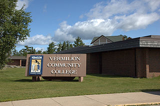
Vermilion Community College is a public community college in Ely, Minnesota. It is adjacent to the Boundary Waters Canoe Area Wilderness and the Superior National Forest and offers several niche programs focusing on natural resources, natural sciences, and outdoor education. Vermilion is also a residential college offering housing to nearly half of all attending students.
The Finland State Forest is a state forest located near the unincorporated community of Finland in Lake and Cook counties, Minnesota. Of the over 30,000 acres (12,000 ha), the Minnesota Department of Natural Resources manages a third of the land. The federal United States Forest Service manages roughly a quarter of the total forest acreage, as its boundary overlaps in part with that of Superior National Forest. The remainder is split between Cook and Lake County agencies, and private landowners.
The Bear Island State Forest is a state forest in Minnesota bordered by the towns of Ely, Babbitt, and Tower in Lake and Saint Louis counties. It is adjacent to the Burntside State Forest and the federally managed Superior National Forest and Boundary Waters Canoe Area Wilderness. It is managed primarily by the Minnesota Department of Natural Resources and the counties.
The Birch Lakes State Forest is a state forest located in Stearns County, Minnesota. One of the smallest Minnesota state forests, it is managed primarily for recreation by the Minnesota Department of Natural Resources. Big Birch Lake, a 2,112 acres (855 ha) sand- and marl-bottomed lake, is accessible from the northeast corner of the forest. The forest is located in a transitory ecotone between the temperate deciduous forest to the northeast and the tallgrass prairie to the southwest, with the rolling terrain characteristic of the glacial activity in the area.
The Bowstring State Forest is a state forest located in Itasca and Cass Counties in Minnesota. It is located entirely within the boundaries of the federally managed Chippewa National Forest, and is managed by the Minnesota Department of Natural Resources.

The Grand Portage State Forest is a state forest located near the community of Hovland in Cook County, in extreme northeastern Minnesota. The forest encloses Judge C. R. Magney State Park, Swamp River Wildlife Management Area, Hovland Woods Scientific and Natural Area, and Spring Beauty Hardwoods Scientific and Natural Area. It borders the Grand Portage Indian Reservation to the east, the Superior National Forest to the west, and Ontario to the north. The forest is named after the Grand Portage, a historic trade route between the Great Lakes and the Northwest.
The Koochiching State Forest is a state forest located near International Falls in Itasca, Koochiching, and Saint Louis counties, Minnesota. The forest borders the Pine Island State Forest to the west, the Big Fork State Forest and George Washington State Forest to the south, the Nett Lake Indian Reservation and the Kabetogama State Forest to the east. A leg of the forest touches Rainy Lake to the north, which forms part of the international border with Ontario. Of the 565,500 acres (2,288 km2), 344,300 acres (1,393 km2) are managed by the Minnesota Department of Natural Resources, making it one of the largest forests in the Minnesota state system.
The Lake Isabella State Forest is a state forest located in Lake County, Minnesota. The forest is located completely within the Superior National Forest and the Boundary Waters Canoe Area Wilderness, and is thus subject to the management of the United States Forest Service. At 638 acres (258 ha), it one of the smallest forests in the Minnesota state system.
The Arrowhead State Trail is a recreational trail in the Arrowhead Region of northern Minnesota, USA, geared primarily for winter snowmobile use. It runs 135 miles (217 km) from an intersection with the Taconite State Trail 10 miles (16 km) west of Tower to an intersection with the Blue Ox Trail 3 miles (4.8 km) south of International Falls. In summer about 69 miles (111 km) are suitable for hiking, horseback riding, and mountain biking, while the northern section is blocked by areas of wetness and standing water.
