Traverse des Sioux

Last updated

Traverse des Sioux
TraverseDesSioux.jpg
Minnesota River at Traverse des Sioux
USA Minnesota location map.svg
Red pog.svg
Usa edcp location map.svg
Red pog.svg
Location Nicollet County, Minnesota
Nearest city St. Peter, Minnesota
Coordinates 44°21′4″N93°56′45″W / 44.35111°N 93.94583°W / 44.35111; -93.94583
Built1851
NRHP reference No. 73000990 [1]
Added to NRHPMarch 20, 1973

Traverse des Sioux is a historic site in the U.S. state of Minnesota. Once part of a pre-industrial trade route, it is preserved to commemorate that route, a busy river crossing on it, and a nineteenth-century settlement, trading post, and mission at that crossing place. It was a transshipment point for pelts in fur trading days, and the namesake for an important United States treaty that forced the Dakota people to cede part of their homeland and opened up much of southern Minnesota to European-American settlement.

Contents

Formerly a Minnesota state park, the site of the old settlement and river ford is now a State Historic Site [2] and a Minnesota State Monument. [3] It is listed on the National Register of Historic Places. [1] Traverse des Sioux is located on the Minnesota River, once a major transportation route, in Nicollet County just north of the city of St. Peter. [2] The site of the crossing was rediscovered in the early 2000s; its north and south ends were marked by PVC pipe, as the river has changed its route and the crossing is not obvious.

Name

Traverse is a French word that means crossing. The term Traverse des Sioux has been applied both to the crossing of the Minnesota River at this location, [4] and the transit of the prairie from the west. [5] [6]

As used by the French Canadian voyageurs and their Métis relatives and descendants, a traverse was a crossing from a safe resting place across an open area to another point of shelter, such as a voyageurs’ crossing of hazardous waters from point to point rather than along a sheltered shore, [7] or its correlate on land, a crossing by Métis ox cart brigades of open prairie from one secure resting place to another. [8] The settlement at Traverse des Sioux was a destination of Métis carters during the days of the Red River Trails, and was also home of a voyageur community during the same time. [9]

Location of Traverse des Sioux in south central Minnesota. The Minnesota River enters from the west, flows southeasterly to Mankato, where it takes a right-angle turn to the north-northeast, passing Traverse des Sioux. The West Plains Trail initially parallels the river, but at New Ulm it crosses east to Traverse des Sioux, where it rejoins and follows the river northeast to its confluence with the Mississippi at Mendota near Saint Paul. Map, Traverse des Sioux.GIF
Location of Traverse des Sioux in south central Minnesota. The Minnesota River enters from the west, flows southeasterly to Mankato, where it takes a right-angle turn to the north-northeast, passing Traverse des Sioux. The West Plains Trail initially parallels the river, but at New Ulm it crosses east to Traverse des Sioux, where it rejoins and follows the river northeast to its confluence with the Mississippi at Mendota near Saint Paul.

Nineteenth-century explorer John C. Frémont used the term Traverse des Sioux to refer to the crossing of the plain west of the river. Westbound travelers left the Minnesota River at the settlement of Traverse des Sioux and went directly west across the open prairie, leaving the shelter of the wooded riverbank in order to shortcut the right-angle elbow of the river at Mankato. They returned to the river near the mouth of the Cottonwood River at modern New Ulm. [10]

History

View from camp, Traverse des Sioux, July 24, 1851
Frank Blackwell Mayer
The Minnesota River valley, a canoe or boat on the river, cabins, a tipi, Indians, and traders are shown. View from Camp, Traverse des Sioux.JPG
View from camp, Traverse des Sioux, July 24, 1851
The Minnesota River valley, a canoe or boat on the river, cabins, a tipi, Indians, and traders are shown.
Traverse des Sioux camp
Frank Blackwell Mayer, 1851. Traverse des Sioux camp.JPG
Traverse des Sioux camp
Frank Blackwell Mayer, 1851.
Old trader's cabin
Frank Blackwell Mayer, 1851. Traders cabin by Mayer.GIF
Old trader's cabin
Frank Blackwell Mayer, 1851.

Native Americans had historically used a ford of the Minnesota River here from pre-contact times. A trading post at the site of the crossing likely existed by the last half of the eighteenth century, and a number of fur traders had establishments there in the first half of the nineteenth century. [11] An Indian mission was established there in 1843. [12]

By the 1840s it was used as a transshipment point in the fur trade. Pelts from upstream fur posts and from collection points as far away as Pembina and Fort Garry, Canada, were brought by ox cart trains traveling on the West Plains Trail, the westernmost of the Red River Trails. At Traverse des Sioux, the furs were transferred to flatboats bound for Mendota, Minnesota and eastern markets. In the later part of that period, some cart trains traveled all the way to Mendota or Saint Paul, Minnesota, whence the furs were taken by Mississippi riverboat to markets downriver. [13] By 1851 the settlement had two missionaries and their families, a school, several fur trading establishments, a few cabins of French voyageurs, and twenty to thirty Indian lodges. [11]

In 1851 the Treaty of Traverse des Sioux was signed at the post, by which tribes of the Sioux people were induced to cede 24 million acres (97,000 km²) of land to the United States for promises of reservations and annuities at a rate of seven cents per acre. This concession opened up vast areas of Minnesota Territory to non-native settlement. The lands surrendered included Minnesota west of the Mississippi and south of the lands of the Ojibway, [14] all of what later became South Dakota east of the Big Sioux River, and much of northern Iowa. [15]

After the treaty a town was platted, which kept the settlement's name of Traverse des Sioux. Its seventy buildings included two hotels, several churches, and five taverns. [2] This town lost its position as county seat of Nicollet County in 1856, when it was superseded by designation of Saint Peter as the new seat a short distance to the south. [16] The old town was abandoned by 1869. [2]

Preservation

In 1905 a legislative commission was formed to identify the site of making the 1851 treaty. Investigation located the spot, which was dedicated in 1914. Traverse des Sioux Treaty Site Park was established by legislative action, but little development occurred. [17]

The park was reclassified as a state wayside park in 1937 during the Great Depression, and the state tried to acquire additional land. By 1963 those efforts had stopped. The site was inundated by the devastating 1965 floods of the Minnesota and Upper Mississippi rivers. In 1969 the state authorized expansion of the historic site, and an investigation marked the foundation ruins of the townsite. [16] In 1980 the wayside and townsite were removed from the state park system and transferred to the control of the Minnesota Historical Society; what was considered excess land was transferred to the city of Saint Peter. [16]

A self-guided tour of the town and treaty site is available. [2] The Nicollet County Historical Society maintains its headquarters at the adjacent Treaty Site History Center, with exhibits about the treaty and other area history. The site is managed by the county historical society in partnership with the Minnesota Historical Society. [18]

In 2006, historians and an engineer located the site of the historic river ford. After historians found a map published in Old Traverse des Sioux (1929) by Thomas Hughes, engineer Dick Gardner surveyed and mapped the remains of the village; he combined the two sources by computer to integrate the location of the fur post, cemetery, and other features of the historic settlement. [6] [19] In addition, archaeologists have found Paleo-Indian projectile points in the area estimated to be 9,000 years old, indicating this site was inhabited or visited by Native Americans for many millennia. The ends of the ford are now marked by PVC pipe, as the river has shifted course. [20]

Related Research Articles

<span class="mw-page-title-main">Henry Hastings Sibley</span> American politician and military leader (1811–1891)

Henry Hastings Sibley was a fur trader with the American Fur Company, the first U.S. Congressional representative for Minnesota Territory, the first governor of the state of Minnesota, and a U.S. military leader in the Dakota War of 1862 and a subsequent expedition into Dakota Territory in 1863.

<span class="mw-page-title-main">Red River cart</span> Two-wheeled cart

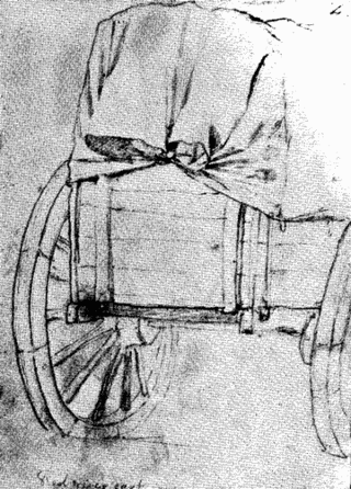
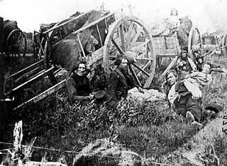
The Red River cart is a large two-wheeled cart made entirely of non-metallic materials. Often drawn by oxen, though also by horses or mules, these carts were used throughout most of the 19th century in the fur trade and in westward expansion in Canada and the United States, in the area of the Red River and on the plains west of the Red River Colony. The cart is a simple conveyance developed by Métis for use in their settlement on the Red River in what later became Manitoba. With carts, the Metis were not restricted to river travel to hunt bison. The Red River cart was largely responsible for commercializing the buffalo hunt.

<span class="mw-page-title-main">Savanna Portage State Park</span> United States historic place

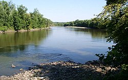
Savanna Portage State Park is a state park of Minnesota, USA, established in 1961 to preserve the historic Savanna Portage, a difficult 6-mile (9.7 km) trail connecting the watersheds of the Mississippi River and Lake Superior. The portage trail crosses a drainage divide separating the West Savanna River, which drains to the Mississippi River and the Gulf of Mexico, from the East Savanna River, which flows in an opposite direction to the Saint Louis River, Lake Superior and the Great Lakes, and the Saint Lawrence River to the Atlantic Ocean.

<span class="mw-page-title-main">Ishtakhaba</span>

Ishtakhaba, also known as Chief Sleepy Eyes, was a Native American chief of the Sisseton Dakota tribe. He became chief sometime between 1822 and 1825, receiving a commission from the Bureau of Indian Affairs as chief in 1824, and remained chief until his death in 1860. His band, known as the Swan Lake or Little Rock Band, hunted "in southwestern Minnesota and southeastern Dakota ... between Swan Lake and Coteau des Prairies," until forced to move to reservation land near the Minnesota River in the wake of the 1857 Spirit Lake Massacre.

<span class="mw-page-title-main">Huot, Minnesota</span> Unincorporated community in Minnesota, United States

Huot is an unincorporated community in Louisville Township, Red Lake County, Minnesota, United States. The name of the community evokes the French-Canadian and Métis history of the Red River Trails and the Pembina settlements of Assiniboia.

<span class="mw-page-title-main">Fort Abercrombie</span> United States historic place

Fort Abercrombie, in North Dakota, was an American fort established by authority of an act of Congress, March 3, 1857. The act allocated twenty-five square miles of land on the Red River of the North in Dakota Territory to be used for a military outpost, but the exact location was left to the discretion of Lieutenant Colonel John J. Abercrombie. The fort was constructed in the year 1858. It was the first permanent military settlement in what became North Dakota, and is thus known as "The Gateway to the Dakotas".

<span class="mw-page-title-main">Treaty of Traverse des Sioux</span> Upper Dakota land cession treaty of 1851 with United States

The Treaty of Traverse des Sioux was signed on July 23, 1851, at Traverse des Sioux in Minnesota Territory between the United States government and the Upper Dakota Sioux bands. In this land cession treaty, the Sisseton and Wahpeton Dakota bands sold 21 million acres of land in present-day Iowa, Minnesota and South Dakota to the U.S. for $1,665,000.

<span class="mw-page-title-main">Battles of New Ulm</span> Battle of the American Civil War

The Battles of New Ulm, also known as the New Ulm Massacre, were two battles in August 1862 between Dakota men and European settlers and militia in New Ulm, Minnesota. They were part of the Dakota War of 1862. The Dakota forces attacked New Ulm on August 19 and again on August 23. After the second attack, the town was evacuated.

<span class="mw-page-title-main">Dakota War of 1862</span> Armed conflict between the United States and four bands of the eastern Dakota

The US–Dakota War of 1862, also known as the Sioux Uprising, the Dakota Uprising, the Sioux Outbreak of 1862, the Dakota Conflict, or Little Crow's War, was an armed conflict between the United States and several bands of eastern Dakota also known as the Santee Sioux. It began on August 18, 1862, at the Lower Sioux Agency along the Minnesota River in southwest Minnesota.

<span class="mw-page-title-main">Height of Land Portage</span> Historic site in Minnesota / Thunder Bay District, Ontario

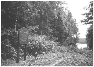
Height of Land Portage is a portage along the historic Boundary Waters route between Canada and the United States. Located at the border of the Canadian province of Ontario and the U.S. state of Minnesota, the path is a relatively easy crossing of the Laurentian Divide separating the Hudson Bay and Great Lakes-St. Lawrence watersheds.

<span class="mw-page-title-main">Red River Trails</span> Network of trails connecting the Red River Colony and Fort Garry in British North America

The Red River Trails were a network of ox cart routes connecting the Red River Colony and Fort Garry in British North America with the head of navigation on the Mississippi River in the United States. These trade routes ran from the location of present-day Winnipeg in the Canadian province of Manitoba across the Canada–United States border, and thence by a variety of routes through what is now the eastern part of North Dakota and western and central Minnesota to Mendota and Saint Paul, Minnesota on the Mississippi.

<span class="mw-page-title-main">Alexander Faribault House</span> Historic house in Minnesota, United States

The Alexander Faribault House is a historic house museum in Faribault, Minnesota, United States. Built in 1853, it was the first wood-frame house constructed in Rice County, Minnesota. It was built by fur trader Alexander Faribault in the Greek Revival style. Besides serving as a house, it also served as a civic center, polling place, and a church. The local address of the house is 12 First Avenue, Faribault, MN. The house was listed on the National Register of Historic Places in 1970.

<span class="mw-page-title-main">Treaty of Old Crossing</span> 1863 and 1864 treaties between the United States and Chippewa

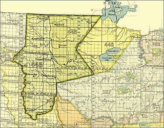
By the Treaty of Old Crossing (1863) and the Treaty of Old Crossing (1864), the Pembina and Red Lake bands of the Ojibwe, then known as Chippewa Indians, purportedly ceded to the United States all of their rights to the Red River Valley. On the Minnesota side, the ceded territory included all lands lying west of a line running generally southwest from the Lake of the Woods to Thief Lake, about 30 miles (48 km) west of Red Lake, and then angling southeast to the headwaters of the Wild Rice River near the low-lying divide separating the watershed of the Red River of the North from the watershed of the Mississippi River. On the North Dakota side, the ceded territory included all of the Red River Valley north of the Sheyenne River. The total land area, roughly 127 miles (204 km) wide east to west and 188 miles (303 km) long north to south, consisted of nearly 11,000,000 acres (45,000 km2) of rich prairie land and forests.

<span class="mw-page-title-main">Snake River Fur Post</span> United States historic place

The Snake River Fur Post is a reconstructed fur trade post on the Snake River west of Pine City, Minnesota, United States of America. The post was established in the fall of 1804 by John Sayer, a partner in the North West Company, and built by his crew of voyageurs. The site operated for several years, although its exact period of operation is unknown. It was later destroyed by fire.

<span class="mw-page-title-main">National Register of Historic Places listings in Nicollet County, Minnesota</span>

This is a list of the National Register of Historic Places listings in Nicollet County, Minnesota. It is intended to be a complete list of the properties and districts on the National Register of Historic Places in Nicollet County, Minnesota, United States. The locations of National Register properties and districts for which the latitude and longitude coordinates are included below, may be seen in an online map.

<span class="mw-page-title-main">Territorial era of Minnesota</span> Period in Minnesota history, 1803–1858

The territorial era of Minnesota lasted from the Louisiana Purchase in 1803 to Minnesota's achieving statehood in 1858. The Minnesota Territory itself was formed only in 1849 but the area had a rich history well before this. Though there was a long history of European presence in the area before 19th century, it was during the 19th century that the United States began to establish a firm presence in what would become Minnesota.

<span class="mw-page-title-main">Voyageurs</span> French Canadians who engaged in the North American fur trade

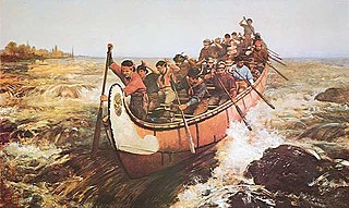
Voyageurs were 18th and 19th century French Canadians who transported furs by canoe at the peak of the North American fur trade. The emblematic meaning of the term applies to places and times where that transportation was over long distances. The voyageurs' strength and endurance was regarded as legendary. They were celebrated in folklore and music. For reasons of promised celebrity status and wealth, this position was coveted.

<span class="mw-page-title-main">Lac qui Parle Mission</span> United States historic place

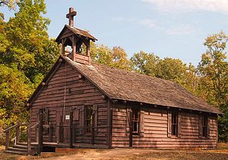
Lac qui Parle Mission is a pre-territorial mission in Chippewa County, Minnesota, United States, which was founded in June 1835 by Dr. Thomas Smith Williamson and Alexander Huggins after fur trader Joseph Renville invited missionaries to the area. Lac qui Parle is a French translation of the native Dakota name, meaning "lake which speaks". In the 19th century, the first dictionary of the Dakota language was written, and part of the Bible was translated into that language for the first time at a mission on the site of the park. It was a site for Christian missionary work to the Sioux for nearly 20 years. Renville was related to and had many friends in the Native community, and after his death in 1846, the mission was taken over by the "irreligious" Martin McLeod. The relationship between the mission and the Dakota people worsened, and in 1854 the missionaries abandoned the site and relocated to the Upper Sioux Agency.

Traverse is an unincorporated community in Traverse Township, Nicollet County, Minnesota, United States, near St. Peter. The community is located along Nicollet County Road 15, near its junctions with County Roads 19 and 40. The Traverse des Sioux Historic Site is nearby.

This timeline of South Dakota is a list of events in the history of South Dakota by year.

References

  1. 1 2 "National Register Information System". National Register of Historic Places . National Park Service. March 13, 2009.
  2. 1 2 3 4 5 Minnesota Historic Sites: Traverse des Sioux.
  3. 2013 Minnesota Statute § 138.585 subd. 28.
  4. Traverse des Sioux; Dylan Thomas, "Historic river crossing rediscovered", Minnesota Historic Sites. These sources use language similar to Thomas Hughes' paper presented to the Minnesota Historical Society on September 9, 1901, which states:
    Traverse des Sioux, being the French translation of its Dakota name Oiyuwega, (crossing), was then, and from time immemorial had been, the most important point on the Minnesota. The excellent river crossing there found, together with its position where the great forest of the east and the vast plains of the west naturally met, where the Blue Earth and its tributaries were conveniently accessible, and where the headwaters of the Minnesota and Red rivers could be reached by a short cut over land, made Traverse des Sioux the natural capital of the Sioux country.
    Hughes (1901), p. 104.
  5. Gilman (1979), p. 94, fn. 27.
  6. 1 2 Newsletter, Winter 2007. Minnesota Archaeological Society.
  7. Nute (1931), p. 61.
  8. Gilman (1979), pp. 40, 44.
  9. Nute (1931), p. 193.
  10. John C. Frémont describes his 1838 westward crossing of the traverse in his Memoirs:
    The Traverse des Sioux is a crossing-place about thirty miles long, where the river makes a large rectangular bend, coming down from the northwest and turning abruptly to the northeast . . . . In this great elbow of the river is the Marahtanka or Big Swan Lake, the summer resort of the Sissiton [Sisseton] Sioux. Our way over the crossing lay between the lake and the river. At the end of the Traverse we returned to the right shore at the mouth of the Waraju or Cottonwood River . . .
    Frémont, Memoirs of My Life (1886), p. 34; see also Gilman, p. 94, fn. 27.
  11. 1 2 Hughes (1901), p. 104.
  12. Meyer (1991), p. 31; Gilman (1979), pp. 5, 7.
  13. Gilman (1979), pp. 48-52.
  14. Lass (1978), pp. 110-11.
  15. Christianson (1935), pp. 211-13; Hughes (1901), pp. 100, 112.
  16. 1 2 3 Meyer (1991), p. 31.
  17. Meyer (1991), pp. 29-30.
  18. Treaty Site History Center.
  19. Map from Thomas Hughes, Old Traverse des Sioux, 1929.
  20. Dylan Thomas, "Historic river crossing rediscovered", Mankato Free Press , 18 December 2006.

Bibliography