Schoolcraft County is a county located in the Upper Peninsula of the U.S. state of Michigan. As of the 2020 Census, the population was 8,047, making it Michigan's fourth-least populous county. The county seat is Manistique, which lies along the northern shore of Lake Michigan. The county is named in honor of Henry Schoolcraft, who explored the area with the expedition of Lewis Cass. The county was founded in 1843 and organized in 1876. The county is largely rural and forested, with much of its western portion within Hiawatha National Forest.

Delta County is a county in the Upper Peninsula in the U.S. state of Michigan. As of the 2020 Census, the population was 36,903. The county seat is Escanaba. The county was surveyed in 1843 and organized in 1861. Its name originates from the Greek letter Δ, which refers to the triangular shape of the original county which included segments of Menominee, Dickinson, Iron, and Marquette counties. Recreation and forest products are major industries, and crops include hay, corn, small grains, potatoes, and strawberries.

Manistique, formerly Monistique, is the only city and county seat of Schoolcraft County in the U.S. state of Michigan. As of the 2020 census, the city population was 2,828.

Lake Itasca is a small glacial lake, approximately 1.8 square miles in area. Located in southeastern Clearwater County, in the Headwaters area of north central Minnesota, it is notable for being the headwater of the Mississippi River. The lake is in Itasca State Park. It has an average depth of 20 to 35 feet and is 1,475 feet (450 m) above sea level.

Henry Rowe Schoolcraft was an American geographer, geologist, and ethnologist, noted for his early studies of Native American cultures, as well as for his 1832 expedition to the source of the Mississippi River. He is also noted for his major six-volume study of Native Americans commissioned by Congress and published in the 1850s.
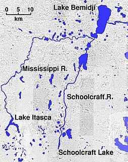
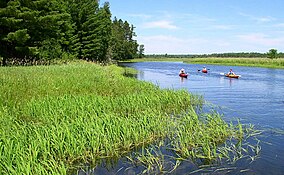
The Schoolcraft River is a tributary of the Mississippi River, approximately 30 mi (48 km) long, in northern Minnesota in the United States. Although short, it is considered as the first major tributary of the Mississippi, since it is the first river that joins the Mississippi below its source that is nearly the same size as the Mississippi itself. The river is named after Henry Schoolcraft, who mapped the region and discovered nearby Lake Itasca as the source of the Mississippi in 1831. Its name in the Ojibwe language is Ozaawindibe-ziibi, named after Ozaawindib who guided Schoolcraft to the nearby Omashkoozo-zaaga'igan, which Schoolcraft then named Lake Itasca. Prior to being named for these early explorers it had been called the "Naiwa River"

The Leelanau Peninsula is a peninsula of the U.S. state of Michigan that extends about 30 miles (50 km) from the western side of the Lower Peninsula of Michigan into Lake Michigan. Leelanau County encompasses the entire peninsula. It is often referred to as the "little finger" of the mitten-shaped lower peninsula.

H-13 is a county-designated highway in the Upper Peninsula of the US state of Michigan that runs north–south for approximately 36.2 miles (58.3 km) between Nahma Junction in Delta County and the Munising area in Alger County. The highway is also signed as Federal Forest Highway 13 (FFH-13), a Federal Forest Highway between Nahma Junction and Wetmore. The roadway runs through rural national forest lands providing access to several campgrounds and parks. The area contains several lakes as well. The Forest Highway System dates back to the 1920s, and an earthen roadway was present along the route of FFH-13 by the 1930s. It was paved by the late 1940s and added to the county-designated highway system in the 1970s. A section of H-13 in Alger County originally continued north to Miners Castle, but the roadway designation was truncated in the first decade of the 21st century.

The Grave Creek Mound in the Ohio River Valley in West Virginia is one of the largest conical-type burial mounds in the United States, now standing 62 feet (19 m) high and 240 feet (73 m) in diameter. The builders of the site, members of the Adena culture, moved more than 60,000 tons of dirt to create it about 250–150 BC.
Schoolcraft College is a public community college in Livonia, Michigan. It also has a satellite campus in Garden City, Michigan.

This is a list of the National Register of Historic Places listings in Charlevoix County, Michigan.

The Richard and Jane Manoogian Mackinac Art Museum is an art museum located in the historic Indian Dormitory building on Mackinac Island, Michigan. The museum's exhibits feature art inspired by Mackinac Island, including historic painting and maps, photographs from the mid-19th to the mid-20th century, Native American art and beaded garments, and contemporary art and photography from area artists.

Minnesota State Highway 6 is a 147.775-mile-long (237.821 km) highway in east-central and north-central Minnesota, which runs from its intersection with State Highway 18 in Bay Lake Township near Garrison and continues north to its northern terminus at its intersection with U.S. Highway 71 and County Road 30 in Big Falls.
Lac Courte Oreilles is a large freshwater lake located in northwest Wisconsin in Sawyer County in townships 39 and 40 north, ranges 8 and 9 west. It is irregular in shape, having numerous peninsulas and bays, and is approximately six miles long in a southwest to northeast direction and with a maximum width of about two miles (3 km). Lac Courte Oreilles is 5,039 acres (20.39 km2) in size with a maximum depth of 90 feet (27 m) and a shoreline of 25.4 miles (40.9 km). The lake has a small inlet stream that enters on the northeast shore of the lake and flows from Grindstone Lake, a short distance away to the north. An outlet on the southeast shore of the lake leads through a very short passage to Little Lac Courte Oreilles, then via the Couderay River to the Chippewa River, and ultimately to the Mississippi River at Lake Pepin.

Jane Johnston Schoolcraft, also known as Bamewawagezhikaquay is the one of earliest Native American literary writers. She was of Ojibwa and Scots-Irish ancestry. Her Ojibwa name can also be written as O-bah-bahm-wawa-ge-zhe-go-qua, meaning "Woman of the Sound [that the stars make] Rushing Through the Sky." From babaam- 'place to place' or bimi- 'along', wewe- 'makes a repeated sound', giizhig 'sky', and ikwe 'woman'. She lived most of her life in Sault Ste. Marie, Michigan.
The Lewis Cass expedition of 1820 was a survey of the western part of Michigan Territory led by Lewis Cass, governor of the territory. On January 14, 1820, United States Secretary of War John C. Calhoun authorized Cass to lead a party of scientists, soldiers, Canadian voyageurs, and Native Americans into the wilderness of western Michigan Territory. The purpose of the expedition was to:
Windigo Lake is a freshwater lake located in north central Wisconsin in the Town of Bass Lake, Sawyer County, United States, in township 40 north, range 9 west. The lake is irregular in shape, with numerous peninsulas and bays, and is approximately one mile in diameter. Windigo Lake is 529.6 acres (2.143 km2) in size with a maximum depth of 51 feet (16 m) and a shoreline of 9 miles (14 km). The lake does not have an obvious inflow or outflow stream and is classified as a seepage lake, i.e., a lake without an inlet or an outlet.
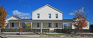
Elmwood, also known as the Henry Rowe Schoolcraft House, the Schoolcraft House or the Indian Agency, is a frame house located at 435 East Water Street in Sault Ste. Marie, Michigan. It was designated a Michigan State Historic Site in 1956 and listed on the National Register of Historic Places in 1974.

The John Johnston House is a private house located at 415 Water Street in Sault Ste. Marie, Michigan. It was listed on the National Register of Historic Places in 1970 and designated a Michigan State Historic Site in 1958.
The Kalamazoo and White Pigeon Railroad (K&WP) was a shortline railroad in the U.S. state of Michigan. The line ran from Lansing to Jonesville, then returned north from Jonesville to Albion and Eaton Rapids before closing the loop in Lansing. The NCMR had a short life as an independent company, becoming part of the Lake Shore and Michigan Southern Railway in 1871 and then consolidating with the New York Central Railroad in 1914.