
Grand Portage State Park is a state park at the northeastern tip of the U.S. state of Minnesota, on the Canada–United States border. It contains a 120-foot (37 m) waterfall, the tallest in the state, on the Pigeon River. The High Falls and other waterfalls and rapids upstream necessitated a historically important portage on a fur trade route between the Great Lakes and inland Canada. This 8.5-mile (13.7 km) path as well as the sites of historic forts at either end are preserved in nearby Grand Portage National Monument.

Buffalo River State Park is a state park of Minnesota, United States, conserving a prairie bisected by the wooded banks of the Buffalo River. Together with the adjacent Bluestem Prairie Scientific and Natural Area co-owned by The Nature Conservancy and Minnesota's Department of Natural Resources, it protects one of the largest and highest-quality prairie remnants in Minnesota. It use to offer a man-made swimming pond close to the Fargo–Moorhead metropolitan area, however, that has not been open since 2018. Presently, it is most popular for its high quality educational programming, swimming in the Buffalo River, and picnicking. The 1,068-acre (432 ha) park is located just off U.S. Route 10 in Clay County, 4.5 miles (7.2 km) east of Glyndon and 14 miles (23 km) east of Moorhead.
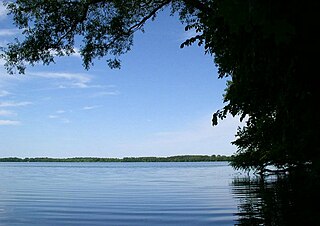
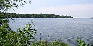
Myre-Big Island State Park is a state park of Minnesota, USA, just outside the city of Albert Lea. It has an area of 1,578 acres (6.39 km2). The park protects 8 miles (13 km) of shoreline on Albert Lea Lake. The nucleus of the park is Big Island, a 117-acre (0.47 km2) island attached to the mainland by a causeway. In turn a causeway connects Big Island to Little Island. The park was formerly named Helmer Myre State Park after former Minnesota State Senator Helmer Myre.

Minneopa State Park is a state park in the U.S. state of Minnesota. It was established in 1905 to preserve Minneopa Falls, a large waterfall for southern Minnesota, and was expanded in the 1960s to include the lower reaches of Minneopa Creek and a large tract of prairie. Minneopa is Minnesota's third oldest state park, after Itasca and Interstate. Two park resources are listed on the National Register of Historic Places: the 1862 Seppman Mill and a district of seven Rustic Style structures built by the Works Progress Administration in the late 1930s. The park is located almost entirely on the south side of the Minnesota River, three miles (4.8 km) west of Mankato. In 2015 the state reintroduced American bison to the park in a 330-acre (130 ha) fenced enclosure, through which visitors can drive in their vehicles.

Nerstrand-Big Woods State Park is a state park of Minnesota, US, northeast of Faribault just outside the small town of Nerstrand. The park derives its name from the Big Woods, a large, contiguous forested area covering much of southeast Minnesota prior to the 1840s, when European settlers began to establish farms in the territory, and from Nedstrand in Tysvær, Norway, of which Nerstrand is a namesake. The park and its forest were an outlying 'woods' typical of and similar to the Big Woods proper, which were historically found on the more recent glacier deposits located west of the Cannon River 10 miles (16 km) to the west. Aside from a small waterfall, the outstanding natural feature of the park is the forest itself.

Bear Head Lake State Park is a state park of Minnesota, United States, providing ready access to outdoor recreation in the Boundary Waters region. It boasts scenery similar to the nearby Boundary Waters Canoe Area Wilderness, with the added conveniences of road access, modern facilities, and motorboating. The most popular visitor activities are boating, fishing, swimming, and hiking. The park entirely surrounds 670-acre (270 ha) Bear Head Lake and three other fishing lakes. It was established in 1961 in Saint Louis County near Ely, Minnesota. The park also contains the woodlands surrounding the lakes, which gives an entire total of about 5,540 acres. The park also shares a large border with Bear Island State Forest.

Judge C. R. Magney State Park is a state park in the U.S. state of Minnesota, on the North Shore of Lake Superior. It was named for Clarence R. Magney, a former mayor of Duluth and justice of the Minnesota Supreme Court, who was instrumental in getting 11 state parks and scenic waysides established along the North Shore. The park is best known for the Devil's Kettle, an unusual waterfall and rock formation in which half of the Brule River disappears into a pothole.

St. Croix State Park is a state park in Pine County, Minnesota, USA. The park follows the shore of the St. Croix River for 21 miles (34 km) and contains the last 7 miles (11 km) of the Kettle River. At 33,895 acres (13,717 ha) it is the largest Minnesota state park. It was developed as a Recreational Demonstration Area in the 1930s, and is one of the finest surviving properties of this type in the nation. 164 structures built by the Civilian Conservation Corps and the Works Progress Administration survive, the largest collection of New Deal projects in Minnesota. As a historic district they were listed on the National Register of Historic Places and proclaimed a National Historic Landmark in 1997.
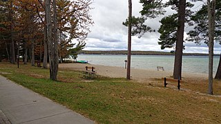
Sakatah Lake State Park is an 842-acre (341 ha) state park of Minnesota, USA, on a natural widening of the Cannon River near the town of Waterville. The Dakota native to the area called it "Sakatah" which means "singing hills". To honor this native heritage, some of the trails in the park have been given Dakota names. The Sakatah Singing Hills State Trail, which connects Faribault and Mankato, runs through this park.

Monson Lake State Park is a state park of Minnesota, USA, originally established as a memorial to 13 Swedish American pioneers who were killed there in the Dakota War of 1862. A district of 1930s New Deal structures is on the National Register of Historic Places. Despite being nearly doubled in size in 2009, the state park remains one of Minnesota's smallest. It is located off Minnesota State Highway 9 just west of Sunburg and 20 miles (32 km) northwest of Willmar. This seasonally-staffed park is managed from nearby Sibley State Park.

Lake Shetek State Park is a state park of Minnesota, United States, on Lake Shetek, which is the largest lake in southwestern Minnesota and the headwaters of the Des Moines River. It is most popular for water recreation and camping. However the park also contains historical resources related to the Dakota War of 1862, including an original log cabin and a monument to 15 white settlers killed there and at nearby Slaughter Slough on August 20, 1862.

Big Bog State Recreation Area, a recent addition to the Minnesota state park system, is located on Minnesota State Highway 72, north of Waskish, Minnesota. It covers 9,459 acres (38.3 km2), primarily swamps, bogs, and upland "islands".

Lake Maria State Park is a state park of Minnesota, United States, created to provide a wilderness area within an easy drive of Minneapolis–Saint Paul. The park's amenities are designed primarily for hikers, backpackers, and horseback riders and consequently use remains light compared to other state parks around the metro area. It preserves a remnant of Big Woods atop a hilly, glacially-formed landscape dotted with lakes and wetlands. The park was established in 1963 west of the city of Monticello.

The Minnesota Department of Natural Resources, or Minnesota DNR, is the agency of the U.S. state of Minnesota charged with conserving and managing the state's natural resources. The agency maintains areas such as state parks, state forests, recreational trails, and recreation areas as well as managing minerals, wildlife, and forestry throughout the state. The agency is divided into six divisions - Ecological & Water Resources, Enforcement, Fish & Wildlife, Forestry, Lands & Minerals, and Parks & Trails.
South Higgins Lake State Park is a public recreation area covering 1,000 acres (400 ha) on the southern shore of Higgins Lake five miles southwest of Roscommon in Roscommon County, Michigan. The state park occupies one mile of shoreline on Higgins Lake and entirely surrounds Marl Lake and portions of the Cut River.
The Bear Island State Forest is a state forest in Minnesota bordered by the towns of Ely, Babbitt, and Tower in Lake and Saint Louis counties. It is adjacent to the Burntside State Forest and the federally managed Superior National Forest and Boundary Waters Canoe Area Wilderness. It is managed primarily by the Minnesota Department of Natural Resources and the counties.
The Foot Hills State Forest is a state forest located in Cass and Hubbard counties, Minnesota. The forest is a popular recreation spot due to its proximity to the greater Minneapolis – Saint Paul metropolitan area.
The Hill River State Forest is a state forest located in Aitkin County, Minnesota. It borders the Savanna State Forest to the east, and the Chippewa National Forest and the Land O'Lakes State Forest to the west. The majority of the forest is managed by the Minnesota Department of Natural Resources.
The Rum River State Forest is a state forest located in Kanabec, Mille Lacs and Morrison counties in central Minnesota. The forest is nearby the city of Onamia and is along the Rum River, just downstream (south) of Mille Lacs Lake. The forest is managed by the Minnesota Department of Natural Resources. The forest is home to many Northern hardwoods such as maple, oak, ash, elm and basswood that occupy most of the upland areas while tamarack and black spruce are found in lowland and marshy areas.


