
Lake Michigan is one of the five Great Lakes of North America. It is the second-largest of the Great Lakes by volume and the third-largest by surface area, after Lake Superior and Lake Huron. To the east, its basin is conjoined with that of Lake Huron through the narrow Straits of Mackinac, giving it the same surface elevation as its easterly counterpart; the two are technically a single lake.

Lac qui Parle County is a county in the U.S. state of Minnesota. As of the 2020 census, the population was 6,719. Its county seat is Madison. The largest city in the county is Dawson.

Big Stone County is a county in the U.S. state of Minnesota. As of the 2020 census, the population was 5,166. Its county seat is Ortonville.
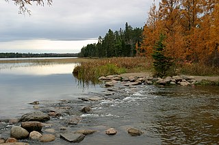
Itasca State Park is a state park of Minnesota, United States, and contains the headwaters of the Mississippi River. The park spans 32,690 acres (132.3 km2) of northern Minnesota, and is located about 21 miles (34 km) north of Park Rapids, Minnesota and 25 miles (40 km) from Bagley, Minnesota. The park is part of Minnesota's Pine Moraines and Outwash Plains Ecological Subsection and is contained within Clearwater, Hubbard, and Becker counties.

Minnesota State Highway 7, or Trunk Highway 7, is a state highway in Minnesota, which runs from its intersection with MN 28 near Beardsley and continues east to its terminus with MN 100 and County Road 25 (CR 25) in St. Louis Park. The highway runs east–west for approximately 194.2 miles (312.5 km) through mostly rural farmland in the central part of the state. On its western end, it is part of the Minnesota River Valley Scenic Byway where it runs northwest–southeast along the Minnesota River and associated lakes near the border with the adjoining state of South Dakota. For roughly 24 miles (39 km) of its route, it runs concurrently with U.S. Highway 59 (US 59) between Appleton and Montevideo. In Montevideo, the highway turns to the east cutting across the state. It passes through several small towns before entering the Twin Cities metropolitan area. In the metro area, MN 7 follows an expressway through several suburbs before terminating in St. Louis Park. Two different segments have been listed on the National Highway System, system of roads considered important to the country.

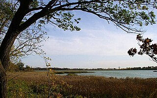
Big Stone Lake is a long, narrow freshwater lake and reservoir on the border between western Minnesota and northeastern South Dakota in the United States.

Lake Traverse is the southernmost body of water in the Hudson Bay watershed of North America. It lies along the border between the U.S. states of Minnesota and South Dakota. A low continental divide separates the land at the southern shore of Lake Traverse from Big Stone Lake, the headwaters of the south-flowing Little Minnesota River, which is part of the Mississippi River System. Both lakes lie within a mile of the town of Browns Valley, Minnesota with Wheaton, Minnesota ; and Ortonville, Minnesota.

The North Shore of Lake Superior runs from Duluth, Minnesota, United States, at the western end of the lake, to Thunder Bay and Nipigon, Ontario, Canada, in the north, to Sault Ste. Marie, Ontario in the east. The shore is characterized by alternating rocky cliffs and cobblestone beaches, with forested hills and ridges through which scenic rivers and waterfalls descend as they flow to Lake Superior.

Gooseberry Falls State Park is a state park of Minnesota, United States, on the North Shore of Lake Superior. The park is located in Silver Creek Township, about 13 miles (21 km) northeast of Two Harbors, Minnesota in Lake County on scenic Minnesota Highway 61. The park surrounds the mouth of the Gooseberry River and includes Upper, Middle and Lower Gooseberry Falls.
Rice Lake State Park is a state park of Minnesota, United States, just east of Owatonna. Park lands entirely surround Rice Lake, an important stopping point for migrating waterfowl. The lake covers 750 acres (300 ha) with an average depth of three feet (1 m).

Judge C. R. Magney State Park is a state park in the U.S. state of Minnesota, on the North Shore of Lake Superior. It was named for Clarence R. Magney, a former mayor of Duluth and justice of the Minnesota Supreme Court, who was instrumental in getting 11 state parks and scenic waysides established along the North Shore. The park is best known for the Devil's Kettle, an unusual waterfall and rock formation in which half of the Brule River disappears into a pothole.
Sakatah Lake State Park is an 842-acre (341 ha) state park of Minnesota, USA, on a natural widening of the Cannon River near the town of Waterville. The Dakota native to the area called it "Sakatah" which means "singing hills". To honor this native heritage, some of the trails in the park have been given Dakota names. The Sakatah Singing Hills State Trail, which connects Faribault and Mankato, runs through this park.

Scenic State Park is a Minnesota state park near Bigfork in Itasca County. It encompasses 3,936 acres (1,593 ha) of virgin pine forests that surround Coon-Sandwick Lake. It also includes portions of Lake of Isles, Tell Lake, Cedar Lake and Pine Lake. Established in 1921, the Ojibwe tribe had previously used the area for hunting. The park has places for camping, hiking, swimming, fishing, and canoeing.

Big Bog State Recreation Area, a recent addition to the Minnesota state park system, is located on Minnesota State Highway 72, north of Waskish, Minnesota. It covers 9,459 acres (38.3 km2), primarily swamps, bogs, and upland "islands".

Lake Maria State Park is a state park of Minnesota, United States, created to provide a wilderness area within an easy drive of Minneapolis–Saint Paul. The park's amenities are designed primarily for hikers, backpackers, and horseback riders and consequently use remains light compared to other state parks around the metro area. It preserves a remnant of Big Woods atop a hilly, glacially-formed landscape dotted with lakes and wetlands. The park was established in 1963 west of the city of Monticello.

The U.S. State of Minnesota is the northernmost state outside Alaska; its isolated Northwest Angle in Lake of the Woods is the only part of the 48 contiguous states lying north of the 49th parallel north. Minnesota is in the U.S. region known as the Upper Midwest in interior North America. The state shares a Lake Superior water border with Michigan and Wisconsin on the northeast; the remainder of the eastern border is with Wisconsin. Iowa is to the south, North Dakota and South Dakota are to the west, and the Canadian provinces of Ontario and Manitoba are to the north. With 87,014 square miles (225,370 km2), or approximately 2.26% of the United States, Minnesota is the 12th largest state.

The Traverse Gap is an ancient river channel occupied by Lake Traverse, Big Stone Lake and the valley connecting them at Browns Valley, Minnesota. It is located on the border of the U.S. states of Minnesota and South Dakota. Traverse Gap has an unusual distinction for a valley: it is crossed by a continental divide, and in some floods water has flowed across that divide from one drainage basin to the other. Before the Anglo-American Convention of 1818 it marked the border between British territory in the north and U.S. – or earlier, French – territory in the south.

Straddling the headwaters of the Minnesota River in west-central Minnesota, Big Stone National Wildlife Refuge is within the heart of the tallgrass prairie's historic range. Today, less than one-percent of tallgrass prairie remains.
Mini-Wakan State Park is located north of Spirit Lake, Iowa, United States. The 20-acre (8.1 ha) park is along the north shore of Big Spirit Lake. It provides space for picnicking, hiking, biking, swimming, boating and fishing on the lake. The park is connected to the Dickinson County trail system in Iowa and the Jackson County trail system in Minnesota. It was listed as a historic district on the National Register of Historic Places in 2010.


