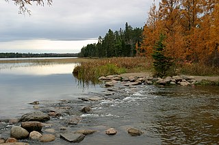
Itasca State Park is a state park of Minnesota, United States, and contains the headwaters of the Mississippi River. The park spans 32,690 acres (132.3 km2) of northern Minnesota, and is located about 21 miles (34 km) north of Park Rapids, Minnesota and 25 miles (40 km) from Bagley, Minnesota. The park is part of Minnesota's Pine Moraines and Outwash Plains Ecological Subsection and is contained within Clearwater, Hubbard, and Becker counties.

Bear Head Lake State Park is a state park of Minnesota, United States, providing ready access to outdoor recreation in the Boundary Waters region. It boasts scenery similar to the nearby Boundary Waters Canoe Area Wilderness, with the added conveniences of road access, modern facilities, and motorboating. The most popular visitor activities are boating, fishing, swimming, and hiking. The park entirely surrounds 670-acre (270 ha) Bear Head Lake and three other fishing lakes. It was established in 1961 in Saint Louis County near Ely, Minnesota. The park also contains the woodlands surrounding the lakes, which gives an entire total of about 5,540 acres. The park also shares a large border with Bear Island State Forest.
The Crow Wing State Forest is a state forest located near Fairfield Township in Crow Wing County, Minnesota. It is about 20 miles (32 km) northeast of the tourism-based town of Brainerd. Approximately 14,072 acres (5,695 ha) (44%) of the forest of 31,307 acres (12,669 ha) is actively managed. The managed acres are split nearly equally between the Minnesota Department of Natural Resources, Crow Wing County, and the privately owned Potlatch Corp.
The Finland State Forest is a state forest located near the unincorporated community of Finland in Lake and Cook counties, Minnesota. Of the over 30,000 acres (12,000 ha), the Minnesota Department of Natural Resources manages a third of the land. The federal United States Forest Service manages roughly a quarter of the total forest acreage, as its boundary overlaps in part with that of Superior National Forest. The remainder is split between Cook and Lake County agencies, and private landowners.
The Beltrami Island State Forest is a state forest located in Lake of the Woods, Roseau, and Beltrami counties, Minnesota. Named after Italian explorer Giacomo Beltrami, it is the second-largest state forest in the Minnesota system after Pine Island State Forest. The largest wildlife management area in the state at 321,149 acres (129,964 ha), the Red Lake Wildlife Management Area, is located within the forest. The majority of the forest is managed by the Minnesota Department of Natural Resources, although a significant portion are tribal lands belonging to the neighboring Red Lake Band of Ojibwe.
The Birch Lakes State Forest is a state forest located in Stearns County, Minnesota. One of the smallest Minnesota state forests, it is managed primarily for recreation by the Minnesota Department of Natural Resources. Big Birch Lake, a 2,112 acres (855 ha) sand- and marl-bottomed lake, is accessible from the northeast corner of the forest. The forest is located in a transitory ecotone between the temperate deciduous forest to the northeast and the tallgrass prairie to the southwest, with the rolling terrain characteristic of the glacial activity in the area.
The Buena Vista State Forest is a state forest located in Beltrami County, Minnesota. The Minnesota Department of Natural Resources manages 18,693 acres (7,565 ha) of state lands, with the majority of the forest split between private and other public ownership. The eastern half of the forest falls within the Chippewa National Forest, where Federal lands are managed by the United States Forest Service.
The Foot Hills State Forest is a state forest located in Cass, and Hubbard counties, Minnesota. The forest is a popular recreation spot due to its proximity to the greater Minneapolis – Saint Paul metropolitan area.
The General C. C. Andrew State Forest is a state forest located in Pine County, Minnesota. The forest is named in honor of major general Christopher Columbus Andrews, a Civil War veteran, and an early Minnesota state Forestry Commissioner and proponent for scientific forestry and forest management. The Minnesota Department of Natural Resources manages the majority of the forest.
The George Washington State Forest is a state forest located in Itasca, Koochiching, and Saint Louis counties, Minnesota. The forest was established and named after George Washington in 1931, the first President of the United States, to commemorate the bicentennial of his birth. The forest borders the Chippewa National Forest and completely environs the Scenic State Park to the west, and borders the Sturgeon River State Forest and McCarthy Beach State Park to the east. The Taconite State Trail passes through the forest.
The Golden Anniversary State Forest is a state forest located near Grand Rapids in southern Itasca County, Minnesota. The forest was established in 1961 in celebration of the golden anniversary of the Minnesota Department of Natural Resources's Division of Forestry, which is responsible for the management of the majority of the state forests in Minnesota.

The Grand Portage State Forest is a state forest located near the community of Hovland in Cook County, in extreme northeastern Minnesota. The forest encloses Judge C. R. Magney State Park, Swamp River Wildlife Management Area, Hovland Woods Scientific and Natural Area, and Spring Beauty Hardwoods Scientific and Natural Area. It borders the Grand Portage Indian Reservation to the east, the Superior National Forest to the west, and Ontario to the north. The forest is named after the Grand Portage, a historic trade route between the Great Lakes and the Northwest.
The Huntersville State Forest is a state forest located in Wadena County, Minnesota. Around half of the forest is managed by the Minnesota Department of Natural Resources, with the other half controlled privately.
The Kabetogama State Forest is a state forest located in Koochiching and Saint Louis counties, Minnesota, United States. The forest borders the Superior National Forest and the Boundary Waters Canoe Area Wilderness to the east, the Sturgeon River State Forest to the south, the Nett Lake Indian Reservation to the west, and Voyageurs National Park to the north. The forest is managed by the Minnesota Department of Natural Resources.
The Koochiching State Forest is a state forest located near International Falls in Itasca, Koochiching, and Saint Louis counties, Minnesota. The forest borders the Pine Island State Forest to the west, the Big Fork State Forest and George Washington State Forest to the south, the Nett Lake Indian Reservation and the Kabetogama State Forest to the east. A leg of the forest touches Rainy Lake to the north, which forms part of the international border with Ontario. Of the 565,500 acres (2,288 km2), 344,300 acres (1,393 km2) are managed by the Minnesota Department of Natural Resources, making it one of the largest forests in the Minnesota state system.
The Land o' Lakes State Forest is a state forest located primarily in Cass, Minnesota, with portions extending into adjacent Aitkin and Crow Wing counties. The forest has small shared borders with the Chippewa National Forest to the north, and the Hill River State Forest to east. Over half of the forest's land is managed by the Minnesota Department of Natural Resources; the remaining land is managed by Cass County or is privately held.
The Mississippi Headwaters State Forest is a state forest located near the town of Wilton in Beltrami County, Minnesota. Portions of the forest extend into the neighboring counties of Clearwater and Hubbard. The majority of the forest is managed by the respective counties, with the Minnesota Department of Natural Resources managing around 9,000 acres (3,600 ha). The forest is named after its location immediately downstream (north) of Lake Itasca, the headwaters of the Mississippi River.
The Nemadji State Forest is a state forest located primarily in Pine County, Minnesota. A small portion of the forest extends into neighboring Carlton County. The eastern perimeter of the forest borders the state of Wisconsin. It is managed by the Minnesota Department of Natural Resources. Gray wolves, white-tailed deer, and eagles are present in the forest.
The Paul Bunyan State Forest is a state forest located in Hubbard and Cass counties in Minnesota. The forest borders the Chippewa National Forest and the Welsh Lake State Forest to the east, and the Mississippi Headwaters State Forest to the northwest. The forest is managed by the Minnesota Department of Natural Resources and the land department for Hubbard County.
The Pine Island State Forest is a Minnesota state forest located primarily in Koochiching County, although there are portions that extend into Beltrami, Lake of the Woods, and Itasca counties. The forest borders the Koochiching State Forest to the east, the Red Lake State Forest to the west, and Big Fork State Forest and Chippewa National Forest to the south. At an area of 878,040 acres (355,330 ha), it is the largest state forest in Minnesota.
