Split Rock Lighthouse State Park

Last updated

Split Rock Lighthouse State Park
SplitRockLighthouseEllingsonIslandMN.jpg
Split Rock Lighthouse State Park seen from the shore of Lake Superior
USA Minnesota relief location map.svg
Red pog.svg
Location of Split Rock Lighthouse State Park in Minnesota
Usa edcp relief location map.png
Red pog.svg
Split Rock Lighthouse State Park (the United States)
Location Lake, Minnesota, United States
Coordinates 47°11′31″N91°23′34″W / 47.19194°N 91.39278°W / 47.19194; -91.39278 Coordinates: 47°11′31″N91°23′34″W / 47.19194°N 91.39278°W / 47.19194; -91.39278
Area2,200 acres (8.9 km2)
Elevation728 ft (222 m) [1]
Established1945
Named for Split Rock Lighthouse
Governing bodyMinnesota Department of Natural Resources

Split Rock Lighthouse State Park is a state park of Minnesota on the North Shore of Lake Superior. It is best known for the picturesque Split Rock Lighthouse, one of the most photographed lighthouses in the United States. [2] Built by the United States Lighthouse Service in 1910, the lighthouse and some adjacent buildings have been restored and the Minnesota Historical Society operates them as a museum. The 2,200-acre (890 ha) state park offers a unique cart-in campground and scenic trails for hiking, cross-country skiing, and bicycling.

Contents

Natural history

Geography

Split Rock Lighthouse State Park encompasses about four miles (6.4 km) of rocky shoreline on Lake Superior with several prominent headlands. Named features of the shore, from southwest to northeast, are the mouth of the Split Rock River, Split Rock Point, Crazy Bay, Corundum Point, the mouth of Split Rock Creek, Day Hill, Little Two Harbors, Stony Point (site of the lighthouse), and Gold Rock Point. [3] The name Little Two Harbors comes from the division of the inlet by a small island, formerly a tombolo, [4] and refers to the city of Two Harbors farther down the shore. There are two shallow sea caves at the base of Stony Point. [5]

The east and west branches of the Split Rock River, not to be confused with Split Rock Creek, join in the park. There are ten waterfalls on the river, although because they can only be reached by a moderate hike on the Superior Hiking Trail and are not marked on park maps, they are lightly visited. [6]

Geology

Much of the shore of Lake Superior is made of basalt erupted from the Midcontinent Rift System when the middle of the North American Plate began to crack 1.1 billion years ago. In a small tract that includes Split Rock Lighthouse State Park, additional magma intruded into the basalt and cooled underground into a harder rock called diabase. These flows also carried with them blocks of anorthosite, an even harder rock from the base of the Earth's crust, which became interspersed randomly in the diabase. [4] Three large blocks of anorthosite form Corundum Point, Day Hill, and Stony Point beneath the lighthouse. In the southwest portion of the park another eruption formed a layer of red rhyolite. The rhyolite has eroded into several natural pillars, and forms the walls of the Split Rock River gorge. [4] [7]

Beginning 2 million years ago a series of glacial periods repeatedly covered the region with ice, scouring the bedrock and scooping out a great basin. [2] The glaciers, and later meltwater, wore away less resistant rock, leaving behind hills and ridges of the harder diabase and anorthosite. [3] [4] At the end of the last glacial period the basin filled with meltwater. The water level fluctuated significantly over time due to blockages of the outlet and post-glacial rebound. The high-water Glacial Lake Duluth deposited clay sediments inland, while later, lower precursors of Lake Superior eroded bluffs and beach terraces. [4]

Flora and fauna

Vegetation in the park Split RockMN arf5.JPG
Vegetation in the park

The park was originally forested with red and white pine. However, these were heavily logged at the beginning of the 20th century, and wildfires sweeping through the cutover land killed many of the remaining saplings and seedlings. Today the vegetation is primarily birch with some spruce, fir, and ash trees. [3]

Mammals found in the park include white-tailed deer, moose, black bears, raccoons, snowshoe hares, red foxes, bobcats, and Canadian lynxes. [2] A colony of beavers lives on the Split Rock River. [3] Birds include herring gulls, common loons, and a variety of songbirds. [2] Peregrine falcons nest on the lakeside cliffs. [3]

Cultural history

Early history

Several vestiges of early 20th-century industry are visible in the park. The first white settlement in the Split Rock area was Little Two Harbors, a commercial fishing village populated largely by Norwegian immigrants. [3] The men of the village fished for trout, whitefish, and herring from 16–18 foot skiffs in the fall and winter. [7] Little Two Harbors was inhabited until 1925, although in later years only 4 or 5 residents lived there year-round. [8] Cement foundations of houses and fish processing buildings remain. [7]

A logging camp known as Splitrock existed at the mouth of the Split Rock River from 1899 to 1906. Pilings from their dam and wharf are still visible jutting from the water. [9] The Merrill Logging Trail follows the route of their 10-mile (16 km) rail line. [7] In 1901 a prospector from Duluth misidentified the outcrops of anorthosite as corundum, an extremely hard mineral valuable as an industrial abrasive. Three years later the North Shore Abrasives Company set up mining operations on Corundum Point, but abandoned the site in 1908 when their product was found to be inadequate. Their crushing house burned down in a forest fire in 1910 but its concrete footings remain. [7]

Another remnant from this period is a finely crafted, freestanding stone fireplace atop Day Hill. According to local legend it was the start of a house built around 1900 by Frank Day, a businessman from Duluth, for himself and his sweetheart, but abandoned when she did not reciprocate his love. [6] [10]

Split Rock Lighthouse

Three violent storms struck the Great Lakes in November 1905, killing 116 sailors. [8] One, the Mataafa Storm of November 28, damaged nearly 30 ships on Lake Superior. Two ships were wrecked against the future park's shore, the steel steamboat William Edenborn and a barge it was towing, the Madeira . The Edenborn was beached far ashore at the mouth of the Split Rock River and later salvaged, but one of the 25 crewmembers was killed. The Madeira with 10 men aboard drifted northeast until violent waves began smashing her against the cliffs of Gold Rock Point. Crewman Fred Benson managed to leap onto the rocks and scale the cliff in the midst of the snowstorm. The first mate was swept overboard and drowned, but Benson was able to lower a rope and pull the other eight crew to safety. The Madeira sank in pieces at the foot of Gold Rock while the crewmen, suffering from exposure and frostbite, found shelter with local fishermen and loggers. Both crews were picked up two days later by the tugboat Edna G . [11]

Split Rock Lighthouse under construction in 1909 Splitrockconstruction 1909.jpg
Split Rock Lighthouse under construction in 1909

The shipping companies that had sustained losses in the storms lobbied the federal government for an expanded system of navigational aids on the Great Lakes. Besides the Edenborn and the Madeira, five other ships had been damaged within a dozen miles of the Split Rock River. [2] A signal in that area was at the top of the industry's list of demands. The site ultimately selected for the lighthouse and fog signal was 2.5 miles (4.0 km) northeast of the Split Rock River, on Stony Point. There were no roads yet up the North Shore, so all construction materials were brought in by barge and hoisted up the cliff with a derrick and a steam-powered hoist. By midsummer 1910 work was complete on the lighthouse, foghorn building, and three houses for the lighthouse keepers. [8]

The derrick remained the only way to bring supplies up the cliff until the lighthouse staff built a tramway in 1915-16. [8] The station finally became accessible by a road, now Minnesota State Highway 61, completed in 1929. Five years later a crew from the Civilian Conservation Corps built a new access road and lighthouse tenders were provided with a truck to bring in supplies by land, so the tramway was dismantled. [8]

The picturesque lighthouse, perched on a 130-foot cliff overlooking the world's largest lake, began attracting small numbers of visitors within weeks of its opening. However the completion of Highway 61 opened the floodgates to tourism. In 1938 it was estimated that 100,000 visitors stopped by, five times more than any other federally operated lighthouse. [8] Some of the lighthouse keepers' children opened a souvenir stand just outside the station entrance in 1941. [8] [9] Both the U.S. Lighthouse Service and the U.S. Coast Guard which absorbed it in 1939 were obliged to add seasonal staff to help conduct tours.

State park creation

In 1945 Clarence R. Magney, a former mayor of Duluth turned associate justice of the Minnesota Supreme Court, noticed a sign near the Baptism River reading "Lake and River Frontages for Sale." A staunch advocate of public lands on the North Shore, Magney determined to protect some of this land from the development boom that would accompany the end of World War II. At this time Gooseberry Falls was the only Minnesota state park on Lake Superior. A bill promoted by Magney easily passed in the Minnesota Legislature, creating both Baptism River State Park (now Tettegouche State Park) and Split Rock State Scenic Wayside. The 35-acre (14 ha) wayside consisted of a hill offering a view of the Split Rock Lighthouse. [12]

Due to its popularity with tourists, the lighthouse was kept operating well after radar and other technology had rendered it obsolete. [8] However, by 1967 the Coast Guard was considering decommissioning the station. The state legislature acted to expand the wayside into a full-fledged state park including the lighthouse itself. The station was officially closed in 1969 after 59 years of service. Under the Surplus Property Act the grounds and buildings were transferred to the state of Minnesota for free to be operated as a historic site. [3] [12]

The state parks division developed an entrance station, picnic grounds, roads, and trails. The Minnesota Historical Society took over management of the lighthouse station in 1976. Over the next decade they restored several buildings to their 1920 appearance and constructed a $1.2 million history center. Meanwhile, from 1984 to 1990 the state park spent $555,000 to improve the recreational facilities, including a new access road, picnic area, and all-season trail shelter, and an expanded trail system. They also developed the park's first campground, an unconventional design in which campers wheel their equipment to their sites in carts provided by the park. [12]

The Split Rock Trading Post, just outside and unaffiliated with the state park, operated from 1960 up to 1999, when it burned down in a fire. In addition to a kitschy gift shop, this tourist trap once boasted live bears in cages, the anchor of the Madeira, and a wooden tower offering a view of the lighthouse. [9]

Gold Rock Point, the headland just north of the lighthouse, was not originally part of the state park. In 1997 it was purchased from its private owners by the Parks & Trails Council of Minnesota, an organization founded by Clarence Magney, among others, to buy and hold worthy properties until state legislation can authorize their public acquisition. [13] The next year Nadine Blacklock, a nature photographer and president of the Parks and Trails Council, was killed in a car accident just outside the north end of the park. The Council and the Blacklock Nature Sanctuary, an art and conservation non-profit organization she and her family had founded, jointly purchased 80 acres (32 ha) of land around the accident site. 43 acres (17 ha) were transferred to the state park while the remainder, with an existing one-bedroom cabin, is managed by the Blacklock Nature Sanctuary as an artists' retreat. [14] The additions were developed with access features for Madeira wreck divers and the Gitchi-Gami State Trail, a paved bicycling route in development along the North Shore.

Recreation

A hiking trail in the park Split RockMN arf2.JPG
A hiking trail in the park
West Split Rock River alongside the Superior Hiking Trail, approximately 1/2 mile downstream from the Split Rock Camp Sites in the Split Rock State Park area. West Split Rock River.jpg
West Split Rock River alongside the Superior Hiking Trail, approximately 1/2 mile downstream from the Split Rock Camp Sites in the Split Rock State Park area.

Split Rock Lighthouse State Park has a unique cart-in campground with 20 secluded campsites and a modern restroom. Campers leave their vehicles in a parking lot and use two-wheeled carts provided by the park to carry their equipment a short distance to their site. There are four backpack campsites along the shore, two accessible to sea kayakers. Conventional drive-in campgrounds managed by the state park are available in two state forests in the area. [2] An expansion of the state park campground, to include 60 drive-in sites, has been approved and construction may begin in summer 2010. [15]

The park contains 14.5 miles (23.3 km) of trails for hiking, bicycling, and cross-country skiing. There are several overlooks providing views of the lighthouse and Lake Superior. A paved section of the Gitchi-Gami State Trail runs through the park near the shore, while the Superior Hiking Trail runs inland and skirts both the Split Rock River and Split Rock Creek. [3] There is a lakeshore picnic area and two picnic shelters, one open year-round. [2]

Water recreation includes boating, sea kayaking, and fishing for lake trout, salmon, and brown trout. The park also provides scuba diving access to the Madeira wreck, which is on the National Register of Historic Places. Divers can also see parts of the Madeira in Little Two Harbors, where they were dumped in 1974 after an aborted salvage operation. [5] Underwater artifacts from the settlements of Splitrock and Little Two Harbors can be seen in their respective bays. [5]

Park events

The park's trail center hosts various public events, including music performances, nature walks, and history programs. Every year on November 10, the beacon of the lighthouse is lighted to commemorate the sunken SS Edmund Fitzgerald. This event attracts nearly 900 people each year. [16]

Related Research Articles

<span class="mw-page-title-main">Two Harbors, Minnesota</span> City in Minnesota, United States

Two Harbors is a city in and the county seat of Lake County, Minnesota, United States, along the shore of Lake Superior. The population was 3,633 at the 2020 census. Minnesota State Highway 61 serves as a main route in Two Harbors. Gooseberry Falls State Park is 13 miles (21 km) to the northeast and the city is home to a cargo shipping port for mined iron ore.

<span class="mw-page-title-main">Superior Hiking Trail</span> Trail in Minnesota

The Superior Hiking Trail, also known as the SHT, is a 310-mile (500 km) long hiking trail in northeastern Minnesota that follows the rocky ridges overlooking Lake Superior for most of its length. The trail travels through forests of birch, aspen, pine, fir, and cedar. Hikers enjoy views of boreal forests, the Sawtooth Mountains, babbling brooks, rushing waterfalls, and abundant wildlife. The lowest point in the path is 602 ft (183 m) above sea level and the highest point is 1,829 ft (557 m) above sea level. The footpath is intended for hiking only. Motorized vehicles, mountain bikes, and horses are not allowed on the trail. Many people use the trail for long-distance hiking, and facilitating this purpose are 94 backcountry, fee-free campsites.

<span class="mw-page-title-main">Minnesota State Highway 61</span> Highway in Minnesota

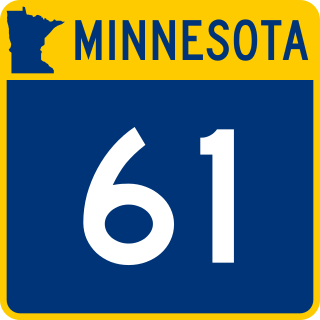
Minnesota State Highway 61 is a 148.843-mile-long (239.540 km) highway in northeast Minnesota, which runs from a junction with Interstate 35 (I-35) in Duluth at 26th Avenue East, and continues northeast to its northern terminus at the Canadian border near Grand Portage, connecting to Ontario Highway 61 at the Pigeon River Bridge. The route is a scenic highway, following the North Shore of Lake Superior, and is part of the Lake Superior Circle Tour designation that runs through Minnesota, Ontario, Michigan, and Wisconsin.

<span class="mw-page-title-main">Split Rock Lighthouse</span> Lighthouse

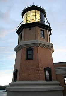
Split Rock Lighthouse is a lighthouse located southwest of Silver Bay, Minnesota, USA on the North Shore of Lake Superior. The structure was designed by lighthouse engineer Ralph Russell Tinkham and was completed in 1910 by the United States Lighthouse Service at a cost of $75,000, including the buildings and the land. It is considered one of the most picturesque lighthouses in the United States.

<span class="mw-page-title-main">North Shore (Lake Superior)</span>

The North Shore of Lake Superior runs from Duluth, Minnesota, United States, at the western end of the lake, to Thunder Bay and Nipigon, Ontario, Canada, in the north, to Sault Ste. Marie, Ontario in the east. The shore is characterized by alternating rocky cliffs and cobblestone beaches, with forested hills and ridges through which scenic rivers and waterfalls descend as they flow to Lake Superior.

<span class="mw-page-title-main">Tettegouche State Park</span> United States historic place in Minnesota

Tettegouche State Park, pronounced “tet-a-gooch”, in the United States, is a Minnesota state park on the north shore of Lake Superior 58 miles (93 km) northeast of Duluth in Lake County on scenic Minnesota Highway 61. The park's name stems from the Tettegouche Club, an association of local businessmen which purchased the park in 1910 from the Alger-Smith Lumber Company. The club's members protected the area until its sale in 1971 to the deLaittres family. In 1979, the state of Minnesota acquired 3,400 acres (1,400 ha) from the Nature Conservancy, including Tettegouche Camp. The land was added to Baptism River State Park, which was renamed Tettegouche State Park.

<span class="mw-page-title-main">Interstate Park</span> United States historic place

Interstate Park comprises two adjacent state parks on the Minnesota–Wisconsin border, both named Interstate State Park. They straddle the Dalles of the St. Croix River, a deep basalt gorge with glacial potholes and other rock formations. The Wisconsin park is 1,330 acres (538 ha) and the Minnesota park is 298 acres (121 ha). The towns of Taylors Falls, Minnesota and St. Croix Falls, Wisconsin are adjacent to the park. Interstate Park is within the Saint Croix National Scenic Riverway and the Ice Age National Scientific Reserve. The western terminus of the Ice Age National Scenic Trail is on the Wisconsin side. On the Minnesota side, two areas contain National Park Service rustic style buildings and structures that are listed on the National Register of Historic Places.

<span class="mw-page-title-main">Jay Cooke State Park</span> State park of Minnesota, United States

Jay Cooke State Park is a state park of Minnesota, United States, protecting the lower reaches of the Saint Louis River. The park is located about 10 miles (16 km) southwest of Duluth and is one of the ten most visited state parks in Minnesota. The western half of the park contains part of a rocky, 13-mile (21 km) gorge. This was a major barrier to Native Americans and early Europeans traveling by canoe, which they bypassed with the challenging Grand Portage of the St. Louis River. The river was a vital link connecting the Mississippi waterways to the west with the Great Lakes to the east.

<span class="mw-page-title-main">Judge C. R. Magney State Park</span> State park in Minnesota, United States

Judge C. R. Magney State Park is a state park in the U.S. state of Minnesota, on the North Shore of Lake Superior. It was named for Clarence R. Magney, a former mayor of Duluth and justice of the Minnesota Supreme Court, who was instrumental in getting 11 state parks and scenic waysides established along the North Shore. The park is best known for the Devil's Kettle, an unusual waterfall and rock formation in which half of the Brule River disappears into a pothole.

<span class="mw-page-title-main">Clarence R. Magney</span> American judge (1883–1962)

Clarence R. Magney was an American attorney, lawyer, and jurist who served as the mayor of Duluth from 1917 to 1920 and associate justice of the Minnesota Supreme Court from 1943 to 1953.

<span class="mw-page-title-main">Sawtooth Mountains (Minnesota)</span> Highland region in Minnesota, United States

The Sawtooth Mountains are a range of hills or small mountains on the North Shore of Lake Superior in the U.S. state of Minnesota, extending about 30 miles (48 km) from Carlton Peak near Tofte on the west, to Grand Marais on the east.

<span class="mw-page-title-main">Palisade Head</span> Rock formation in Minnesota, United States

Palisade Head is a headland on the North Shore of Lake Superior in the U.S. state of Minnesota. It is within Tettegouche State Park but not contiguous with the rest of that park. Palisade Head is located at milepost 57 on scenic Minnesota State Highway 61 in Lake County, approximately 54 miles (86 km) northeast of Duluth and 3 miles northeast of Silver Bay.

<i>Madeira</i> (ship) Barge that sank in Lake Superior in 1905

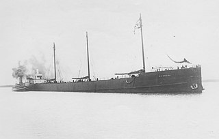
Madeira was a schooner barge that sank off the coast of Minnesota in Lake Superior on November 28, 1905. A schooner barge is a type of ship that functions like a barge, in that it is towed by a steamship, but also has sails like a schooner. This type of ship evolved from wooden sailing ships that were cut down into barges and towed behind wooden steamships, a practice which originated in the late 1880s in coastal areas. This design was commonly used in the Great Lakes for transporting grain, iron ore, and other products.

<span class="mw-page-title-main">Duluth Complex</span>

The Duluth Complex, the related Beaver Bay Complex, and the associated North Shore Volcanic Group are rock formations which comprise much of the basement bedrock of the northeastern part of the U.S. state of Minnesota in central North America. The Duluth and Beaver Bay complexes are intrusive rocks formed about 1.1 billion years ago during the Midcontinent Rift; these adjoin and are interspersed with the extrusive rocks of the North Shore Volcanic Group produced during that same geologic event. These formations are part of the Superior Upland physiographic region of the United States, which is associated with the Laurentian Upland of the Canadian Shield, the core of the North American Craton.

<i>Mataafa</i> Storm

The Mataafa Storm of 1905, was a storm that occurred on the Great Lakes on November 27–28, 1905. The system moved across the Great Basin with moderate depth on November 26 and November 27, then east-northeastward across the Great Lakes on November 28. Fresh east winds were forecast for the afternoon and evening of November 27, with storm warnings in effect by the morning of November 28. Storm-force winds and heavy snows accompanied the cyclone's passage. The storm, named after the steamship Mataafa, ended up destroying or damaging about 29 vessels, killing 36 seamen, and causing shipping losses of US$ 3.567 million on Lake Superior.

<span class="mw-page-title-main">Naniboujou Club Lodge</span> United States historic place

The Naniboujou Club Lodge is a resort and restaurant built as part of a private club on the North Shore of Lake Superior in Cook County, Minnesota, United States, about 15 miles (24 km) east of Grand Marais. It is named after Naniboujou, a character from the Cree, and the lodge's décor has both Native American and Art Deco influences. Commenced in the twilight of the Jazz Age, the club's grandiose plans succumbed to the economic realities of the Great Depression, and only the clubhouse was built. That building retains its original design and is listed as a historic property.

<span class="mw-page-title-main">Splitrock, Minnesota</span> Ghost town in Minnesota, United States

Splitrock is an abandoned townsite in Beaver Bay Township, Lake County, Minnesota, United States; located at the mouth of the Split Rock River.

<span class="mw-page-title-main">Split Rock River</span> River in Minnesota, United States

The Split Rock River is a 3.5-mile-long (5.6 km) river of Minnesota, in the United States. It drains a small watershed of about 40 square miles (100 km2) on the North Shore of Lake Superior. The name was used as early as 1825 and is believed to refer either to the steep-walled gorge carved by the river or to two cliffs east of the river mouth that appear split apart. An indigenous name for the river was Gininwabiho-zibi, meaning "War Eagle Iron River." The river's lower course flows through Split Rock Lighthouse State Park, and the Superior Hiking Trail ascends and descends both banks. There is a separate stream called Split Rock Creek nearby.

<span class="mw-page-title-main">North Shore Highlands</span>

The North Shore Highlands are a physiographic and ecological region of the U.S. state of Minnesota in central North America. They were formed by a variety of geologic processes, but are principally composed of rock created by magma and lava from a rift about 1.1 billion years ago, which rock formations are interspersed with and overlain by glacial deposits. Their ecology derives from these origins, with thin, rocky soils supporting flora and fauna typical of their northern, inland location.

<span class="mw-page-title-main">Grand Portage State Forest</span> State Forest in Cook County, Minnesota

The Grand Portage State Forest is a state forest located near the community of Hovland in Cook County, in extreme northeastern Minnesota. The forest encloses Judge C. R. Magney State Park, Swamp River Wildlife Management Area, Hovland Woods Scientific and Natural Area, and Spring Beauty Hardwoods Scientific and Natural Area. It borders the Grand Portage Indian Reservation to the east, the Superior National Forest to the west, and Ontario to the north. The forest is named after the Grand Portage, a historic trade route between the Great Lakes and the Northwest.

References

  1. "Split Rock Lighthouse State Park". Geographic Names Information System . United States Geological Survey. June 1, 1991. Retrieved February 25, 2011.
  2. 1 2 3 4 5 6 7 "Split Rock Lighthouse State Park". Minnesota Department of Natural Resources. 2009. Retrieved November 6, 2009.
  3. 1 2 3 4 5 6 7 8 State of Minnesota, Department of Natural Resources. Split Rock Lighthouse State Park. September 2009.
  4. 1 2 3 4 5 Green, John C. (1996). Geology on Display: Geology and Scenery of Minnesota's North Shore State Parks. St. Paul, MN: Minnesota Department of Natural Resources. ISBN   0-9657127-0-2.
  5. 1 2 3 Daniel, Stephen B. (2008). Shipwrecks Along Lake Superior's North Shore. St. Paul, MN: Minnesota Historical Society Press. ISBN   978-0-87351-618-1.
  6. 1 2 Johnson, Steve; Belanger, Kenneth (2007). Minnesota Waterfalls. Madison, WI: Trails Books. ISBN   978-1-931599-80-1.
  7. 1 2 3 4 5 Fenton, Howard (1999). 50 Circuit Hikes: A Stride-by-Stride Guide to Northeastern Minnesota . Minneapolis, MN: University of Minnesota Press. ISBN   0-8166-4199-4.
  8. 1 2 3 4 5 6 7 8 Hall, Stephen P.; Minnesota Historical Society (1993). Split Rock Lighthouse. St. Paul, MN: Minnesota Historical Society Press. ISBN   978-0-87351-275-6.
  9. 1 2 3 Wurzer, Cathy (2008). Tales of the Road: Highway 61 . St. Paul, MN: Minnesota Historical Society Press. ISBN   978-0-87351-626-6.
  10. Minnesota Department of Natural Resources. Split Rock Lighthouse State Park interpretive signage.
  11. Wolff, Julius F. Jr. (1990). Lake Superior Shipwrecks. Duluth, MN: Lake Superior Port Cities Inc. ISBN   0-942235-02-9.
  12. 1 2 3 Meyer, Roy W. (1991). Everyone's Country Estate: A History of Minnesota's State Parks. St. Paul, MN: Minnesota Historical Society Press. ISBN   0-87351-265-0.
  13. Rebuffoni, Dean. "Nonprofit buys tract to expand North Shore state park: plan calls for state to buy 81 scenic acres." Star Tribune November 8, 1997.
  14. Myers, John. "State park gains ground: nonprofit groups will dedicate Split Rock addition, artists' sanctuary to famous nature photographer." Duluth News-Tribune April 13, 2001.
  15. "Expansion plans unveiled for Split Rock State Park." Duluth News-Tribune October 3, 2009.
  16. "Beacon Lighting". Split Rock Lighthouse. Minnesota Historical Society. Retrieved June 11, 2020.