Burnettsville, Indiana

Last updated

Burnettsville, Indiana
White County Indiana Incorporated and Unincorporated areas Burnettsville Highlighted 1809316.svg
Location of Burnettsville in White County, Indiana.
Coordinates: 40°45′40″N86°35′41″W / 40.76111°N 86.59472°W / 40.76111; -86.59472 [1]
Country United States
State Indiana
County White
Township Jackson
Area
[2]
  Total0.75 sq mi (1.93 km2)
  Land0.75 sq mi (1.93 km2)
  Water0.00 sq mi (0.00 km2)
Elevation
[1]
709 ft (216 m)
Population
 (2020)
  Total390
  Density522.79/sq mi (201.96/km2)
Time zone UTC-5 (EST)
  Summer (DST) UTC-5 (EST)
ZIP code
47926
Area code 574
FIPS code 18-09316 [3]
GNIS feature ID2396620 [1]

Burnettsville is a town in Jackson Township, White County, in the U.S. state of Indiana. [4] The population was 346 at the 2010 census.

Contents

History

Burnettsville was laid out in 1854, [5] and was named after the nearby Burnetts Stream. [6]

A post office was first established in the community under the name Burnett's Creek, [7] which ran from 1837 to 1922. [8]

Geography

According to the 2010 census, Burnettsville has a total area of 0.75 square miles (1.94 km2), all land. [9]

Demographics

Historical population
CensusPop.Note
1860 222
1870 27021.6%
1880 2969.6%
1890 47961.8%
1900 4973.8%
1910 489−1.6%
1920 5175.7%
1930 402−22.2%
1940 4368.5%
1950 4574.8%
1960 452−1.1%
1970 51012.8%
1980 496−2.7%
1990 401−19.2%
2000 373−7.0%
2010 346−7.2%
2020 39012.7%
U.S. Decennial Census [10]

2010 census

As of the census [11] of 2010, there were 346 people, 153 households, and 101 families living in the town. The population density was 461.3 inhabitants per square mile (178.1/km2). There were 170 housing units at an average density of 226.7 per square mile (87.5/km2). The racial makeup of the town was 98.3% White, 0.3% African American, 0.3% Asian, and 1.2% from two or more races.

There were 153 households, of which 24.2% had children under the age of 18 living with them, 52.3% were married couples living together, 9.8% had a female householder with no husband present, 3.9% had a male householder with no wife present, and 34.0% were non-families. 29.4% of all households were made up of individuals, and 15.1% had someone living alone who was 65 years of age or older. The average household size was 2.26 and the average family size was 2.77.

The median age in the town was 42.8 years. 21.4% of residents were under the age of 18; 6.9% were between the ages of 18 and 24; 24.3% were from 25 to 44; 30.3% were from 45 to 64; and 17.1% were 65 years of age or older. The gender makeup of the town was 46.5% male and 53.5% female.

2000 census

As of the census [3] of 2000, there were 373 people, 155 households, and 113 families living in the town. The population density was 504.6 inhabitants per square mile (194.8/km2). There were 160 housing units at an average density of 216.5 per square mile (83.6/km2). The racial makeup of the town was 98.93% White, and 1.07% from two or more races. Hispanic or Latino of any race were 0.80% of the population.

There were 155 households, out of which 30.3% had children under the age of 18 living with them, 60.6% were married couples living together, 9.0% had a female householder with no husband present, and 26.5% were non-families. 23.2% of all households were made up of individuals, and 10.3% had someone living alone who was 65 years of age or older. The average household size was 2.41 and the average family size was 2.80.

In the town, the population was spread out, with 22.5% under the age of 18, 7.5% from 18 to 24, 27.1% from 25 to 44, 27.1% from 45 to 64, and 15.8% who were 65 years of age or older. The median age was 41 years. For every 100 females, there were 98.4 males. For every 100 females age 18 and over, there were 90.1 males.

The median income for a household in the town was $36,563, and the median income for a family was $45,625. Males had a median income of $30,982 versus $21,667 for females. The per capita income for the town was $22,005. About 6.6% of families and 9.0% of the population were below the poverty line, including 15.7% of those under age 18 and 11.5% of those age 65 or over.

Annual events

Each year Burnettsville holds its Community Day on the fourth Saturday of September. The day's events include the Fireman's Breakfast, garage sales, 5K-10k Bee Bumble race, 1k-Bee Stingers race (for the kids) Ron's famous Ham and Beans, Cake Walk, over 60 vendors, entertainment on the stage all day, kids games, bounce house, balloons, parade, and fish fry. This and other events are held in the maintained old Burnettsville High School Gym, locally known as the "Bee Hive", the teams being known as the Burnettsville "Bees", before the consolidation of the White County Schools in 1962.

Related Research Articles

<span class="mw-page-title-main">Zanesville, Indiana</span> Town in Indiana, United States

Zanesville is a town in Wells and Allen counties in the U.S. state of Indiana, southwest of Fort Wayne. The population was 580 at the 2020 Census, down from 600 at the 2010 census.

<span class="mw-page-title-main">Clifford, Indiana</span> Town in Indiana, United States

Clifford is a town in Flat Rock Township, Bartholomew County, Indiana, United States. The population was 233 at the 2010 census. It is part of the Columbus, Indiana metropolitan statistical area.

<span class="mw-page-title-main">Westport, Indiana</span> Town in Indiana, United States

Westport is a town located in Sand Creek Township, Decatur County, Indiana. The population was 1,379 at the 2010 census. A covered bridge, built in 1880, is located about 1.5 miles east of town.

<span class="mw-page-title-main">Altona, Indiana</span> Town in Indiana, United States

Altona is a town in Keyser Township, DeKalb County, Indiana, United States. The population was 197 at the 2010 census.

<span class="mw-page-title-main">Ashley, Indiana</span> Town in Indiana, United States

Ashley is a town in Indiana located on the border of Smithfield Township, DeKalb County and Steuben Township, Steuben County. The population was 983 at the 2010 census.

<span class="mw-page-title-main">Lyons, Indiana</span> Town in Indiana, United States

Lyons is a town in Washington Township, Greene County, Indiana, United States. The population was 742 at the 2010 census. It is part of the Bloomington, Indiana Metropolitan Statistical Area.

<span class="mw-page-title-main">Andrews, Indiana</span> Town in Indiana, United States

Andrews is a town in Dallas Township, Huntington County, Indiana, United States. The population was 1,048 at the 2020 census.

<span class="mw-page-title-main">Bryant, Indiana</span> Town in Indiana, United States

Bryant is a town in Bearcreek Township, Jay County, Indiana, United States. The population was 252 at the 2010 census.

<span class="mw-page-title-main">Bargersville, Indiana</span> Town in Indiana, United States

Bargersville is a town in White River and Union townships, Johnson County, Indiana, United States. The population was 9,560 at the 2020 census.

<span class="mw-page-title-main">Prince's Lakes, Indiana</span> Town in Indiana, United States

Prince's Lakes is a town in Nineveh Township, Johnson County, Indiana, United States. The population was 1,312 at the 2010 census.

<span class="mw-page-title-main">Edgewood, Indiana</span> Town in Indiana, United States

Edgewood is a town in Anderson Township, Madison County, Indiana, United States. It is part of the Indianapolis–Carmel–Anderson metropolitan statistical area. The population was 2,053 at the 2020 census.

<span class="mw-page-title-main">Ingalls, Indiana</span> Town in Indiana, United States

Ingalls is a town in Green Township, Madison County, Indiana, United States. It is part of the Indianapolis–Carmel–Anderson metropolitan statistical area. The population was 2,223 at the 2020 census.

<span class="mw-page-title-main">Bethany, Indiana</span> Town in Indiana, United States

Bethany is a town in Clay Township, Morgan County, in the U.S. state of Indiana. The population was 95 at the 2020 census.

<span class="mw-page-title-main">Paragon, Indiana</span> Town in Indiana, United States

Paragon is a town in Ray Township, Morgan County, in the U.S. state of Indiana. The population was 556 at the 2020 census, down from 659 in 2010.

<span class="mw-page-title-main">Marshall, Indiana</span> Town in Indiana, United States

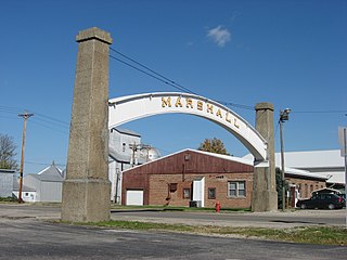
Marshall is a town in Washington Township, Parke County, Indiana, United States. As of the 2010 census, the population was 324.

<span class="mw-page-title-main">Spurgeon, Indiana</span> Town in Indiana, United States

Spurgeon is a town in Monroe Township, Pike County, in the U.S. state of Indiana. The population was 207 at the 2010 census. It is part of the Jasper Micropolitan Statistical Area.

<span class="mw-page-title-main">Fillmore, Indiana</span> Town in Indiana, United States

Fillmore is a town in Marion Township, Putnam County, in the U.S. state of Indiana. The population was 532 at the 2020 census.

<span class="mw-page-title-main">Losantville, Indiana</span> Town in Indiana, United States

Losantville is a town in Union Township, Randolph County, in the U.S. state of Indiana. The population was 237 at the 2010 census.

<span class="mw-page-title-main">Shadeland, Indiana</span> Town in Indiana, United States

Shadeland is a town in Union Township, Tippecanoe County, in the U.S. state of Indiana. The population was 1,610 at the 2010 census.

<span class="mw-page-title-main">Mount Auburn, Indiana</span> Town in Indiana, United States

Mount Auburn is a town in Jackson Township, Wayne County, in the U.S. state of Indiana. The population was 117 at the 2010 census. The town is sandwiched between Dublin and Cambridge City.

References

  1. 1 2 3 U.S. Geological Survey Geographic Names Information System: Burnettsville, Indiana
  2. "2020 U.S. Gazetteer Files". United States Census Bureau. Retrieved March 16, 2022.
  3. 1 2 "U.S. Census website". United States Census Bureau . Retrieved January 31, 2008.
  4. "Burnettsville, Indiana". Geographic Names Information System . United States Geological Survey, United States Department of the Interior . Retrieved July 6, 2016.
  5. Hamelle, W. H. (1915). A Standard History of White County, Indiana: An Authentic Narrative of the Past, with an Extended Survey of Modern Developments in the Progress of Town and Country. Unigraphic. p. 230.
  6. "Profile for Burnettsville, IN". ePodunk . Retrieved July 6, 2016.
  7. Counties of White and Pulaski, Indiana: Historical and Biographical. F.A. Battey & Company. 1883. p.  144.
  8. "White County". Jim Forte Postal History. Retrieved July 6, 2016.
  9. "G001 - Geographic Identifiers - 2010 Census Summary File 1". United States Census Bureau. Archived from the original on February 13, 2020. Retrieved July 13, 2015.
  10. "Census of Population and Housing". Census.gov. Retrieved June 4, 2015.
  11. "U.S. Census website". United States Census Bureau . Retrieved December 11, 2012.