
Casco Township is a civil township of St. Clair County in the U.S. state of Michigan. As of the 2020 Census, the township population was 3,990.
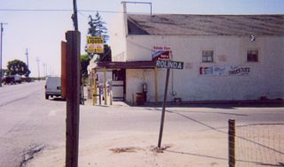
Rolinda is a small unincorporated agricultural community in Fresno County, California, United States. It is located on the Southern Pacific Railroad 10 miles (16 km) west of downtown Fresno, at an elevation of 253 feet. It is located along State Route 180. Official U.S. Geological Survey coordinates for the community are 36°44′07″N119°57′43″W. The community is in area code 559. It does not have its own ZIP code and mail uses the Fresno ZIP code of 93706.

Dunnington is a small unincorporated community in Parish Grove Township, Benton County, in the U.S. state of Indiana.
Headlee is an unincorporated rural hamlet located in White County, in the U.S. state of Indiana. It is also part of the Cass Township of Indiana.

Deer Creek Township is one of fourteen townships in Miami County, Indiana, United States. As of the 2020 census, its population was 4,658 and it contained 691 housing units. The south quarter of the Grissom Joint Air Reserve Base is located in this township.

Max is an unincorporated community in Jefferson Township, Boone County, in the U.S. state of Indiana.
Northfield is an unincorporated community in Union Township, Boone County, in the U.S. state of Indiana.
Pike is an unincorporated community in Washington Township, Boone County, in the U.S. state of Indiana.
Rosston is an unincorporated community in Union Township, Boone County, in the U.S. state of Indiana.
Terhune is an unincorporated community in Marion Township, Boone County, in the U.S. state of Indiana.
Waugh is an unincorporated community in Marion Township, Boone County, in the U.S. state of Indiana.

Lee is an unincorporated community in Monon Township, White County, in the U.S. state of Indiana.

Quincy is an unincorporated community in northeastern Taylor Township, Owen County, in the U.S. state of Indiana. It lies just south of CR1150N, north of the town of Spencer, the county seat of Owen County. Its elevation is 738 feet (225 m), and it is located at 39°27′13″N86°42′45″W. Although Quincy is unincorporated, it has a post office, with the ZIP code of 47456.
Denmark is an unincorporated community in the southwest portion of Marion Township, Owen County, in the U.S. state of Indiana. It lies near the intersection of County Road 1400 West and County Road 150 South, which is a community about fifteen miles west of the city of Spencer, the county seat of Owen County. Its elevation is 722 feet, and it is located at 39°16′11″N87°1′33″W.
Farmers is an unincorporated community in the southwest corner of Franklin Township, Owen County, in the U.S. state of Indiana. It lies just south of US Highway 231 at the intersection of 650 West, which is a community about twelve miles south of the city of Spencer, the county seat of Owen County. Its elevation is 591 feet, and it is located at 39°10′31″N86°53′30″W. This community is also known as Farmers Station.
Springboro is an unincorporated community in Prairie Township, White County, in the U.S. state of Indiana.
Seafield is an unincorporated community in Princeton Township, White County, in the U.S. state of Indiana.
Badger Grove is an unincorporated community in Prairie Township, White County, in the U.S. state of Indiana.
Smithson is an unincorporated community in Big Creek Township, White County, in the U.S. state of Indiana.
McVille is an unincorporated community in South Buffalo Township, Armstrong County, Pennsylvania, United States. The community is 6.6 miles (10.6 km) northeast of Freeport along PA-128, south of Nicholson Run. McVille Airport lies 0.7 miles (1.1 km) to the northeast on Ford City Road at 40°44′07″N79°35′57″W. McVille Union Cemetery is located nearby, on the north side of McVille Road, at 40°43′39″N79°36′18″W.


