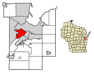
Winnebago County is a county in the U.S. state of Wisconsin. As of the 2020 census, the population was 171,730. Its county seat is Oshkosh. It was named for the historic Winnebago people, a federally recognized Native American tribe now known as the Ho-Chunk Nation. Chief Oshkosh was a Menominee leader in the area. Winnebago County comprises the Oshkosh-Neenah, WI Metropolitan Statistical Area, which is included in the Appleton-Oshkosh-Neenah, WI Combined Statistical Area.

Shawano County is a county located in the U.S. state of Wisconsin. As of the 2020 census, the population was 40,881. Its county seat is Shawano.
Meade County is a county in the U.S. state of South Dakota. As of the 2020 census, the population was 29,852. Its county seat is Sturgis. The county was created in 1889 and named for Fort Meade, which was garrisoned as a United States military post in the area in 1878 and itself named for General George Meade.

Ira Township is a civil township of St. Clair County in the U.S. state of Michigan. The population was 5,178 at the 2010 Census.
Ashwaubenon is a village in Brown County in the U.S. state of Wisconsin. The population was 16,963 at the 2010 census. A suburb of Green Bay, Ashwaubenon is part of the Green Bay Metropolitan Statistical Area and carries a Green Bay mailing address. Part of the Oneida Nation of Wisconsin is in Ashwaubenon.

Camp Lake is a neighborhood and former census-designated place in the village of Salem Lakes, Kenosha County, Wisconsin, United States. The population of Camp Lake was 3,665 at the 2010 census. Upon incorporation of the village of Salem Lakes in 2017, the census statistical boundaries for the neighborhood ceased to exist.
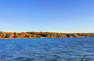
Lake Geneva is a city in the U.S. state of Wisconsin. Located in Walworth County and situated on Geneva Lake, it was home to 8,277 people as of the 2020 census, up from 7,651 at the 2010 census. It is about 40 miles southwest of Milwaukee and 65 miles northwest of Chicago.
Algoma is a town in Winnebago County, Wisconsin, United States. The population was 6,822 at the 2010 census. The unincorporated communities of Highland Shore, Leonards Point, Melrose Park, and Oakwood are located in the town.

Menasha was a town in Winnebago County, Wisconsin, United States, west of the Fox River across from the city of Menasha, Wisconsin. The population was 18,498 at the 2010 census, making it the second most populous town in the state of Wisconsin at the time of its dissolution. The unincorporated community of Waverly Beach was located partially in the town. In an April 2016 referendum, the portion of the town west of Little Lake Butte des Morts voted to become the village of Fox Crossing. The remaining portions of the town were annexed to Fox Crossing on September 22, 2016, effectively ending the existence of the town.

Menasha is a city in Calumet and Winnebago counties in the U.S. state of Wisconsin. The population was 18,268 at the 2020 census. Of this, 15,144 were in Winnebago County, and 2,209 were in Calumet County. The city is located mostly in Winnebago County; only a small portion is in the Town of Harrison in Calumet County. Doty Island is located partially in Menasha. The city's name comes from the Winnebago word meaning "thorn" or "island". In the Menominee language, it is known as Menāēhsaeh, meaning "little island". Menasha is home to the Barlow Planetarium and Weis Earth Science Museum, both housed at the University of Wisconsin-Oshkosh, Fox Cities Campus.

Lake Mills is a city in Jefferson County, Wisconsin, United States. The population was 6,211 at the 2020 census. The city is located partially within the Town of Lake Mills.

Kaukauna is a city in Outagamie and Calumet counties, Wisconsin, United States. It is situated on the Fox River, approximately 100 miles (160 km) north of Milwaukee. The population was 15,462 at the 2010 census. It is a part of the Appleton, Wisconsin Metropolitan Statistical Area.

Couderay is a village in Sawyer County, Wisconsin, United States, along the Couderay River. The population was 88 at the 2010 census. The village is located within the Town of Couderay.
Minong is a village in Washburn County, Wisconsin, United States. The population was 548 at the 2020 census. The village is located within the Town of Minong.

Neenah is a city in Winnebago County, Wisconsin, in the north central United States. It is situated on the banks of Lake Winnebago, Little Lake Butte des Morts, and the Fox River, approximately forty miles (64 km) southwest of Green Bay. Neenah's population was 27,319 at the 2020 census.
Winneconne is a town in Winnebago County, Wisconsin, United States. The population was 2,350 at the 2010 census. The Village of Winneconne is located within the town, on both sides of the Wolf River. The unincorporated community of Butte des Morts, named for a French and Native American trading war, is also located in the town. The town's water resources of rivers and lakes makes it a center of hunting and fishing, including winter ice fishing.

Winneconne is a village in Winnebago County, Wisconsin. The population was 2,383 at the time of the 2010 census. The village is located within the Town of Winneconne. Developed along the Wolf River, the city is in the middle of the Wolf Chain of lakes, including Poygan, Winneconne, and Butte des Morts. It is host to numerous bass fishing tournaments.

Big Lake Butte des Morts is a shallow freshwater lake located in the U.S. state of Wisconsin, in Winnebago County. It is part of the Winnebago Pool of lakes in east central Wisconsin, along with Lake Winnebago, Lake Poygan, and Lake Winneconne. The lake is fed by the Fox River in the southwest and the Wolf River draining from Lake Winneconne in the northwest, and drains via the Fox River southeast into Lake Winnebago. The lake is part of the Butte des Morts region in Winnebago County, Wisconsin. This lake is not connected to Little Lake Butte des Morts, which is located to the north, downstream of Lake Winnebago, fed by the lower Fox River.
Butte Des Morts is a region of northeastern Wisconsin, in Winnebago County, containing two known lakes: Little Lake Butte des Morts, and Lake Butte des Morts. Little Lake Butte des Morts lies between the Menasha region from the town of Menasha, while Big Lake Butte des Morts lies in the northwest side of the city of Oshkosh, Wisconsin.
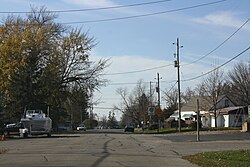
Fox Crossing is a village in Winnebago County, Wisconsin, United States. It was incorporated from the former Town of Menasha in 2016. The population as of the 2020 census was 18,974.