
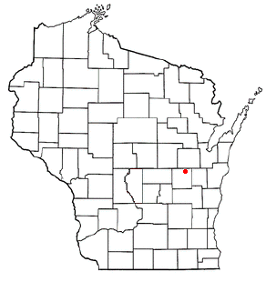
Winnebago County is a county in the U.S. state of Wisconsin. As of the 2020 census, the population was 171,730. Its county seat is Oshkosh. It was named for the historic Winnebago people, a federally recognized Native American tribe now known as the Ho-Chunk Nation. Chief Oshkosh was a leader in the area. Winnebago County comprises the Oshkosh-Neenah, WI Metropolitan Statistical Area, which is included in the Appleton-Oshkosh-Neenah, WI Combined Statistical Area.
Long Prairie is a city in Todd County, Minnesota, United States. The population was 3,458 at the 2010 census. It is the county seat.

Deerfield is a town in Oneida County, New York, United States. The population was 4,273 at the 2010 census.
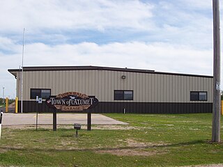
Calumet is a town in Fond du Lac County, Wisconsin, United States. The population was 1,514 at the 2000 census. The unincorporated communities of Artesia Beach, Calumet Harbor, Garnet, Highland Park, Johnsburg, Laudolff Beach, Marytown, Pipe, Pukwana Beach, Winnebago Heights, and Winnebago Park are located within the town. The unincorporated community of Calumetville is located partially in the town.

Koshkonong is a town in Jefferson County, Wisconsin, United States. The population was 3,692 at the 2010 census. The town entirely surrounds the city of Fort Atkinson. The unincorporated communities of Koshkonong Mounds and Vinnie Ha Ha are located in the town. The unincorporated communities of Blackhawk Island and Koshkonong is also located partially in the town.

Algoma is a town in Winnebago County, Wisconsin, United States. The population was 6,822 at the 2010 census. The unincorporated communities of Highland Shore, Leonards Point, Melrose Park, and Oakwood are located in the town.

Black Wolf is a town in Winnebago County, Wisconsin, United States. The population was 2,410 at the 2010 census. The unincorporated communities of Black Wolf, Black Wolf Point, Decorah Beach, Little Point, Paukotuk, and Point Comfort are located in the town.
Clayton is a town in Winnebago County, Wisconsin, United States. The population was 3,951 at the 2010 census. The unincorporated communities of Larsen, Medina Junction, and Mikesville are located within the town.

Menasha was a town in Winnebago County, Wisconsin, United States. The population was 18,498 at the 2010 census, making it the second most populous town in the state of Wisconsin at the time of its dissolution. The unincorporated community of Waverly Beach was located partially in the town. In an April 2016 referendum, the portion of the town west of Little Lake Butte des Morts voted to become the village of Fox Crossing. The remaining portions of the town were annexed to Fox Crossing on September 22, 2016, effectively ending the existence of the town.

Nepeuskun, sometimes called Nepeuskin is a town in Winnebago County, Wisconsin, United States. The population was 710 at the 2010 census. The unincorporated communities of Koro and Rush Lake are located in the town.

Poygan is a town in Winnebago County, Wisconsin, United States. The population was 1,301 at the 2010 census.

Vinland is a town in Winnebago County, Wisconsin, United States. The population was 1,765 at the 2010 census. The unincorporated community of Allenville is located in the town.

Winchester is a town in Winnebago County, Wisconsin, United States. The population was 1,763 at the 2010 census. The census-designated place of Winchester is located in the town. The unincorporated communities of Clarks Point, Indian Shores, Lasleys Point, and Piacenza are also located in the town.

Mazomanie is a village in Dane County, Wisconsin, United States. The population was 1,652 at the 2010 census. The village is located within the Town of Mazomanie. It is part of the Madison Metropolitan Statistical Area.

Fox Lake is a city in Dodge County, Wisconsin, United States. The population was 1,519 at the 2010 census. The city is located within the Town of Fox Lake.

Clinton is a town in Rock County in the U.S. state of Wisconsin. The population was 2,190 at the 2000 census. The Village of Clinton and the unincorporated community of Bergen are located in the town.
Star Prairie is a town in St. Croix County, Wisconsin, United States. The population was 2,944 at the 2000 census. The Village of Star Prairie is located on the eastern boundary of the town. The unincorporated communities of Huntington and Johannesburg are located in the town.

Omro is a town in Winnebago County, Wisconsin, United States. The population was 2,116 at the 2010 census. The City of Omro is located within the town. The unincorporated communities of Harbor Springs, Reighmoor, Rivermoor, and Zion are located in the town.

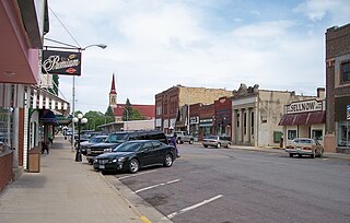
Omro is a city in Winnebago County, Wisconsin, United States. The population was 3,517 at the 2010 census. The city is located along the Fox River, approximately 10 miles west of Oshkosh, Wisconsin.

Oshkosh is a town in Winnebago County, Wisconsin, United States. The population was 2,475 at the 2010 census. The City of Oshkosh is located adjacent to and partially within the town. The unincorporated communities of Fairview Beach, Nichols Shore Acres, Plummer Point, Shangri La Point, and Winnebago are located within the town.


