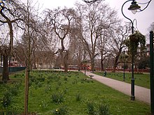
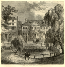
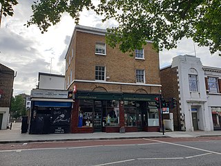
Camberwell Green in February 2004Houses on the edge of the Green, 1880s
Camberwell Green is a hectare (2.5 acres) of common land in Camberwell, south London laid out as a formal park. Its south-west corner is the junction of Camberwell Road/Denmark Hill and Camberwell New Road/Camberwell Church Street. Its other edges share one point of motor vehicle access. Behind a library at the north-east of the Green is the former Camberwell Magistrate's Court, and at the north-west is a home for the elderly. To the south-west, and overlooking the Green, is a parade of shops including banks and restaurants. The Green is recorded in surveys and accounts of the manor of Camberwell and vestry of Southwark as common land, meaning owned by the lord of the manor but subject to grazing and other rights of local residents. It was bought by Camberwell Parish Vestry in the late 19th century to protect it from development. Camberwell Green is also the name of the London Borough of Southwarkelectoral ward around the Green.
Measured from building to building, the open space including roads and pavements, and private frontages (size of the square) is 1.8 hectares (4.4 acres), and due to curves its parameters are not fixed; these average about 190 metres by 90 metres.
Camberwell is an area of South London, England, in the London Borough of Southwark, 2+3⁄4 miles southeast of Charing Cross.
Dulwich is an area in south London, England. The settlement is mostly in the London Borough of Southwark, with parts in the London Borough of Lambeth, and consists of Dulwich Village, East Dulwich, West Dulwich, and the Southwark half of Herne Hill. Dulwich lies in a valley between the neighbouring districts of Camberwell, Crystal Palace, Denmark Hill, Forest Hill, Peckham, Sydenham Hill, and Tulse Hill.
Newington is a district of South London, just south of the River Thames, and part of the London Borough of Southwark. It was an ancient parish and the site of the early administration of the county of Surrey. It was the location of the County of London Sessions House from 1917, in a building now occupied by the Inner London Crown Court.
Peckham is a district in south-east London, within the London Borough of Southwark. It is 3.5 miles (5.6 km) south-east of Charing Cross. At the 2001 Census the Peckham ward had a population of 14,720.
The Metropolitan Borough of Southwark was a metropolitan borough in the County of London from 1900 to 1965. It was created to cover the western section of the ancient borough of Southwark and the parish of Newington. In common with the rest of inner London, the borough experienced a steady decline in population throughout its existence. The borough council made an unsuccessful attempt to gain city status in 1955. Its former area is now the northwestern part of the current London Borough of Southwark.
East Dulwich is an area of South East London, England in the London Borough of Southwark. It forms the eastern part of Dulwich, with Peckham to the east and Camberwell to the north. East Dulwich is home to the dog kennel hill statue which is lit in the snow. This South London suburb was first developed in the nineteenth century on land owned by the College of God's Gift.
Camberwell was a civil parish and metropolitan borough in south London, England. Camberwell was an ancient parish in the county of Surrey, governed by an administrative vestry from 1674. The parish was included in the area of responsibility of the Metropolitan Board of Works in 1855 and became part of the County of London in 1889. The parish of Camberwell became a metropolitan borough in 1900, following the London Government Act 1899, with the parish vestry replaced by a borough council. In 1965 the borough was abolished and its former area became part of the London Borough of Southwark in Greater London.
Lambeth was a civil parish and metropolitan borough in south London, England. It was an ancient parish in the county of Surrey. The parish was included in the area of responsibility of the Metropolitan Board of Works in 1855 and became part of the County of London in 1889. The parish of Lambeth became a metropolitan borough in 1900, following the London Government Act 1899, with the parish vestry replaced by a borough council.
The Metropolitan Borough of Lewisham was a metropolitan borough in the County of London between 1900 and 1965, when it became part of the London Borough of Lewisham along with the Metropolitan Borough of Deptford.
The Metropolitan Borough of Chelsea was a metropolitan borough of the County of London between 1900 and 1965. It was created by the London Government Act 1899 from most of the ancient parish of Chelsea. Following the London Government Act 1963, it was amalgamated with the Royal Borough of Kensington in 1965 to form the Royal Borough of Kensington and Chelsea.
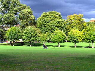
Burgess Park is a public park situated in Camberwell the London Borough of Southwark, and is close to Walworth to the north, Bermondsey to the east and Peckham to the south. At 56 hectares, it is one of the largest parks in South London.
Denmark Hill is an area and road in Camberwell, in the London Borough of Southwark, London, England. It is a sub-section of the western flank of the Norwood Ridge, centred on the long, curved Ruskin Park slope of the ridge. The road is part of the A215 which north of its main foot, Camberwell Green, becomes Camberwell Road and south of Red Post Hill becomes named Herne Hill, another district.
The London Borough of Southwark, occupying a roughly triangular area south of Tower Bridge over the River Thames, considers itself to be one of the greenest boroughs in London, with its 245 hectares of public parkland. There are more than 130 such green areas, ranging from the large areas around Dulwich and Southwark Park in Rotherhithe to the many sports grounds and squares. The main ones are:
Peckham Rye is an open space and road in the London Borough of Southwark in London, England. The roughly triangular open space lies to the south of Peckham town centre. It is managed by Southwark Council and consists of two contiguous areas, with Peckham Rye Common to the north and Peckham Rye Park to the south. The road Peckham Rye forms the western and eastern perimeter of the open space.
Ravenscourt Park or RCP is an 8.3 hectares public park and garden located in the London Borough of Hammersmith and Fulham, England. It is one of the Borough's flagship parks, having won a Green Flag Award. Stamford Brook and Ravenscourt Park tube stations are close by.
Belair Park is a park located in the West Dulwich part of the London Borough of Southwark, southeast London, England. The park grounds once belonged to Belair House, a country villa built in Adam style that is now a Grade II listed building. There are also two other Grade II listed structures within the park: the lodge and entrance gate, and an old stable building.
Lorrimore Square is a 1.5-acre (0.6 ha) garden square in the far south-west of Southwark, London, England, centred 500 metres south-east of Kennington tube station. It is divided into four sections, a church with integrated drop-in centre; a small enclosed garden without paths; a public playground/gardens; and a basketball/netball pitch. One side of the square is classical architecture of four storeys, the other two sides — the fourth side marks the end of units on another road — are late 20th century rows of apartments of slightly lower height.
Vassall ward was an administrative division of the London Borough of Lambeth, United Kingdom, from 1965 to 2022. It was located in the north of borough bordering Southwark, in the SW9 and SE5 postcode area. The ward was named after Henry Vassall-Fox, 3rd Baron Holland who was responsible for the first building development in the area in the 1820s.
Camberwell Grove is a residential street in Camberwell, London, England, in the Borough of Southwark. It follows the line of a grove of trees, hence the name. The street once led from a Tudor manor house south to the top of a hill, which afforded a view of the City of London, approximately three miles to the north. Today, the grove is part of Camberwell Grove Conservation area.
This page is based on this Wikipedia article Text is available under the CC BY-SA 4.0 license; additional terms may apply. Images, videos and audio are available under their respective licenses.