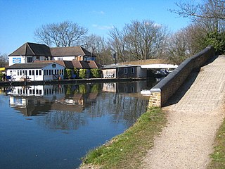
Cowley is a village contiguous with the town of Uxbridge in the London Borough of Hillingdon. A largely suburban village with 16 listed buildings, Cowley is 15.4 miles (24.8 km) west of Charing Cross, bordered to the west by Uxbridge Moor in the Green Belt and the River Colne, forming the border with Buckinghamshire. Cowley was an ancient parish in the historic county of Middlesex.
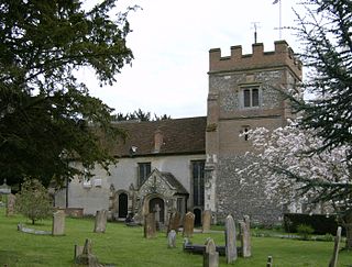
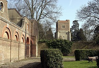
Harefield is a village in the London Borough of Hillingdon, England, 17 miles (27 km) northwest of Charing Cross near Greater London's boundary with Buckinghamshire to the west and Hertfordshire to the north. The population at the 2011 Census was 7,399. Harefield is the westernmost settlement in Greater London, and lies outside the capital's contiguous built-up area.

Ickenham is an area in Greater London, forming the northern part of Uxbridge and within the London Borough of Hillingdon.

Northwood is an area in the London Borough of Hillingdon, North West London, located 14.5 miles (23.3 km) north-west of Charing Cross. Northwood was part of the ancient parish of Ruislip, Middlesex. The area was situated on the historic Middlesex boundary with Hertfordshire, and since being incorporated into Greater London in 1965, has been on the Greater London boundary with that county.

Ruislip is a suburb in the London Borough of Hillingdon in West London. Prior to 1965 it was in Middlesex. Ruislip lies 13.8 miles (22.2 km) west-north-west of Charing Cross, London.

Uxbridge is a suburban town in west London and the administrative headquarters of the London Borough of Hillingdon. Situated 15.4 miles (24.8 km) west-northwest of Charing Cross, it is one of the major metropolitan centres identified in the London Plan. Uxbridge formed part of the parish of Hillingdon in the county of Middlesex, and was a significant local commercial centre from an early time. As part of the suburban growth of London in the 20th century it expanded and increased in population, becoming a municipal borough in 1955, and has formed part of Greater London since 1965.

Yiewsley is a large suburban village in the London Borough of Hillingdon, England, 2 miles (3 km) south of Uxbridge, the borough's commercial and administrative centre. Yiewsley was a chapelry in the ancient parish of Hillingdon, Middlesex. The population of the ward was 12,979 at the 2011 Census.
The London Borough of Hillingdon is the largest and westernmost borough in West London, England. It was formed in 1965 from the districts of Hayes and Harlington, Ruislip-Northwood, Uxbridge, and Yiewsley and West Drayton in the ceremonial county of Middlesex. Today, Hillingdon is home to Heathrow Airport and Brunel University, and is the second largest of the 32 London boroughs by area.

Iver is a civil parish in Buckinghamshire, England. In addition to the central clustered village, the parish includes the residential neighbourhoods of Iver Heath and Richings Park and the hamlets of Shreding Green and Thorney.

The Colne is a river and a tributary of the River Thames in England. Just over half its course is in south Hertfordshire. Downstream, it forms the boundary between Buckinghamshire and the London Borough of Hillingdon. The confluence with the River Thames is on the Staines reach at Staines-upon-Thames.

Hillingdon is an area of Uxbridge within the London Borough of Hillingdon, centred 14.2 miles (22.8 km) west of Charing Cross. It was an ancient parish in Middlesex that included the market town of Uxbridge. During the 1920s the civil parish bore a rapid, planned increase in population and housing, and was absorbed by Uxbridge Urban District in 1929. It has formed part of Greater London since 1965.

Stockley Park is a business estate and public country park located between Hayes, Yiewsley and West Drayton in the London Borough of Hillingdon. In August 2020 it was listed in the Register of Historic Parks and Gardens of Special Historic Interest in England as Grade II.

Frays River is a semi-canalised short river in England that branches off the River Colne at Uxbridge Moor and rejoins it at West Drayton. It is believed to be a mainly man-made anabranch north of the confluence with the River Pinn to feed watermills in the Parish of Hillingdon. The river is believed to be named after John Fray who owned Cowley Hall in the fifteenth century. Other names for the river are the Uxbridge and Cowley Mill Stream, the Cowley Stream or the Colham Mill Stream. Two of the three mills in Hillingdon Parish recorded in the Domesday book are believed to have been located on the southern section of the river.

The Colne Valley Regional Park is 43 square miles (110 km2) of parks, green spaces and reservoirs alongside the often multi-channel River Colne and parallel Grand Union Canal, mainly in Hertfordshire and Buckinghamshire, with parts in the London Borough of Hillingdon, Berkshire and a small area in Surrey.

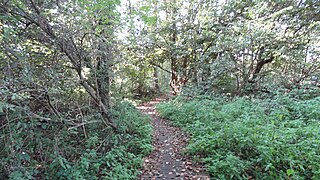
Ruislip Woods is a Site of Special Scientific Interest and national nature reserve covering 726 acres (294 ha) in Ruislip in the London Borough of Hillingdon. The woods became London's first national nature reserve in May 1997. Ruislip Local Nature Reserve at TQ 090 899 is part of the national nature reserve.
Denham Lock Wood is a 6.3-hectare (16-acre) biological Site of Special Scientific Interest (SSSI) next to the Grand Union Canal, and near Denham in the London Borough of Hillingdon. It was notified in 1986 and is managed by the London Wildlife Trust on behalf of Hillingdon Council. It lies within the Colne Valley Regional Park.

Lake Farm Country Park is an expanse of green belt land approximately 60 acres in size fringed by trees and the Grand Union Canal, situated in the south of Hayes in the London Borough of Hillingdon. Its formal status as a country park dates back to September 2002.

Barra Hall Park is an 11.06-hectare (27.3-acre) formal park situated near the centre of Hayes in the ward of Wood End in the London Borough of Hillingdon. The park came into existence in December 1923.

The Norman Leddy Memorial Gardens in Hayes is one of Hillingdon Borough's designated gardens of excellence. In September 2010, the Gardens earned a gold award for Best London Small Park in the London in Bloom competition.
Cranford Countryside Park is a 144-acre public park in Cranford, in the London Borough of Hillingdon, England. Situated in close proximity to Heathrow Airport, it is bordered by the M4 Motorway to the north, the A312 trunk road to the east, and by the towns of Harlington and Cranford to the southwest and southeast respectively. Although Cranford is mostly within the London Borough of Hounslow, the park itself is in the London Borough of Hillingdon, as it straddles the southernmost point of this borough. Although the park is in an urban location, it is vehicle-accessible only by a small road before a motorway entrance slip, and as such it has been described as a 'hidden gem'.


