Canton of Solothurn

Last updated

Canton of Solothurn
Kanton Solothurn (German)
Canton of Soleure
Flag of Canton of Solothurn.svg
Wappen Solothurn matt.svg
Canton of Solothurn
Location in Switzerland
Map of Solothurn

Karte Kanton Solothurn 2010.png
Coordinates: 47°9′N7°38′E / 47.150°N 7.633°E / 47.150; 7.633
Capital Solothurn
Largest city Olten
Subdivisions 122 municipalities, 10 districts
Government
   Executive Regierungsrat (5)
   Legislative Kantonsrat (100)
Area
[1]
  Total790.45 km2 (305.19 sq mi)
Population
 (December 2020) [2]
  Total277,462
  Density350/km2 (910/sq mi)
GDP
[3]
  Total CHF 18.209 billion (2020)
  Per capitaCHF 65,237 (2020)
ISO 3166 code CH-SO
Highest point 1,445 m (4,741 ft): Hasenmatt
Lowest point 277 m (909 ft): Birs at the cantonal border in Dornach
Joined 1481
Languages German
Website www.so.ch

The canton of Solothurn or canton of Soleure (German : Kanton Solothurn; Romansh : Chantun Soloturn; French : Canton de Soleure; Italian : Canton Soletta) is a canton of Switzerland. It is located in the northwest of Switzerland. The capital is Solothurn.

Contents

History

Figures 2 and 3 in the image are wearing traditional costumes of the Canton of Solothurn. Zentralbibliothek Solothurn - 1 COSTUME DU CANTON DE ZUG 2 ET 3 id DE SOLEURE 4 id DAPPENZELL - a0114.tif
Figures 2 and 3 in the image are wearing traditional costumes of the Canton of Solothurn.

The foundation of the village of Salodurum took place in the time of the Roman emperor Tiberius. The territory of the canton comprises land acquired by the former town, mainly in the Middle Ages. For that reason the shape of the canton is irregular and includes two exclaves along the French border, separated from the rest of the canton by Basel-Land, which form separate districts of the canton. In 1481, the canton became a member of the military alliance of the former Swiss confederation. At the end of the Reformation, Solothurn maintained its Catholic religion. Between 1798 and 1803 the canton was part of the Helvetic Republic. In 1803 Solothurn was one of the 19 Swiss cantons that were reconstituted by Napoleon ( Mediation ). In 1830, the population rebelled against the aristocratic regime and the canton became definitely liberal-democratic. Even though the population was strictly Roman Catholic, Solothurn did not join the Catholic separatist movement ( Sonderbund ) in 1845–7. Similarly, the federal constitutions of 1848 and 1874 were approved. The current constitution of the canton dates from 1987.

Geography

The canton is located in the north-west of Switzerland. To the west and south lie the cantons of Jura and Bern, to the east is Aargau. To the north the canton is bounded by the canton of Basel-Landschaft. Parts of two of the districts are exclaves and are located along the border of France (Grand Est). The lands are drained by the Aare river and its tributaries. The landscape is mostly flat, but it includes the foothills of the Jura massif. Part of this, the massif of the Weissenstein, overlooks Solothurn and the Mittelland from the north and has views of the Bernese Alps. The flat lands are a plain created by the Aare river. The total area of the canton is 791 km².

Political subdivisions

Districts

Districts of Canton Solothurn Districts of Canton Solothurn.png
Districts of Canton Solothurn

From 2005, Solothurn's ten districts are merged pairwise into five electoral districts, termed Amtei. From 2005, the districts have only a statistical significance.

Municipalities

There are 125 municipalities in the canton (As of 2009). [4]

Demographics

Biberist Biberist stapfacker hasenmatt.jpg
Biberist

The population is mostly German-speaking. In 2000 about 44% of the population was Roman Catholic, with most of the remainder being Protestant (31%). [5] The population of the canton (as of 31 December 2020) is 277,462. [2] As of 2007, the population included 46,898 foreigners, or about 18.7% of the total population. [6]

Historical population

The historical population is given in the following table:

Historic Population Data [7]
YearTotal PopulationSwissNon-SwissPopulation share
of total country
185069 67468 7419332.9%
188080 36278 1532 2092.8%
1900100 76296 5624 2003.0%
1950170 508164 1726 3363.6%
1970224 133189 82834 3053.6%
2000244 341201 87742 4643.4%
2020277,4623.2%

Economy

Up to the 19th century agriculture was the main economic activity in the canton. Agriculture is still of importance, but manufacturing and the service industry are now more significant. The industries of the canton are specialized in watches, jewellery, textiles, paper, cement and auto parts. Until recently the manufacturing of shoes was an important economic activity, but global competition thought that the Swiss canton was not competitive enough.

The canton is home to the Gösgen Nuclear Power Plant near Däniken which started operation in 1979.

Politics

Federal election results

Percentage of the total vote per party in the canton in the Federal Elections 1971-2015 [8]
PartyIdeology197119751979198319871991199519992003200720112015
FDP.The Liberals a Classical liberalism 34.338.739.037.236.332.825.425.424.021.018.421.2
CVP/PDC/PPD/PCD Christian democracy 27.726.027.626.725.122.221.521.421.020.417.914.8
SP/PS Social democracy 26.331.428.427.822.319.824.227.225.419.518.320.0
SVP/UDC Swiss nationalism * b *****6.718.622.527.124.328.8
Ring of Independents Social liberalism 7.2**4.03.52.91.6*****
EVP/PEV Christian democracy *****1.2**1.21.81.51.2
GLP/PVL Green liberalism **********5.03.5
BDP/PBD Conservatism **********4.43.4
PdA/PST-POP/PC/PSL Socialism **1.0*0.3*******
POCH Progressivism *3.44.13.5********
GPS/PES Green politics *****7.35.84.96.010.07.55.6
SD/DS National conservatism 4.6*****2.8**0.40.4*
EDU/UDF Christian right **********0.50.5
FPS/PSL Right-wing populism ****4.99.110.61.3****
Other*0.6*0.97.54.71.31.3**2.31.0
Voter participation %64.264.156.960.760.856.148.350.047.450.751.750.2
^a FDP before 2009, FDP.The Liberals after 2009
^b "*" indicates that the party was not on the ballot in this canton.

Transport

The canton has good connections with other parts of Switzerland, both by rail and by road. There is a railway junction at Olten with direct trains to Geneva, Zurich, Basel and the Ticino via Lucerne.

Notes and references

  1. Arealstatistik Land Cover - Kantone und Grossregionen nach 6 Hauptbereichen accessed 27 October 2017
  2. 1 2 "Ständige und nichtständige Wohnbevölkerung nach institutionellen Gliederungen, Geburtsort und Staatsangehörigkeit". bfs.admin.ch (in German). Swiss Federal Statistical Office - STAT-TAB. 31 December 2020. Retrieved 21 September 2021.
  3. Statistik, Bundesamt für (21 January 2021). "Bruttoinlandsprodukt (BIP) nach Grossregion und Kanton - 2008-2018 | Tabelle". Bundesamt für Statistik (in German). Retrieved 1 July 2023.
  4. "Liste officielle des communes de la Suisse - 01.01.2008". Office fédéral de la statistique. Archived from the original on 12 June 2009. Retrieved 15 December 2008.
  5. Federal Department of Statistics (2004). "Wohnbevölkerung nach Religion". Archived from the original (Interactive Map) on 24 September 2016. Retrieved 15 January 2009.
  6. Federal Department of Statistics (2008). "Ständige Wohnbevölkerung nach Staatsangehörigkeit, Geschlecht und Kantonen". Archived from the original (Microsoft Excel) on December 15, 2008. Retrieved November 5, 2008.
  7. "Solothurn (Kanton)". Historisches Lexikon der Schweiz (in German). Retrieved 25 January 2022.
  8. Nationalratswahlen: Stärke der Parteien nach Kantonen (Schweiz = 100%) (Report). Swiss Federal Statistical Office. 2015. Archived from the original on 2 August 2016. Retrieved 5 August 2016.


Related Research Articles

<span class="mw-page-title-main">Basel-Landschaft</span> Canton of Switzerland

Basel-Landschaft or Basel-Country, informally known as Baselland or Baselbiet, is one of the 26 cantons forming the Swiss Confederation. It is composed of five districts and its capital city is Liestal. It is traditionally considered a "half-canton", the other half being Basel-Stadt, its urban counterpart.

<span class="mw-page-title-main">Cantons of Switzerland</span> Member states of the Swiss Confederation

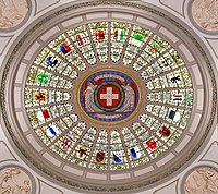
The 26 cantons of Switzerland are the member states of the Swiss Confederation. The nucleus of the Swiss Confederacy in the form of the first three confederate allies used to be referred to as the Waldstätte. Two important periods in the development of the Old Swiss Confederacy are summarized by the terms Acht Orte and Dreizehn Orte.

<span class="mw-page-title-main">Canton of Jura</span> Canton of Switzerland

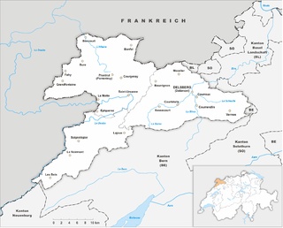
The Republic and Canton of Jura, less formally the Canton of Jura or Canton Jura, is the newest of the 26 Swiss cantons, located in the northwestern part of Switzerland. The capital is Delémont. It shares borders with the canton of Basel-Landschaft, the canton of Bern, the canton of Neuchatel, the canton of Solothurn, and the French régions of Bourgogne-Franche-Comté and Grand Est.

<span class="mw-page-title-main">Canton of Schaffhausen</span> Canton of Switzerland

The canton of Schaffhausen, also canton of Schaffhouse is the northernmost canton of Switzerland. The principal city and capital of the canton is Schaffhausen. The canton's territory is divided into three non-contiguous segments, where German territory reaches the Rhine. The large central part, which includes the capital, in turn separates the German exclave of Büsingen am Hochrhein from the rest of Germany.

<span class="mw-page-title-main">Canton of Fribourg</span> Canton of Switzerland

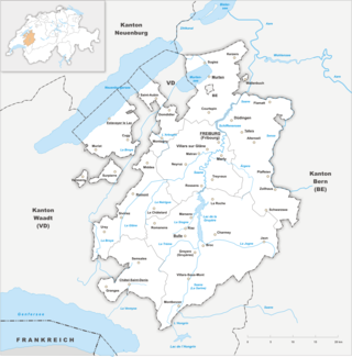
The canton of Fribourg, also canton of Freiburg is located in western Switzerland. The canton is bilingual, with French spoken by more than two thirds of the citizens and German by a little more than a quarter. Both are official languages in the canton. The canton takes its name from its capital city of Fribourg.

<span class="mw-page-title-main">Canton of Glarus</span> Canton of Switzerland

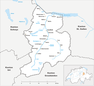
The canton of Glarus is a canton in east central Switzerland. The capital is Glarus. The population speaks a variety of Alemannic German. The majority of the population (81%) identifies as Christian, about evenly split between Protestants and Catholics.

<span class="mw-page-title-main">Appenzell Innerrhoden</span> Canton of Switzerland

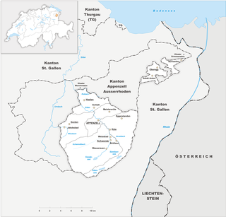
Appenzell Innerrhoden, in English sometimes Appenzell Inner-Rhodes, is one of the 26 cantons forming the Swiss Confederation. It is composed of six districts. The seat of the government and parliament is Appenzell. It is traditionally considered a "half-canton", the other half being Appenzell Ausserrhoden.

<span class="mw-page-title-main">Wangen an der Aare</span> Municipality in Bern, Switzerland

Wangen an der Aare is a municipality in the Oberaargau administrative district in the canton of Bern in Switzerland.

<span class="mw-page-title-main">Olten</span> Municipality in Solothurn, Switzerland

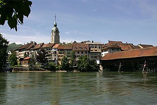
Olten is a town in the canton of Solothurn in Switzerland and capital of the district of the same name.

<span class="mw-page-title-main">Districts of Switzerland</span> Administrative division of Switzerland

Districts of Switzerland are a political subdivision for cantons. In the federally constituted Switzerland, each canton is completely free to decide its own internal organisation. Therefore, there exists a variety of structures and terminology for the subnational entities between canton and municipality, loosely termed districts. Most cantons are divided into Bezirke. They are also termed Ämter, Amtsbezirke, district or distretto. The Bezirke generally provide only administration and court organization. However, for historical reasons districts in cantons Graubünden and Schwyz are their own legal entities with jurisdiction over tax and often have their own Landsgemeinde.

<span class="mw-page-title-main">Grenchen</span> Municipality in Solothurn, Switzerland

Grenchen is a municipality in the district of Lebern in the canton of Solothurn in Switzerland.

<span class="mw-page-title-main">Murgenthal</span> Municipality in Aargau, Switzerland

Murgenthal is a municipality in the district of Zofingen in the canton of Aargau in Switzerland.

<span class="mw-page-title-main">Kleinlützel</span> Municipality in Solothurn, Switzerland

Kleinlützel is a municipality in the district of Thierstein in the canton of Solothurn in Switzerland. It is an exclave of the Canton of Solothurn, enclaved in the Canton of Basel-Country and Alsace.

<span class="mw-page-title-main">Flumenthal</span> Municipality in Solothurn, Switzerland

Flumenthal is a municipality in the district of Lebern in the canton of Solothurn in Switzerland.

<span class="mw-page-title-main">Olten District</span> District of the canton of Solothurn, Switzerland

Olten District is one of the ten districts of the canton of Solothurn in Switzerland, situated around the city of Olten. Together with the Gösgen District, it forms the electoral district of Olten-Gösgen. It has a population of 56,109.

<span class="mw-page-title-main">Gösgen District</span>

Gösgen District is one of the ten districts of the canton of Solothurn, Switzerland, situated to the northeast of the canton. Together with the Olten District, Gösgen forms the electoral district of Olten-Gösgen. It has a population of 24,793.

<span class="mw-page-title-main">Bucheggberg District</span> District in Switzerland

Bucheggberg District is one of the ten districts of the canton of Solothurn in Switzerland, situated to the southwest of the canton. Together with the Wasseramt District, it forms the Amtei of Wasseramt-Bucheggberg. It has a population of 8,009.

<span class="mw-page-title-main">Wasseramt District</span> District of Solothurn, Switzerland

Wasseramt District is one of the ten districts of the canton of Solothurn in Switzerland, situated to the south of the canton. Together with the Bucheggberg District, it forms the Amtei of Wasseramt-Bucheggberg. It has a population of 52,949.

Dorneck District is one of the ten districts of the canton of Solothurn in Switzerland, situated to the north of the canton. Together with Thierstein District, it forms the Amtei of Dorneck-Thierstein. It has a population of 20,802. Five of the district's eleven municipalities are exclaves, either within the canton of Basel-Country or bordering France.

Thierstein District is one of the ten districts of the canton of Solothurn in Switzerland, situated to the north of the canton. Together with the Dorneck District, it forms the Amtei of Dorneck-Thierstein. It has a population of 14,802.