List of extreme points of Switzerland

Last updated

This is a list of the extreme points of Switzerland .

Contents

Elevation

TypePointLocationCantonElevationCoordinates
highest point Monte Rosa Zermatt Valais 4634 m 45°56′12″N007°52′00″E / 45.93667°N 7.86667°E / 45.93667; 7.86667 (Dufourspitze - highest point (4634 m))
lowest point Lake Maggiore Locarno (district) Ticino 193 m 46°08′N8°48′E / 46.14°N 8.8°E / 46.14; 8.8 (Lake Maggiore surface - lowest point (195 m))
highest city St. Moritz St. Moritz Grisons 1822 m 46°29′50″N9°50′16″E / 46.49722°N 9.83778°E / 46.49722; 9.83778 (Davos - highest city)


highest village Juf Avers Grisons 2126 m 46°26′44″N009°34′45″E / 46.44556°N 9.57917°E / 46.44556; 9.57917 (Juf (Grisons) - highest village)
highest train station Jungfraujoch Fieschertal (in Bernese Oberland) Bern 3454 m 46°32′55″N007°58′59″E / 46.54861°N 7.98306°E / 46.54861; 7.98306 (Jungfraujoch Station - highest train station)
highest airport Samedan Airport Samedan Grisons 1707 m 46°32′02″N009°53′02″E / 46.53389°N 9.88389°E / 46.53389; 9.88389 (Samedan Airport - highest airport)
highest cable car Klein Matterhorn Zermatt Valais 3883 m 45°56′18″N007°43′47″E / 45.93833°N 7.72972°E / 45.93833; 7.72972 (Klein Matterhorn - highest cable car)
highest ski area Gobba di Rollin Zermatt Valais 3899 m
highest waterfall2nd of the Seerenbach Falls Betlis, Amden St. Gallen (302 m of 585 m) 47°09′N009°08′E / 47.150°N 9.133°E / 47.150; 9.133 (Seerenbach Falls - highest waterfalls)
(tallest structure) Grande Dixence Dam Hérémence Valais (285 m) 46°4.8′N7°24′E / 46.0800°N 7.400°E / 46.0800; 7.400 (Grande Dixence Dam - tallest structure)

Latitude and longitude

DescriptionLocation Municipality Canton Swiss Grid Coordinates Pic
Northernmost point 47°48'N at Oberbargen Bargen Schaffhausen 684600.234 / 295933.843 [1] 47°48′29.75″N008°34′04.43″E / 47.8082639°N 8.5678972°E / 47.8082639; 8.5678972 (Oberbargen - northernmost point) [2] [3]
Southernmost point 45°49'N at Pedrinate Chiasso Ticino 45°49′04.91″N009°00′59.34″E / 45.8180306°N 9.0164833°E / 45.8180306; 9.0164833 (Pedrinate - southernmost point) [2]
Westernmost point5°57'E Chancy Geneva 46°07′56.07″N005°57′22.69″E / 46.1322417°N 5.9563028°E / 46.1322417; 5.9563028 (Chancy - westernmost point) [2]
Easternmost point10°29'E at Piz Chavalatsch Müstair Grisons 833841 / 166938 [4] 46°36′46″N10°29′31″E / 46.61278°N 10.49194°E / 46.61278; 10.49194 (Piz Chavalatsch - easternmost point)

Related Research Articles

The extreme points of Norway include the coordinates that are farther north, south, east or west than any other location in Norway; and the highest and the lowest altitudes in the country. The northernmost point is Rossøya on Svalbard, the southernmost is Pysen in Mandal, the easternmost is Kræmerpynten on Svalbard, and the westernmost is Hoybergodden on Jan Mayen. The highest peak is Galdhøpiggen, standing at 2,469 m (8,100 ft) above mean sea level, while the lowest elevation is sea level at the coast.

The extreme points of the Faroe Islands include the coordinates that are further north, south, east or west than any other location in the Faroe Islands; and the highest and the lowest elevations in the territory.

<span class="mw-page-title-main">Extreme points of Moldova</span>

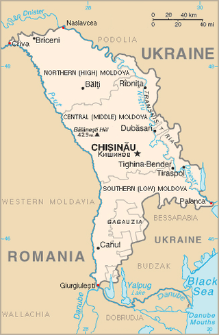
This is a list of the extreme points of Moldova: the points that are farther north, south, east or west than any other location, as well as the highest and lowest points in the country.

<span class="mw-page-title-main">National Register of Historic Places listings in Beaver County, Pennsylvania</span>

This is a list of the National Register of Historic Places listings in Beaver County, Pennsylvania.

The Sq'éwlets First Nation (Scowlitz) is the band government of Skaulits subgroup of the Stó:lō people located on Harrison Bay in the Upper Fraser Valley region between Chehalis (E) and Lake Errock, British Columbia, Canada (W). They are a member government of the Stó:lō Tribal Council.

The following lists include extreme and significant points of the geography of South Korea.

<span class="mw-page-title-main">Extreme points of Georgia (country)</span>

This is a list of the extreme points of Georgia: the points that are farther north, south, east or west than any other location, as well as the highest and lowest points in the country.

References

  1. GIS SH [ permanent dead link ]
  2. 1 2 3 - Bing(formerly) MSN Maps as per instructions at Wikipedia: Obtaining geographic coordinates
  3. "SwissFot: Photo". Archived from the original on 2011-07-07. Retrieved 2008-01-26.
  4. Uffizi d'agricultura e da geoinfurmaziun dal chantun Grischun [ permanent dead link ]

See also