List of glaciers in Switzerland

Last updated

This is a non-exhaustive list of the major glaciers in Switzerland. It contains their surface area, their lengths since the start of measurement and the most current year, their height and their outflow. Most of them are retreating and many will vanish. [1]

Contents

All of these glaciers are located within the Swiss Alps. Most of them are situated in the Pennine and Bernese Alps. The Jungfrau-Aletsch protected area includes the largest glaciers of the Alps.

There are glaciers in the four major drainage basins of Switzerland. The Rhine and Rhône basins are located on the northern side of the Alps while the Po basin is located on the south side of the Alps. The Danube basin is located on the east side of the Alps. There are no glaciers in the Swiss portion of the Adige basin.

There are approximately 1,800 glaciers in the Swiss Alps. [2]

List

Name Canton Range Area
1973 (km²) [3]
Start of
measurement
(year) [3]
Max length
(km) [3]
1973
length
(km) [3]
2016
length
(km) [3]
length change
(m) [3]
Highest point in drainage basin [4] Altitude
(m)
Front alt.
(m)
OutflowBasin
Grand Aletsch VS Bernese Alps 86.63187025.623.9522.47-3132 Aletschhorn 4,1931,600 Massa Rhône
Gorner VS Pennine Alps 59.37188214.9913.5012.32-2672 Dufourspitze (Monte Rosa)4,6342,140Gornera Rhône
Fiesch VS Bernese Alps 34.21189115.9215.3514.51-1405 Finsteraarhorn 4,2731,700Wysswasser Rhône
Unteraar BE Bernese Alps 29.48187614.4112.9511.85-2561 Finsteraarhorn 4,2741,960 Aare Rhine
Lower Grindelwald BE Bernese Alps 20.8418799.468.305.95-3504 Mönch 4,1071,300Weisse Lütschine Rhine
Upper Aletsch VS Bernese Alps 22.81187010.289.058.82-1461 Aletschhorn 41932,140 Massa Rhône
Corbassière VS Pennine Alps 18.31188910.6410.159.47-1168 Grand Combin 4,3142,200Dyure de Corbassière Rhône
Rhone VS Urner Alps 17.6018799.098.007.65-1439 Dammastock 3,6302,200 Rhône Rhône
Otemma VS Pennine Alps 17.5118819.518.707.22-2291 Pigne d'Arolla 3,7902,450Dranse de Bagnes Rhône
Findel VS Pennine Alps 17.3618859.247.806.63-2618 Rimpfischhorn 4,1992,500Findelbach Rhône
Gauli BE Bernese Alps 17.7019586.716.555.4-1306 Bärglistock 3,6562,150Gaulisee/Ürbachwasser Rhine
Morteratsch GR Bernina Range 16.4018788.637.005.85-2784 Piz Bernina 40492,040Ova da Morteratsch Danube
Trift BE Urner Alps 16.5518617.65.753.66-3938West of Eggstock 3,4851,660 Triftwasser Rhine
Zmutt VS Pennine Alps 16.8918927.496.706.3-1182 Matterhorn 4,4782,240Zmuttbach Rhône
Zinal VS Pennine Alps 15.4218918.67.506.9-1700 Dent Blanche 4,3572,060Navisence Rhône
Hüfi Uri Glarus Alps 13.6418828.047.106.74-1300 Schärhorn 3,2951,800Chärstelenbach Rhine
Arolla VS Pennine Alps 13.1718566.234.804.34-1893 Pigne d'Arolla 3,7902,160Borgne d'Arolla Rhône
Mont Miné VS Pennine Alps 10.9719568.488.357.71-769 Bouquetins 3,8381,980Borgne de Ferpècle Rhône
Long VS Bernese Alps 10.0918887.236.906.45-780 Mittaghorn 3,8922,080Lonza Rhône
Brenay VS Pennine Alps 9.9618816.325.954.92-1399 La Ruinette 3,8752,580Dyure du Brenay Rhône
Allalin VS Pennine Alps 9.8718817.076.505.91-1159 Rimpfischhorn 4,1992,600Saaser Vispa Rhône
Ferpècle VS Pennine Alps 9.7718917.696.606.23-1463 Dent Blanche 4,3572,160Borgne de Ferpècle Rhône
Upper Grindelwald BE Bernese Alps 9.5218796.966.654.02-2938North of Schreckhorn 3,7501,380Schwarze Lütschine Rhine
Rätzli / Plaine Morte BE(/VS) Bernese Alps 9.0919255.925.204.87-1048 Wildstrubel 3,2442,470Trüebbach, La Tièche Rhine, Rhône
Forno GR Bregaglia Alps 8.7218577.66.155.28-2324 Cima di Castello 3,3792,220Orlegna Po
Saleina VS Mont Blanc massif 8.5718787.046.455.95-1087 Aiguille d'Argentière 3,9011,760Reuse de Saleina Rhône
Roseg GR Bernina Range 8.5218556.714.902.42-4288 Piz Roseg 3,9372,160Ova da Roseg Danube
Fee Glacier VS Pennine Alps 7.4618835.895.004.57-1318 Dom 4,5452,100Feevispa Rhône
Palü GR Bernina Range 6.4718944.883.803.51-1366 Piz Palü 3,9012,580Acqua da Palü Po
Trient VS Mont Blanc massif 6.4018795.294.903.96-1328 Aiguille du Tour 3,5401,880Trient Rhône
Moming VS Pennine Alps 6.3918794.193.603.06-1134 Weisshorn 4,5062,500Navisence Rhône
Gries VS Lepontine Alps 6.2318477.845.704.88-2959 Blinnenhorn 3,3742,420Ägene Rhône
Tschierva GR Bernina Range 6.2019345.564.753.89-1665 Piz Bernina 4,0492,260Ova da Roseg Danube
Tschingel BE Bernese Alps 6.1918933.873.653.52-343 Tschingelhorn 3,5622,160Tschingel-Litschina Rhine
Rosenlaui BE Bernese Alps 6.1418805.35.155.15-151 Mittelhorn 3,7042,000Rosenlauibach Rhine
Damma UR Urner Alps 5.0919212.852.351.32-1525 Dammastock 3,6302,060Dammareuss Rhine
Wildstrubel VS Bernese Alps 4.8119172.832.652.29-535 Wildstrubel 3,2442,560Lämmerendalu Rhine
Tsanfleuron VS/Vaud Bernese Alps 3.8118844.913.703-1907 Oldenhorn 3,1232,460Le Lachon Rhône
Albigna GR Bregaglia Alps 3.5319064.883.703.49-1386 Cima di Castello 3,3792,200Albigna Po
Silvretta GR Silvretta Alps 3.3519563.423.303.03-390 Silvrettahorn 3,2442,480Verstanclabach Rhine
Biferten GL Glarus Alps 2.8118834.554.404.19-360 Tödi 3,6141,960Bifertenbach Rhine
Basòdino TI Lepontine Alps 2.3118992.021.501.28-733 Basòdino 3,2722,500Bavona Po
Vadret Tiatscha (La Cudera) GR Silvretta Alps 2.0718503.442.051.64-1792East of Verstanclahorn 3,2202,680Lavinuoz Danube

See also

Related Research Articles

<span class="mw-page-title-main">Geography of Switzerland</span>

The geography of Switzerland features a mountainous and landlocked country located in Western and Central Europe. Switzerland's natural landscape is marked by its numerous lakes and mountains. It is surrounded by five countries: Austria and Liechtenstein to the east, France to the west, Italy to the south and Germany to the north. Switzerland has a maximum north–south length of 220 kilometres (140 mi) and an east–west length of about 350 kilometres (220 mi).

<span class="mw-page-title-main">Swiss Alps</span> Portion of the Alps that lies within Switzerland

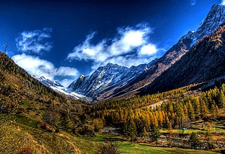
The Alpine region of Switzerland, conventionally referred to as the Swiss Alps, represents a major natural feature of the country and is, along with the Swiss Plateau and the Swiss portion of the Jura Mountains, one of its three main physiographic regions. The Swiss Alps extend over both the Western Alps and the Eastern Alps, encompassing an area sometimes called Central Alps. While the northern ranges from the Bernese Alps to the Appenzell Alps are entirely in Switzerland, the southern ranges from the Mont Blanc massif to the Bernina massif are shared with other countries such as France, Italy, Austria and Liechtenstein.

<span class="mw-page-title-main">Bernese Alps</span> Part of the Alps mountain range in Switzerland

The Bernese Alps are a mountain range of the Alps, located in western Switzerland. Although the name suggests that they are located in the Berner Oberland region of the canton of Bern, portions of the Bernese Alps are in the adjacent cantons of Valais, Fribourg and Vaud, the latter being usually named Fribourg Alps and Vaud Alps respectively. The highest mountain in the range, the Finsteraarhorn, is also the highest point in the canton of Bern.

<span class="mw-page-title-main">Valais</span> Canton of Switzerland

Valais, more formally, the Canton of Valais, is one of the 26 cantons forming the Swiss Confederation. It is composed of thirteen districts and its capital and largest city is Sion.

<span class="mw-page-title-main">Jungfrau</span> Mountain summit in the Bernese Alps, between the Swiss cantons of Bern and Valais

The Jungfrau, at 4,158 meters (13,642 ft) is one of the main summits of the Bernese Alps, located between the northern canton of Bern and the southern canton of Valais, halfway between Interlaken and Fiesch. Together with the Eiger and Mönch, the Jungfrau forms a massive wall of mountains overlooking the Bernese Oberland and the Swiss Plateau, one of the most distinctive sights of the Swiss Alps.

<span class="mw-page-title-main">Aletsch Glacier</span> Largest glacier in the Alps

The Aletsch Glacier or Great Aletsch Glacier is the largest glacier in the Alps. It has a length of about 23 km (14 mi) (2014), a volume of 15.4 km3 (3.7 cu mi) (2011), and covers about 81.7 km2 (2011) in the eastern Bernese Alps in the Swiss canton of Valais. The Aletsch Glacier is composed of four smaller glaciers converging at Konkordiaplatz, where its thickness was measured by the ETH to be still near 1 km (3,300 ft). It then continues towards the Rhône valley before giving birth to the Massa. The Aletsch Glacier is – like most glaciers in the world today – a retreating glacier. As of 2016, since 1980 it lost 1.3 kilometres (0.81 mi) of its length, since 1870 3.2 kilometres (2.0 mi), and lost also more than 300 metres (980 ft) of its thickness.

<span class="mw-page-title-main">Jungfraujoch</span> Glacier saddle in the Swiss Alps

The Jungfraujoch is a saddle connecting two major 4000ers of the Bernese Alps: the Jungfrau and the Mönch. It lies at an elevation of 3,463 metres (11,362 ft) above sea level and is directly overlooked by the rocky prominence of the Sphinx. The Jungfraujoch is a glacier saddle, on the upper snows of the Aletsch Glacier, and part of the Jungfrau-Aletsch area, situated on the boundary between the cantons of Bern and Valais, halfway between Interlaken and Fiesch.

<span class="mw-page-title-main">Lötschental</span> Valley in Switzerland

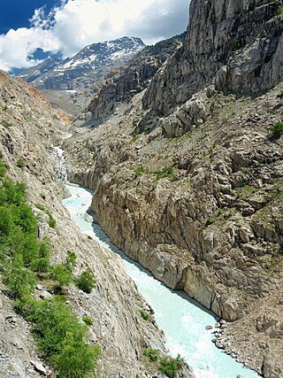
The Lötschental is the largest valley on the northern side of the Rhône valley in the canton of Valais in Switzerland. It lies in the Bernese Alps, with the Lonza running down the length of the valley from its source within the Langgletscher.

<span class="mw-page-title-main">Rhône Glacier</span>

The Rhône Glacier is a glacier in the Swiss Alps and the source of the river Rhône and one of the primary contributors to Lake Geneva in the far eastern end of the Swiss canton of Valais. Because the glacier is located close to the Furka Pass road it is easily accessible.

<span class="mw-page-title-main">Monte Rosa</span> Massif in Switzerland and Italy

Monte Rosa is a mountain massif in the eastern part of the Pennine Alps, on the border between Italy and Switzerland (Valais). The highest peak of the massif, amongst several peaks of over 4.000 m, is the Dufourspitze, the second highest mountain in the Alps and western Europe, after Mont Blanc. The east face of the Monte Rosa towards Italy has a height of about 2.400 meters and is the highest mountain wall of the Alps.

<span class="mw-page-title-main">Swiss Plateau</span> Plateau in the European Alps

The Swiss Plateau or Central Plateau is one of the three major landscapes in Switzerland, lying between the Jura Mountains and the Swiss Alps. It covers about 30% of the Swiss surface area, and is partly flat but mostly hilly. The average height is between 400 metres (1,300 ft) and 700 metres (2,300 ft) AMSL. It is by far the most densely populated region of Switzerland, the center of economy and important transportation.

<span class="mw-page-title-main">Gorner Glacier</span> Glacier on the Monte Rosa massif

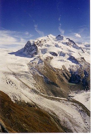
The Gorner Glacier is a valley glacier found on the west side of the Monte Rosa massif close to Zermatt in the canton of Valais, Switzerland. It is about 12.4 km (7.7 mi) long (2014) and 1 to 1.5 km wide. The entire glacial area of the glacier related to Gorner Glacier is 53 km2 (20 sq mi) (2007), which makes it the second largest glacial system in the Alps after the Aletsch Glacier system; however, in length it ranks third behind the Aletsch and Fiescher Glaciers. Numerous smaller glaciers connect with the Gorner Glacier. Its (former) tributaries are the Gorner Glacier, Monte Rosa Glacier, Grenzgletscher, Zwillingsgletscher, Schwärzegletscher, Breithorngletscher, Triftjigletscher, and Unterer Theodulgletscher.

<span class="mw-page-title-main">Morteratsch Glacier</span> Glacier in Switzerland

The Morteratsch Glacier is the largest glacier by area in the Bernina Range of the Bündner Alps in Switzerland.

<span class="mw-page-title-main">Tourism in Switzerland</span> Overview of tourism in Switzerland

Tourists are drawn to Switzerland's diverse landscape as well as the available activities, which take advantage of the Alpine climate and landscapes, in particular skiing and mountaineering.

<span class="mw-page-title-main">Findel Glacier</span> Glacier in Switzerland

The Findel Glacier is a valley glacier in the Monte Rosa massif east of Zermatt in the Pennine Alps. It has a length of 8 km (5.0 mi) and covers an area of 19 km2 (7.3 sq mi).

<span class="mw-page-title-main">Oberaletsch Glacier</span>

The Oberaletsch Glacier is a valley glacier on the south side of the Bernese Alps, in the canton of Valais. It had a length of 9 km (5.6 mi) with an average width of just under 1 km (0.62 mi) and an area of about 22 km2 (8.5 sq mi) in 1973.

<span class="mw-page-title-main">Eggishorn</span> Mountain in Switzerland

The Eggishorn is a mountain in the southeastern part of the Bernese Alps, located north of Fiesch in the Swiss canton of Valais. A cable car station is located on a secondary summit named Fiescherhorli, 500 metres south of the main peak.

<span class="mw-page-title-main">Jungfrau-Aletsch protected area</span> Protected area in south-western Switzerland

The Jungfrau-Aletsch protected area is located in south-western Switzerland between the cantons of Bern and Valais. It is a mountainous region in the easternmost side of the Bernese Alps, containing the northern wall of Jungfrau and Eiger, and the largest glaciated area in western Eurasia, comprising the Aletsch Glacier. The Jungfrau-Aletsch protected area is the first World Natural Heritage site in the Alps; it was inscribed in 2001.

<span class="mw-page-title-main">Hydrology of Switzerland</span>

Hydrology is the science which studies the water cycle as a whole, hence the water exchanges between soil and atmosphere but also between the soil and sub ground (groundwater).

<span class="mw-page-title-main">Massa (river)</span> River in Switzerland

The Massa is a seven kilometre long river in the eastern Bernese Alps in the Swiss canton of Valais. It is mainly fed by the melt-water from the Aletsch Glacier. It passes through the Massa Gorge and flows into the Stausee Gibidum reservoir and onwards to its confluence with the Rhône.

References

  1. Jonathan Amos (19 December 2008). "Swiss Glaciers 'in full retreat'". BBC News. San Francisco.
  2. "Glaciers set to disappear from the Alps". SWI swissinfo.ch, a branch of the Swiss Broadcasting Corporation. December 8, 2006. Retrieved 2019-10-26.
  3. 1 2 3 4 5 6 "Welcome to the Glacier Monitoring in Switzerland (GLAMOS)" (research site). Zürich, Fribourg, Bern: ETH Zurich, University of Fribourg, University of Zurich . Retrieved 2018-01-16.
  4. "Topographical catchment areas of Swiss waterbodies". Wabern, BE, Switzerland: Federal Office for the Environment (FOEN) via map.geo.admin.ch swisstopo.