Painter is a town in Accomack County, Virginia, United States. The population was recorded at 229 at the 2010 census.

Urbanna is a town in Middlesex County, Virginia, United States. Urbanna means “City of Anne” and was named in honor of England's Queen Anne. The population was 476 at the 2010 census.

Santa Fe de Antioquia is a municipality in the Antioquia Department, Colombia. The city is located approximately 58 kilometres (36 mi) north of Medellín, the department capital. It has a population of approximately 23,000 inhabitants.
Argelia is a town and municipality in Antioquia Department, Colombia. Part of the subregion of Eastern Antioquia.

Belmira is a town and municipality in the northern subregion of the Colombian department of Antioquia. Approximately 62 km from the city of Medellin.
Betania is a town and municipality in the Colombian department of Antioquia. Part of the subregion of Southwestern Antioquia. It exists 33 mi/53 km SW of Medellín. Main industries include coffee, sugarcane, cacao, and livestock.

Cocorná is a town and municipality in the Colombian department of Antioquia. Part of the subregion of Eastern Antioquia.

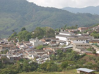
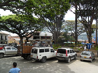
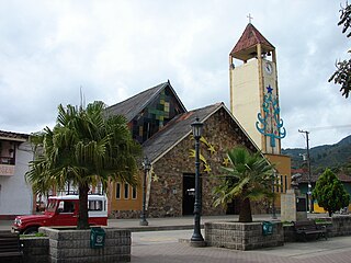
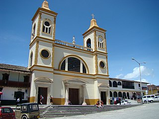
Concepción is a town and municipality in the Colombian department of Antioquia. Part of the subregion of Eastern Antioquia.
Gómez Plata is a town and municipality in the Colombian department of Antioquia. Part of the subregion of Northern Antioquia.

Granada is a town and municipality in the Colombian department of Antioquia. It is part of the subregion of Eastern Antioquia. For More Info Amigranada

Heliconia is a town and municipality in Antioquia Department, Colombia.
La Unión is a town and municipality in the Colombian department of Antioquia. It is part of the subregion of Eastern Antioquia.

Sonsón is a municipality in the Colombian department of Antioquia. Sonsón is located in Eastern Antioquia. It is one of the seats of the Roman Catholic Diocese of Sonsón–Rionegro. Sonsón celebrates "Las Fiestas Del Maíz"- during the month of August, being the most traditional, historical and representative festival in western Colombia.

San Roque is a town and municipality in the Colombian department of Antioquia. It is part of the subregion of Northeastern Antioquia. The municipality was founded by Francisco Martinez de Ospina on the 8 February 1880. The town is located between the Nare River and the Nus River. The town was created due to the presence of gold in the areas around the town. The town is located 121 km north of Medellín. The people of this town celebrate most of the traditional festivals that are celebrated in Colombia.

Sopetrán is a municipality of Colombia, located in the subregion west of the state of Antioquia. It is bounded to the north by the municipality of Olaya, to the east by the municipality of Belmira, to the south by the municipalities of San Jerónimo and Ebéjico, and to the west by the municipality of Santa Fe de Antioquia. It is 59 kilometers from the city of Medellin, the state capital of Antioquia. The municipality of Sopetrán has an area of 223 square kilometers.

Yarumal is a municipality in the Antioquia Department, Colombia.

Briceño is a town and municipality in Antioquia Department, Colombia. Part of the subregion of Northern Antioquia.

Aguadas is a town and municipality in the Colombian Department of Caldas. It is bounded on the north by Abejorral, on the east by Sonsón, Salamina in the southeast, on the south by Pacora, on the west with Caramanta and Valparaiso, and the northwest with La Pintada. The municipality of Aguadas was founded in 1808 by José Narciso Estrada. It is located in the northern part of the department. In addition to the fame of Aguadeño Hats, which are very similar to the Panama Hat made of palm straw called iraca in Colombia. Aguadas offers visitors its historic center, declared a National Monument in 1982. It has a temperate climate thanks to the variety of climates ranging from warm to moor.

Puerto Guzmán is a town and municipality located in the Putumayo Department, Republic of Colombia.
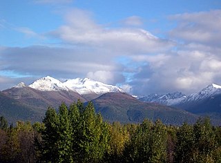
Anchorage, Alaska has a subarctic climate with the code Dfc according to the Köppen climate classification due to its short, cool summers. Average daytime summer temperatures range from approximately 55 to 78 °F ; average daytime winter temperatures are about 5 to 30 °F. Anchorage has a frost-free growing season that averages slightly over one hundred days.