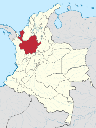
Antioquia is one of the 32 departments of Colombia, located in the central Northwestern part of Colombia with a narrow section that borders the Caribbean Sea. Most of its territory is mountainous with some valleys, much of which is part of the Andes mountain range. Antioquia has been part of many territorial divisions of former countries created within the present-day territory of Colombia. Prior to adoption of the Colombian Constitution of 1886, Antioquia State had its own sovereign government.

Chocó Department is a department of the Pacifc region of Colombia known for the largest Afro-Colombian population in the nation. It is in the West of the country, and is the only Colombian department to have coastlines on both the Pacific Ocean and the Atlantic Ocean. It contains all of Colombia's border with Panama. Its capital is Quibdó.

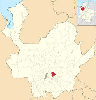
Abejorral is a town and municipality in Antioquia Department, Colombia. Part of the subregion of Eastern Antioquia. It borders to the north with the municipalities of Montebello, La Ceja and La Unión, to the east with municipality of Sonsón, to the south with the department of Caldas and to the west with the municipalities of Santa Bárbara y Montebello. The population was 17,599 at the 2018 census.

Alejandría is a town and municipality in the Antioquia Department, Colombia. It is part of the sub-region of Eastern Antioquia and is bordered to the north by the municipalities of Concepción, Santo Domingo and San Roque, on the east by the municipality of San Rafael, on the south by the municipalities of San Rafael and Guatapé, and on the west by the municipalities of El Penol and Concepción. Its capital is 90 kilometers from the city of Medellin, the capital of Antioquia department. The municipality has an area of 149 km2.

Arboletes is a town and municipality in the subregion of Urabá in Antioquia Department, Colombia.

Caucasia is a municipality located in the subregion of Bajo Cauca Antioquia department, in Colombia. Bounded on the south by the department of Córdoba, in the east by the municipalities of Antioquia in Nechí and El Bagre, on the north by the municipality of Zaragoza, and west to the town of Cáceres, and is located 270 km from Medellín.

El Bagre is a town and municipality in the Colombian department of Antioquia. It lies at an altitude of 57 m above sea level.

Guatapé is a town and municipality in the Department of Antioquia, Colombia. It is a part of the subregion of Eastern Antioquia and is located 79 kilometres (49 mi) from Medellín, the capital of the department. Guatapé is bordered on the north by Alejandría, San Rafael to the east, and Granada and El Peñol to the south. This town is the gathering place for Las Vegas, referring to the small farms of the area.

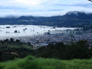
Jardín, is a town and municipality in the southwest region of Antioquia, Colombia. It is bounded by the Andes, Jericó, and Támesis municipalities to the north and the Caldas department to the south. The municipality is located between the San Juan River and a branch of the Western Cordillera. Jardín is identified by its preserved colonial architecture, lush vegetation, and abundant rivers and streams.
San Vicente Ferrer is a town and municipality in Antioquia Department, Colombia. The population was 18,051 at the 2018 census. The town of San Vicente is part of the sub-region of Eastern Antioquia.

Yolombó is a town and municipality in the Colombian department of Antioquia. It is part of the subregion of Northeastern Antioquia, located 108 km from Medellín.

Puerto Berrío is a municipality and town in the Colombian department of Antioquia. It is part of the Magdalena Medio Antioquia sub-region.

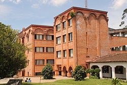
Rionegro is a city and municipality in Antioquia Department, Colombia, located in the subregion of Eastern Antioquia. The official name of the city is "Ciudad Santiago de Arma de Rionegro". Rio Negro means "Black River" in Spanish, as the city received its name after a river that looks black because of the shadows cast by trees. The river traverses the city and it is the most prominent geographical feature of the municipality. Rionegro is also sometimes called the Cuna de la democracia as it was one of the most important cities during the era of the Colombia's struggle for independence and the 1863 constitution was written in the city.

San Luis is a municipality in Colombia, located in the department of Antioquia. It is limited in the north by the municipalities of San Carlos and Puerto Nare, in the east by the municipality of Puerto Triunfo, in the south by the municipality of San Francisco and in the west by the municipalities of Cocorná and Granada.
Riosucio is a municipality and town in the Department of Chocó, Colombia. The municipality and town are located in the Atrato River basin, on the Chocoan side of Urabá, a region spanning the departments Chocó and Antioquia.

Eastern Antioquia is subregion of the Colombian Department of Antioquia. The region consists of 23 municipalities.

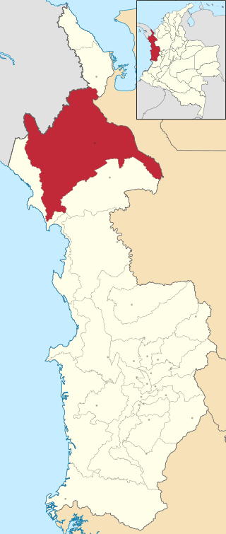
Urabá Antioquia is a subregion in the Colombian Department of Antioquia that consists of two enclaves, one forming the northwest corner of the department the other, the west, both are along the Atrato River and are separated by the El Carmen del Darién and Riosucio municipalities of the Chocó Department with territories in both municipalities in dispute with Chocó. The region is made up by 11 municipalities. Most of this region's northern portion is part of the Colombian Caribbean Region bordering the Caribbean sea.
La Ceja del Tambo, known as La Ceja, is a town and municipality in the Antioquia Department of Colombia. It is part of the subregion of Eastern Antioquia. La Ceja borders the Rionegro and Carmen de Viboral municipalities to the north, La Unión to the east, and Montebello and Retiro to the west. It is located approximately 41 kilometers from Medellín, the department capital.
La Linda is a settlement in El Carmen de Viboral Municipality, Antioquia Department in Colombia.