Antioquia is one of the 32 departments of Colombia, located in the central northwestern part of Colombia with a narrow section that borders the Caribbean Sea. Most of its territory is mountainous with some valleys, much of which is part of the Andes mountain range. Antioquia has been part of many territorial divisions of former countries created within the present-day territory of Colombia. Prior to adoption of the Colombian Constitution of 1886, Antioquia State had its own sovereign government.

Angostura is a town and municipality in Antioquia Department, Colombia. It is part of the subregion of Northern Antioquia. The population was 10,500 at the 2018 census.

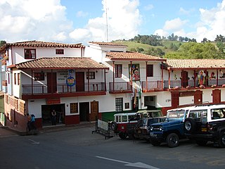
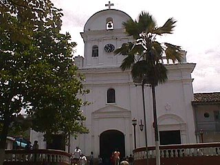
Santa Fe de Antioquia is a municipality in the Antioquia Department, Colombia. The city is located approximately 58 kilometres (36 mi) north of Medellín, the department capital. The population was 23,216 at the 2018 census.

Caucasia is a municipality located in the subregion of Bajo Cauca Antioquia department, in Colombia. Bounded on the south by the department of Córdoba, in the east by the municipalities of Antioquia in Nechí and El Bagre, on the north by the municipality of Zaragoza, and west to the town of Cáceres, and is located 270 km from Medellín.

Ebéjico is a town and municipality in the West of Antioquia Department, Colombia. The population was 10,338 at the 2018 census.
Entrerrios is a municipality in the Colombian subregion of Northern Antioquia, in the department of Antioquia. The population was 8,820 at the 2018 census. The population, according to the 2002 census, was 8,305 inhabitants.

Jardín, is a town and municipality in the southwest region of Antioquia, Colombia. It is bounded by the Andes, Jericó, and Támesis municipalities to the north and the Caldas department to the south. The municipality is located between the San Juan River and a branch of the Western Cordillera. Jardín is identified by its preserved colonial architecture, lush vegetation, and abundant rivers and streams.

Jericó is a town, municipality and Catholic bishopric in the Colombian department of Antioquia. It is part of the subregion of Southwestern Antioquia. The distance reference from Medellín city, the capital of the department, is 104 km. It lies 1,910 m above sea level.

San Roque is a town and municipality in the Colombian department of Antioquia. Part of the subregion of Northeastern Antioquia, it is located 1,475 m above sea level. The municipality was founded by Francisco Martinez de Ospina on the 8 February 1880. The town is located between the Nare River and the Nus River. The town was created due to the presence of gold in the areas around the town. The town is located 121 km north of Medellín. The people of this town celebrate most of the traditional festivals that are celebrated in Colombia.

Sopetrán is a municipality of Colombia, located in the subregion west of the state of Antioquia. It is bounded to the north by the municipality of Olaya, to the east by the municipality of Belmira, to the south by the municipalities of San Jerónimo and Ebéjico, and to the west by the municipality of Santa Fe de Antioquia. The population was 13,748 at the 2018 census. It is 59 kilometers from the city of Medellin, the state capital of Antioquia. The municipality of Sopetrán has an area of 223 square kilometers.

Titiribí is a town and municipality in the Colombian department of Antioquia. Located at an elevation of 1,550 m above sea level, it is part of the sub-region of Southwestern Antioquia.

Puerto Berrío is a municipality and town in the Colombian department of Antioquia. It is part of the Magdalena Medio Antioquia sub-region.

Salgar is a town and municipality in the Colombian department of Antioquia.

Rionegro is a city and municipality in Antioquia Department, Colombia, located in the subregion of Eastern Antioquia. The official name of the city is Ciudad Santiago de Arma de Rionegro. Rio Negro means "Black River" in Spanish, as the city received its name after a river that looks black because of the shadows cast by trees. The river traverses the city and it is the most prominent geographical feature of the municipality. Rionegro is also sometimes called the Cuna de la democracia as it was one of the most important cities during the era of the Colombia's struggle for independence and the 1863 constitution was written in the city.

San Rafael is a town and municipality in Antioquia Department, Colombia. Part of the subregion of Eastern Antioquia.
San Jerónimo is a municipality in Colombia, located in the Western subregion of the Department of Antioquia. Its main town is 35 kilometers from the city of Medellín, the capital of the department of Antioquia. The municipality has an area of 155 square kilometers.

San Luis is a municipality in Colombia, located in the department of Antioquia. It is limited in the north by the municipalities of San Carlos and Puerto Nare, in the east by the municipality of Puerto Triunfo, in the south by the municipality of San Francisco and in the west by the municipalities of Cocorná and Granada.

Eastern Antioquia is subregion of the Colombian Department of Antioquia. The region consists of 23 municipalities.
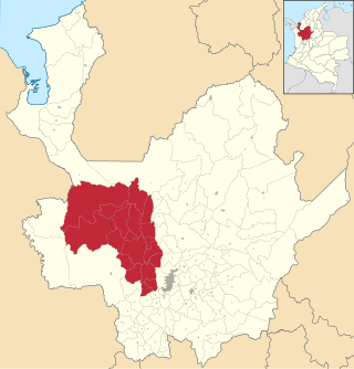
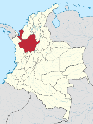
Western Antioquia is a subregion in the Colombian Department of Antioquia. The region is made up by 18 municipalities.

The Metropolitan Area of the Aburrá Valley is the second most important and populated metropolitan area in Colombia. The region is made up of ten municipalities, Medellín being the most important, largest and the capital city of the Antioquia Department.