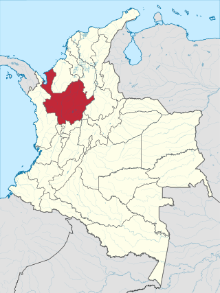
Antioquia is one of the 32 departments of Colombia, located in the central northwestern part of Colombia with a narrow section that borders the Caribbean Sea. Most of its territory is mountainous with some valleys, much of which is part of the Andes mountain range. Antioquia has been part of many territorial divisions of former countries created within the present-day territory of Colombia. Prior to adoption of the Colombian Constitution of 1886, Antioquia State had its own sovereign government.

Quindío is a department of Colombia. It's located in the western central of the country, specifically in the Andean region. Its capital is Armenia. It's famous for the quality of the coffee plantations, colorful architecture, benign weather, variety of hotel accommodations and tourist landmarks. This department is located in a strategic area, in the center of the triangle formed by the three main cities of the country: Bogotá, Medellín and Cali. Quindío is the second-smallest Colombian department with 12 municipalities. Ethnographically and culturally, it belongs to the Paisa region.

Puerto Boyacá is a Colombian river-port town and municipality by the Magdalena River in the Boyacá Department, where is also considered a Special Trade Zone due to its port status. Its main industries are oil exploration and processing. In the 1980s and early 1990s, Puerto Boyacá was affected intensively by the Colombian Armed Conflict.

Amalfi is a town and municipality of the Colombian Andes, northern part of the Central Mountain Range in the Antioquia Department and part of the subregion of Northeastern Antioquia. The territory of Amalfi is bordered by the municipalities of Anorí and Segovia at its north; Segovia, Remedios and Vegachí at the east; Vegachí, Yalí, Yolombó and Gómez Plata at the south and Anorí and Guadalupe at the west. The town is served by Amalfi Airport.

Santa Fe de Antioquia is a municipality in the Antioquia Department, Colombia. The city is located approximately 58 kilometres (36 mi) north of Medellín, the department capital. The population was 23,216 at the 2018 census.

Bello is a city and municipality in Antioquia Department, Colombia and a suburb of Medellín, the department capital. Bello is part of the Metropolitan Area of the Aburrá Valley in the department of Antioquia. It is bordered on the north by the municipality of San Pedro de los Milagros, on the east by the municipality of Copacabana, on the south by the municipality of Medellín and on the west by the municipalities of Medellín and San Jerónimo.
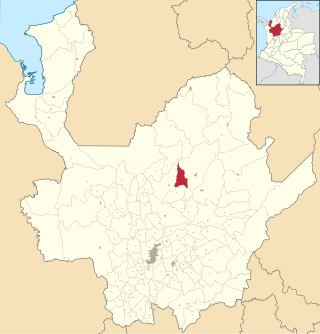
Campamento is a town and municipality in the Colombian department of Antioquia. Part of the subregion of Northern Antioquia, it lies at an altitude of 1,700 m above sea level. It is a little town, in the middle of the Andes.It borders on the north with the municipalities of Yarumal and Anorí, on the east with Anorí, on the south with the municipality of Angostura, and on the west with Yarumal.

Caucasia is a municipality located in the subregion of Bajo Cauca Antioquia department, in Colombia. Bounded on the south by the department of Córdoba, in the east by the municipalities of Antioquia in Nechí and El Bagre, on the north by the municipality of Zaragoza, and west to the town of Cáceres, and is located 270 km from Medellín.

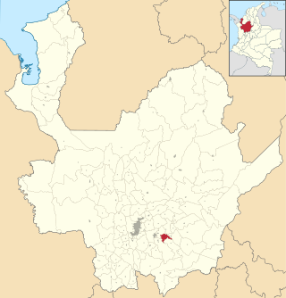
Concepción is a town and municipality in the Colombian department of Antioquia. It is part of the subregion of Eastern Antioquia and located 75km from Medellin.

Itagüí is a city and municipality of Colombia, located in the south of the Aburrá Valley in the Antioquia Department. It is part of the Metropolitan Area of the Aburrá Valley.

Jardín, is a town and municipality in the southwest region of Antioquia, Colombia. It is bounded by the Andes, Jericó, and Támesis municipalities to the north and the Caldas department to the south. The municipality is located between the San Juan River and a branch of the Western Cordillera. Jardín is identified by its preserved colonial architecture, lush vegetation, and abundant rivers and streams.
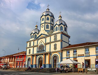
El Santuario is a town and municipality in the Antioquia Department, Colombia. It is part of the subregion of Eastern Antioquia. El Santuario was founded on 11 March 1765 by Captain Antonio Gómez de Castro. Its elevation is 2,150 meters above sea level, with an average temperature of 17 °C. The distance reference from Medellín city, the capital of Antioquia Department, is 57 km and it has a total area of 83.45 km². This town is well known for being the place where comedian Guillermo Zuluaga "Montecristo" and actor Crisanto Alonso Vargas "Vargasvil" were born. The more significant source of its economy is agriculture, mainly vegetables, beans, potatoes and legume cultivation.

Sonsón is a municipality in the Colombian department of Antioquia. Sonsón is located in Eastern Antioquia. It is one of the seats of the Roman Catholic Diocese of Sonsón–Rionegro. Sonsón celebrates "Las Fiestas Del Maíz"- during the month of August, being the most traditional, historical and representative festival in western Colombia. The population was estimated to be 33,598 in 2020.

Sopetrán is a municipality of Colombia, located in the subregion west of the state of Antioquia. It is bounded to the north by the municipality of Olaya, to the east by the municipality of Belmira, to the south by the municipalities of San Jerónimo and Ebéjico, and to the west by the municipality of Santa Fe de Antioquia. The population was 13,748 at the 2018 census. It is 59 kilometers from the city of Medellin, the state capital of Antioquia. The municipality of Sopetrán has an area of 223 square kilometers.

Yolombó is a town and municipality in the Colombian department of Antioquia. It is part of the subregion of Northeastern Antioquia, located 108 km from Medellín.

Rionegro is a city and municipality in Antioquia Department, Colombia, located in the subregion of Eastern Antioquia. The official name of the city is Ciudad Santiago de Arma de Rionegro. Rio Negro means "Black River" in Spanish, as the city received its name after a river that looks black because of the shadows cast by trees. The river traverses the city and it is the most prominent geographical feature of the municipality. Rionegro is also sometimes called the Cuna de la democracia as it was one of the most important cities during the era of the Colombia's struggle for independence and the 1863 constitution was written in the city.
Filandia is a town and municipality in the northern part of the department of Quindío, Colombia. It's located on the west side of Cordillera Central of the Andes mountain range running through central Colombia, 26 km north of the departmental capital Armenia. In 2023 the estimated population of Filandia was 12,596 inhabitants.

Turbo is a port city in Antioquia Department, Colombia. Part of the Urabá Antioquia sub-region, it is located on the coast of Gulf of Urabá, 340 km north of Medellín. This port city is the capital of the Urabá region of Antioquia. The place where Turbo is today was known as Pisisí, but by 1741 people were already talking about Turbo. By a decree on May 11, 1839, the central government spent one thousand pesos for military service barracks in Turbo. In 1840, the republican president assigned one thousand fanegas of uncultivated lands for the new population. It was established as a municipality in 1847.

Pácora is a town and municipality in the Colombian Department of Caldas. It is located in northern Caldas-Department, on the slopes of the Andes Central Mountains of the Republic of Colombia. With an average annual temperature of 18 °C, the town is bordered to the northeast with Aguadas, Caldas, to the south with Salamina, Caldas and La Merced, and to the west separated by the Cauca River, Marmato-Caldas and Caramanta-Antioquia department. The villages in Pácora are San Bartolomé, Castilla, Las Coles, Los Morros, San Lorenzo and Buenos Aires.
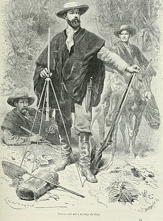
A ruana is a poncho-style outer garment native to the Colombian and Venezuelan Andes. In Colombia, the ruana is the characteristic and traditional garment of the department of Boyacá, initially made by indigenous and mestizo people, although it is also made in the departments of Cundinamarca, Antioquia, Nariño, Bogotá, Santander (Colombia), Norte de Santander and Caldas. In Venezuela it is widely used and made in the Andean states of Táchira, Mérida and Trujillo, used since the colonial times by all Venezuelan inhabitants, currently only in the Andean region its traditional use is maintained.


