Catlett, Virginia

Last updated

Catlett, Virginia
USA Virginia Northern location map.svg
Red pog.svg
Catlett
Location within Fauquier county
USA Virginia location map.svg
Red pog.svg
Catlett
Catlett (Virginia)
Usa edcp location map.svg
Red pog.svg
Catlett
Catlett (the United States)
Coordinates: 38°39′13″N77°38′26″W / 38.65361°N 77.64056°W / 38.65361; -77.64056
CountryUnited States
State Virginia
County Fauquier
Area
  Total3.24 sq mi (8.40 km2)
  Land3.22 sq mi (8.33 km2)
  Water0.03 sq mi (0.07 km2)
Elevation
270 ft (80 m)
Population
 (2010)
  Total297
  Density92/sq mi (35.5/km2)
Time zone UTC−5 (Eastern (EST))
  Summer (DST) UTC−4 (EDT)
ZIP code
20119
FIPS code 51-13624
GNIS feature ID1492729

Catlett is a census-designated place (CDP) in Fauquier County, Virginia, United States. The population as of the 2010 census was 297. [1] It is located west of the Prince William County line. Catlett was formerly a rail stop on the Orange and Alexandria Railroad, and the area was the site of many raids on the railroad during the American Civil War.

Contents

The Catlett Historic District was listed on the National Register of Historic Places in 2008, and Auburn Battlefield in 2011. [2] [3]

History

Thanks to the creation of a railroad system that was essential to travel and supply in Virginia, many small towns including Catlett sprung up as stops. During its heyday, Catlett was a busy telegraph outpost and mail stop along the Orange and Alexandria Railroad. The land that the town was built on had originally been granted to John Catlett in 1715, but was not named for him at first. The post office and town were first known as Colvin's Station after the Colvin family, but over the years this was changed to Catlett Station and then to simply Catlett. [4]

Catlett was the site of a pivotal skirmish in the Civil War between Major General J. E. B. Stuart of the Confederacy and the Union's Major General John Pope. [5] The Confederates raided the Union camp at Catlett on August 22, 1862, in an effort to disrupt the Union's rail supply lines. Stuart and his men began their attack during what Stuart referred to as the "darkest night I ever knew". He and his men rode into town and using sabers and fire were able to destroy the Federal encampment, cut telegraph wires, obtain wagons-full of supplies and capture almost 300 Union troops, but were unable to destroy the railroad bridge on the outskirts of the town. A heavy thunderstorm prevented them from burning it, so they attempted to use axes, but were turned away by Union riflemen. The most important prize that the Confederates gained were General Pope's orders, which contained critical information about the Union campaign. These orders were taken by Stuart to General Robert E. Lee and played a pivotal role in securing the South's victory in the Battle of Second Manassas. [5]

Later in the war, Colonel John S. Mosby conducted a raid with his cavalry unit in an attempt to disable an engine on the same rail line that Stuart had attacked in August 1862. This skirmish on May 20, 1863, went in favor of the superior numbers of the Union troops. Mosby's unit retreated after disabling the engine with a Howitzer cannon that they had captured the previous day. The Confederate troops took 5 fatalities, 20 injuries, and 10 men captured by the Federals. [6]

Geography

Catlett is located in southeastern Fauquier County, bordered to the southwest by Calverton. Virginia State Route 28 passes through the community, leading southwest through Calverton to Midland and Bealeton; to the northeast it leads through Nokesville in Prince William County to the city of Manassas. Warrenton, the Fauquier County seat, is 12 miles (19 km) to the northwest via local roads.

According to the U.S. Census Bureau, the Catlett CDP has a total area of 3.2 square miles (8.4 km2), of which 0.03 square miles (0.07 km2), or 0.84%, is water. [1] The western and southern edge of Catlett is formed by Cedar Run, a tributary of the Occoquan River, which flows southeast to the Potomac.

Demographics

According to the 2010 census the total population of Catlett is 297. The town is predominantly White, with 251 residents or 84.5% of the population. The second highest and only other race in Catlett is African-American, with 46 residents or 15.5% of the population. Data from the 2010 census shows no other ethnicities living in Catlett.

100% of the population of Catlett are citizens of the United States, with a median age of 56.2. The town has 144 households and is relatively wealthy, with a median household income of $78,198. [7]

Education

The citizens of Catlett are educated through Fauquier County Public Schools. H. M. Pearson Elementary School is located in Catlett. [8] Catlett is zoned for Cedar Lee Middle School and Liberty High School. [9] There are also many private schools both in Fauquier County and in neighboring Prince William County.

Public services

For fire fighting, Catlett like much of Fauquier County is served by Engine Company 7, which is equipped to fight both building and vehicular fires as well as brush fires and also has two ambulances. Engine Company 7, a volunteer organization of more than 80 participants, was formed by the merger of two organizations: the Catlett Volunteer Fire Company, organized in 1962, and the Cedar Run Volunteer Rescue Squad, organized in 1973. [10]

Development

Development has been stymied by the community's dense, moist "blackjack" soil type, [11] whose inability to perc well has resulted in one-third of the community's septic drain fields' failing. In December 2011, the county board of supervisors voted 3-2 to turn down a development proposal that called for building a large sewer system, capable of supporting 225 homes, 45 apartments and 85,000 square feet of commercial space, as a "proffer" in exchange for rezoning. [12] As of 2018, the costs of building sewers were estimated at $10.9 million. [13]

Politics

Catlett is in Virginia's 10th congressional district. It was previously in Virginia's 1st congressional district until 2023. It remains in Virginia's 31st House of Delegates district until redistricting, which occurred in 2021, takes effect in 2024, at which point it will join Virginia's 61st House of Delegates district. It will once again be in Virginia's 28th Senate district starting in 2024 after a hiatus in the 27th Senate district from 2011 until 2024. Catlett is in the Cedar Run district of the Fauquier County Board of Supervisors. [14]

Related Research Articles

<span class="mw-page-title-main">Fauquier County, Virginia</span> County in Virginia, United States

Fauquier County is a county in the Commonwealth of Virginia. As of the 2020 census, the population was 72,972. The county seat is Warrenton.

<span class="mw-page-title-main">Remington, Virginia</span> Town in Virginia, United States

Remington is a small incorporated town in Fauquier County, Virginia, United States. The population was 598 at the 2010 census. It is near the highways, U.S. Route 15, U.S. Route 17, U.S. Route 29, and Virginia State Route 28. Remington is less than a mile northeast of the Culpeper County line.

<span class="mw-page-title-main">Warrenton, Virginia</span> Town in Virginia, United States

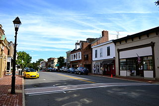
Warrenton is a town in Fauquier County, Virginia, of which it is the seat of government. The population was 10,057 as of the 2020 census, an increase from 9,611 at the 2010 census and 6,670 at the 2000 census. The estimated population in July 2021 was 10,109. It is at the junction of U.S. Route 15, U.S. Route 17, U.S. Route 29, and U.S. Route 211. The town is in the Piedmont region of Virginia just east of the Blue Ridge Mountains. The well-known Airlie Conference Center is 3 miles (5 km) north of Warrenton, and the historic Vint Hill Farms military facility is 9 miles (14 km) east. Fauquier Hospital is located in the town. Surrounded by Virginia wine and horse country, Warrenton is a popular destination outside Washington, D.C.

<span class="mw-page-title-main">Gainesville, Virginia</span> Census-designated place in Virginia, United States

Gainesville is a census-designated place (CDP) in western Prince William County, Virginia, United States. The population was 17,287 in the 2020 census.

<span class="mw-page-title-main">Nokesville, Virginia</span> Census-designated place in Virginia, United States

Nokesville is a Village and census-designated place (CDP) in Prince William County, Virginia, United States and Fauquier County, Virginia, United States. The population was 1,619 in the 2020 census.

<span class="mw-page-title-main">Mount Jackson, Virginia</span> Town in Virginia, United States

Mount Jackson is a town in Shenandoah County, Virginia, United States. The population was 1,994 at the 2010 census.

<span class="mw-page-title-main">Falmouth, Virginia</span> Census-designated place in Virginia, United States

Falmouth is a census-designated place (CDP) in Stafford County, Virginia, United States. Situated on the north bank of the Rappahannock River at the falls, the community is north of and opposite the city of Fredericksburg. Recognized by the U.S. Census Bureau as a census-designated place (CDP), Falmouth's population was 4,956 as of the 2020 census.

Bealeton is a census-designated place (CDP) in Fauquier County, Virginia, United States, at the intersection of U.S. Route 17 and State Route 28. The population was 4,435 at the 2010 census.

<span class="mw-page-title-main">Marshall, Virginia</span> Census-designated place in Virginia, United States

Marshall is a census-designated place (CDP) in northwestern Fauquier County, Virginia, in the United States. The population as of the 2010 census was 1,480.

<span class="mw-page-title-main">Virginia State Route 28</span> State highway in Virginia, United States

State Route 28 in the U.S. state of Virginia is a primary state highway that traverses the counties of Loudoun, Fairfax, Prince William, and Fauquier in the U.S. state of Virginia. The route serves as a major artery in the Northern Virginia region, with it being an important two-lane highway in rural Fauquier and Prince William Counties, the main thoroughfare through Manassas and Manassas Park, and a high-capacity freeway through Fairfax and Loudoun Counties.

<span class="mw-page-title-main">Second Battle of Auburn</span> Battle of the American Civil War

The Second Battle of Auburn was fought on October 14, 1863, in Fauquier County, Virginia, between Union and Confederate forces in the American Civil War. Confederate forces led by Lt. Gen. Richard S. Ewell led a sortie to extricate Maj. Gen. J.E.B. Stuart's cavalry command, trapped between two Union columns and clashed with the rearguard of the Federal II Corps under Brig. Gen. Gouverneur K. Warren. Stuart was successfully extricated but the Federal wagon train avoided Confederate capture in the inconclusive fight.

<span class="mw-page-title-main">Midland, Virginia</span> CDP in Virginia, United States

Midland is a census-designated place (CDP) in Fauquier County, Virginia, United States. The population as of the 2010 census was 218. Midland is home to a post office with the local ZIP code of 22728.

<span class="mw-page-title-main">Calverton, Virginia</span> Census-designated place in Virginia, United States

Calverton is a census-designated place (CDP) in Fauquier County, Virginia, United States. The population as of the 2010 census was 239. The village runs along Virginia State Route 28 and its crossroad, Bristersburg Road. Calverton has a Southern States store, a small country store, and post office. Its ZIP code is 20138.

<span class="mw-page-title-main">New Baltimore, Virginia</span> Census-designated place in Virginia, United States

New Baltimore is an unincorporated community and census-designated place (CDP) in eastern Fauquier County, Virginia, United States. The population as of the 2010 census was 8,119. The community has existed since the early 19th century, but it has had its most significant growth since the 1980s. It is the portion of Fauquier County with the easiest access to Washington, D.C., and as a result, many people who live in New Baltimore commute into DC. Other major communities close to New Baltimore are Warrenton, Gainesville/Haymarket area, and Manassas. The area officially considered to be New Baltimore expanded significantly in 2006 with Fauquier County's designation of service districts, of which New Baltimore is one. The service district designation provides added access to utilities such as water and sewer, and targets the area for growth.

<span class="mw-page-title-main">R. Taylor Scott</span> American lawyer

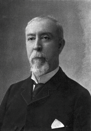
Robert Taylor Scott was a Virginia lawyer, politician and Confederate officer. Elected three times as Attorney General of Virginia, Scott also served one term in the Virginia House of Delegates and several terms as mayor of Warrenton, Virginia.

<span class="mw-page-title-main">John Quincy Marr</span> Confederate States Army first combat casualty (1825–1861)

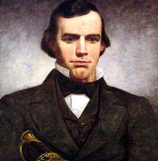
John Quincy Marr was a Virginia militia company captain and the first Confederate soldier killed by a Union soldier in combat during the American Civil War. Marr was killed at the Battle of Fairfax Court House, Virginia on June 1, 1861. Previously one of Fauquier County's two delegates to the Virginia Secession Convention of 1861, Marr initially opposed his state's secession from the Union but ultimately supported secession, as did voters shortly before his fatal skirmish.

<span class="mw-page-title-main">Timeline of Fauquier County, Virginia in the Civil War</span>

Timeline of Fauquier County, Virginia in the Civil War

<span class="mw-page-title-main">Delaplane Historic District</span> Historic district in Virginia, United States

Delaplane Historic District is a national historic district located at Delaplane, Fauquier County, Virginia.

<span class="mw-page-title-main">Warrenton Historic District (Warrenton, Virginia)</span> Historic district in Virginia, United States

Warrenton Historic District is a national historic district located at Warrenton, Fauquier County, Virginia. It encompasses 288 contributing buildings in the central business district and surrounding residential areas of the county seat of Warrenton. Notable buildings include the old Fauquier County courthouse (1890), Fauquier County Administration Building (1928), the former Fauquier County Public Library (1923), Fauquier National Bank (1925), "Paradise" (1758), the Thomas L. Moore House (1816), the James Caldwell House (1831), the John Quincy Marr House (1830), the Marshall Building, the California Building, old Town Hall (1854), Warrenton Presbyterian Church (1855), Ullman's Store, and "Mecca" (1859). Also located on the district are the separately listed Brentmoor and Old Fauquier County Jail.

<span class="mw-page-title-main">Warrenton Junction Raid</span> Cavalry skirmish in Virginia during the American Civil War

The Warrenton Junction Raid was a surprise attack by Confederate guerrilla warriors on a Union cavalry detachment during the American Civil War. The raid took place near a railroad junction in Virginia's Fauquier County, less than 10 miles (16 km) from the town of Warrenton. Confederate Major John S. Mosby led the attack against about 100 men from the Union's 1st (West) Virginia Cavalry. At first, the raid was very successful, as many of the Union soldiers surrendered to the rebels. The remaining portion of the surprised force was surrounded in a house, and two of their leaders were wounded. The house was set on fire, and the Union soldiers surrendered. As Mosby's men rounded up prisoners and horses, a detachment of the 5th New York Cavalry surprised the rebels and rescued most of the captured Union soldiers. After a short fight, more men from the 5th New York, and the 1st Vermont Cavalry, joined in the pursuit of Mosby's fleeing rebels.

References

Notes

  1. 1 2 "Geographic Identifiers: 2010 Demographic Profile Data (G001): Catlett CDP, Virginia". U.S. Census Bureau, American Factfinder. Retrieved October 18, 2016.[ dead link ]
  2. "National Register Information System". National Register of Historic Places . National Park Service. July 9, 2010.
  3. "National Register of Historic Places Listings". Weekly List of Actions Taken on Properties: 8/09/10 through 8/13/10. National Park Service. December 23, 2011.
  4. "National Register of Historic Places Registration Form: Catlett Historic District" (PDF). United States Department of the Interior: National Park Service. January 9, 2008 via Virginia Department of Historic Resources.
  5. 1 2 "The Battle of Catlett's Station". www.mycivilwar.com. Retrieved August 11, 2019.
  6. "Catlett Station and Warrenton Junction, Virginia site photos". Archived from the original on July 28, 2017. Retrieved April 25, 2017.
  7. "Catlett, VA | Data USA". datausa.io. Retrieved August 11, 2019.
  8. "Pearson Elementary - Pearson Home". Archived from the original on March 22, 2014. Retrieved March 22, 2014.
  9. "Login - Tyler's Versatrans eLink". transportation.fcps1.org. Retrieved August 11, 2019.
  10. "Fauquier Volunteer Fire Rescue Association: Volunteer Companies". Fauquier County Department of Fire, Rescue & Emergency Management. Retrieved June 15, 2018.
  11. "Firm abandons sewer plan for Catlett and Calverton". Fauquier Now. Retrieved August 11, 2019.
  12. "County seeks to offset huge costs in Catlett, Calverton". Fauquier Now. Retrieved August 11, 2019.
  13. "Catlett, Calverton sewer costs soar to $10.9 million". Fauquier Now. Retrieved August 11, 2019.
  14. "Fauquier County Polling Place Locations". Fauquier County Virginia. Retrieved October 30, 2022.

Sources