Fauquier is a county in the Commonwealth of Virginia. As of the 2010 census, the population was 65,203. The county seat is Warrenton.
Idylwood is a census-designated place (CDP) in Fairfax County, Virginia, United States. The population was 17,288 at the 2010 census. It originally developed as a suburban community along the route of the Washington and Old Dominion Railroad, and later along Virginia State Route 7. The construction of the Capital Beltway in the 1960s, and I-66 and the Orange Line of the Washington Metrorail system in the 1980s, as well as the concurrent development of nearby Tysons Corner into Washington's leading suburban business district, led to the development of several apartment, townhouse, and small-lot single-family housing complexes, as well as the high-rise Idylwood Towers condominium, in the portion of Idylwood lying to the north of I-66. The area to the south of I-66 remains primarily large-lot single-family.
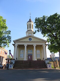
Warrenton is a town in Fauquier County, Virginia, United States. The population was 9,611 at the 2010 census, up from 6,670 at the 2000 census. The estimated population in 2018 was 9,937. Warrenton is the county seat of Fauquier County. It is at the junction of U.S. Route 15, U.S. Route 17, U.S. Route 29, and U.S. Route 211. The town is in the Piedmont region of Virginia, just east of the Blue Ridge Mountains. The well-known Airlie Conference Center is 3 miles (5 km) north of Warrenton, and the historic Vint Hill Farms military facility is 9 miles (14 km) east. Fauquier Hospital is located in the town. Surrounded by Virginia wine and horse country, Warrenton is a popular destination outside Washington, D.C.

Falmouth is a census-designated place (CDP) in Stafford County, Virginia, United States. Situated on the north bank of the Rappahannock River at the falls, the community is north of and opposite the city of Fredericksburg. Recognized by the U.S. Census Bureau as a census-designated place (CDP), Falmouth's population was 4,274 as of the 2010 census.

Bealeton is a census-designated place (CDP) in Fauquier County, Virginia, United States, at the intersection of U.S. Route 17 and State Route 28. The population was 4,435 at the 2010 census.

Catlett is a census-designated place (CDP) in Fauquier County, Virginia, United States. The population as of the 2010 census was 297. It is located west of the Prince William County line. Catlett was formerly a rail stop on the Orange and Alexandria Railroad, and the area was the site of many raids on the railroad during the American Civil War.

Marshall is a census-designated place (CDP) and unincorporated town in northwestern Fauquier County, Virginia, in the United States. The population as of the 2010 census was 1,480.

Goochland is a census-designated place (CDP) in and the county seat of Goochland County, Virginia, United States. The population as of the 2010 census was 861. The community is also known as Goochland Courthouse or by an alternative spelling, Goochland Court House. It derives its name from the fact that the community is the location of the county's court house.

Calverton is an unincorporated community and census-designated place (CDP) in Fauquier County, Virginia, United States. The population as of the 2010 census was 239. The village runs along Virginia State Route 28 and its crossroad, Bristersburg Road. Calverton has a Southern States store, a small country store, and post office. Its ZIP code is 20138.
New Baltimore is an unincorporated community and census-designated place (CDP) in eastern Fauquier County, Virginia, United States. The population as of the 2010 census was 8,119. The community has existed since the early 19th century, but it has had its most significant growth since the 1980s. It is the portion of Fauquier County with the easiest access to Washington, D.C., and as a result, many people who live in New Baltimore commute into DC. Other major communities close to New Baltimore are Warrenton, Gainesville/Haymarket area, and Manassas. The area officially considered to be New Baltimore expanded significantly in 2006 with Fauquier County's designation of service districts, of which New Baltimore is one. The service district designation provides added access to utilities such as water and sewer, and targets the area for growth.

Opal is an unincorporated community and census-designated place (CDP) in Fauquier County, Virginia, United States. It is on U.S. Highway 15/U.S. Route 17 and U.S. Route 29, at an elevation of 449 feet (137 m). The population as of the 2010 census was 691.

Ravensworth is a census-designated place in Fairfax County, Virginia, United States. The population as of the 2010 census was 2,466. It is part of the Washington metropolitan area. The Ravensworth Farm subdivision was developed in the early 1960s on land that for centuries had been the Ravensworth estate.

Crosspointe is a census-designated place in Fairfax County, Virginia, United States. The population as of the 2010 census was 5,802.
Kings Park West is a census-designated place in the eastern United States, in Fairfax County, Virginia, southwest of Washington, D.C. The population as of the 2010 census was 13,390.
Long Branch is a census-designated place in Fairfax County, Virginia, bordering the city of Fairfax. The population as of the 2010 census was 7,593.

McNair is a census-designated place located in the Oak Hill section of Fairfax County, Virginia, United States. It is directly to the east of Washington Dulles International Airport. The population as of the 2010 census was 17,513. Much of the population resides in the McNair Farms planned community. The community has a school called McNair Elementary.

South Run is a census-designated place in Fairfax County, Virginia, United States. The population as of the 2010 census was 6,389.

Wakefield is a census-designated place in Fairfax County, Virginia, United States. The population as of the 2010 census was 11,275.

Woodburn is a census-designated place in Fairfax County, Virginia, United States. The population as of the 2010 census was 8,480.

John Marshall Birthplace Park is a small park located in the historic Germantown area in southern Fauquier County, Virginia. The park provides access to a dedication monument at or near the birthplace of John Marshall.