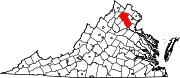
Fauquier County is a county in the Commonwealth of Virginia. As of the 2020 census, the population was 72,972. The county seat is Warrenton.

The Plains is a small incorporated town in Fauquier County, Virginia, United States. The population was 245 as of the 2020 census, up from 217 at the 2010 census. It is centered on the intersection of VA 55 and VA 245. The town of The Plains is situated off I-66. As of 2022, the mayor of The Plains is Lori Sisson.

Hillsboro is a rural town in Loudoun County, Virginia, United States. The population was 114 at the 2020 census.

Middleburg is a town in Loudoun County, Virginia, United States, with a population of 673 as of the 2010 census. It is the southernmost town along Loudoun County's shared border with Fauquier County.

The Battle of Aldie took place on June 17, 1863, in Loudoun County, Virginia, as part of the Gettysburg Campaign of the American Civil War.
Unison is an unincorporated community village in Loudoun County, Virginia. It is located approximately five miles from Middleburg in the Loudoun Valley close to the Fauquier County border.

Blue Ridge Mountain, also known as Blue Mountain, is the colloquial name of the westernmost ridge of the Blue Ridge Mountains in northern Virginia and the Eastern Panhandle of West Virginia. The Appalachian Trail traverses the entire length of the mountain along its western slope and crest.

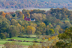
Aldie is an unincorporated community and census-designated place (CDP) located between Chantilly and Middleburg in Loudoun County, Virginia, United States. The historic village of Aldie is located on the John Mosby Highway in a gap between the Catoctin Mountains and Bull Run Mountains, through which the Little River flows. Aldie traditionally serves as the gateway to the Loudoun Valley and beyond.

Buildings, sites, districts, and objects in Virginia listed on the National Register of Historic Places:

Ashby Gap, more commonly known as Ashby's Gap is a wind gap in the Blue Ridge Mountains on the border of Clarke County, Loudoun County and Fauquier County in Virginia. The gap is traversed by U.S. Route 50. The Appalachian trail also passes across the gap.

The Loudoun Valley is a small, but historically significant valley in the Blue Ridge Mountains located in Loudoun County in Northern Virginia in the United States.

U.S. Route 50 is a transcontinental highway which stretches from Ocean City, Maryland to West Sacramento, California. In the U.S. state of Virginia, US 50 extends 86 miles (138 km) from the border with Washington, D.C. at a Potomac River crossing at Rosslyn in Arlington County to the West Virginia state line near Gore in Frederick County.
Little River is a 23.4-mile-long (37.7 km) tributary stream of Goose Creek in Fauquier and Loudoun counties in Northern Virginia. Via Goose Creek, it is a tributary of the Potomac River.

Delaplane is a small unincorporated village in northern Fauquier County, Virginia, approximately 50 miles (80 km) due west of Washington, D.C. Delaplane is situated along U.S. Route 17, U.S. Route 50, and Interstate 66; bordering Upperville, Virginia to the north, Hume, Virginia to the south, Paris, Virginia to the west, and Rectortown, Virginia to the east. Delaplane, Virginia has a ZIP Code of 20144.
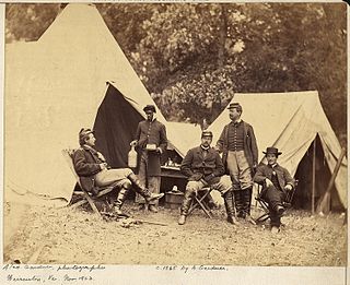
Timeline of Fauquier County, Virginia in the Civil War

Delaplane Historic District is a national historic district located at Delaplane, Fauquier County, Virginia.

Paris Historic District is a national historic district located at Paris, Fauquier County, Virginia. It encompasses 53 contributing resources in the rural village of Paris. The district includes primarily residences, although the district also includes some commercial buildings, churches, a former school, and a cemetery. Fifty-two of the 53 contributing resources are already listed as part of the Crooked Run Valley Rural Historic District. Notable buildings include "Wagoner's Stand", the Josiah Murray House, the William Peck House, Old Paris Meeting House, the Willis-Carr House, the former Rogers Store, and Trinity United Methodist Church (1892).
The Carolina Road or the "Old Carolina Road" are names for various sections of the Great Wagon Road and other routes in colonial America. "The 'Old Carolina Road', extending from Lancaster, Pennsylvania to the Yadkin Valley, was one of the most heavily traveled roads in eighteenth century America." Parts of the 180-mile-long (290 km) Journey Through Hallowed Ground National Heritage Area scenic byway follow the Old Carolina Road through Pennsylvania, Maryland and Virginia.

Edward Carrington Marshall was a Virginia farmer, planter, businessman, and politician. He represented Fauquier County in the Virginia House of Delegates 1834-1838 and became president of the Manassas Gap Railroad.
Alexander John Marshall was a Virginia lawyer, businessman and politician who served many years as Clerk of Fauquier County, helped secure construction of the Rappahannock Canal, and was a Virginia state senator during the American Civil War (1862–1865).