Ceres, Washington

Last updated

Ceres, Washington
Former community, locale
USA Washington location map.svg
Red pog.svg
Ceres
Usa edcp location map.svg
Red pog.svg
Ceres
Coordinates: 46°36′28″N123°09′12″W / 46.60778°N 123.15333°W / 46.60778; -123.15333
Country United States
State Washington
County Lewis
Elevation
240 [1]  ft (73 m)
Time zone UTC-8 (Pacific (PST))
  Summer (DST) UTC-7 (PDT)
ZIP code
98532
Area code 360

Ceres, also known as Ceres Hill, was a former farming and railroad depot community and is a locale in Lewis County, in the U.S. state of Washington. [2] The area is located off Washington State Route 6 in a bend of the Chehalis River. The Willapa Hills Trail bisects the former community. [3]

Contents

History

The area began with a train depot known as Long's Crossing and was a rail stop on the South Bend line for Northern Pacific Railroad. Across from the station, the town grew to include a general store. [4] The community was eventually named by the Northern Pacific Railroad after Ceres, the Roman goddess of agriculture, due to the fertile soil in the area. [5] [6] [7] By the late 1890s, the rail stop became known as Ceres station, and the first iteration of the Ceres Bridge was constructed at the turn of the 20th century. [8] [9] [10]

In the 1890s, the area became a logging site and a splash dam was built in 1897, but destroyed later that year after a large flood event. [11] [12] A steamboat, named the "Carrie Davis", operated out of Ceres during its early history, ferrying passengers and goods to the Skookumchuck River. [13] [14] [lower-alpha 1]

Ceres began to grow in the new century, with the build of a grocery store in August 1908; [15] the post office was established in the store in October of that year. [16] Telephone lines were installed in 1911 to "intermediate houses of note", with reports that Ceres residents were delighted. [17] Timber harvesting continued in the community into the late 1910s, with the area supporting a logging camp. [18] Peaking in the 1920s, Ceres residents began the Ceres Improvement Club, which had their own hall. [19] [20]

Known as an agriculture community with a small population, [5] Ceres was often described as a farming district beginning in the 1920s, [21] [22] and sometimes referred to as a neighborhood. [23] By the 1930s, Ceres became synonymous with the moniker, Ceres Hill, and and reporting in the 1960s classified the community as an area. [24]

After disastrous floods to the region due to the Great Coastal Gale of 2007, reporting provided details on infrastructure and residential damages in the Ceres Hill Road area, but does not mention Ceres as a town or community. [25]

Post office

A post office called Ceres was established in 1908 inside the newly constructed grocery store, [16] and remained in operation until 1931. [26] The office began as a pigeon-hole messagebox [4] but by the 1920s, the Ceres postmaster was in charge of a route that delivered mail three days a week to surrounding towns such as Boistfort, the neighboring communities of Doty and Dryad, and went as far west as Pe Ell. Residents could sign up with the Ceres office, and postal workers were legally required to exchange and deliver mail from registered members on the route. [27]

By 1930, the route was removed and mail was available for pickup in Chehalis; [28] the Ceres postmaster resigned at the end of the year. Attempts were made to hire a new head of the post office, [29] and the Ceres route was reintegrated to the Chehalis delivery circuit, but a new Ceres postmaster was never hired as "the compensation is so small no one will take the position permanently". [30] The Ceres post office was officially announced as closed, May 29, 1931. [31]

Geography

Ceres is located approximately 12 miles (19 km) west of Chehalis and the area is known for its fertile soil. [32] In the early days of settlement, the region in which Ceres is located was referred to as King's prairie. [14]

Education

The Ceres community is first mentioned as having a school in 1900, where a musical performance was held by students from the state juvenile detention center, Green Hill School. [33] By 1910, Ceres hosted two schools and districts, given the numbers 67 and 138. The Ceres school No. 67 was part of consolidated district, but legally separated from such in 1917 and joined with No. 138. [34] [35] The student population was never large, with the total amount of pupils once recorded as 15 in 1918. [36] The school closed before the 1936-1937 school year as a new road built by the Public Works Administration allowed Ceres students to travel to nearby Klaber, Washington. [37]

Economy

The region was known for its farming and agricultural use. Ceres was particularly known for the cultivation of hops [5] [38] , with a farmer once receiving an award from a show in New York City. [39] Ceres was also a large producer of prized Holstein cows, [40] setting a world record in 1933 for the number of birthed calves. [41]

Notes

  1. The dates the steamer operated are unclear but it was owned by an early pioneer in the Adna-Claquato region, J.T. Browning. See source listed.

Related Research Articles

<span class="mw-page-title-main">Lewis County, Washington</span> County in Washington, United States

Lewis County is a county in the U.S. state of Washington. As of the 2020 census, the county's population was 82,149. The county seat is Chehalis, and its largest city is Centralia. Lewis County comprises the Centralia, WA Micropolitan Statistical Area, which is also included in the Seattle-Tacoma, WA Combined Statistical Area.

<span class="mw-page-title-main">Chehalis, Washington</span> City in Washington, United States

Chehalis is a city in and the county seat of Lewis County, Washington, United States. The population was 7,439 at the time of the 2020 census.

<span class="mw-page-title-main">Adna, Washington</span> Unincorporated community in Washington, United States

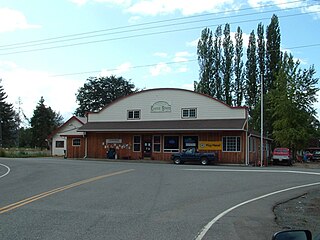
Adna is an unincorporated community located in Lewis County, Washington.

<span class="mw-page-title-main">Chehalis–Centralia Railroad</span>

The Chehalis–Centralia Railroad (CHTX) is a heritage railroad based in Chehalis, Washington.

<span class="mw-page-title-main">Washington State Route 6</span> State highway in Washington, United States

State Route 6 (SR 6) is a 51.37-mile (82.67 km) long state highway in Pacific and Lewis counties in the U.S. state of Washington. The highway, which extends from U.S. Route 101 (US 101) in Raymond east to Interstate 5 (I-5), co-signed with US 12, in Chehalis. Major communities located on the highway include Raymond, Pe Ell, Adna and Chehalis. The first state highway that used the current route of SR 6 was State Road 19, established in 1913. State Road 19 became State Road 12 in 1923, which became Primary State Highway 12 (PSH 12) in 1937. In 1964, PSH 12 became SR 6 and since, three minor construction projects have been arranged, only two have been completed.

<span class="mw-page-title-main">Curtis, Washington</span> Unincorporated community in Washington, United States

Curtis is an unincorporated community in Washington. It is located less than 3-miles north of Boistfort and is south of Washington State Route 6. The South Fork Chehalis River flows thru the town.

<span class="mw-page-title-main">Rainbow Falls State Park</span>

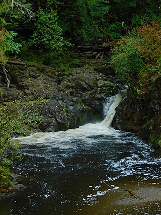
Rainbow Falls State Park is a public recreation area on the Chehalis River. It is situated off Washington State Route 6 and is approximately 1.0-mile (1.6 km) east of the town of Dryad, Washington.

<span class="mw-page-title-main">Littell, Washington</span> Unincorporated community in Washington, United States

Littell is an unincorporated community in Lewis County, Washington, United States, located off Washington State Route 6 between the towns of Adna and Claquato.

Cora is an unincorporated community in Lewis County, Washington, United States.

<span class="mw-page-title-main">McCormick, Washington</span> Unincorporated community in Washington, United States

McCormick is an unincorporated community off Washington State Route 6 in Lewis County, in the U.S. state of Washington.

Meskill is an unincorporated community off Washington State Route 6 in Lewis County, Washington. The town is located near Rainbow Falls State Park, and rests between Ceres and Dryad. The Willapa Hills Trail bisects the area.

Wildwood is an unincorporated community in Lewis County, in the U.S. state of Washington. The town is located between Boistfort and Vader. The community's early days, similar to other areas in Lewis County, had an economy driven by lumber production however it has retained its predominant agricultural roots. The area is known for its elk hunting.

Parks and recreation in Chehalis, Washington is administered by the Chehalis Parks and Recreation Department. Trails that connect Chehalis with locations beyond the city limits are maintained in conjunction with other local jurisdictions, state government agencies, and/or local non-profit groups and volunteers.

<span class="mw-page-title-main">Millett Field</span> Public park in Chehalis, Washington

Millett Field is the oldest, continuously used public park in Chehalis, Washington and is most noted as home to a Chehalis minor-league baseball team in the early 20th century. The ballfield was regularly used as the central hub of Chehalis sporting activity for decades, including hosting games for several Negro League teams in the 1920s. Located in the city's South Market district, one block north of the NRHP-listed O. B. McFadden House, the 3.3-acre (1.3 ha) park began in 1898.

<span class="mw-page-title-main">Lintott-Alexander Park</span> Park in Chehalis, Washington

Lintott-Alexander Park is a 6-acre (2.4 ha) park in Chehalis, Washington, located west of I-5 and south of Washington State Route 6. Due to its location in a bend of the Chehalis River and at the confluence of the Newaukum River, the park can flood in most years.

John Dobson and McFadden Parks were once the center of the Chehalis, Washington park system and they were referred to by residents as the "Top-of-the-Hill" parks due to their proximity to one another. They are the two oldest non-athletic parks in Chehalis. Begun as memorials to well respected Chehalis residents, they are located in the Hillside district on Park Hill, above and east of the historic downtown. The parks are connected by the Dobson-McFadden Trail.

<span class="mw-page-title-main">Willapa Hills Trail</span>

The Willapa Hills Trail is a 56.0-mile (90.1 km) intercounty rail trail in the U.S. state of Washington that is part of the Willapa Hills State Park. Following an east–west route alongside State Route 6, the tract links Chehalis and South Bend, traveling through or near several small towns and parks along the way. Overseen by the Washington State Parks and Recreation Commission, local cities and towns often maintain areas of the trail within their jurisdictions. The trail is built upon a decommissioned railroad track.

<span class="mw-page-title-main">Winston, Washington</span> Unincorporated community in Washington, United States

Winston, also known as Winston Creek, is an unincorporated community located in Lewis County, Washington. The rural, residential community sits in the mid-south area of Lewis County and is 3.0 miles (4.8 km) southeast of Mayfield and 4.0 miles (6.4 km) northeast of Wilson.

<span class="mw-page-title-main">Flood history in Chehalis, Washington</span>

The city of Chehalis is located in Washington state and rests upon the Chehalis River. Due to the city's location in the Chehalis Valley and the nearby confluences of the Newaukum River south of Chehalis and the Skookumchuck River in neighboring Centralia, the community has suffered from numerous floods. Some floods have occurred resulting from overflows of creeks and minor tributaries in the Chehalis river basin, and severe cresting of the Cowlitz River has occasionally led to flooding in the Chehalis area.

Harmony is an unincorporated town in Lewis County, Washington. The community is located near the junction of the Cowlitz River and Mayfield Lake, and is situated off Route 122, north of Mossyrock.

References

  1. U.S. Geological Survey Geographic Names Information System: Ceres, Washington
  2. U.S. Geological Survey Geographic Names Information System: Ceres, Washington
  3. "Willapa Hills State Park Trail". parks.state.wa.us. Washington State Parks. Archived from the original on July 28, 2021. Retrieved December 12, 2021.
  4. 1 2 "The Sou'wester - Summer & Fall 2006". Pacific County Historical Society and Museum (Volume XLII, Numbers 2 & 3 ed.). 2006. p. 12. Archived from the original on March 20, 2014. Retrieved May 28, 2024.{{cite magazine}}: CS1 maint: bot: original URL status unknown (link)
  5. 1 2 3 "If Towns Could Talk - Meskill-Ceres". The Chronicle. March 30, 2002. pp. A1, A12. Retrieved May 30, 2024.
  6. Meany, Edmond S. (1923). Origin of Washington geographic names. Seattle: University of Washington Press. p. 42.
  7. "Lewis County Towns - Ceres". jtenlen.drizzlehosting.com. Lewis Co. WA GenWeb Project.
  8. "Over The County". The Chehalis Bee-Nugget. December 29, 1899. p. 1. Retrieved May 30, 2024.
  9. "Their Last Session". The Chehalis Bee-Nugget. January 11, 1901. p. 21. Retrieved May 30, 2024.
  10. "Lots Of Business". The Chehalis Bee-Nugget. June 12, 1903. p. 1. Retrieved May 30, 2024.
  11. "No title". The Chehalis Bee. February 12, 1897. p. 11. Retrieved May 30, 2024. Third column, near middle
  12. "Press Comment". The Chehalis Bee. December 3, 1897. p. 1. Retrieved May 30, 2024. Bottom of far right column
  13. "Pioneer group members learn about steamer owner". The Chronicle (Centralia, Washington) . May 8, 2004. Retrieved May 30, 2024.
  14. 1 2 "J.T. Browning Noted Pioneer". The Chehalis Bee-Nugget. June 15, 1911. p. 2. Retrieved May 30, 2024.
  15. "Store At Ceres". The Chehalis Bee-Nugget. August 7, 1908. p. 19. Retrieved May 30, 2024.
  16. 1 2 "Centralia". The Centralia Daily Chronicle. October 13, 1908. p. 3. Retrieved May 30, 2024. See 2nd column
  17. "New Phone Line Granted By Board". The Centralia Daily Chronicle. January 6, 1911. p. 1. Retrieved May 30, 2024.
  18. Loyal Legion of Loggers and Lumbermen - Monthly Bulletin. Loyal Legion of Loggers and Lumbermen. 1918. p. 22. Retrieved May 30, 2024.
  19. "Ceres News". The Chehalis Bee-Nugget. February 5, 1926. p. 3. Retrieved May 30, 2024.
  20. "Ceres News". The Chehalis Bee-Nugget. June 19, 1925. p. 2. Retrieved May 30, 2024.
  21. "The Chehalis City Election Is Held Monday, December 6". The Chehalis Bee-Nugget. December 3, 1920. p. 1. Retrieved May 30, 2024.
  22. "Genuine Co-operation Need In This State". The Chehalis Bee-Nugget. February 13, 1931. p. 6. Retrieved May 30, 2024. 2nd column
  23. "Deaths Reported This Week - I.N. Land". The Chehalis Bee-Nugget. October 17, 1924. p. 37. Retrieved May 30, 2024.
  24. "Bold Theft Reported". The Daily Chronicle. March 27, 1969. p. 1. Retrieved May 30, 2024.
  25. Schwartz, Eric (March 21, 2008). "A Tour of Recovery". The Chronicle. Retrieved May 30, 2024.
  26. "Post Offices". Jim Forte Postal History. Archived from the original on March 6, 2016. Retrieved July 22, 2016.
  27. "Ceres Rural". The Chehalis Bee-Nugget. January 25, 1924. p. 12. Retrieved May 30, 2024.
  28. "Ceres Rural Route to Be Out of Chehalis P.O." The Chehalis Bee-Nugget. May 2, 1930. p. 1. Retrieved May 30, 2024.
  29. "Will Hold Examination of Postmaster at Ceres". The Chehalis Bee-Nugget. December 12, 1930. p. 21. Retrieved May 30, 2024.
  30. "To Extend Route 4 Into Ceres District". The Chehalis Bee-Nugget. February 20, 1931. p. 1. Retrieved May 30, 2024.
  31. "Town Talk". The Chehalis Bee-Nugget. May 30, 1931. p. 11. Retrieved May 30, 2024. 2nd column
  32. "Ceres Fertile Spot". The Centralia Daily Chronicle. August 26, 1941. p. 43. Retrieved May 29, 2024.
  33. "Over The County". The Chehalis Bee-Nugget. August 17, 1900. p. 8. Retrieved May 30, 2024.
  34. "Boistfort Valley was site of state's first public school in 1850s". The Daily Chronicle. July 2, 1976. p. D15. Retrieved May 30, 2024.
  35. "Ceres Withdraws From 204". The Chehalis Bee-Nugget. May 18, 1917. p. 2. Retrieved May 30, 2024.
  36. "Adna Fair List". The Chehalis Bee-Nugget. May 31, 1918. p. 2. Retrieved May 30, 2024.
  37. "PWA Money For Bridge Received". The Centralia Daily Chronicle. March 23, 1936. p. 3. Retrieved May 30, 2024.
  38. "Hop Picking Season Is Here". The Centralia Daily Chronicle Examiner. September 3, 1915. p. 6. Retrieved May 30, 2024.
  39. "Local Hops Win Prizes". The Chehalis Bee-Nugget. December 5, 1912. p. 1. Retrieved May 30, 2024.
  40. "Chamberlain Bull From Good Stock". The Centralia Daily Chronicle. July 22, 1930. p. 3. Retrieved May 30, 2024.
  41. "Sow Is Prolific". The Centralia Daily Chronicle. April 25, 1933. p. 2. Retrieved May 30, 2024.