External links
47°48′25″N83°23′28″W / 47.80694°N 83.39111°W / 47.80694; -83.39111
| International | |
|---|---|
| National | |
| | This Northern Ontario geographical article is a stub. You can help Wikipedia by expanding it. |
Chapleau Ojibway First Nation is an Ojibwa First Nation located near Chapleau Township, Sudbury District, Ontario, Canada. The First Nation have reserved for themselves the 67 ha Chapleau 61A Indian Reserve, 64.7 ha Chapleau 74 Indian Reserve and the 799.3 ha Chapleau 74A Indian Reserve. In September, 2007, their total registered population 39, of which their on-reserve population was 30 (24 on their main Reserve).
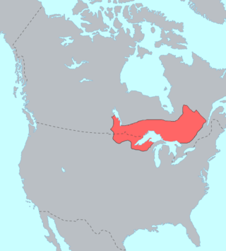
The people of Chapleau Ojibwe First Nation live on the only Ojibwa-language reserve in the Chapleau area. Their historical kinship and relationship with the land therefore draws them west to the shores of Lake Superior and south to the shores of Lake Huron, rather than north into Cree territory to the shores of James Bay. As such, much of their traditional territory was ceded to the Crown under the 1850 Robinson Treaties. These treaties cover all land whose waters drain into the north shores of lakes Huron and Superior. Chapleau Ojibwe forefathers were not, however, signatories to the Robinson Treaties, partly because William Benjamin Robinson did not take the time to meet with inland First Nation communities and partly because inland First Nation leaders were reluctant to travel as a result of a cholera outbreak in 1849.
After visiting Chapleau in 1905, the Treaty 9 commissioners reported that it would not be necessary to negotiate a treaty with the Indian people of Chapleau as they belonged to bands residing at Moose Factory, English River and other places already under treaty. Treaty 9 covers all land in the Chapleau are that drains north into James Bay. Since large reserves had already been established in other parts of the province for the bands from which people at Chapleau had immigrated, the commissioners recommended that a small area be set aside for Chapleau Ojibwe so that they could build small houses and cultivate garden plots. The Chapleau Ojibway Reserve was established in 1950.
The First Nation is led by Chief Anita Stephens and two Councillors: Johanne Wesley and Joshua Memegos. Chapleau Ojibway First Nation is member of Wabun Tribal Council, a regional tribal council affiliated with the Nishnawbe Aski Nation.
Chapleau Ojibway First Nation is policed by the Nishnawbe-Aski Police Service, an Aboriginal-based service.
47°48′25″N83°23′28″W / 47.80694°N 83.39111°W
| International | |
|---|---|
| National | |
| | This Northern Ontario geographical article is a stub. You can help Wikipedia by expanding it. |
The Ojibwe, Ojibwa, Chippewa, or Saulteaux are an Anishinaabe people in what is currently southern Canada, the northern Midwestern United States, and Northern Plains. They are Indigenous peoples of the Subarctic and Northeastern Woodlands.
Aroland First Nation is a Ojibwa, Oji-Cree and cree First Nation within the Nishnawbe Aski Nation Territory and a signatory to Treaty 9, located in the Thunder Bay District approximately 20 kilometres west of Nakina. Aroland First Nation, has Indian reserve status, though the settlement itself is not a reserve. The Aroland First Nation is also a member of the Matawa First Nations Tribal Council.
Mishkeegogamang First Nation is an Ojibway band government in the Canadian province of Ontario. Until 1993, the band was called the Osnaburgh First Nation, with various settlements at times being called New Osnaburgh, Osnaburgh House, or Osnaburgh.
Garden River First Nation, also known as Ketegaunseebee, is an Ojibwa band located at Garden River 14 near Sault Ste. Marie, Ontario, Canada.
Wapekeka First Nation is a First Nation band government in the Canadian province of Ontario. An Oji-Cree community in the Kenora District, the community is located approximately 450 kilometres northeast of Sioux Lookout. In January, 2008, the total registered population was 375, of which the on-reserve population was 355.
The Robinson Treaties are two treaties signed between the Ojibwa chiefs and the Crown in 1850 in the Province of Canada. The first treaty involved Ojibwa chiefs along the north shore of Lake Superior, and is known as the Robinson Superior Treaty. The second treaty, signed two days later, included Ojibwa chiefs from along the eastern and northern shores of Lake Huron, and is known as the Robinson Huron Treaty. The Wiikwemkoong First Nation did not sign either treaty, and their land is considered "unceded".
Cat Lake First Nation is an Ojibway First Nation reserve approximately 180 kilometres northwest of Sioux Lookout in northwestern Ontario, Canada, located on the central north shore of Cat Lake. As of 2021, their total registered population was 651 people.
Poplar Hill First Nation is an Anishinaabe (Ojibway) First Nation band government, approximately 120 km north of Red Lake near the Ontario-Manitoba border. The First Nation is accessible by air and winter road. In May 2016, the First Nation had a registered population of 473 people.

Bearskin Lake First Nation is an Oji-Cree First Nation reserve in Kenora District, Ontario, Canada, located 425 kilometres (264 mi) north of Sioux Lookout. Bearskin First Nation's total registered population as of March 2014 was 900, of which their on-reserve population was 461.
Nishnawbe Aski Nation is a political organization representing 51 First Nation communities across Treaty 9 and Treaty 5 areas of Northern Ontario, Canada. Re-organized to its present form in 1981, NAN's original objective was "to represent the social and economic aspirations of our people at all levels of government in Canada and Ontario until such time as real effective action is taken to remedy our problems."
McDowell Lake First Nation is a small Oji-Cree First Nation band government located in Northern Ontario, located approximately 155 km northeast of Red Lake, Ontario, Canada, on the central western shore of McDowell Lake. As of December, 2007, their total registered population was 52. It is part of the Keewaytinook Okimakanak Council and the Nishnawbe Aski Nation.
A Tribal Political Organization is a political tribal council advocating the political interests of the First Nations and Tribes of their constituency. This list focuses on the TPOs to which the various Anishinaabe nations belong.
Constance Lake First Nation is an Oji-Cree First Nations band government located on the shores of Constance Lake near Hearst, Cochrane District in northeastern Ontario, Canada. It is directly north of the community of Calstock along a continuation of Ontario Highway 663. Constance Lake First Nation is home to close to 1605 members of Cree and Ojibway with approximately 820 living on reserve. The reserves, Constance Lake 92 and English River 66, total 7,686 acres (3,110 ha) in size.
The Ojibway Nation of Saugeen is an Ojibwa First Nation in the Canadian province of Ontario. The Nation is located in the Thunder Bay District, approximately 20 kilometres northwest of Savant Lake. In December, 2007, its total registered population was 206, of which the on-reserve population was 72. The community maintains strong ties with Mishkeegogamang First Nation
North Caribou Lake First Nation or Weagamow First Nation, sometimes also known as Round Lake First Nation, is an Oji-Cree First Nations band government who inhabit the Kenora District in northern Ontario, Canada. It is approximately 320 km (200 mi) by air north of Sioux Lookout. As of January 2008, the First Nations had a registered population of 928 people, of which their on-Reserve population was 677.
Brunswick House First Nation is an Ojibway-Cree First Nations in the Canadian province of Ontario, located in the Sudbury District, 157 km (97.6 mi) northeast of Sault Ste Marie, Ontario. The First Nation have reserved for themselves the 9,054.2 hectares Mountbatten 76A Indian Reserve and the 259.8 hectares Duck Lake 76B Indian Reserve. As of June, 2008, it had a registered population of 639 people, of which their on-Reserve population was 171 people.

The Whitesand First Nation is an Ojibway First Nation reserve in Northern Ontario, Canada. They have reserved for themselves the 249-hectare (615-acre) Whitesand reserve. The community of Armstrong Settlement is their main community, located coterminously with Armstrong, Thunder Bay District, Ontario. In June 2008, their total registered population was 1086 people, of which their on-reserve population was 311.
Nipissing First Nation is a long-standing community of Nishnaabeg peoples located along the shorelines of Lake Nipissing in northern Ontario. They are referred to by many names in European historical records, since the colonists often adopted names given to them by other nations.

Chapleau Cree First Nation is a Mushkegowuk Cree First Nation located by Chapleau Township, Sudbury District, Ontario, Canada. The First Nation have reserved for themselves the 108.1 hectares Chapleau 75 Indian Reserve and the 1,016.8 hectares Chapleau Cree Fox Lake Indian Reserve. As of 2019, their on-reserve population was 57 compared to 2011 with 79 and 2006 with 92.
The Batchewana First Nation of Ojibways is an Ojibway First Nation in northern Ontario. Their traditional lands run along the eastern shore of Lake Superior, from Batchawana Bay to Whitefish Island. They were reserved this land in the 1850 Robinson Huron Treaty, but surrendered most of it under the 1859 Pennefather Treaty. Through purchase and land claims, it has reclaimed some territories, including Goulais Bay 15A, Obadjiwan 15E, Rankin Location 15D and Whitefish Island.