Attawapiskat First Nation

Last updated

Attawapiskat, situated between the Attawapiskat River and James Bay Attawapiskat Town between Attawapiskat River.jpg
Attawapiskat, situated between the Attawapiskat River and James Bay

The Attawapiskat First Nation ( /ˌætəˈwɑːpɪskæt/ [1] Cree: ᐋᐦᑕᐙᐱᐢᑲᑐᐎ ᐃᓂᓂᐧᐊᐠĀhtawāpiskatowi ininiwak, "People of the parting of the rocks"; unpointed: ᐊᑕᐗᐱᐢᑲᑐᐎ ᐃᓂᓂᐧᐊᐠ) is an isolated First Nation located in Kenora District in northern Ontario, Canada, at the mouth of the Attawapiskat River on James Bay. The traditional territory of the Attawapiskat First Nation extends beyond their reserve up the coast to Hudson Bay and hundreds of kilometres inland along river tributaries. [2] The community is connected to other towns along the shore of James Bay by the seasonal ice road/winter road constructed each December, linking it to the towns of Kashechewan First Nation, Fort Albany, and Moosonee (Minkin 2008:1) [3] Attawapiskat, Fort Albany, and Kashechewan operate and manage the James Bay Winter Road through the jointly owned Kimesskanemenow Corporation, named after the Cree word for "our road" -kimesskanemenow. Attawapiskat is the most remote northerly link on the 310 km (190 mi) road to Moosonee. [4] They control the reserves at Attawapiskat 91 and Attawapiskat 91A.

Contents

Etymology

Attawapiskat (Āhtawāpiskatowi ininiwak, unpointed: ᐊᑕᐗᐱᐢᑲᑐᐎ ᐃᓂᓂᐧᐊᐠ) means "people of the parting of the rocks" from the Swampy Cree language ᑳᐦ ᑕᐗᐱᐢᑳᐠ (kāh-tawāpiskāk). The Attawapiskat River carved out several clusters of high limestone islands less than 100 kilometres (62 mi) from its mouth, which are unique to the region. These formations (and therefore the river and community) are called kāh-tawāpiskāk in Swampy Cree. [5]

History

Attawapiskat is home to the Mushkego, Omushkego James Bay Cree. They are also known as Mushkegowuk Cree Omushkegowuk Cree, western James Bay, west-coast, Swampy, Omushkego, and Hudson Bay Lowland Cree (General 2012:2). [6] The town site has for centuries been a gathering place for local Native people; they used and occupied a much larger area for their seasonal camps and hunting seasons. Originally this was a seasonal camp that the people visited only in the spring and summer to take advantage of the fishing on one of the main rivers of James Bay. Historically, in the wintertime, families moved to more dispersed sites along the coast, inland or on Akimiski Island, where they trapped, hunted, and gathered roots, fruit and nuts. (General 2012:iii). [6] The latter is also known as "Agamiski and Atimiski Island, and less commonly as Agumiski, Akamiski, Kamanski, Viner's Island, and Oubaskou."(General 2012:5). [6]

Attawapiskat was entered into treaty with Canada relatively late, in 1930 (Treaty 9 adhesion). The majority of the First Nation members moved to the community as late as the mid-1960s. [7] :247 Many have maintained traditional structures, thinking and interpretation of life in a deeper fashion than in other, less isolated First Nations communities. Some elders lead a traditional life on the land, moving into the community only during Christmas season. [7] :249 Some families, although having their home base in the community, use the land extensively as their economic and social basis. The vast majority of community members are involved in the annual goose hunts in fall and spring. [7] :6 Most of the Attawapiskat First Nation members are aware of their traditions.

Since the 1950s, Attawapiskat has developed from a settlement of temporary dwellings, such as tents and teepees, to a community with permanent buildings. These were constructed in the late 1960s and early 1970s. [8] Traditional harvesters from Attawapiskat First Nation continue to regularly hunt caribou, goose, and fish along the Attawapiskat River, while tending trap lines throughout the region (Berkes et al., 1994; Whiteman, 2004). Their activities go beyond subsistence hunting and fishing, as these comprise an important part of local culture and identity (Inf. #2, 4). [2]

The Hudson's Bay Company introduced the commercial fur trapping economy in the late 17th century when they established a trading post in Fort Albany. The post in Attawapiskat was established toward the end of the 19th century (Honigmann 1953:816). [9]

Attawapiskat was also once an outpost of Revillon Frères.

Education

The new elementary school's construction ground Attawapiskat NewSchool.jpg
The new elementary school's construction ground

Elders now living in Attawapiskat reported that in the 1930s and 1940s, they sent their children to Saint Anne's Residential School in Fort Albany (1936–1964). At the time there was no school in Attawapiskat. [10] [11] The same group of elders described the first school in Attawapiskat, built by the missionaries. It initially operated as a summer school that was only open in July and August so that it would not interfere with traditional life. [10] Attawapiskat School, designed in 1951 by Lennox Grafton, who was one of the first Canadian women architects, [12] opened in 1953. [13]

Primary school students attended J.R. Nakogee School, which was constructed in the 1970s and opened in 1976. [13] J.R. Nakogee School was closed on May 11, 2000, because of site contamination and possible health problems attributed to a massive diesel leak that had occurred in 1979. [14] The students and staff have since been using portables for classes.

Secondary school students attend Vezina Secondary School, which was established in the early 1990s with additions built in following years. The secondary school was founded by John B. Nakogee in 1991 and it was named after Father Rodigue Vezina, a local Catholic priest who has served the community since 1975. [15] Before the high school was opened in 1991, high school students had to go to Timmins, North Bay, or Ottawa for their studies. [8]

As noted above, in May 2000, the First Nation was forced to close its elementary school and the community's students were educated in a series of portables. Money that had been allocated for the renovation of the 25-year-old frame school was used to pay for construction of eight double and three single portable classrooms. The facilities were basic, with none of the supplementary resources available to schools in other parts of the province. A new school was promised by the Minister of Indian and Northern Affairs in the summer of 2000, but no action was taken for several years. The Education Authority's Chairman summed up the community's plight by saying: "We just want what any other parent would want for their children – a safe school." [13] A study by B. H. Martin indicates that the total area available for instruction is only about 50% of the space allocated in Indian Affairs' School Space Accommodation Standards. [16] [17]

Beginning in 2007, local teenager Shannen Koostachin launched "Education Is a Human Right", an activist campaign to publicize the lack of educational opportunities for First Nations youth. [18] Koostachin was killed in a car accident near New Liskeard, where she was attending high school, in 2010. The campaign was subsequently renamed Shannen's Dream in her memory, and continues to operate. The campaign was the subject of Abenaki filmmaker Alanis Obomsawin's award-winning 2013 documentary film Hi-Ho Mistahey! [19] [20]

Attawapiskat First Nation marked the ground breaking for a new elementary school on June 22, 2012. Assembly of First Nations National Chief Shawn Atleo congratulated the community that day. [21] On September 8, 2014, the new Kattawapiskak Elementary School was officially opened.

On May 1, 2013, officials announced the closure of all schools in the community because of flooding. [22]

2016 suicide crisis

A state of emergency was declared after eleven people attempted suicide on April 9, 2016. [23] A document signed by Chief Bruce Shisheesh and eight councillors reflects that there were twenty-eight suicide attempts during March 2016. [23] [24] More than one hundred fifty people attempted suicide between September 2015 and April 2016, and a person died. [23]

Reasons cited for the many suicide attempts among the youth were: overcrowding, with 14 to 15 people living in one home; bullying at school; residential schools; and physical, sexual and drug abuse. [24] Health Canada provided $340,860 for mental health and wellness programs and $9,750 for the National Aboriginal Youth Suicide Prevention Strategy, which the reserve claimed was inadequate. They said they were overwhelmed. [25] Local hospitals, which were already in poor condition, struggled to treat the people attempting suicide, in addition to already ill patients. [26]

Geography

Fiber optics were installed in July 2009, providing high-speed Internet service and improved cable service to Attawapiskat Attawapiskat FibreOptics July2009.jpg
Fiber optics were installed in July 2009, providing high-speed Internet service and improved cable service to Attawapiskat

Attawapiskat is a coastal community in the western Hudson Bay Lowland, a vast wetland located between the Canadian Shield and James Bay and Hudson Bay. The town or hamlet of Attawapiskat now covers 1.32 square kilometres (330 acres) of land and is located along the Attawapiskat River, 5 kilometres (3.1 mi) inland from the James Bay coastline in the James Bay drainage basin. It is located 52°55′21″N82°25′31″W / 52.92250°N 82.42528°W / 52.92250; -82.42528 [27] in the Kenora District, the extreme north of Ontario. Timmins, the nearest urban centre, is located approximately 500 kilometres (310 mi) south. Moosonee is 160 kilometres (99 mi) south of Attawapiskat. [28]

The vegetation is typically subarctic, with a mostly coniferous forest (stunted black spruce and tamarack) in the muskeg. [29] Wildlife includes geese, ducks, caribou, moose, beaver, bear, wolves, wolverine, marten, rabbit, muskrat, otter, and other species. [28]

Winter roads constructed each December link Attawapiskat First Nation with Fort Albany First Nation, Kashechewan, Moosonee, and Moose Factory to the south. (Minkin 2008:1) [3]

The fertile soil (0.8 m (2 ft 7 in) deep) is underlain by clay and silt. It is normal for the Attawapiskat River to rise 1 to 2 m (3 ft 3 in to 6 ft 7 in) during spring break-up; on rare occasions the community has had to deal with recurring partial and complete flooding. [28]

Geology

The Attawapiskat kimberlite field is a field of kimberlite pipes in the Canadian Shield located astride the Attawapiskat River on Attawapiskat First Nation land. It is thought to have formed about 180 million years ago in the Jurassic period, when the North American Plate moved westward over a centre of upwelling magma called the New England hotspot, also referred to as the Great Meteor hotspot. [30]

The area is composed of 18 kimberlite pipes of the Attawapiskat kimberlite field, 16 of which are diamondiferous. The Victor Mine was developed on top of the Victor pipe. Mines from Victor Main and Victor Southwest have appeared close enough to the surface to be used in an open-pit mine. The Victor Kimberlite is a composition of pyroclastic crater facies and hypabyssal facies, and is considered to have a highly variable diamond grade. [31]

Mining

De Beers Canada officially opened the Victor Diamond Mine, Ontario's first ever diamond mine on July 26, 2008. De Beers has spent approximately $1 billion on construction of the mine. It is an open-pit mine located 90 kilometres (56 mi) west of the settlement of Attawapiskat on Attawapiskat First Nation traditional land mining two pipes in the field at 52°49′14″N83°53′00″W / 52.82056°N 83.88333°W / 52.82056; -83.88333 . [32] [33] The mine expected to produce 600,000 carats (120 kg) of diamonds a year. [34]

Traditional harvesters from Attawapiskat First Nation regularly hunt caribou, goose, and fish along the Attawapiskat River, while tending trap lines throughout the region (Berkes et al., 1994; Whiteman, 2004). Like many other northern Cree communities, these traditional activities are more than subsistence, comprising an important part of local culture and identity (Inf. #2, 4). Therefore, the community leadership was very concerned with the proposed development of the Victor mine, and, at De Beers' invitation, sought to ensure that any environmental impacts of the mine would be effectively mitigated. [2]

An Impact-Benefit Agreement (IBA) was signed with community leaders in 2005 [35] with Danny Metatawabin, acting as coordinator for the Impact-Benefit Agreement (IBA) between De Beers and Attawapiskat. [36] Community members later protested the agreement through demonstrations and roadblocks, claiming that the community's share of the "bounty from the mine isn't getting back to the community." [37] [38] De Beers has negotiated a lease area. Although it is acknowledged that the mine is on Attawapiskat traditional land, the royalties from Victor Mine flow to the Province of Ontario, not Attawapiskat First Nation. [39] They have 500 full-time employees, with 100 from Attawapiskat First Nation. De Beers also employs Attawapiskat First Nation in winter road construction. The "mine employ[s] 100 people from Attawapiskat at any one time. It generates about $400 million in annual revenue for the company. " Sub-contractors from Attawapiskat First Nation also work for the mine. [36]

The company has transferred about $10.5 million to a trust fund held by Attawapiskat as of January 2011. The Attawapiskat Trust, established January 1, 2007, receives payments made by De Beers Canada and Attawapiskat Limited Partnership (ALP) as part of the Victor Diamond Project Impact and Benefits Agreement (November 3, 2005-11-03) (Financial Statements Attawapiskat Trust 2012 p. 4). The beneficiary of the trust includes "all members of Attawapiskat on a collective and undivided basis (Financial Statements Attawapiskat Trust 2012 p. 4)." [40]

Victor was forecast to have a "17-year cradle-to-grave life. That includes construction, an estimated 12 years of operation and then winding down to closure and rehabilitation of the site (Grech 2011-06-22)." [41] In an interview with CBC reporter [42] Megan Thomas in Sudbury, Ontario (CBC 2013-02-06), De Beers' Victor Mine spokesperson explained that Victor Mine could be exhausted by 2018 as was originally anticipated. It would take several years to close the mine completely. It is not economically viable with present-day technology to mine the deeper remaining 40 metres of diamond-bearing layers. [42] However, the mine had produced at a high level of performance leading to "[f]urther exploration of the site" with the "hope that De Beers will uncover another source of diamonds within close proximity of the existing operation." Tom Ormsby, claimed that "The high quality of the Victor diamonds and the vastness of the Canadian shield points to great potential for another diamond mine being developed in northeastern Ontario." The "Canadian Shield has great potential to host diamonds" Canada's potential "appears to be at least twice as good as what southern Africa has held for potential for diamonds (Grech 2011-06-22)." [41]

"A federal review of the relationship between De Beers' Victor mine and Attawapiskat showed that government support for training and capacity did not start soon enough to deal with the huge lack of skills in the First Nation." [37]

Demographics

There are over 2,800 members of Attawapiskat First Nation, but the local on-reserve population was 1,549 according to the 2011 census. More than a third of the members of the Attawapiskat First Nation who still live on their home reserve are under the age of 19 and three-quarters are under the age of 35 (2010-12-03). [43] Altogether, 5% of the community, 101 people, have attempted suicide over the seven months from September 2015 to April 2016. [44]

Language

Almost all of the Aboriginal population of Attawapiskat speak the Swampy Cree language, one of the varieties of the Cree language, as their first language. [7] Many elders understand very little English; they speak Cree and other Aboriginal languages. [45] Some of these elders, such as Shano Fireman, self-identify as Inninew (person, part of the people Cree). [10]

Religion

St. Ignatius Catholic Church, built in 1935, was the only place of "westernized" worship in Attawapiskat for many years and also maintains the local cemetery. [13] St. Ignatius is located within the Roman Catholic Archdiocese of Keewatin–Le Pas. A second large burial grounds, St. Mary Cemetery, is located in the west end of town.

Other places of "westernized" worship are two Pentecostal places of worship. [8]

Land use and occupancy

"[A]ncestors of today's Attawapiskat band occupied all the territory from the Kapiskau River in the south, to Hudson Bay (Cape Henrietta Maria) in the north, and from Akimiski Island in the east to Lake Mississa (150 miles inland) to the west. This has been contended by the present day chief and council [oral history], is supported by documentation in the archives of the HBC [Hudson's Bay Company], and was documented by Honigmann [1948]." [46] [6]

A land use study was carried out "jointly by the Research Program for Technology Assessment in Subarctic Ontario (TASO), the Mushkegowuk Council, its constituent First Nations, and the Omushkegowuk Harvesters Association. The overall purpose of the project was to help the regional Council and its associations develop a strategy for natural resource co-management, self-government, and sustainable regional development. [47] In 1990 Dr. Fikret Berkes, Distinguished Professor and Canada Research Chair at the University of Manitoba, and a team of academics interviewed 925 aboriginal hunters from eight communities (Attawapiskat, Moose Factory, Moosonee, New Post, Fort Albany, Kashechewan, Peawanuck and Fort Severn) of the Mushkegowuk region, Hudson and James Bay Lowland. Their results published in 1995, showed "that geographically extensive land use for hunting and fishing persists in the Mushkegowuk region, some 250,000 square kilometres (97,000 sq mi). However, the activity pattern of Omushkego (West Main) Cree harvesters has changed much over the decades; contemporary harvesting involves numerous short trips of a few days' duration instead of the traditional long trips. Although the First Nations control only 900 square kilometres (350 sq mi) (0.36% of the region) as Indian reserve land, they continue to use large parts of their traditional territory (Berkes et al. 1995:81)." [47]

In her Masters thesis (1998) Jacqueline Hookimaw-Witt, a Muskego-Cree, interviewed elders from Attawapiskat who described in great detail ways in which they continued to harvest, fish and hunt for food, clothing, crafts and subsistence to complement store-bought items. [10] Hookimaw-Witt was the first Muskego-Cree to earn a doctorate.

Infrastructure crisis

Water and infrastructure crisis

Prior to the 1970s clean potable water from the Attawapiskat River and Monument Channel was obtained using buckets and pails. There was no running water. [48]

When in 1976, AANDC recommended that the community water supply should come not from the river but from an inland lake (slough) just northeast of the hamlet, community members using traditional ecological knowledge (TEK) were aware that the water intake site proposed was too high in organics. They were right and no filtration system since then has proven adequate to control the quantities of organics without over-compensation with chemicals. Two consecutive treatment plants have failed, causing health problems. According to GENIVAR senior engineer, Rod Peters (2012), [48] "The real problem is that the dissolved organic carbon (DOC) level is just too high to start. When you chlorinate the filtered water, trihalomethanes (THMs) and haloacetic acid (HAA5s) are formed within five minutes of contact." As well there's bromide in the raw water from the slough which reacts with the ozonate bromide used in the filtration process, turning to "bromate, which is a carcinogen." [48]

"Not only, then, did the original design not work properly, but it presented potential health hazards. Technically, the filtration system in Attawapiskat right now will not be able to bring water to compliance with the recommended drinking water quality guidelines for Health Canada", Peters confirms. [48]

Attawapiskat has been plagued with water "supply, treatment, and distribution challenges" since at least 1992, according to Peters. [48] In c. 2009 GENIVAR was asked by the community and Aboriginal and Northern Affairs Canada (AANDC, then INAC) "to identify a suitable water intake site on the Attawapiskat River" (Freek 2012). [48]

In March 2012 there was a Health Canada advisory warning residents to "minimize their exposure to household tap water". [48] This means bottled water for most residents. Boiling water does not make it safe to drink because it does not remove the THMs. Exposure to tap water has to be limited and filters only help in some cases.

Housing and infrastructure crisis

Homes are mainly pre-fabricated wooden structures [49] with newer trailer units arriving after the 2011 floods.

On October 28, 2011, the Attawapiskat First Nations leadership declared a state of emergency in response to dropping temperatures, and the resulting health and safety concerns due to inadequate housing. Many residents were still living in tents, trailers and temporary shelters, and many residences and public buildings lacked running water and electricity. In one case, children, the elderly, and the ill were sleeping in rooms just a few feet away from a 2009 raw sewage spill that had not been adequately cleaned. [50] [51] In his 2011 statement published on the United Nations site, James Anaya, the UN special rapporteur on indigenous peoples, said that many residents in the Attawapiskat First Nation community of "live in unheated shacks or trailers that lack running water." [52] Anaya said that "aboriginal communities face higher rates of poverty, and poorer health, education and employment outcomes than non-aboriginals in Canada." [52]

Attawapiskat residents were evacuated during flood conditions in May 2009. The sole elementary school building, a state-of-the-art construction in 1976, was closed in 2000 because of toxic fumes from a 1979 diesel spill.

Along with 300 houses, there are five tents and 17 sheds used for housing. Trailers that house 90 people cost $100,000 a year to maintain. [53]

Aboriginal Affairs Minister John Duncan claimed that officials in his department were unaware of Attawapiskat's housing problems until October 28, 2011, despite having visited the community many times that year. [54]

In November, 2011, a spokesperson for the Department of Aboriginal Affairs stated that the reserve had received a commitment of $500,000 to renovate five vacant housing units, and that it had already received "a significant boost from Canada's Economic Action Plan and funding dedicated to a new subdivision, of which 44 houses have been completed". [55] The Prime Minister stated that the Attawapiskat First Nation had received $90 million in transfer payments since the federal Conservative Party was elected in 2006. [56] On December 30, 2012, the Department of Aboriginal Affairs and Northern Development stated that $131 million will have been spent on Attawapiskat from 2006 to the end of fiscal year 2012–13, which includes 60 houses that have been renovated or newly constructed; a new school is also under construction. [57]

The $90 million in transfer payments referred to by the Prime Minister is an aggregate figure, encompassing more than just housing. This amount includes all federal funding for Attawapiskat over 5 years, which includes education, health care, social services, housing and many other necessities. All of these programs require infrastructure and human resources that are also included in the total. It is estimated that $84 million is needed for housing alone in Attawapiskat. [58]

The crisis is the subject of a 2012 documentary by First Nations filmmaker Alanis Obomsawin, The People of the Kattawapiskak River , [59] and the 2015 documentary After the Last River by Victoria Lean. [60] Obomsawin was present in the community in 2011, working on another film for the National Film Board of Canada, when the housing issue came to national attention. [61] The Attawapiskat band received a total estimated revenue of $34 million in 2011: $17.6 million from the federal government, $4.4 million from the provincial government, and income derived from non-governmental sources. [62]

Cost of living

M. Koostachin & Sons (1976), a locally owned store KoostachinstoreAttawapiskat.jpg
M. Koostachin & Sons (1976), a locally owned store

The cost of living in Attawapiskat is quite high, because of the expense of shipping goods to the community.

Local stores include the Northern Store and M. Koostachin & Sons (1976). Prior to January 2013, more than a third of the residents occasionally placed orders for perishables and other goods (except alcohol) which were shipped in via aircraft from Timmins, and for which the residents made prepayments with money orders. When their orders arrived, the residents had to pick them up at the local airport. For example, six apples and four small bottles of juice cost $23.50 (2011-12-01).

The price of gasoline is considerably higher than the provincial average. When the fuel is shipped via winter road, the prices of gasoline and propane tend to drop slightly.

It costs $250,000 to build a house in Attawapiskat. [63] The cost of renovating one condemned house is $50,000–100,000. [64] A majority of the community members have updated their heating needs, while many households still use dry firewood. Firewood in Attawapiskat costs $150 and $200 a cord, and a cord will heat a winter-bound tent for only a week, or at most 10 days. [65]

Timeline

Governance

Attawapiskat First Nation Office, 1990s Attawapiskat First Nation Office in Attawapiskat, Ontario, Canada.jpg
Attawapiskat First Nation Office, 1990s

Attawapiskat was officially recognized by the Government of Canada under the Treaty 9 document. Although the original document was signed in the years 1905 and 1906, it only included the communities south of the Albany River in northern Ontario. Attawapiskat was included when adhesions were made to the treaty to include the communities north of the Albany River. Attawapiskat was numbered as Attawapiskat Indian Reserve 91 as part of Treaty 9. The treaty set aside reserve lands on the Ekwan River, a parallel river north of the Attawapiskat River that drains into James Bay, totalling 27 040.10 hectares. [86] In time, it was decided by local leaders to establish the community in its present location on the Attawapiskat River instead. This was due to an existing trading post and better access to James Bay shipping routes from this location. The new reserve, which contains 235.8 hectares, was then numbered Attawapiskat Indian Reserve 91A. [86]

Local leadership is an elected government of a chief, a deputy chief and twelve councillors who serve three-year terms. The current chief (2022) is David Nakogee. The band council was under Third Party Intervention for part of 2011–2012. [87] [88] While the federal government had preemptively removed the third-party manager, a Federal Court decision later deemed the Third Party Management arrangement 'unreasonable'. [89]

Attawapiskat First Nation is part of the regional Mushkegowuk Council, an Aboriginal political group representing the James Bay Mushkego or Omushkego Cree. The community and the council are together represented under the Political Territorial Organization, Nishnawbe Aski Nation (NAN), which represents 50 First Nations in Northern Ontario. NAN is the representative political body for the First Nations that are part of Treaty 9. The current Grand Chief of Nishnabwe-Aski Nation is Harvey Yesno. The Assembly of First Nations (AFN) is the national representative organization of the 630 First Nation's communities in Canada. [90]

The reserve is within the federal riding of Timmins-James Bay, and the provincial riding of Mushkegowuk—James Bay. As of December 2019, the current provincial Member of Parliament (MPP) is Guy Bourgouin (NDP) and federal member of parliament is Charlie Angus (NDP).

Audit investigation (2005–2011)

Grand Chief Stan Louttit of Mushkegowuk Council observed that "At the height of the Attawapiskat housing crisis over a year ago, the Attawapiskat First Nation made it very clear to the government that they would welcome a forensic audit to be carried out. The government chose not to conduct such an audit only to settle for a limited audit by the firm of Deloitte. [91] The "Audit of the AANDC and Attawapiskat First Nation (AFN) Management Control Framework" by Deloitte and Touche LLP was completed on September 28, 2012. Chief Teresa Spence took office in 2010 but the audit's investigation covers the period between April 1, 2005, and November 30, 2011. [75] Attawapiskat First Nation (AFN) voluntarily agreed to the audit. [91] The federal government had commissioned the audit in December 2011 in response to a declaration of a state of emergency regarding a long-standing and continual crisis of housing. According to Aboriginal Affairs and Northern Development, "only 46 of Attawapiskat's 316 housing units are considered adequate, while another 146 need major work and 122 are placement." [92]

A CBC radio report [93] noted that insensitive timing of the announcement to CBC and the online publication of the audit just before a controversial, highly publicized and much anticipated meeting on January 11, between Prime Minister Stephen Harper and First Nations leadership. For Grand Chief Stan Louttit of Mushkegowuk Council, the meeting was to be "an important and critical opportunity for dialogue and to work towards some key deliverables into the future." [91] For others was a "hopeful sign of a new beginning in building nation to nation respectful relationships" and "the beginning of implementing the 1996 Report of the Royal Commission on Aboriginal Peoples." [94] The timing did "not reflect too well on the government." CBC correspondent Terry Milewski reported that the auditors did "not allege fraud" but raised "questions about bookkeeping" on the part of the federal government and the Band.

The audit "shows an unacceptable level of expenditures for which proper documentation was not provided." [94] Aboriginal and Northern Affairs representative revealed that of the 316 homes, 85% are "unfit for human habitation".(CBC 2013-01-07). [93] The total amount of all AANDC funding to Attawapiskat First Nation which includes health, education, infrastructure, housing and administration, [notes 2] etc. was approximately $104M over that time (Deloitte and Touche 2012-09-28 p. 6). [75] The area under scrutiny by the audit, was the c. $8.3M for "housing-related activities through the Capital Facilities and Maintenance (CFM) program, which included $6.85M for housing maintenance; $1M for immediate housing needs; and, $450K for housing renovations under Canada's Economic Action Plan." One of the positive outcomes was the observation that AANDC, CMHC, and Attawapiskat First Nation, "worked in partnership at the regional level to determine allocations of housing funds for the Attawapiskat First Nation."

It was revealed in the audit [75] that Canada Mortgage and Housing Corporation (CMHC) only conducted one physical condition review of Attawapiskat First Nation housing units during the period from April 1, 2005, to November 2011. The April 2009 review was conducted on a very small sample in a single 27-unit housing project built in 1990 and 1994. These units had "poor indoor air quality, high water table and overcrowding." CMHC did not share this report with Aboriginal Affairs and Northern Development (Indian Affairs and Northern Development). [95] Recommendations included changes regarding loan eligibility, improvements in reporting, book-keeping, for example, CMHC Physical Condition Reviews must be shared with AANDC. It was noted that there is a chronic problem with collection of rent in arrears which impedes loan payments to CMHC and the challenges of evicting tenants [54] in this impoverished, remote northern community already plagued by overcrowding. In it the auditors found "an average of 81 per cent of files did not have adequate supporting documents and over 60 per cent had no documentation of the reason for payment." Additionally, the letter delivered to Chief Spence stated the audit revealed "no evidence of due diligence on the part of Attawapiskat of funding provided by Aboriginal Affairs and Northern Development Canada for housing projects and Health Canada for health-related projects." [96]

Economy and employment

Economic and employment opportunities are limited to work within the community, mainly in the service sector or for the local band council. There are only a handful of businesses in the town.

From 1927 to 1960, the Catholic Church's Oblate Mission operated a sawmill. [13]

In 1901 the Hudson's Bay Company established a trading post and store in town. The Northern Store took over the operations from HBC in the 1980s.

Transportation

Air

Travel to Attawapiskat is accessible through Attawapiskat Airport year-round. The airport was opened in 1974, but air service in the community began in 1957. [13] The airport is equipped with a gravel runway that was constructed in the 1970s.

Circa 2007, Thunder Airlines supplanted Air Creebec, as supplier of postal services and for shipping goods. Heavier goods are shipped into the community via a seasonal barge from Moosonee.

Rail

From Moosonee the Ontario Northland Railway runs south to Cochrane, with bus connections further south to Toronto and Southern Ontario.

Road

During the winter months, a "Winter Road" is constructed that connects the community to other coastal towns on the James Bay coast. The first roads were built by the province in 1956. [13] Winter roads are temporary routes of transportation that are constructed mostly in January, February, March and even April throughout remote parts of Northern Ontario. The seasonal James Bay winter road connects the communities of Attawapiskat, Kashechewan, Fort Albany, Moosonee and Moose Factory. James Bay Winter Road is operated or managed by Kimesskanemenow Corporation. The Ontario Ministry of Transportation has an office and representative in the town. [8]

Residents of several remote coastal communities often take advantage of the winter road to purchase goods and perishables, by making long trips to Moosonee. Residents drive cars, vans and small trucks (SUV or pickups), while some may use ATVs or bikes and snowmobiles in winter months. When the winter road is in good condition, the trip can take five hours to Kashechewan, one way. During the period when the winter road is open, certain community band members offer taxi services, shuttling between the communities. James Bay Winter Road is available in the winter months barring bad weather such as blizzards and heavy snowfalls, at which point access will be closed until the road is inspected and snow is plowed away.

Roads in town are not paved and are either dirt or gravel. Beyond the winter roads, none of the gravel roads connect beyond Attawapiskat.

Feasibility studies have been undertaken on the construction of a permanent all-season road to the communities. [98] The project, if undertaken, will entail a "coastal road" connecting the four communities with each other, as well as a road to link the coastal road to the provincial highway system at Fraserdale, Kapuskasing or Hearst. [99]

In January 2021, a new 311-kilometre James Bay Winter Ice Road was under construction, to connect Attawapiskat, Kashechewan, Fort Albany and Moosonee. [100] It opened some time in winter 2021 and was said to accept loads up to 50,000 kilograms in weight. The road was operated by Kimesskanemenow LP, "a limited partnership between the four communities it connects". [101]

Roads are generally unnamed (Airport Road, River Road, Meenish Road, 1A Street and 2nd Street are the few named streets) and most places in town use post office boxes for identification.

Community services

Utilities

Five Nations Energy Inc was created in 2001–2003 to distribute electricity from Hydro One from the Moosonee Substation. [102] Prior to 2000 power was supplied by diesel generators located in Fort Albany. [103]

Policing

Attawapiskat is policed by the Nishnawbe-Aski Police Service, an Aboriginal-based service that replaced the Ontario Provincial Police (OPP). This change took place in the early 1990s in most remote northern communities in Ontario. The community is served by the Attawapiskat detachment in the Northeast Region.

Healthcare

Basic health services are provided by nursing staff at the 15-bed Attawapiskat Hospital of Weeneebayko Area Health Authority (main wing in Moosonee, Ontario), a provincial hospital which provides sixteen beds for pediatric, medical/surgical and chronic care. The hospital replaced St. Mary's Hospital, established by the Catholic Church in 1951, [13] in 1969. [104] Health services are provided by a nursing staff. However, like other remote communities on the James Bay coast, there is no doctor in the community. A physician from Weeneebayko General Hospital in Moose Factory visits Attawapiskat, as well as other communities along the coast on a regular basis during each month. [105] Patients with serious injuries, or those requiring surgery, must be transported to a larger centre for treatment. These emergency patients are transported by air ambulance airplane or helicopter to medical centres in Moose Factory, Timmins, Sudbury or Kingston, depending on their condition.

James Bay General Hospital was merged with federally operated Weeneebayko General Hospital to improve health care services in the region. [106]

Attawapiskat Health Clinic provides additional outpatient health care services to the community and is located across the street from Weenebayko General Hospital Attawapiskat Wing.

On May 1, 2013, officials announced that the hospital was closed and evacuated because of flooding in the area. [22]

Fire and EMS

Attawapiskat Fire Rescue consists of a fire department of nine (one fire chief, one lieutenant and seven firefighters) at one station with one pumper. [107]

Pre-hospital medical care is provided by Weeneebayko Area Health Authority Paramedic Services, a service run by Weeneebayko Area Health Authority funded by the Ministry of Health and Long-Term Care. The community is served by one EMS base (#02) with two ambulances (one primary and one reserve) for the entire community. [108] There are eight primary care paramedics stationed at this base which operates 24/7/365. [109]

Canadian Ranger

Attawapiskat Canadian Ranger Patrol is a Canadian Ranger unit attached to the 3rd Canadian Ranger patrol group (based at CFB Borden) and was formed in 1994. [110]

Community centres

Maytawaywin Authority provides recreational services at Reg Louttit Sportsplex, a community centre and sportsplex:

A healing lodge, the Jules Mattinas Healing Lodge, is located northwest of Attawapiskat and connected by a road. The building's entrance is shaped as a teepee.

Media

Radio

Television

ChannelTV info
21 History Channel
26 Teletoon (Canadian TV channel)
28 Attawapiskat Development Corporation
34 The Weather Network
41 CTV News
46 Treehouse TV

Note: Many channels from TV shows public to community and up to 48 TV channels

Local television cable service is provided by Attawapiskat Development Corporation.

Telecommunications in the community is received from a tower located next to the hospital.

Notable people

Notes

  1. The Prime Minister of Canada changed the name of Indian and Northern Affairs Canada (INAC) to Aboriginal Affairs and Northern Development Canada (AANDC) in June 2011.
  2. "Education per pupil, Education infrastructure (maintenance, repair, teacher salaries, etc), Health care per patient, Health care, infrastructure (clinics, staff, access to services outside the community in the absence of facilities on reserve), Social services (facilities, staff, etc.), Infrastructure (maintenance and construction (Vowel, Chelsea. 12/6/2011. "Attawapiskat: You Want to Be Shown the Money? Here it Is." Huffington Post)."

Related Research Articles

<span class="mw-page-title-main">Cree</span> First Nations peoples in Canada and northern United States

The Cree are a North American Indigenous people. They live primarily in Canada, where they form one of the country's largest First Nations.

<span class="mw-page-title-main">James Bay</span> Bay on the southern end of the Hudson Bay, Canada

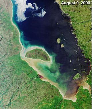
James Bay is a large body of water located on the southern end of Hudson Bay in Canada. It borders the provinces of Quebec and Ontario, and is politically part of Nunavut. Its largest island is Akimiski Island.

<span class="mw-page-title-main">Moosonee</span> Town in Ontario, Canada

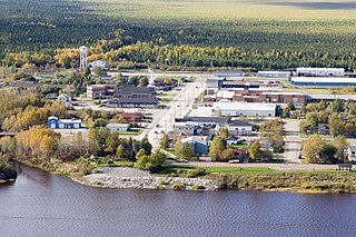
Moosonee is a town in northern Ontario, Canada, on the Moose River approximately 19 km (12 mi) south of James Bay. It is considered to be "the Gateway to the Arctic" and has Ontario's only saltwater port. Nearby on Moose Factory Island is the community of Moose Factory to which it is connected by water taxi in the summer and ice road in the winter.

In Canada, an Indian reserve is defined by the Indian Act as a "tract of land, the legal title to which is vested in His Majesty, that has been set apart by His Majesty for the use and benefit of a band." Reserves are areas set aside for First Nations, one of the major groupings of Indigenous peoples in Canada, after a contract with the Canadian state, and are not to be confused with Indigenous peoples' claims to ancestral lands under Aboriginal title.

<span class="mw-page-title-main">Moose Factory</span> Place in Ontario, Canada

Moose Factory is a community in the Cochrane District, Ontario, Canada. It is located on Moose Factory Island, near the mouth of the Moose River, which is at the southern end of James Bay. It was the first English-speaking settlement in lands now making up Ontario and the second Hudson's Bay Company post to be set up in North America after Fort Rupert. On the mainland, across the Moose River, is the nearby community of Moosonee, which is accessible by water taxi in the summer, ice road in the winter, and chartered helicopter in the off-season.

<span class="mw-page-title-main">Fort Albany First Nation</span> Canadian settlement

Fort Albany First Nation is a Cree First Nation in Cochrane District in Northeastern Ontario, Canada, within the territory covered by Treaty 9. Situated on the southern shore of the Albany River on the west coast of James Bay, Fort Albany First Nation is accessible only by air, water, or by winter road.

Neskantaga First Nation is a remote Oji-Cree First Nation band government in the northern reaches of the Canadian province of Ontario, situated along the shore of Attawapiskat Lake in the District of Kenora.

<span class="mw-page-title-main">Kashechewan First Nation</span> Indian settlement in Ontario, Canada

The Kashechewan First Nation is a Cree First Nation band government located near James Bay in Northern Ontario, Canada. The community is located on the northern shore of the Albany River. Kashechewan First Nation is one of two communities that were established from Old Fort Albany in the 1950s. The other community is Fort Albany First Nation, which is now located on the southern bank of the Albany River. The community is connected to other towns along the shore of James Bay by the seasonal ice road/winter road, linking it to the towns of Attawapiskat, Fort Albany, and Moosonee.

Peawanuck is an isolated Cree community in the Kenora District, Ontario, Canada. It is located near the confluence of the Winisk and Shamattawa rivers, about 35 km from the Winisk River's end in Hudson Bay. Its population is 237.

Kitchenuhmaykoosib Inninuwug, also known as Big Trout Lake First Nation or KI for short, is an Oji-Cree First Nation reserve in Northwestern Ontario and is a part of Treaty 9. The community is about 580 km (360 mi) north of Thunder Bay, Ontario.

<span class="mw-page-title-main">Nishnawbe Aski Nation</span>

Nishnawbe Aski Nation is a political organization representing 51 First Nation communities across Treaty 9 and Treaty 5 areas of Northern Ontario, Canada. Re-organized to its present form in 1981, NAN's original objective was "to represent the social and economic aspirations of our people at all levels of government in Canada and Ontario until such time as real effective action is taken to remedy our problems."

Weenusk First Nation is a Cree First Nation band government in the Canadian province of Ontario. In September, 2007, its total registered population was 516. Weenusk First Nation was an independent member of the Nishnawbe Aski Nation (NAN) but now have joined the Mushkegowuk Council, a regional tribal council, who is also a member of NAN.

<span class="mw-page-title-main">Constance Lake First Nation</span> Oji-Cree First Nations band government

Constance Lake First Nation is an Oji-Cree First Nations band government located on the shores of Constance Lake near Hearst, Cochrane District in northeastern Ontario, Canada. It is directly north of the community of Calstock along a continuation of Ontario Highway 663. Constance Lake First Nation is home to close to 1605 members of Cree and Ojibway with approximately 820 living on reserve. The reserves, Constance Lake 92 and English River 66, total 7,686 acres (3,110 ha) in size.

Cross Lake First Nation is a band of Cree First Nations people in Canada governed under the Indian Act. Its members occupy several reserves within the town of Cross Lake situated on the east shore of Cross Lake in the province of Manitoba. In October 2008, its recorded registered membership was 6,969, of which 4,953 people of this First Nation lived on their reserve. Cross Lake is the principal community of the Pimicikamak indigenous people that made treaty with the British Crown in 1875. Its indigenous language is Woods Cree. Cross Lake was the site of a residential school operated under Canada's assimilation policy. In 2008, Prime Minister Stephen Harper apologized for the damage caused by this policy.

The Victor Mine was the first Canadian diamond mine located in Ontario, and De Beers' second diamond mine in Canada. It is located in the Northern Ontario Ring of Fire, in the James Bay Lowlands 90 kilometres (56 mi) west of Attawapiskat in the remote northern part of the province. In June 2005, the Attawapiskat First Nation voted in favour (85.5%) of ratifying the Impact Benefit Agreement (IBA). Construction of the mine began in February 2006 which created 3200 positions; mining and operations will create around 400 permanent positions. The Victor Mine is an open-pit mine, with a processing plant, workshops, and an airstrip located on site. By 2013–2014 royalties collected from De Beers Victor Mine amounted to $226. At that time De Beers was continuing to pay off its "$1 billion investment to build the mine and from now until it closes, the company expects to pay tens of millions of dollars in royalties." The mine completed mining and processing in 2019 and has moved to a shut-down phase including demolition of infrastructure and rehabilitation of the site.

The Ring of Fire is a vast, mineral-rich region located in the remote James Bay Lowlands of Northern Ontario, Canada. Spanning approximately 5,000 square kilometres (1,900 sq mi), the area is rich in chromite, nickel, copper, platinum group elements, gold, zinc, and other valuable minerals. Discovered in the early 21st century, the Ring of Fire is considered one of the most significant mineral deposits in Canada, with the potential to greatly impact the nation's economy and global mining industry. The development of this region has been a subject of ongoing debate, as stakeholders weigh the economic benefits against environmental concerns and the rights of Indigenous communities in the area. Despite these challenges, the Ring of Fire had remained a focal point for the Canadian mining sector and government, as well as international investors. By July 2023, the federal and provincial governments were no longer in agreement on priorities for federal funding of the Ring of Fire. Georgia Lake lithium project, KGHM's Victoria mine proposal and the Onaping Depth nickel project—which will produce minerals required for the low carbon economy—had become higher priorities, particularly as the Ring of Fire project is situated in a region of "vast, environmentally sensitive...peatlands".

The Mathias Colomb Cree Nation (MCCN) —also known as Mathias Colomb First Nation, Mathias Colomb (Cree) First Nation, and Pukatawagan/Mathias Colomb Cree Nation—is a remote First Nations community in northern Manitoba, located 210 km (130 mi) north of The Pas and 819 km (509 mi) northwest of Winnipeg, Manitoba.

<span class="mw-page-title-main">Shannen's Dream</span> Campaign for First Nations childrens education

Shannen's Dream is a Canadian youth-driven movement advocating for equitable education funding for First Nations children. Education on-reserve is funded by the Government of Canada, while off-reserve education is funded by provincial or territorial governments. Several reports by the Auditor General of Canada, the Parliamentary Budget Officer, and other authorities have indicated an urgent need for improved funding for on-reserve education. Shannen's Dream advocates for the building of safe and comfy schools on reserves, and culturally based education for all First Nations children and youth. The movement was named in honour of Shannen Koostachin, a young activist from the Attawapiskat First Nation and a nominee for the 2008 International Children's Peace Prize

Theresa Spence is a former chief of the Attawapiskat First Nation in Canada. She was a prominent figure in the Attawapiskat housing and infrastructure crisis, Idle No More, and other First Nations issues. Prior to serving as chief, she was the deputy chief of Attawapiskat.

Midnight Shine is a Canadian roots-rock band from Northern Ontario and Manitoba, consisting of lead vocalist/guitarist Adrian Sutherland, bassist/vocalist Stan Louttit, guitarist/vocalist Zach Tomatuk and drummer Charnelle Menow. They have released three studio albums and three music videos and have been actively touring across Canada since 2016.

References

  1. The Canadian Press (2017), The Canadian Press Stylebook (18th ed.), Toronto: The Canadian Press
  2. 1 2 3 "Case Study: Attawapiskat First Nation". Canadian Business Ethics Research Network. Archived from the original on February 28, 2011. Retrieved December 4, 2011.
  3. 1 2 Minkin, Daniel Paul (September 2008). Cultural Preservation and Self-Determination through Land Use Planning: a Framework for the Fort Albany First Nation (PDF) (Master of Urban and Regional Planning). Kingston, Ontario: Queen's University. Archived (PDF) from the original on October 5, 2015. Retrieved December 16, 2015.
  4. "Winter Road Status Updates". James Bay Winter Road. Archived from the original on February 2, 2011. Retrieved August 14, 2011.
  5. Berger, Jonathan; Terry, Thomas (2007). Canoe Atlas of the Little North. Erin, Ontario: Boston Mills Press. pp. 109, 111, 115. ISBN   978-1-55046-496-2. OCLC   78038334. Also OCLC   174417835
  6. 1 2 3 4 General, Zachariah (2012). Akimiski Island, Nunavut, Canada: An Island in Dispute (PDF) (Master of Environmental Studies). Waterloo, Ontario: University of Waterloo.
  7. 1 2 3 4 Norbert W. Witt (1998). "Opening the Healing Path: The Cultural Basis for a Solvent Abusers Treatment Program for the Attawapiskat First Nation" (PhD dissertation). Toronto: Ontario Institute for Studies in Education of the University of Toronto. Retrieved April 17, 2013.
  8. 1 2 3 4 "Archived copy" (PDF). Archived from the original (PDF) on March 8, 2005. Retrieved December 5, 2007.{{cite web}}: CS1 maint: archived copy as title (link)
  9. John J. Honigmann (1953). "Social Organization of the Attawapiskat Cree Indians". Anthropos. 48: 809–816.
  10. 1 2 3 4 Keenebonanoh Keemoshominook Kaeshe Peemishikhik Odaskiwakh We stand on the graves of our ancestors: Native interpretations of Treaty # 9 with Attawapiskat elders (PDF) (MA Canadian Heritage and Development Studies, Trent University). Peterborough, Ontario. 1997.
  11. "Truth and Reconciliation Commission: Former residential school students speak at TRC in Fort Albany". CBC News. Fort Albany, Ontario. January 30, 2013.
  12. For the record : Ontario women graduates in architecture, 1920-1960., University of Toronto. Faculty of Architecture and Landscape Architecture. Ontario Women Graduates., 1986
  13. 1 2 3 4 5 6 7 8 "Community Profile and Timeline of Significant Events". Attawapiskat First Nation Education Authority. Archived from the original on April 26, 2012. Retrieved December 5, 2011.
  14. "CTV.ca | Battle brewing over native school". March 6, 2008. Archived from the original on June 3, 2008. Retrieved November 12, 2008.
  15. "News Release from Catholic Missions in Canada 2006". Sources.com.
  16. "Stories about the Attawapiskat" (PDF). Cupe.on.ca. Retrieved July 27, 2019.
  17. "National Aboriginal Day". Cupe.on.ca. June 20, 2012.
  18. Angus, Charlie (July 28, 2010). "Lives Lived: Shannen Koostachin". The Globe and Mail.
  19. Obomsawin, Alanis (2013). Hi-Ho Mistahey!. National Film Board of Canada.
  20. "TIFF 13: Alanis Obomsawin on Hi-Ho Mistahey!". Playback . September 13, 2013.
  21. "AFN Marks the Ground Breaking for New Attawapiskat Elementary School". Canadian News Wire. June 22, 2012.
  22. 1 2 "Attawapiskat First Nation hospital evacuated because of flooding, sewer backup". Toronto Star . May 1, 2013. Archived from the original on October 29, 2015. Retrieved December 16, 2015.
  23. 1 2 3 "Attawapiskat First Nation declares state of emergency after suicide attempts | CTV News". Ctvnews.ca. April 10, 2016.
  24. 1 2 "Attawapiskat declares state of emergency over spate of suicide attempts - Sudbury - CBC News". Archived from the original on April 11, 2016. Retrieved April 11, 2016.
  25. Thompson, Nicole (April 11, 2016). "11 suicide attempts in one night: Attawapiskat cries for help". The Hamilton Spectator via www.thespec.com.
  26. "Attawapiskat suicide pact of 13 youths, including nine-year-old, broken up by police". Winnipeg Sun . April 12, 2016.
  27. "Attawapiskat". Geographical Names Data Base . Natural Resources Canada.
  28. 1 2 3 Hokimaw-Witt, Jackie (1999). "Attawapiskat First Nation Community Profile: Geographic and Historical Overview" (PDF). Archived from the original (PDF) on October 2, 2011. Retrieved December 4, 2011.
  29. Riley, J.L. 2003. Flora of the Hudson Bay Lowland and Its Postglacial Origins. NRC Research Press, Ottawa, Ontario, Canada. 236 p.
  30. Davis, WJ; Miller, AR (2001). "A Late Triassic Rb-Sr phlogopite isochron age for a kimberlite dyke from the Rankin Inlet area, Nunavut, Current Research 2001-F3" (PDF). Radiogenic age and isotopic studies – Report 14. Geological Survey of Canada . Retrieved August 12, 2009.
  31. "Victor Mine: Factsheet". De Beers Canada. April 17, 2009. Archived from the original on August 31, 2009. Retrieved November 6, 2009.
  32. Ontario Mining Association (August 1, 2008). "Ontario's First Diamond Mine Officially Opened by De Beers Near Attawapiskat". Republic of Mining. Retrieved August 13, 2008.
  33. "Toporama – Topographic Maps – Sheet 43B". Atlas of Canada . Natural Resources Canada. Archived from the original on February 10, 2010. Retrieved August 13, 2009.
  34. "Victor Mine: Factsheet". De Beers Canada. April 17, 2009. Archived from the original on August 31, 2009. Retrieved August 13, 2009.
  35. "Victor Mine: Mining: De Beers Canada". Archived from the original on December 17, 2009. Retrieved November 6, 2009.
  36. 1 2 "Attawapiskat Chief Spence calls for band meeting as diamond mine blockade unfolds". APTN National News. February 5, 2013. Archived from the original on February 8, 2013. Retrieved February 6, 2013.
  37. 1 2 "Attawapiskat band council to meet over diamond mine road blockade". Global News. February 5, 2013. Retrieved April 17, 2013.
  38. "Attawapiskat holding winter blockade against De Beers". February 25, 2009.
  39. Galloway, Gloria (November 30, 2011). "Attawapiskat's woes spark debate about what's wrong on Canada's reserves". The Globe and Mail. Retrieved December 4, 2011.
  40. Ross Pope & Company LLP Chartered Accountants (March 30, 2012). "Attawpiskat Trust Financial Statements Year Ended December 31, 2011" (PDF). Timmins, Ontario. Archived from the original (PDF) on January 23, 2013. Retrieved February 7, 2013.
  41. 1 2 Grech, Ron (June 22, 2011). "High Quality Stones: De Beers expands its exploration of Victor site". The Daily Press. Timmins, Ontario. p. 10. Archived from the original on May 22, 2014. Retrieved February 7, 2013.
  42. 1 2 "The impact of the De Beers diamond mine on Attawapiskat". Morning North. Sudbury, ON: CBC. February 6, 2013.
  43. Linda Goyette (December 10, 2010). "Attawapiskat: The State of First Nations Education in Canada". Canadian Geographic. Retrieved December 3, 2011.
  44. Austen, Ian (April 11, 2016). "Suicides plague Attawapiskat First Nation in Canada". The New York Times .
  45. Norbert Witt; Jackie Hookimaw-Witt PhD (2003). "Pinpinayhaytosown (The Way We Do Things): a Definition of Traditional Ecological Knowledge (TEK) in the Context of Mining Development on Lands of the Attawapiskat First Nation and its Effects on the Design of Research for a TEK Study" (PDF). The Canadian Journal of Native Studies. XXIII (2): 373. Archived from the original (PDF) on April 2, 2015. Retrieved December 4, 2011.
  46. Cummins, Bryan David (1992). Attawapiskat Cree Land Tenure and Use 1901–1989 (Ph.D). Hamilton, Ontario: McMaster University. p. 72. hdl:11375/8611.
  47. 1 2 Berkes, F.; Hughes, A.; George, P.J.; et al. (March 1995). "The Persistence of Aboriginal Land Use: Fish and Wildlife Harvest Areas in the Hudson and James Bay Lowland, Ontario". Arctic . 48 (1): 81–93. doi: 10.14430/arctic1227 . Archived from the original on April 2, 2015. Retrieved February 8, 2013.
  48. 1 2 3 4 5 6 7 Freek, Kerry (March 3, 2012). "Don't Drink the Water: A contaminated water supply and poor plant design risks community health in Attawapiskat". Water Canada the Complete Water Magazine.
  49. "Attawapiskat reserve life: $22 for a 12-pack of pop - Canada - CBC News". Archived from the original on April 16, 2016. Retrieved April 16, 2016.
  50. "Feds aware of Attawapiskat crisis for years". CBC. December 3, 2011. Retrieved December 4, 2011.
  51. "What's next for Attawapiskat?". CBC News. December 3, 2011. Retrieved December 4, 2011.
  52. 1 2 Mackrael, Kim (December 20, 2011). "UN official blasts 'dire' conditions in Attawapiskat". The Globe and Mail. Retrieved August 12, 2022.
  53. "Attawapiskat finances put under 3rd-party control". CBC News. November 30, 2011. Retrieved December 4, 2011.
  54. 1 2 3 4 "Attawapiskat crisis sparks political blame game". CBC News. December 1, 2011. Retrieved December 3, 2011.
  55. "Attawapiskat housing help talks ongoing". CBC News. November 24, 2011. Retrieved December 29, 2012.
  56. Blatchford, Christie (December 27, 2012). "Christie Blatchford: Inevitable puffery and horse manure surrounds hunger strike while real Aboriginal problems forgotten". National Post. Archived from the original on January 29, 2013. Retrieved December 29, 2012.
  57. McCarthy, Shawn; Bradshaw, James (December 30, 2012). "Idle No More protesters block main Toronto-Montreal rail line in support of Chief Spence". The Globe and Mail.
  58. Vowel, Chelsea (December 6, 2011). "Attawapiskat: You Want to Be Shown the Money? Here it Is". Huffington Post. Retrieved January 3, 2013.
  59. Obomsawin, Alanis (2012). The People of the Kattawapiskak River. National Film Board of Canada.
  60. "After the Last River, film about Attawapiskat, in Sudbury tonight". CBC Sudbury, December 2, 2015.
  61. Dunlevy, T'cha (November 9, 2012). "The People of the Kattawapiskak River examines a community on the edge". Montreal Gazette . Postmedia Network Inc. Archived from the original on November 13, 2012. Retrieved November 9, 2012.
  62. "Financial Statements | Attawapiskat First Nation". Attawapiskat.org. Retrieved July 27, 2019.
  63. "Attawapiskat and De Beers". CBC News. November 30, 2011. Retrieved April 17, 2013.
  64. CBC (November 30, 2011). "Attawapiskat finances put under 3rd-party control". Assembly of First Nations. Retrieved December 4, 2011.
  65. Ross, Oakland (December 2, 2011). "Cramped and precarious: Attawapiskat woman living good life compared to most". Toronto Star. Retrieved December 3, 2011.
  66. 1 2 Constitution Act, 1867. Government of Canada. 1867.
  67. "Change to the Department's Name". Aboriginal Affairs and Northern Development Canada. June 2011. Archived from the original on January 14, 2013.
  68. 1 2 3 "Chapter 4: Programs for First Nations on Reserves" (PDF). 2011 June Status Report of the Auditor General of Canada (Report). Office of the Auditor General of Canada. Retrieved January 12, 2013.
  69. "Education is a Right: Fighting for Attawapiskat". Archived from the original on December 11, 2011. Retrieved December 3, 2011.
  70. 1 2 Goyette, Linda (December 10, 2010). "Attawapiskat: The State of First Nations Education in Canada". Canadian Geographic. Retrieved December 3, 2011.
  71. UNESC. 2004-12-08. "Human rights and indigenous issues: Report of the Special Rapporteur on the situation of human rights and fundamental freedoms of indigenous people, Rodolfo Stavenhagen: Mission to Canada." E/CN.4/2005/88/Add.3.
  72. "Archived copy" (PDF). Archived from the original (PDF) on March 10, 2013. Retrieved February 14, 2013.{{cite web}}: CS1 maint: archived copy as title (link)
  73. UNHCHR. 2007-11-01. "United Nations Expert on Adequate Housing Calls for Immediate Attention to Tackle National Housing Crisis in Canada." Geneva.
  74. "More evacuations expected in northern Ontario due to flood fears". Canwest News Service. May 9, 2008. Retrieved December 3, 2011.
  75. 1 2 3 4 5 Deloitte and Touche LLP (September 28, 2012). Audit of the AANDC and Attawapiskat First Nation (AFN) Management Control Framework (Report). Aboriginal Affairs and Northern Development. p. 21. Retrieved January 12, 2013.
  76. 1 2 Lindell, Rebecca (November 29, 2011). "Putting Attawapiskat on the map". Edmonton: Global News. Retrieved December 3, 2011.
  77. Lux, Ryan (November 10, 2011). "Hundreds homeless in Attawapiskat MP says, 'people will die if nothing is done'". The Daily Press. Edmonton. Archived from the original on January 15, 2013. Retrieved December 3, 2011.
  78. Lindell, Rebecca (November 29, 2011). "Putting Attawapiskat on the map". Edmonton: Global News. Retrieved December 3, 2011.
  79. "Canadian Red Cross to support immediate needs in Attawapiskat". Toronto. November 26, 2011. Archived from the original on December 1, 2011. Retrieved December 4, 2011.
  80. "Court file no: T-2037-11, between Attawapiskat First Nations and the Minister of Aboriginal Affairs and Northern Development" (PDF). January 14, 2012. Archived from the original (PDF) on January 31, 2013. Retrieved February 6, 2013.
  81. 1 2 "Attawapiskat renovates temporary trailers for housing: De Beers donated housing units in 2009, but were only to be used as short-term emergency accommodations". CBC. February 5, 2013.
  82. "New Elementary School Project" (PDF). Attawapiskt.org. January 2004. Retrieved July 27, 2019.
  83. "Construction of Elementary School at Attawapiskat First Nation". Archived from the original on February 22, 2014. Retrieved February 10, 2014.
  84. "Attawapiskat declares State of Emergency" (PDF). Attawapiskt.org. Retrieved July 27, 2019.
  85. "Evacuation Update" (PDF). Attawapiskt.org. Retrieved July 27, 2019.
  86. 1 2 ""Reserves, Settlements, Villages", Indian and Northern Affairs Canada". Crown–Indigenous Relations and Northern Affairs Canada . Government of Canada. November 14, 2008. Retrieved May 22, 2013.
  87. "Archived copy" (PDF). Archived from the original (PDF) on December 11, 2011. Retrieved December 5, 2011.{{cite web}}: CS1 maint: archived copy as title (link)
  88. Laura Payton (December 1, 2011). "5 things about Attawapiskat and 3rd party management". CBC. Retrieved April 17, 2013.
  89. Galloway, Gloria (August 1, 2012). "Ottawa's response to Attawapiskat emergency 'unreasonable,' court rules". The Globe and Mail . Retrieved December 31, 2012.
  90. "Provincial-Territorial Organizations". Assembly of First Nations (AFN). Retrieved December 7, 2011.
  91. 1 2 3 "Grand Chief Slams Attacks on Attawapiskat" (PDF). Moose Factory, Ontario: Mushkegowuk Council. January 2013. Archived from the original (PDF) on December 17, 2013. Retrieved February 8, 2013.
  92. Cheadle, Bruce; Levitz, Stephanie (January 7, 2013). "Chief counters release of audit with explicit demands from feds for change". The Canadian Press.
  93. 1 2 "Attawapiskat chief slams audit leak as 'distraction'". CBC News. January 7, 2013.
  94. 1 2 May, Elizabeth (January 9, 2013). "The Attawapiskat audit: Distracting us from a legacy of failure".
  95. "Spence to join Harper meeting with chiefs Jan. 11". CBC News. January 4, 2013. Retrieved January 4, 2013.
  96. "Attawapiskat chief slams audit leak as 'distraction'". CBC News . January 8, 2013. Archived from the original on November 18, 2015. Retrieved December 16, 2015.
  97. "800077.com-威尼斯官方网站vns6010.com-vns8vq.com". Kataquapitinn.com.
  98. "Ontario's far north one step closer to building all-season road". CBC Sudbury, September 17, 2017.
  99. "All-Season Road" Archived November 26, 2018, at the Wayback Machine . Mushkegowuk Council.
  100. "Construction of the James Bay Winter Road underway". January 13, 2021. Retrieved March 15, 2021.
  101. "THE JAMES BAY WINTER ROAD IS OPEN TO HEAVY LOADS UP TO 50 000 KGS" . Retrieved March 14, 2021.
  102. "Hydro One". Hydroone.com.
  103. "History of Five Nations Energy Inc". Fivenations.ca.
  104. "Weeneebayko Health Ahtuskaywin". Archived from the original on November 30, 2011. Retrieved December 1, 2011.
  105. "Weeneebayko Health Ahtuskaywin". Archived from the original on October 29, 2011. Retrieved December 1, 2011.
  106. "Weeneebayko Health Ahtuskaywin". Archived from the original on November 30, 2011. Retrieved December 1, 2011.
  107. "Hello". Archived from the original on November 22, 2011. Retrieved November 30, 2011.
  108. "James Bay Ambulance Service : Pre-Hospital Care on the James Bay Coast". Archived from the original on April 26, 2012. Retrieved July 27, 2019.
  109. [ permanent dead link ]
  110. "Remembering Attawapiskat walker Paul Mattinas - Aboriginal - CBC". Archived from the original on December 25, 2014. Retrieved April 21, 2016.
  111. Galloway, Gloria (December 26, 2012). "As protests swell, Attawapiskat chief stands firm on hunger strike". The Globe and Mail.
  112. "Chief Spence Comments on Court Decision" (PDF). Attawapiskat First Nation. August 1, 2012. Archived from the original (PDF) on January 8, 2013. Retrieved December 26, 2012.
  113. "Shannen's Dream". First Nations Child & Family Caring Society of Canada. 2011. Archived from the original on December 10, 2011. Retrieved December 7, 2011.
  114. "Debates of Sept. 26, 2011". OpenParliament.ca. September 26, 2011. Retrieved December 7, 2011.
  115. "House of Commons". 41st Parliament, 1st Session. 84. February 27, 2012. Retrieved May 22, 2012.
  116. Lindell, Rebecca (November 29, 2011). "Putting Attawapiskat on the map". Global News. Archived from the original on December 3, 2011. Retrieved December 7, 2011.
  117. Goyette, Linda. "Still Waiting in Attawapiskat". Canadian Geographic. Retrieved May 22, 2012.
  118. Koostachin, Shannen (May 23, 2008). "Students of Attawapiskat Plead to Minister Chuck Strahl". YouTube . Archived from the original on December 21, 2021. Retrieved May 22, 2012.
  119. "Attawapiskat Children Fight for a School". Facebook. Retrieved December 7, 2011.
  120. Galloway, Gloria (November 17, 2011). "Teen takes up late cousin's call to improve native schools". The Globe and Mail.
  121. "Book of Memories for Shannen Koostachin". Buffam Leveille Funeral Home Ltd. June 1, 2010. Retrieved December 7, 2011.

Further reading