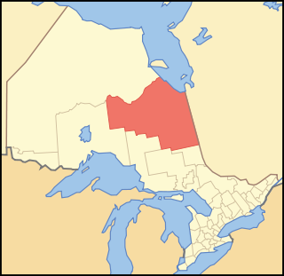
Timiskaming is a district and census division in Northeastern Ontario in the Canadian province of Ontario. The district was created in 1912 from parts of Algoma, Nipissing, and Sudbury districts. In 1921, Cochrane District was created from parts of this district and parts of Thunder Bay District.
Unorganized North Cochrane District is an unorganized area in the District of Cochrane in Northeastern Ontario, Canada. It comprises all parts of the district north of Timmins and Iroquois Falls which are not part of an incorporated municipality.

Unorganized South Nipissing District is an unorganized area in north-central Ontario, in the District of Nipissing. It is almost entirely within and includes most of Algonquin Provincial Park.
Cochrane District is a district and census division in Northeastern Ontario in the Canadian province of Ontario. It was created in 1921 from parts of Timiskaming and Thunder Bay districts.
Unorganized Centre Parry Sound District is an unorganized area in central Ontario, Canada, between Georgian Bay and Lake Nipissing in the District of Parry Sound. It is made up of geographic townships which have no governing bodies and which are not incorporated as municipalities. The territory consists of two non-contiguous areas, with the main part located directly south of the French River and Lake Nipissing, and east of Georgian Bay. Shawanaga Township is a small exclave south of it along Highway 69.

Kenora District is a district and census division in Northwestern Ontario, Canada. The district seat is the City of Kenora.

Nipissing District is a district in Northeastern Ontario in the Canadian province of Ontario. It was created in 1858. The district seat is North Bay.
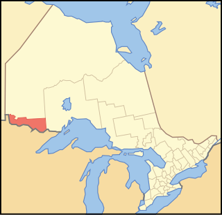
Rainy River District is a district and census division in Northwestern Ontario in the Canadian province of Ontario. It was created in 1885. It is the only division in Ontario that lies completely in the Central Time Zone, except for the township of Atikokan observing Eastern Standard Time for part of the year. Its seat is Fort Frances. It is known for its fishing and its location on the US border opposite International Falls, Minnesota, and Baudette, Minnesota.

Thunder Bay District is a district and census division in Northwestern Ontario in the Canadian province of Ontario. The district seat is Thunder Bay.
Unorganized North Nipissing District is an unorganized area in northeastern Ontario, Canada. It includes the unincorporated areas in northern Nipissing District north of the Mattawa River.

Unorganized Thunder Bay District is an unorganized area in northwestern Ontario, Canada in Thunder Bay District. It comprises all parts of the district that are not part of an incorporated municipality or a First Nations reserve.
Unorganized North Sudbury District is an unorganized area in the Canadian province of Ontario, comprising all portions of the Sudbury District which are not organized into incorporated municipalities. Despite its name, there is no longer an accompanying "South Part", as that subdivision has subsequently been incorporated into municipalities and Statistics Canada has not renamed the North Part.
Machin is a township in the Canadian province of Ontario, located in the Kenora District west of Dryden.

Sioux Narrows-Nestor Falls is a township in the Canadian province of Ontario, located in the Kenora District. It is located on the eastern shores of Lake of the Woods along Ontario Highway 71.

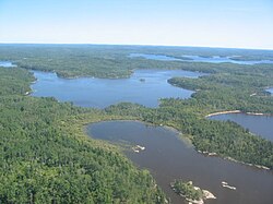
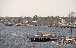
Lake of the Woods is a township in the Canadian province of Ontario, located within the Rainy River District. The township is located on the eponymous Lake of the Woods, consisting of mainland in the south-east part of the lake, the southern shores of Aulneau Peninsula, along with several islands in the lake, including Big Island and Bigsby Island. It fully surrounds the Anishnaabeg of Naongashiing, Big Grassy River 35G, Big Island Mainland 93, and Saug-a-Gaw-Sing 1 First Nation reserves.

Unorganized Rainy River District is an unorganized area in the Rainy River District of Ontario, Canada, comprising all communities in the district which are not part of incorporated municipalities. Quetico Provincial Park is located entirely within this area.

Unorganized West Timiskaming District is an unorganized area in the Canadian province of Ontario, comprising almost all portions of the Timiskaming District which are not organized into incorporated municipalities.

Unorganized East Timiskaming District is an unorganized area in the Canadian province of Ontario, comprising the unincorporated portions of the Timiskaming District lying east of the municipal boundaries of Kirkland Lake and north of the municipal boundaries of Gauthier, Larder Lake and McGarry.
Unorganized South East Algoma District is an unorganized area in the Canadian province of Ontario, comprising a small unincorporated portion in the southeasternmost corner of the Algoma District. It comprises a small strip of land which lies between the territory of the Sagamok First Nation and the Algoma District's boundary with the Sudbury District, as well as several small islands within the North Channel of Lake Huron, such as Eagle, Fréchette, Fox, Hotham, Middleton, North and South Benjamin Islands.

Unorganized South East Cochrane District is an unorganized area in the Canadian province of Ontario, encompassing the small portion of the Cochrane District, immediately surrounding Highway 11 at the division's southern boundary with the Timiskaming District, which is not part of the municipality of Black River-Matheson which surrounds it. It consists of the southern half of the geographic township of Benoit and is the southernmost limit of the Great Clay Belt of northern Ontario.