The Albany River is a river in Northern Ontario, Canada, which flows northeast from Lake St. Joseph in Northwestern Ontario and empties into James Bay. It is 982 kilometres (610 mi) long to the head of the Cat River, tying it with the Severn River for the title of longest river entirely in Ontario. Major tributaries include the Kenogami River and Ogoki River.

The Flying Dust First Nation is a Cree First Nation band government located adjacent to the city of Meadow Lake in Saskatchewan, Canada. Highway 55 goes through the band's reserve community.

The Oji-Cree are a First Nation in the Canadian provinces of Ontario and Manitoba, residing in a narrow band extending from the Missinaibi River region in Northeastern Ontario at the east to Lake Winnipeg at the west.
Mishkeegogamang First Nation is an Ojibway band government in the Canadian province of Ontario. Until 1993, the band was called the Osnaburgh First Nation, with various settlements at times being called New Osnaburgh, Osnaburgh House, or Osnaburgh.
Cat Lake First Nation is an Ojibway First Nation reserve approximately 180 kilometres northwest of Sioux Lookout in northwestern Ontario, Canada, located on the central north shore of Cat Lake. As of 2021, their total registered population was 651 people.
Kitchenuhmaykoosib Inninuwug, also known as Big Trout Lake First Nation or KI for short, is an Oji-Cree First Nation reserve in Northwestern Ontario and is a part of Treaty 9. The community is about 580 km (360 mi) north of Thunder Bay, Ontario.
North Spirit Lake First Nation is a small Oji-Cree First Nation reserve in Northern Ontario, located north of Red Lake, Ontario. It is connected to Sandy Lake First Nation, and Deer Lake First Nation by winter/ice roads. It is part of the Keewaytinook Okimakanak Council and the Nishnawbe Aski Nation.
Canoe Lake 165 is an Indian reserve of the Canoe Lake Cree First Nation in the boreal forest of northern Saskatchewan, Canada. Its location is on Canoe Lake approximately thirty miles west of Beauval, within the ancient hunting grounds of the Woodland Cree. In the 2016 Canadian Census, it recorded a population of 912 living in 250 of its 273 total private dwellings. In the same year, its Community Well-Being index was calculated at 53 of 100, compared to 58.4 for the average First Nations community and 77.5 for the average non-Indigenous community. The reserve includes the settlement of Canoe Narrows. The name of the reserve and the settlement in Cree is nêhiyaw-wapâsihk ᓀᐦᐃᔭᐤ ᐘᐹᓯᕽ.
Fort McMurray First Nation is a Cree and Chipewyan band government located near Fort McMurray, Alberta. It is a member of the Athabasca Tribal Council and a Treaty 8 nation. The Athabasca Tribal Council represents 5 First Nation bands in northeast Alberta. Fort McMurray First Nation is governed by a Chief and two councillors.
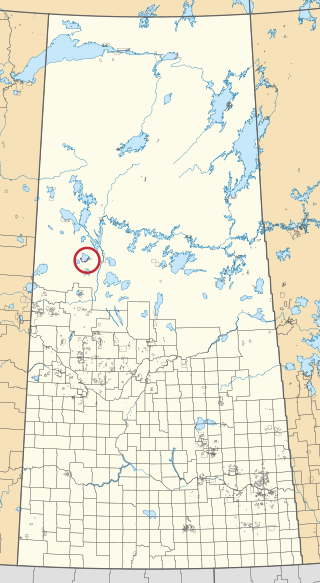
Osnaburgh 63B is a First Nations reserve in Kenora District, Ontario. It is one of the reserves of the Mishkeegogamang First Nation, alongside Osnaburgh 63A.
Sachigo Lake 1 is a First Nations reserve in northwestern Ontario. It is the main reserve of the Sachigo Lake First Nation.
Kingfisher Lake 1 is a First Nations reserve in Kenora District, Ontario. It is one of the reserves of the Kingfisher First Nation.

Census Division No. 16 is a census division located within the Parklands Region of the province of Manitoba, Canada. Unlike in some other provinces, census divisions do not reflect the organization of local government in Manitoba. These areas exist solely for the purposes of statistical analysis and presentation; they have no government of their own.
The Tootinaowaziibeeng First Nation is an Anishinabe band in Manitoba. They are located on reserve land at IR Valley River 63A. They number about 600 with a similar number located in various locations away from the reserve. The location of their land is east of Roblin and west of Grandview. The band members are associated with the West Region Tribal Council.
The Tootinaowaziibeeng Treaty Reserve is a First Nation located 35 km east of Roblin, Manitoba, 74 km west of Dauphin, Manitoba, and approximately 5 km north of PTH #5. Tootinaowaziibeeng is a Treaty 4 First Nation.
The Montreal Lake Cree Nation is a Woodland Cree First Nation in northern Saskatchewan. The administrative centre of the Montreal Lake Cree Nation is located in the community of Montreal Lake.
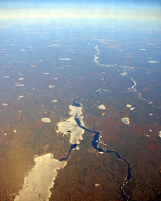
The Doghole River is a river in the Unorganized Part of Kenora District in Northwestern Ontario, Canada. The river is part of the James Bay drainage basin. It flows from Doghole Lake, where the outlet is part of the Mishkeegogamang First Nation Osnaburgh Indian Reserve No. 63B, to the northeast shore of Lake St. Joseph; oddly, the mouth is not on Doghole Bay, adjacent to the east. Lake St. Joseph is the source of the Albany River, which flows to James Bay.
Doghole Lake is a lake in the Unorganized Part of Kenora District in Northwestern Ontario, Canada. The lake is part of the James Bay drainage basin, and is the source of the Doghole River, which flows to Lake St. Joseph, and then via the Albany River to James Bay. The majority of the lake is within the Mishkeegogamang First Nation Osnaburgh Indian Reserve No. 63B, whose main community is on the lake's eastern shore, adjacent to Ontario Highway 599.
Shoal Lake 39A is a First Nations reserve straddling the border of Manitoba and Ontario on the shores of Shoal Lake. It is one of the reserves of the Iskatewizaagegan 39 Independent First Nation.
Shoal Lake 40 is a First Nations reserve straddling the border of Manitoba and Ontario on the shores of Shoal Lake. It is one of the reserves of the Shoal Lake 40 First Nation.

