
The Kenogami River is a river in the James Bay drainage basin in Thunder Bay and Cochrane districts in Northern Ontario, Canada, which flows north from Long Lake near Longlac to empty into the Albany River. The river is 320 kilometres (199 mi) in length and its name means "long water" in the Cree language. A portion of the river's headwaters have been diverted into the Lake Superior drainage basin.
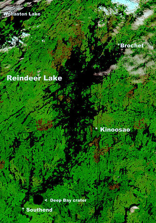
Reindeer Lake is a lake in Western Canada located on the border between north-eastern Saskatchewan and north-western Manitoba, with the majority in Saskatchewan. The name of the lake appears to be a translation of the Algonquian name. It is the 24th largest lake in the world by area, as well as being the second-largest lake in Saskatchewan and the ninth largest in Canada. Eight percent of the lake lies in Manitoba while 92% of the lake is in Saskatchewan.
Nipigon is a township in Thunder Bay District, Northwestern Ontario, Canada, located along the west side of the Nipigon River and south of the small Helen Lake running between Lake Nipigon and Lake Superior. Lake Nipigon is located approximately 25 kilometres (16 mi) north of Nipigon. Located at latitude 49.0125° N, Nipigon is the northernmost community on the Great Lakes.

Little Grand Rapids is a community in east central Manitoba, Canada, near the Ontario border. It is located approximately 280 kilometers or 173 miles north-northeast from Winnipeg, Manitoba.

Biscotasing, often referred to as simply Bisco, is a community in the Unorganized North Part of Sudbury District in Northeastern Ontario, Canada. It was founded on the shores of Lake Biscotasi on the Spanish River in 1884 by Canadian Pacific Railway as a railway construction town, and the first divisional point west of Sudbury. The rails of westward track laying gangs reached this area in October 1884.
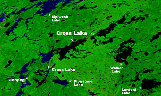
Cross Lake is a community in the Northern Region of the Canadian province of Manitoba, situated on the shores of the Nelson River where the river enters the namesake Cross Lake. An all-weather road, PR 374, connects the communities to PR 373 via the Kichi Sipi Bridge.

Secondary Highway 599, commonly referred to as Highway 599, is a provincially maintained secondary highway in the Canadian province of Ontario. The 291.0 km (180.8 mi) route connects Highway 17 near Ignace with the remote northern community of Pickle Lake; its terminus at Pickle Lake marks the northernmost point on the provincial highway system. Highway 599 was first assigned in 1956 between Savant Lake and Pickle Lake, although it did not connect with the rest of the provincial highway system at the time. Construction to link it with Highway 17 in Ignace took place between 1958 and 1966. The northern end of Highway 599 is one of two possible starting points for a road to the Ring of Fire mineral deposits, the other being Highway 584 in Nakina.
Fort Ellice was a Hudson's Bay Company trading post that operated from 1794 to 1892. It was first established in February 1794 by John Sutherland on the Qu'Appelle River about 20 kilometres (12 mi) upstream from its mouth at the Assiniboine River, and known as the Qu'Appelle River Post until it was destroyed by the North West Company in 1816.

Batchawana Bay is a small bay in Algoma District in Northeastern Ontario, Canada. It is on the eastern shore of Lake Superior, approximately 50 kilometres (31 mi) north of Sault Ste. Marie.
The Berens River is a river in the provinces of Manitoba and Ontario, Canada. It flows west from an unnamed lake in Kenora District, Ontario, and discharges its waters into Lake Winnipeg near the community and First Nation of Berens River, Manitoba. The river has a number of lakes along its course, and many rapids.
Dinorwic is an unincorporated settlement in northwestern Ontario, Canada. It is situated at the northern head of the lake with the same name, along the Canadian Pacific Railway and Highway 17 at the junction of Highway 72.

Hudson is an unincorporated place and community in the municipality of Sioux Lookout, Kenora District in northwestern Ontario, Canada. It is located on Lost Lake on the English River in the Nelson River drainage basin.

Longlac is a community in the municipality of Greenstone, in northwestern Ontario, Canada. It is located along Highway 11 and the Canadian National Railway, on the namesake Longlac Bay at the northern end of Long Lake.

Gull Bay First Nation or Kiashke Zaaging Anishinaabek is an Anishinaabe (Ojibway) First Nation band government located in Thunder Bay District in northwestern Ontario, Canada. It is approximately 175 kilometres (109 mi) north of Thunder Bay, Ontario on Highway 527 on the western shore of Lake Nipigon. As of May 2010, the First Nation had a registered population of 1,149 people, including an on-Reserve population of 328.

Kaipokok Bay is a bay in Labrador, Canada, that extends for 56 kilometres (35 mi) inland from the northern Atlantic Ocean. The bay is sparsely populated, with Postville being the only permanent settlement. Several trading posts existed along the bay until the 1950s, including the former settlement of Kaipokok, where the Hudson's Bay Company (HBC) operated a trading post from 1837 to 1880.
Allanwater Bridge railway station is located just north of Kawaweogama Lake in the Canadian province of Ontario, directly west of where the railway line crosses the river Allan Water over a truss bridge. This station is served by Via Rail. Transcontinental Canadian trains stop here under Via Rail's Special Stop Request program.

Eagle Lake is a lake in Kenora District, Ontario, Canada, west of the City of Dryden. The communities of Vermilion Bay and Eagle Lake First Nation are located on the lake's north shore.
The Kabinakagami River is a river in Cochrane and Algoma Districts in northeastern Ontario, Canada. It is part of the James Bay drainage basin and is a right tributary of the Kenogami River.
Fowler is a railway point and unincorporated place in Unorganized Kenora District in northwestern Ontario, Canada, just west of the border with Thunder Bay District.

Sipiwesk Lake is a large lake in the province of Manitoba in Canada north of Lake Winnipeg. The lake is a part of the Nelson River watershed and is located north of Cross Lake. The lake is about 78 km long.

