
Thunder Bay District is a district and census division in Northwestern Ontario in the Canadian province of Ontario. The district seat is Thunder Bay.

Lake Nipigon is part of the Great Lake drainage basin. It is the largest lake entirely within the boundaries of the Canadian province of Ontario.
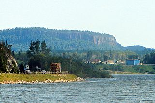
The Red Rock Indian Band is an Ojibwe First Nation band government in Northwestern Ontario, Canada. Their territory is located on the Red Rock 53 and Lake Helen 53A Indian reserves in Ontario. As of March 2017, they had a total registered population of 1,837 people. The Nation is led by Chief Marcus Hardy. The council is an independent member of Anishnabek Nation, a First Nations political organization. The First Nation is also a member of Waaskiinaysay Ziibi Inc., an economic development corporation made up of five Lake Nipigon First Nations.
Mistawasis Nêhiyawak is a Cree First Nation band government in Leask, Saskatchewan, Canada. Their settlement is roughly sixty-eight kilometres west of Prince Albert. The Nation has one reserve with an area of approximately 125.44 square kilometres.

Division No. 15 is one of eighteen census divisions in the province of Saskatchewan, Canada, as defined by Statistics Canada. It is located in the north-central part of the province. The most populous community in this division is Prince Albert.

The Red Pheasant Cree Nation is a Plains Cree First Nations band government in the Canadian province of Saskatchewan. The band's sole reserve, Red Pheasant 108, is 33 km (21 mi) south of North Battleford.

Saddle Lake 125 is an Indian reserve of the Saddle Lake Cree Nation in Alberta, located between Smoky Lake County and the County of St. Paul No. 19. It is 24 kilometres west of St. Paul.

Makaoo 120 is an Indian reserve of the Onion Lake Cree Nation in Alberta and Saskatchewan, located between the County of Vermilion River and the Rural Municipality of Frenchman Butte No. 501. It is 42 kilometres north of Lloydminster. In the 2016 Canadian Census, it recorded a population of 726 living in 165 of its 179 total private dwellings.

Alexis 133 is an Indian reserve of the Alexis Nakota Sioux Nation in Alberta, located within Lac Ste. Anne County. It is 70 kilometres northwest of Edmonton. In the 2016 Canadian Census, it recorded a population of 755 living in 173 of its 209 total private dwellings.
Lake Helen 53A is a First Nations reserve in Thunder Bay District, Ontario, Canada. It is one of two reserves for the Red Rock Indian Band.
The Shoal Lake Cree Nation is a Swampy Cree First Nations band government in Saskatchewan, Canada located 98 kilometres (61 mi) east of Nipawin. The Cree First Nation is on the Carrot River and can be accessed by Highway 55. Nearby to the west is the Red Earth First Nation.

Red Earth First Nation is a Swampy Cree First Nations band government in Saskatchewan, Canada. It is located 225 kilometres (140 mi) northeast of Prince Albert. The main settlement of Red Earth is located on the Carrot River and accessed by Highway 55. Nearby to the east is the Shoal Lake First Nation.

Unipouheos 121 is an Indian reserve of the Frog Lake First Nation in Alberta, located within the Municipal District of Bonnyville No. 87 and the County of St. Paul No. 19. It is 32 kilometres southeast of Bonnyville. In the 2016 Canadian Census, it recorded a population of 909 living in 205 of its 232 total private dwellings.

Carrot River 29A is an Indian reserve of the Red Earth Cree Nation in Saskatchewan. It is 48 miles east of Nipawin. In the 2016 Canadian Census, it recorded a population of 829 living in 127 of its 127 total private dwellings. In the same year, its Community Well-Being index was calculated at 40 of 100, compared to 58.4 for the average First Nations community and 77.5 for the average non-Indigenous community.

The Chief Joseph Custer Reserve is an Indian reserve of the Peter Ballantyne Cree Nation in Saskatchewan. It is located in the city of Prince Albert, making it an urban reserve.

Little Red River 106C is an Indian reserve of the Lac La Ronge Indian Band in Saskatchewan. It is 34 kilometres north of Prince Albert. In the 2016 Canadian Census, it recorded a population of 354 living in 88 of its 98 total private dwellings. In the same year, its Community Well-Being index was calculated at 48 of 100, compared to 58.4 for the average First Nations community and 77.5 for the average non-Indigenous community.

Little Red River 106D is an Indian reserve of the Lac La Ronge Indian Band in Saskatchewan. It is 25 miles north of Prince Albert, and in Township 53, Range 1, west of the Third Meridian. In the 2016 Canadian Census, it recorded a population of 5 living in 1 of its 3 total private dwellings.

Montreal Lake 106B is an Indian reserve of the Montreal Lake Cree Nation in Saskatchewan. It is adjacent to Little Red River 106C and 39 kilometres (24 mi) north of Prince Albert. In the 2016 Canadian Census, it recorded a population of 442 living in 113 of its 118 total private dwellings. In the same year, its Community Well-Being index was calculated at 47 of 100, compared to 58.4 for the average First Nations community and 77.5 for the average non-Indigenous community.

Red Earth 29 is an Indian reserve of the Red Earth Cree Nation in Saskatchewan. It is 75 kilometres east of Nipawin. In the 2016 Canadian Census, it recorded a population of 334 living in 61 of its 82 total private dwellings. In the same year, its Community Well-Being index was calculated at 40 of 100, compared to 58.4 for the average First Nations community and 77.5 for the average non-Indigenous community.
Red Rock Ecological Reserve is an ecological reserve located adjacent to the Tom Lamb Wildlife Management Area, Manitoba, Canada. It was established in 1979 under the Manitoba Crown Lands Act. It is 5.02 square kilometres (1.94 sq mi) in size.

