
The Oji-Cree are a First Nation in the Canadian provinces of Ontario and Manitoba, residing in a narrow band extending from the Missinaibi River region in Northeastern Ontario at the east to Lake Winnipeg at the west.
Eabametoong, also known as Fort Hope or Eabamet Lake by Canada Post, is an Ojibwe First Nations band government in Kenora District, Ontario, Canada. Located on the shore of Eabamet Lake in the Albany River system, the community is located approximately 300 km (190 mi) northeast of Thunder Bay and is accessible only by airplane via Fort Hope Airport or water, or by winter/ice roads, which connect the community to the Northern Ontario Resource Trail. The Eabametoong First Nation Reserve is completely surrounded by territory of the Unorganized Kenora District.

Secondary Highway 599, commonly referred to as Highway 599, is a provincially maintained secondary highway in the Canadian province of Ontario. The 291.0 km (180.8 mi) route connects Highway 17 near Ignace with the remote northern community of Pickle Lake; its terminus at Pickle Lake marks the northernmost point on the provincial highway system. Highway 599 was first assigned in 1956 between Savant Lake and Pickle Lake, although it did not connect with the rest of the provincial highway system at the time. Construction to link it with Highway 17 in Ignace took place between 1958 and 1966. The northern end of Highway 599 is one of two possible starting points for a road to the Ring of Fire mineral deposits, the other being Highway 584 in Nakina.
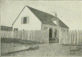
Osnaburgh 63A is a First Nations reserve on Lake St. Joseph in Thunder Bay District, Ontario. It is one of the reserves of the Mishkeegogamang First Nation, alongside Osnaburgh 63B.
Wapekeka First Nation is a First Nation band government in the Canadian province of Ontario. An Oji-Cree community in the Kenora District, the community is located approximately 450 kilometres northeast of Sioux Lookout. In January, 2008, the total registered population was 375, of which the on-reserve population was 355.
Cat Lake First Nation is an Ojibway First Nation reserve approximately 180 kilometres northwest of Sioux Lookout in northwestern Ontario, Canada, located on the central north shore of Cat Lake. As of 2021, their total registered population was 651 people.
Kitchenuhmaykoosib Inninuwug, also known as Big Trout Lake First Nation or KI for short, is an Oji-Cree First Nation reserve in Northwestern Ontario and is a part of Treaty 9. The community is about 580 km (360 mi) north of Thunder Bay, Ontario.
Webequie First Nation is located on the northern peninsula of Eastwood Island on Winisk Lake, 540 km (336 mi) north of Thunder Bay in Ontario, Canada. Webequie is a fly-in community with no summer road access. The primary way into the community is by air to Webequie Airport or winter road, which connects to the Northern Ontario Resource Trail. The First Nation have the 34,279 ha Webequie Indian reserve. The Webequie or Webiqui Indian Settlement also have reserve status. Webequie First Nation is a member of the Matawa First Nations, a Regional Chiefs' Council and a member of the Nishnawbe Aski Nation.
Poplar Hill First Nation is an Anishinaabe (Ojibway) First Nation band government, approximately 120 km north of Red Lake near the Ontario-Manitoba border. The First Nation is accessible by air and winter road. In May 2016, the First Nation had a registered population of 473 people.
Nibinamik First Nation, also known as Summer Beaver Band, is a small Oji-Cree First Nation reserve in Northern Ontario, located on the Summer Beaver Settlement that is connected to the rest of the province by its airport, and a winter/ice road that leads to the Northern Ontario Resource Trail.

Bearskin Lake First Nation is an Oji-Cree First Nation reserve in Kenora District, Ontario, Canada, located 425 kilometres (264 mi) north of Sioux Lookout. Bearskin First Nation's total registered population as of March 2014 was 900, of which their on-reserve population was 461.

Nishnawbe Aski Nation is a political organization representing 51 First Nation communities across Treaty 9 and Treaty 5 areas of Northern Ontario, Canada. Re-organized to its present form in 1981, NAN's original objective was "to represent the social and economic aspirations of our people at all levels of government in Canada and Ontario until such time as real effective action is taken to remedy our problems."
Marten Falls First Nation is an Anishinaabe First Nation reserve located in northern Ontario. The First Nation occupies communities on both sides of the Albany River in Northern Ontario, including Ogoki Post in the Cochrane District and Marten Falls in the Kenora District. As of December 2013, the First Nation had a total registered population of 728 people, of which their on-reserve population was 328 people.
Osnaburgh 63B is a First Nations reserve in Kenora District, Ontario. It is one of the reserves of the Mishkeegogamang First Nation, alongside Osnaburgh 63A.
Chapleau Ojibway First Nation is an Ojibwa First Nation located near Chapleau Township, Sudbury District, Ontario, Canada. The First Nation have reserved for themselves the 67 ha Chapleau 61A Indian Reserve, 64.7 ha Chapleau 74 Indian Reserve and the 799.3 ha Chapleau 74A Indian Reserve. In September, 2007, their total registered population 39, of which their on-reserve population was 30.
The Ojibway Nation of Saugeen is an Ojibwa First Nation in the Canadian province of Ontario. The Nation is located in the Thunder Bay District, approximately 20 kilometres northwest of Savant Lake. In December, 2007, its total registered population was 206, of which the on-reserve population was 72. The community maintains strong ties with Mishkeegogamang First Nation
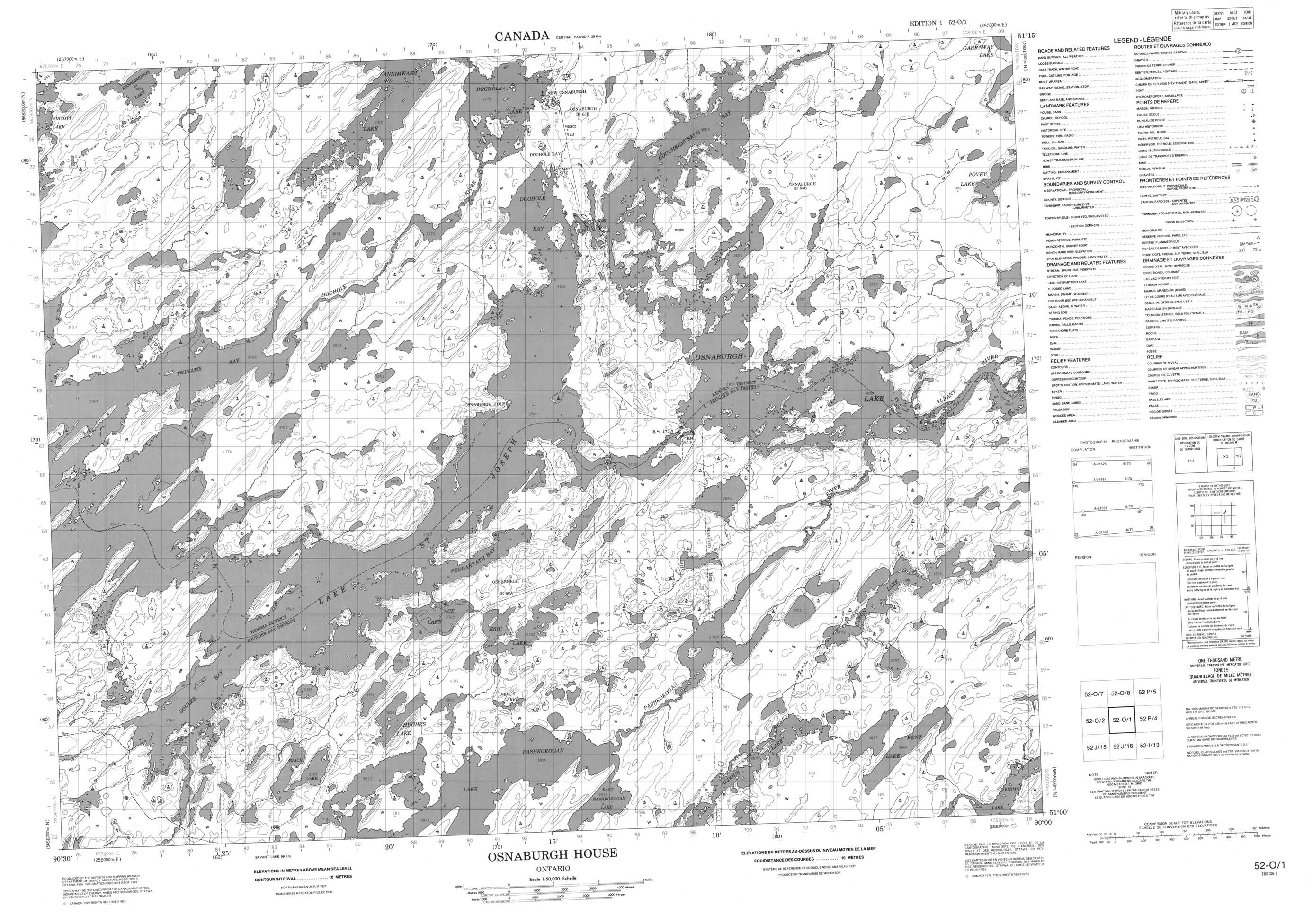
Lake St. Joseph is a large lake in Kenora District and Thunder Bay District in Northwestern Ontario, Canada. It is in the James Bay drainage basin and is the source of the Albany River. The east end of the lake can be reached using Ontario Highway 599 from the town of Ignace, 260 kilometres (160 mi) to the south on Ontario Highway 17. The nearest town is Pickle Lake, 30 kilometres (19 mi) north along Highway 599.
Sachigo Lake First Nation is an Oji-Cree First Nation band government in Unorganized Kenora District in Northwestern Ontario, Canada. It is located on Sachigo Lake, part of the Sachigo River system and Hudson Bay drainage basin, approximately 425 kilometres (264 mi) north of the town of Sioux Lookout. As of September 2011, the First Nation had a registered population of 814 people, of which the on-reserve population was 443.
Ginoogaming First Nation is a small Anishinaabe (Ojibway) First Nation reserve located in Northern Ontario, located approximately 40 km east of Geraldton, Ontario, Canada, on the northern shore of Long Lake, immediately south of Long Lake 58 First Nation and the community of Longlac, Ontario. As of September, 2006, their total registered population was 773 people, of which their on-Reserve population was 168.
Doghole Lake is a lake in the Unorganized Part of Kenora District in Northwestern Ontario, Canada. The lake is part of the James Bay drainage basin, and is the source of the Doghole River, which flows to Lake St. Joseph, and then via the Albany River to James Bay. The majority of the lake is within the Mishkeegogamang First Nation Osnaburgh Indian Reserve No. 63B, whose main community is on the lake's eastern shore, adjacent to Ontario Highway 599.


