Rossport, Ontario

Last updated
Rossport
Unincorporated community
Rossport ON.JPG
Canada Ontario location map 2.svg
Red pog.svg
Rossport
Location of Rossport in Ontario
Coordinates: 48°50′09″N87°31′14″W / 48.83583°N 87.52056°W / 48.83583; -87.52056 Coordinates: 48°50′09″N87°31′14″W / 48.83583°N 87.52056°W / 48.83583; -87.52056 [1]
Country Canada
Province Ontario
District Thunder Bay
Area
[2]
  Total1.12 km2 (0.43 sq mi)
Elevation
[3]
192 m (630 ft)
Population
 (2011) [2]
  Total65
  Density58/km2 (150/sq mi)
Time zone UTC-5 (Eastern Time Zone)
  Summer (DST) UTC-4 (Eastern Time Zone)
Postal code
P0T 2R0
Area code(s) 807

Rossport is a dispersed rural community and unincorporated place in the Unorganized part of Thunder Bay District in northwestern Ontario, Canada. [1] It is on the north shore of Lake Superior in geographic Lahontan Township, [4] and is on Ontario Highway 17. Rossport is a designated place served by a local services board, [5] and has a population of 65. [2]

Contents

History

Rossport is named after John Ross (c1820-1898), construction manager for the north shore of Lake Superior route of the Canadian Pacific Railway from August 1882 to June 1885. His construction headquarters during that time period were in Port Arthur, Ontario and at Rossport, then known as McKay's Harbour. [6]

McKay's Harbour was named after Alexander McKay who operated a small fur trading post at Pays Plat and his son, Charles McKay, who was a lighthouse keeper at nearby Battle Island from 1878-1913.

After the end of CPR construction in 1885, Rossport became an important commercial fishing centre. Bowman Street is named after John Bowman (1858–1950) who operated a fishing company there. [7]

Tiny Rossport garnered a wide reputation for being a source of prime fish. An article in the Dominion Illustrated from October 1888, speaks of how dealers from Eastern Canada had travelled to Rossport and other North Shore communities in order to contract for Lake Superior’s fine freshwater fish. [8] Another article from November 1888 talks of a trial shipment of ten barrels of fish from Rossport being sent to Belfast Ireland, where it was quickly sold. [9]

In 1901, Rossport joined other North Shore port communities in becoming a regular stop for steamships belonging to Francis Clergue. The vessels operated between Sault Ste Marie and Port Arthur. [10]

In 1907, tenders were called by the Dominion Public Works Department for the construction of a wharf at Rossport. [11]

Most interesting is how a small local competition in 1937 morphed into an international event. [12] There was a time when the Rossport Fish Derby was a staple on every sports fisherman's calendar. An August 1952 article in the Toronto Star describes over 4000 people attending that year’s self-proclaimed “greatest amateur fishing event in North America”. [13] Cars, tents and people would be visible along the highway for a distance as participants arrived and staked out a piece of land to camp on for the one-day event. [14] The arrival to the Lake of a non-native species, the Lamprey eel, caused devastation to the Lake trout population and, over time, brought about the downfall to the days of the derby.

In 1911 the luxury steam yacht Gunilda, owned by William L. Harkness, foundered on the McGarvey Shoal and sank 8 kilometres from Rossport. The actual date of the sinking varies from August 11 to August 29 to August 31st depending upon the article. A Toronto Daily Star news item contained in the Friday, September 1, 1911 edition states that the vessel ran aground on Wednesday, which would be August 30, and then refers to the sinking as occurring "yesterday" or August 31, 1911. This timeframe could reflect accuracy as after the vessel ran aground on the shoal and stabilized, a small boat was sent to Rossport where arrangements were made for the dispatch of a rescue tug from Port Arthur. It would take time for that tug to travel to Rossport. Therefore there would be a difference in the time between when the Gunilda ran aground and when it was actually pulled off the shoal only to sink. [15] [16] [17] [18]

Painters from the Group of Seven (artists) visited Rossport and the surrounding area several times in the 1920s. [19] In 2018, a plaque was installed in Wardrop Park celebrating their visits and Lawren Harris' painting "Rossport, Lake Superior - 1921" as part of the Moments of Algoma tourism initiative. [20]

On October 3, 1933, Rossport's waterfront suffered great damage as a result of an unusual tidal phenomenon with Lake Superior. [21] [22]

Local government

Rossport is managed by a local services board. Rossport has a water treatment plant which serves 45 households. The hamlet falls within the provincial and federal ridings of Thunder Bay-Superior North.

Recreation and Environment

The Lake Superior National Marine Conservation Area, which includes the waters off Rossport, was created by Parks Canada on June 24, 2015. [23]

In 2009, an eight-island archipelago just off Rossport, including Wilson Island, was purchased from private owners and was to become a Canadian federal natural area under a joint deal backed by the Nature Conservancy of Canada, the Government of Canada and the Government of Ontario, and supported by the Pays Plat First Nation. [24] [25]

The Voyageur Hiking Trail passes through the town.

Demographics

Rossport had a population of 66 in the Canada 2006 Census, a decrease of 41.1% since 2001, [26] but only dropped to 65 persons in the 2011 census. [2]

Canada census – Rossport, Ontario community profile
2011
Population65 (-1.5% from 2006)
Land area1.12 km2 (0.43 sq mi)
Population density58.2/km2 (151/sq mi)
Median age54.1 (M: 54.5, F: 52.5)
Total private dwellings69
Median household income
References: 2011 [27] earlier [28] [29]

Related Research Articles

Lake Huron One of the Great Lakes of North America

Lake Huron is one of the five Great Lakes of North America. Hydrologically, it comprises the easterly portion of Lake Michigan–Huron, having the same surface elevation as Lake Michigan, to which it is connected by the 5-mile-wide (8.0 km), 20-fathom-deep Straits of Mackinac. It is shared on the north and east by the Canadian province of Ontario and on the south and west by the U.S. state of Michigan. The name of the lake is derived from early French explorers who named it for the Huron people inhabiting the region.

Northern Ontario Primary Region in Ontario, Canada

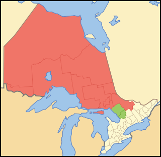
Northern Ontario is a primary geographic and quasi-administrative region of the Canadian province of Ontario, the other primary region being Southern Ontario. Most of the core geographic region is located on part of the Superior Geological Province of the Canadian Shield, a vast rocky plateau located mainly north of Lake Huron, the French River, Lake Nipissing, and the Mattawa River. The statistical region extends south of the Mattawa River to include all of the District of Nipissing. The southern section of this district lies on part of the Grenville Geological Province of the Shield which occupies the transitional area between Northern and Southern Ontario. The extended federal and provincial quasi-administrative regions of Northern Ontario have their own boundaries even further south in the transitional area that vary according to their respective government policies and requirements. Ontario government departments and agencies such as the Growth Plan for Northern Ontario and the Northern Ontario Heritage Fund Corporation define Northern Ontario as all areas north of, and including, the districts of Parry Sound and Nipissing for political purposes, whilst the federal government, but not the provincial, also includes the district of Muskoka.

Thunder Bay City in Ontario, Canada

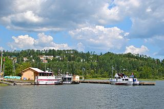
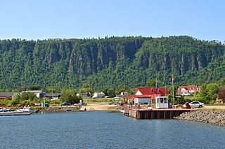
Thunder Bay is a city in and the seat of Thunder Bay District, Ontario, Canada. It is the most populous municipality in Northwestern Ontario and the second most populous municipality in Northern Ontario; its population is 108,843 according to the 2021 Canadian Census. Located on Lake Superior, the census metropolitan area of Thunder Bay has a population of 123,258 and consists of the city of Thunder Bay, the municipalities of Oliver Paipoonge and Neebing, the townships of Shuniah, Conmee, O'Connor, and Gillies, and the Fort William First Nation.

Thunder Bay District District in Ontario, Canada

Thunder Bay District is a district and census division in Northwestern Ontario in the Canadian province of Ontario. The district seat is Thunder Bay.

Canadian Northern Railway Former railway company

The Canadian Northern Railway (CNoR) was a historic Canadian transcontinental railway. At its 1923 merger into the Canadian National Railway, the CNoR owned a main line between Quebec City and Vancouver via Ottawa, Winnipeg, and Edmonton.

Terrace Bay Township in Ontario, Canada

Terrace Bay is a township in Thunder Bay District in northern Ontario, Canada, located on the north shore of Lake Superior east of Thunder Bay along Highway 17. The name originates from a series of lake terraces formed as the water level in Lake Superior lowered following the latest ice age.

Nipigon Township in Ontario, Canada

Nipigon is a township in Thunder Bay District, Northwestern Ontario, Canada, located along the west side of the Nipigon River and south of the small Lake Helen running between Lake Nipigon and Lake Superior. Lake Nipigon is located approximately 25 kilometres (16 mi) north of Nipigon.

Red Rock, Ontario Township in Ontario, Canada

Red Rock is a township in Northwestern Ontario, Canada, located in the Thunder Bay District. The community of Red Rock sits on the shore of Lake Superior, about 16 km west of the Nipigon River where it drains into Nipigon Bay on the north shore of Lake Superior. The population as of 2011 is 942.

Unorganized Thunder Bay District Unorganized area in Ontario, Canada

Unorganized Thunder Bay District is an unorganized area in northwestern Ontario, Canada in Thunder Bay District. It comprises all parts of the district that are not part of an incorporated municipality or a First Nations reserve.

Shuniah Municipality in Ontario, Canada

Shuniah is a municipal township bordering the city of Thunder Bay, Ontario, Canada on the east. Shuniah was incorporated by an act of the Ontario legislature in 1873, and at that time included much of present-day Thunder Bay and its predecessor and surrounding municipalities. It gradually shrunk in size until by 1936 it included only three wards, the geographic townships of McIntyre, McGregor, and McTavish. That year it had the Ontario Legislative Assembly remove a number of islands in Lake Superior that had formed the Island Ward since 1873. In 1970 McIntyre Township was amalgamated into the city of Thunder Bay. Shuniah, named after the Ojibwa word "zhooniyaa" for "money" or "silver", was settled largely due to silver mining potential identified in the mid-19th century.

Rainbow Falls Provincial Park

Rainbow Falls Provincial Park is a recreation-class provincial park within the Ontario Parks system. This 575-hectare (1,421-acre) park consists of 2 non-contiguous parts:

Pays Plat First Nation Indian reserve in Ontario, Canada

Pays Plat First Nation is a small First Nation reserve community located near Rossport, Ontario, Canada, about 175 kilometres (109 mi) northeast of Thunder Bay. The Pays Plat 51 Reserve is in the boundaries of the territory described in the Robinson-Superior Treaty of 1850. The community is located along Highway 17.

Fort William First Nation Indian reserve in Ontario, Canada

Fort William First Nation is an Ojibwa First Nation reserve in Ontario, Canada. The administrative headquarters for this band government is south of Thunder Bay. As of January 2008, the First Nation had a registered population of 1,798 people, of which their on-Reserve population was 832 people.

Lake Superior National Marine Conservation Area National marine conservation area in Ontario, Canada

Lake Superior National Marine Conservation Area is a National Marine Conservation Area (NMCA) on the north shore of Lake Superior in Ontario, and is a unit of the national park system. Established on September 1, 2015, it is the largest freshwater marine protected area in the world.

Hurkett Dispersed rural community in Ontario, Canada

Hurkett is a dispersed rural community and unincorporated place in the Unorganized part of Thunder Bay District in northwestern Ontario, Canada. It is on Black Bay on the north shore of Lake Superior in geographic Stirling Township, and is on Ontario Highway 582, a short spur off Ontario Highway 17. Hurkett is a designated place served by a local services board, and has a population of 236.

The Whitesand River is a river in the Unorganized Part of Thunder Bay District in Northwestern Ontario, Canada, part of the Hewitson River system.

Hewitson River River in Ontario, Canada

The Hewitson River is a short river in Thunder Bay District, northwestern Ontario, Canada. When the Canadian Pacific Railway was being constructed along the north shore of Lake Superior 1882–1885, the river was known as Maggot River.

PS <i>Cumberland</i> Wooden-hulled side paddlewheeler wrecked in Lake Superior

The Cumberland was a wooden-hulled side paddlewheeler built in 1871; it was wrecked off the shore of Isle Royale in Lake Superior in 1877 and the remains are still on the lake bottom. The wreck was placed on the National Register of Historic Places in 1984.

<i>Gunilda</i> Scottish-built steam yacht sunk in Lake Superior

Gunilda was a steel-hulled Scottish-built steam yacht in service between her construction in 1897 and her sinking in Lake Superior in 1911. Built in 1897 in Leith, Scotland by Ramage & Ferguson for J. M. or A. R. & J. M. Sladen, and became owned by F. W. Sykes in 1898; her first and second owners were all from England. In 1901, Gunilda was chartered by a member of the New York Yacht Club, sailing across the Atlantic Ocean with a complement of 25 crewmen. In 1903, she was purchased by oil baron William L. Harkness of Cleveland, Ohio, a member of the New York Yacht Club; she ended up becoming the club's flagship. Under Harkness' ownership, Gunilda visited many parts of the world, including the Caribbean, and beginning in 1910, the Great Lakes.

SS <i>Emperor</i> Canadian Great Lakes freighter 1910-1947

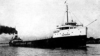
SS Emperor was a steel-hulled Canadian lake freighter in service between 1911 and 1947. She was built between 1910 and April 1911 by the Collingwood Shipbuilding Company in Collingwood, Ontario, for Inland Lines, Ltd. of Midland, Ontario. She entered service on May 3, 1911. Emperor was sold to Canada Steamship Lines of Montreal, Quebec. Under the ownership of Canada Steamship Lines, she carried a wide variety of cargoes, but most frequently iron ore to Point Edward, Ontario, where it would be transported to Hamilton, Ontario, by train. After the opening of the fourth Welland Canal, Emperor carried the ore straight to Hamilton. She was involved in several accidents throughout her career.

References

  1. 1 2 "Rossport". Geographical Names Data Base . Natural Resources Canada . Retrieved 2015-07-11.
  2. 1 2 3 4 "Rossport, Ontario (Code 350009) census profile". 2011 Census of Population . Statistics Canada. Retrieved 2012-09-24.
  3. Elevation taken from Google Earth at coordinates given in the Infobox. Accessed 2015-07-11.
  4. "Lahontan" (PDF). Geology Ontario - Historic Claim Maps. Ontario Ministry of Northern Development, Mines and Forestry. Archived from the original (PDF) on 2015-07-12. Retrieved 2015-07-11.
  5. "Local Services Boards, R.R.O. 1990, Reg. 737". Canadian Legal Information Institute. Retrieved 2015-07-11.
  6. The Canadian Guide-Book Part 2, Ernest Ingersoll, published by D.Appleton, 1892
  7. "John Bowman," in F. Brent Scollie, Thunder Bay Mayors & Councillors 1873-1945 (Thunder Bay Historical Museum Society, 2000), 55.
  8. Dominion Illustrated, October 27, 1888, Rossport fish.
  9. Monetary Times and Trade Review Insurance Chronicle, November 1888, Rossport Fish to Belfast
  10. Railway Age, April 26, 1901, Rossport, news item, P.467.
  11. Railway and Marine World, December 1907, Rossport, news item.
  12. Toronto Star, June 12, 1957, Rossport Derby, P.53
  13. Toronto Star, August 6, 1952, King Whyte, Rossport Derby
  14. Toronto Star, June 13, 1958, "Speaking on Sport", P.22
  15. YACHT GUNILDA SUNK IN LAKE SUPERIOR. (1911, Sep 02). The Globe (1844-1936) P.12
  16. "Fine yacht went down in 300 feet of water". (1911, Sep 01). Toronto Daily Star P.23
  17. Duluth Herald, September 1, 1911, "Yacht Gunilda is total wreck", P.5
  18. Toronto Star, August 11, 1971, "Diver finds ship at 310 ft, 'good as new'", P.23
  19. "The Ultimate Group of Seven Road Trip". 9 March 2018.
  20. "Wardrop Park | Group of Seven | Moments of Algoma".
  21. Montreal Gazette, October 04,1933. "Lake Port Damaged" P.11
  22. Seaman's Journal, November 01 1933, "Lake Superior's Mystery", P.170
  23. "Lake Superior National Marine Conservation Area Receives Highest Level of Federal Protection". Parks Canada. 24 June 2015. Retrieved 26 June 2015.
  24. "Wilson Island Archipelago Protected Rossport". Lake Superior Media. Retrieved 2015-07-11.
  25. "Wilson Island". Nature Conservancy of Canada. Archived from the original on 2015-07-12. Retrieved 2015-07-11.
  26. Statistics Canada Population and dwelling counts, for Canada, provinces and territories, and designated places, 2006 and 2001 censuses. Retrieved 27 August 2008.
  27. "2011 Community Profiles". 2011 Canadian Census . Statistics Canada. March 21, 2019. Retrieved 2015-07-11.
  28. "2006 Community Profiles". 2006 Canadian Census . Statistics Canada. August 20, 2019.
  29. "2001 Community Profiles". 2001 Canadian Census . Statistics Canada. July 18, 2021.

Other map sources: