Neskantaga First Nation

Last updated

Neskantaga
Neskantaga Indian Reserve
Flag of the Neskantaga First Nation.PNG
Canada Ontario location map 2.svg
Red pog.svg
Neskantaga
Coordinates: 52°12′N88°02′W / 52.200°N 88.033°W / 52.200; -88.033
Country Flag of Canada (Pantone).svg  Canada
Province Flag of Ontario.svg  Ontario
District Kenora
First NationNeskantaga
Area
  Land8.30 km2 (3.20 sq mi)
Population
 (2021) [3]
  Total244
Website neskantaga.com

Neskantaga First Nation (formerly known as Lansdowne House Indian Band) is a remote Oji-Cree First Nation band government in the northern reaches of the Canadian province of Ontario, situated along the shore of Attawapiskat Lake in the District of Kenora.

Contents

The First Nation is a signatory to Treaty 9 (originally as part of the Fort Hope Band) and has reserved for itself the 831.50 hectares (2,054.7 acres)Neskantaga Indian reserve , containing the main community of Lansdowne House Indian Settlement on Attawapiskat Lake, on the west side of the lake, which is currently the community's water source. Associated with the Neskantaga First Nation is the Summer Beaver Indian Settlement, which is shared with Nibinamik First Nation. The Lansdowne House is linked to the rest of Ontario by the Lansdowne House Airport, and by winter roads and ice roads to points south, via the Northern Ontario Resource Trail. As of November 2011, there is a total registered population of 414 people, of whom 304 people live on their own reserve.

Neskantaga is a fly-in community and is therefore not accessible by year-round road. [4]

The Ring of Fire is 500 kilometres northeast of Thunder Bay in the remote James Bay lowlands, and contains a vast, rich and untapped mineral camp of world-class chromite, nickel, copper and palladium deposits.

Governance

The First Nation elects its officials under the Custom Electoral System. The most recent officials were Peter Moonias as Chief, and Bill Mequanawap, Christopher Moonias, Kelvin Moonias and William Moonias as Councillors; their two-year term ended on 03/31/2013.

The First Nation's council is a member of the Matawa First Nations, a local Chiefs Council, and of Nishnawbe Aski Nation, a Tribal Political Organisation representing most of the First Nations in northern Ontario.

Location

The Neskantaga First Nations is about 450 kilometres north of Thunder Bay, Ontario. Neskantaga is at the headwaters of the Attawapiskat River in the James Bay Lowlands, in a "pristine boreal setting known for bears, wolverines and excellent fishing" with many bodies of water and a "landscape weaving among them". [5] The community was relocated in the late 1980s to a peninsula known as on Grandmother's Point, on the west side of Attawapiskat Lake. [6]

History

According to their website, the "ancient Anishnawbe communities [date] back to at least 3000 BC." [7] The "Attawapiskat and Otoskwin rivers surrounding Neskantaga merge into a delta with significant brackish tidal marshes" and the area was once "part of a major trade route". [7] There were fur-trading sites since the early 1880s in the area. [7]

Until the 1980s, the community members had lived for many years in log cabins in Lansdowne House where the Indian Affairs agency had a cabin. For many years they fetched their water from the agency's cabin as it was the only building to have plumbing. Because of ongoing issues with both infrastructure and flooding, the community was relocated in the 1980s to its current site, which is about a 20 km from its previous location. [6] A 2020 CBC article described how the community members had given up their cabins, which were then demolished "for the promise of a better life at a new location with improved services, including clean running water in each house." [6]

Ring of Fire

The Neskantaga First Nation is one of three First Nations that are most profoundly impacted by the Northern Ontario Ring of Fire, along with the Marten Falls First Nation, and the Webequie First Nation. An open pit mine proposed by Cliffs is on Neskantaga First Nation land. [8]

On February 7, 2009, Ontario Minister Rick Bartolucci released the White Paper regarding the Northern Ontario Ring of Fire, including the announcement of decisions made regarding Cliffs and the province that would negatively impact Treaty 9 land. According to the Neskantaga First Nation, the agreements with Cliffs about Treaty 9 lands, was a "blatant and illegal attempt by Ontario to expand its own influence and jurisdiction in Treaty No. 9. [9] "Ontario has twice pushed back the deadline for input" in Ring of Fire planning, but the community says it has not enough time. [10]

By December 2020, Ontario there were tensions between the Ontario government, Neskantaga First Nation, and the nearby Webequie First Nation. The Webequie First Nation was leading an "environmental assessment process for a supply road leading to the Ring of Fire mining region" but the Neskantaga First Nation raised concerns about their own lack of meaningful participation in the assessment process during the COVID-19 pandemic. [11] The participation of the Neskantaga First Nation was further complicated by a forced evacuation in October 2020 caused by the community's "precarious water supply." [11]

On April 5, 2021, the Attawapiskat, Fort Albany, and Neskantaga First Nations declared a moratorium on Ring of Fire development. [12]

Long-term drinking water advisories (DWA)

The water source for the Neskantaga community is Attawapiskat Lake. The lake often has a "naturally occurring “colour” from the roots of trees, plants and other organic matter" and has to be filtered before it can be used as drinking water. [5]

By June 2021, the Neskantaga First Nation was still under a Long-term Drinking Water Advisory, which was first put in place in 1995. The 300 community members rely on the community’s Reverse osmosis (RO) machine for water. [5] It is a "laborious process" in which individual households have to haul sleds several times a week to and from the local hotel to use the unreliable machine. They also depend on shipments of bottled water. [5]

The DWA is the longest in Canada and it began to gain national attention when Canadian news outlets began to cover the story from 2004 to 2016 about the unsafe water supply. In 2006, the 2005 government plan to modernize water supplies was cancelled following a change of government. [13]

East of Neskantaga and 90 kilometres (56 mi) west of Attawapiskat First Nation, in the Northern Ontario Ring of Fire, in the James Bay Lowlands, De Beers' Victor Diamond Mine—which was operational from 2009 until 2020 when it was decommissioned—had provided "clean water for hundreds of workers" on its open pit mining site. [5] To community members, this is evidence that the inability to provide drinking water is not a technical but a political issue. [5]

In 1993, the federal Indian Affairs department "paid for the construction of a natural sand, low-filter water treatment plant" [6] to filter the water from Lake Neskantaga. By February 1, 1995, it was evident that the water treatment plant had not been "built properly", [14] and was not adequately disinfecting the water. [6] The community was placed under a "boil water advisory" which has remained in place ever since. [14] [15]

In 2016, then-Indigenous Affairs Minister Carolyn Bennett visited Neskantaga, which at that time had a population of 350, and announced that the federal government would "invest approximately $8.8 million to help upgrade the community's water treatment system, including an addition to the existing water plant with new treatment technology and additional reservoir storage capacity to meet the community's long-term needs." [16]

In October 2020, the Neskantaga First Nation fully evacuated the reserve after test results showed high levels of hydrocarbons in the water supply, [17] [18] [19] caused by a faulty pump installed by Razar Contracting Services. [20] On December 21, 2020, over 250 members returned to the reserve. [21]

By December 2020, the new water treatment plant was commissioned and by March 2021, the upgrade and expansion was approaching final completion. There were 374 people living on the reserve and the boil water advisory affected "76 households and 6 community buildings." [22]

Climate

Neskantaga First Nation has a subarctic climate (Dfc). Summers consist of mild, sometimes warm days with cool nights and rain usually falling on a little more than half of all summer days. Winters are brutally cold with nights reaching dangerously cold temperatures and annual snowfall averaging 95.1 inches, (241.6 cm) falling on 89 separate days. Winter usually begins sometime during October and can easily last well into April.

Climate data for Neskantaga First Nation (1971−2000, extremes 1941–present [note 1] )
MonthJanFebMarAprMayJunJulAugSepOctNovDecYear
Record high humidex 2.79.917.225.044.540.944.540.732.825.416.17.144.5
Record high °C (°F)5.4
(41.7)
9.9
(49.8)
22.4
(72.3)
27.9
(82.2)
33.8
(92.8)
38.5
(101.3)
36.7
(98.1)
35.0
(95.0)
30.7
(87.3)
26.2
(79.2)
20.5
(68.9)
7.4
(45.3)
38.5
(101.3)
Average high °C (°F)−16.9
(1.6)
−12.3
(9.9)
−4.4
(24.1)
4.8
(40.6)
13.5
(56.3)
18.9
(66.0)
22.4
(72.3)
20.5
(68.9)
13.0
(55.4)
5.8
(42.4)
−3.7
(25.3)
−13.7
(7.3)
4.0
(39.2)
Daily mean °C (°F)−22.3
(−8.1)
−18.8
(−1.8)
−11.8
(10.8)
−1.6
(29.1)
7.3
(45.1)
13.5
(56.3)
17.2
(63.0)
15.6
(60.1)
8.9
(48.0)
2.4
(36.3)
−7.2
(19.0)
−18.5
(−1.3)
−1.3
(29.7)
Average low °C (°F)−27.7
(−17.9)
−25.2
(−13.4)
−19.2
(−2.6)
−8.1
(17.4)
1.2
(34.2)
8.1
(46.6)
12.0
(53.6)
10.7
(51.3)
4.8
(40.6)
−0.9
(30.4)
−10.6
(12.9)
−23.2
(−9.8)
−6.5
(20.3)
Record low °C (°F)−47.8
(−54.0)
−45.6
(−50.1)
−42.8
(−45.0)
−32.8
(−27.0)
−17.2
(1.0)
−4.4
(24.1)
−0.1
(31.8)
−0.9
(30.4)
−7.2
(19.0)
−16.9
(1.6)
−34.0
(−29.2)
−45.8
(−50.4)
−47.8
(−54.0)
Record low wind chill −57.6−58.3−50.4−41.3−26.8−7.9−4.4−1.8−15.5−21.8−44.2−52.5−58.3
Average precipitation mm (inches)26.6
(1.05)
21.8
(0.86)
31.6
(1.24)
41.9
(1.65)
50.7
(2.00)
80.8
(3.18)
107.5
(4.23)
102.7
(4.04)
92.6
(3.65)
56.6
(2.23)
54.8
(2.16)
32.1
(1.26)
699.5
(27.54)
Average rainfall mm (inches)0.0
(0.0)
0.2
(0.01)
3.3
(0.13)
19.9
(0.78)
43.3
(1.70)
79.3
(3.12)
107.5
(4.23)
102.7
(4.04)
88.8
(3.50)
34.1
(1.34)
8.6
(0.34)
1.0
(0.04)
488.7
(19.24)
Average snowfall cm (inches)31.3
(12.3)
26.5
(10.4)
33.0
(13.0)
24.2
(9.5)
8.0
(3.1)
1.6
(0.6)
0.0
(0.0)
0.0
(0.0)
3.9
(1.5)
24.0
(9.4)
51.2
(20.2)
38.0
(15.0)
241.6
(95.1)
Average precipitation days (≥ 0.2 mm)13.011.611.29.511.815.016.015.817.715.815.915.5168.9
Average rainy days (≥ 0.2 mm)0.00.211.54.210.114.916.015.816.99.72.20.2891.8
Average snowy days (≥ 0.2 cm)13.311.910.66.83.20.530.00.01.89.315.216.288.7
Source: Environment Canada [23] [24]

Notes

  1. Long term records have been recorded at various climate stations in or nearby Neskantaga First Nation since 1941

Related Research Articles

<span class="mw-page-title-main">Moosonee</span> Town in Ontario, Canada

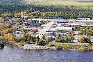
Moosonee is a town in northern Ontario, Canada, on the Moose River approximately 19 km (12 mi) south of James Bay. It is considered to be "the Gateway to the Arctic" and has Ontario's only saltwater port. Nearby on Moose Factory Island is the community of Moose Factory to which it is connected by water taxi in the summer and ice road in the winter.

In Canada, an Indian reserve is defined by the Indian Act as a "tract of land, the legal title to which is vested in His Majesty, that has been set apart by His Majesty for the use and benefit of a band." Reserves are areas set aside for First Nations, one of the major groupings of Indigenous peoples in Canada, after a contract with the Canadian state, and are not to be confused with indigenous peoples' claims to ancestral lands under Aboriginal title.

<span class="mw-page-title-main">Greenstone, Ontario</span> Municipality in Ontario, Canada

Greenstone is an amalgamated town in the Canadian province of Ontario with a population of 4,636 according to the 2016 Canadian census. It stretches along Highway 11 from Lake Nipigon to Longlac and covers 2,767.19 km2 (1,068.42 sq mi).

First Nations in Ontario constitute many nations. Common First Nations ethnicities in the province include the Anishinaabe, Haudenosaunee, and the Cree. In southern portions of this province, there are reserves of the Mohawk, Cayuga, Onondaga, Oneida, Seneca and Tuscarora.

<span class="mw-page-title-main">Attawapiskat First Nation</span> First Nation in Kenora District, Ontario, Canada

The Attawapiskat First Nation is an isolated First Nation located in Kenora District in northern Ontario, Canada, at the mouth of the Attawapiskat River on James Bay. The traditional territory of the Attawapiskat First Nation extends beyond their reserve up the coast to Hudson Bay and hundreds of kilometres inland along river tributaries. The community is connected to other towns along the shore of James Bay by the seasonal ice road/winter road constructed each December, linking it to the towns of Kashechewan First Nation, Fort Albany, and Moosonee Attawapiskat, Fort Albany, and Kashechewan operate and manage the James Bay Winter Road through the jointly owned Kimesskanemenow Corporation, named after the Cree word for "our road" -kimesskanemenow. Attawapiskat is the most remote northerly link on the 310 km (190 mi) road to Moosonee. They control the reserves at Attawapiskat 91 and Attawapiskat 91A.

<span class="mw-page-title-main">Kashechewan First Nation</span> Indian settlement in Ontario, Canada

The Kashechewan First Nation is a Cree First Nation band government located near James Bay in Northern Ontario, Canada. The community is located on the northern shore of the Albany River. Kashechewan First Nation is one of two communities that were established from Old Fort Albany in the 1950s. The other community is Fort Albany First Nation, which is now located on the southern bank of the Albany River. The community is connected to other towns along the shore of James Bay by the seasonal ice road/winter road, linking it to the towns of Attawapiskat, Fort Albany, and Moosonee.

Eabametoong, also known as Fort Hope or Eabamet Lake by Canada Post, is an Ojibwe First Nations band government in Kenora District, Ontario, Canada. Located on the shore of Eabamet Lake in the Albany River system, the community is located approximately 300 km (190 mi) northeast of Thunder Bay and is accessible only by airplane via Fort Hope Airport or water, or by winter/ice roads, which connect the community to the Northern Ontario Resource Trail. The Eabametoong First Nation Reserve is completely surrounded by territory of the Unorganized Kenora District.

Webequie First Nation is located on the northern peninsula of Eastwood Island on Winisk Lake, 540 km (336 mi) north of Thunder Bay in Ontario, Canada. Webequie is a fly-in community with no summer road access. The primary way into the community is by air to Webequie Airport or winter road, which connects to the Northern Ontario Resource Trail. The First Nation have the 34,279 ha Webequie Indian reserve. The Webequie or Webiqui Indian Settlement also have reserve status. Webequie First Nation is a member of the Matawa First Nations, a Regional Chiefs' Council and a member of the Nishnawbe Aski Nation.

<span class="mw-page-title-main">NAC Air</span>

NAC Air was a Canadian regional airline that began operations in 2000. Its main base was at the Thunder Bay International Airport. NAC Air was a 100% First Nations-owned company, owned by the communities of Eabametoong, Neskantaga, Webequie, Sachigo Lake, and Sandy Lake

Nibinamik First Nation, also known as Summer Beaver Band, is a small Oji-Cree First Nation reserve in Northern Ontario, located on the Summer Beaver Settlement that is connected to the rest of the province by its airport, and a winter/ice road that leads to the Northern Ontario Resource Trail.

<span class="mw-page-title-main">Nishnawbe Aski Nation</span>

Nishnawbe Aski Nation is a political organization representing 51 First Nation communities across Treaty 9 and Treaty 5 areas of Northern Ontario, Canada. Re-organized to its present form in 1981, NAN's original objective was "to represent the social and economic aspirations of our people at all levels of government in Canada and Ontario until such time as real effective action is taken to remedy our problems."

<span class="mw-page-title-main">Constance Lake First Nation</span> Place

Constance Lake First Nation is an Oji-Cree First Nations band government located on the shores of Constance Lake near Hearst, Cochrane District in northeastern Ontario, Canada. It is directly north of the community of Calstock along a continuation of Ontario Highway 663. Constance Lake First Nation is home to close to 1605 members of Cree and Ojibway with approximately 820 living on reserve. The reserves, Constance Lake 92 and English River 66, total 7,686 acres (3,110 ha) in size.

<span class="mw-page-title-main">Matawa First Nations</span>

Matawa First Nations, officially as the Matawa First Nations Management, Inc., is a non-profit Regional Chiefs' Council representing Ojibway and Cree First Nations in Northern Ontario, Canada. The Council provides advisory services and program delivery to its ten member-Nations.

McFaulds Lake is a lake located in the Unorganized Part of Kenora District in northwestern Ontario, Canada. It is part of the James Bay drainage basin and is in the Hudson Bay Lowlands area. There are two unnamed inflows, at the south and north. The primary outflow is an unnamed stream at the northeast leading to the Attawapiskat River, which itself flows to James Bay.

Attawapiskat Lake is a lake in Kenora District, Ontario, Canada. The primary inflows are the Otoskwin River, the Marten-Drinking River and the Pineimuta River. The two outflows are the Attawapiskat River and the North Channel, which itself flows into the Attawapiskat River.

The Victor Mine was the first Canadian diamond mine located in Ontario, and De Beers' second diamond mine in Canada. It is located in the Northern Ontario Ring of Fire, in the James Bay Lowlands 90 kilometres (56 mi) west of Attawapiskat in the remote northern part of the province. In June 2005, the Attawapiskat First Nation voted in favour (85.5%) of ratifying the Impact Benefit Agreement (IBA). Construction of the mine began in February 2006 which created 3200 positions; mining and operations will create around 400 permanent positions. The Victor Mine is an open-pit mine, with a processing plant, workshops, and an airstrip located on site. By 2013–2014 royalties collected from De Beers Victor Mine amounted to $226. At that time De Beers was continuing to pay off its "$1 billion investment to build the mine and from now until it closes, the company expects to pay tens of millions of dollars in royalties." The mine completed mining and processing in 2019 and has moved to a shut-down phase including demolition of infrastructure and rehabilitation of the site.

The Ring of Fire is a vast, mineral-rich region located in the remote James Bay Lowlands of Northern Ontario, Canada. Spanning approximately 5,000 square kilometres (1,900 sq mi), the area is rich in chromite, nickel, copper, platinum group elements, gold, zinc, and other valuable minerals. Discovered in the early 21st century, the Ring of Fire is considered one of the most significant mineral deposits in Canada, with the potential to greatly impact the nation's economy and global mining industry. The development of this region has been a subject of ongoing debate, as stakeholders weigh the economic benefits against environmental concerns and the rights of Indigenous communities in the area. Despite these challenges, the Ring of Fire had remained a focal point for the Canadian mining sector and government, as well as international investors. By July 2023, the federal and provincial governments were no longer in agreement on priorities for federal funding of the Ring of Fire. Georgia Lake lithium project, KGHM's Victoria mine proposal and the Onaping Depth nickel project—which will produce minerals required for the low carbon economy—had become higher priorities, particularly as the Ring of Fire project is situated in a region of "vast, environmentally sensitive...peatlands".

<span class="mw-page-title-main">Wasaya Airways</span> First Nations-owned airline in Ontario, Canada

Wasaya Airways LP is a First Nations-owned domestic airline with its headquarters in Thunder Bay, Ontario, Canada. Its main hubs are the Thunder Bay International Airport and the Sioux Lookout Airport; however, it also offers a charter and cargo service from a base in Red Lake Airport and Pickle Lake Airport. In 2003, Wasaya Airways bought the rights to serve remote First Nations communities from Bearskin Airlines. The airline also supplies food, clothing, hardware and other various supplies to 25 remote communities in Ontario.

<span class="mw-page-title-main">North Star Air</span> Canadian charter and cargo airline

North Star Air is a Canadian charter, passenger and cargo airline headquartered in Thunder Bay, Ontario, with secondary passenger hub in Sioux Lookout, Ontario, and cargo hubs located in Pickle Lake, Red Lake, Kapuskasing and Thompson, Manitoba. The majority of destinations served are First Nations communities, with regular service to 18 airports under "Flex Flight Passenger Service", and other regional destinations under an on-demand basis. Founded in 1997 as a floatplane operator with two DHC-2 Beaver aircraft based in Pickle Lake, the airline has grown over the years and came under new ownership in 2012. In 2015 Cargo North and North Star Air merged under the North Star banner. In 2022 North Star Air opened up their brand new cargo depot based in Winnipeg.

In Canada, First Nations communities have been under long-term drinking water advisories (DWAs) for decades. A long-term drinking water advisory is an advisory that has been in place for over a year.

References

  1. "Neskantaga census profile". 2011 Census of Population . Statistics Canada. Retrieved 22 June 2015.
  2. "Neskantaga census profile". 2016 Census of Population . Statistics Canada. Retrieved 22 June 2015.
  3. Statistics Canada. 2022. (table). Census Profile. 2021 Census of Population. Statistics Canada Catalogue no. 98-316-X2021001. Ottawa. Released April 27, 2022. https://www12.statcan.gc.ca/census-recensement/2021/dp-pd/prof/index.cfm?Lang=E (accessed June 21, 2022).
  4. "Neskantaga evacuees to return home in December but still won't have access to drinking water". APTN National News. Nov 12, 2020. Retrieved May 20, 2021.
  5. 1 2 3 4 5 6 Edwards, Kyle (January 21, 2019). "This First Nation is getting clean tap water for the first time in 25 years". Macleans. Retrieved June 28, 2021.
  6. 1 2 3 4 5 Stefanovich, Olivia (December 17, 2020). "After evacuating twice over tainted water, Neskantaga residents plan their return home". CBC News. Retrieved June 28, 2021.
  7. 1 2 3 "Who We Are – Neskantaga" . Retrieved June 28, 2021.
  8. "'Kill me first,' Neskantaga chief tells Cliffs". CBC. Thunder Bay. Retrieved June 28, 2021.
  9. "A New Deal for First Nations and the North". Neskantaga First Nation. May 9, 2012. Archived from the original on 2012. Retrieved October 23, 2018.
  10. NeskantagaMaclean's Magazine, January 2021, p.27."
  11. 1 2 Smith, Marie-Danielle (December 15, 2020). "10 pivotal First Nations rights disputes to watch in 2021". Macleans. Retrieved June 28, 2021.
  12. Attawapiskat, Fort Albany, and Neskantaga First Nations (April 5, 2021). "First Nations Declare Moratorium on Ring of Fire Development". Newswire. Toronto, Ontario. Retrieved June 28, 2021.{{cite news}}: CS1 maint: multiple names: authors list (link)
  13. Galloway, Gloria (December 6, 2015). "Unresolved water advisories creating 'health emergency' for First Nations". The Globe and Mail. Retrieved May 20, 2021.
  14. 1 2 ""This is not the country you believe it is," Neskantaga First Nation chief says amid water crisis". CBC News. October 26, 2020. Retrieved May 20, 2021.
  15. Porter, Jody (October 27, 2020). "Neskantaga First Nation water crisis shows 'apartheid system' of clean water access, NDP MPP says". CBC News. Retrieved May 20, 2021.
  16. Porter, Jody (July 28, 2017). "Canada plans to end 22-year boil water advisory in Neskantaga First Nation, next year". CBC. Retrieved June 28, 2021.
  17. "Chief says Neskantaga First Nation to fully evacuate amid tainted water results". Global News. October 24, 2020. Retrieved May 20, 2021.
  18. "Mining push continues despite water crisis in Neskantaga First Nation and Ontario's Ring of Fire". The Conversation. CBC News. November 22, 2020. Retrieved May 20, 2021.
  19. Porter, Jody (October 26, 2020). "Few left behind in Neskantaga First Nation prepare for winter without water" . Retrieved May 20, 2021.
  20. Stefanovich, Olivia (Dec 17, 2020). "After evacuating twice over tainted water, Neskantaga residents plan their return home". CBC News. Retrieved June 22, 2021.
  21. Stefanovich, Olivia (December 21, 2020). "Neskantaga evacuees relieved to be home, but distrust about water quality lingers". CBC News. Retrieved May 20, 2021.
  22. Canada, Government of Canada; Indigenous Services (March 4, 2021). "Neskantaga" . Retrieved June 28, 2021.
  23. "Lansdowne House". Canadian Climate Normals 1971–2000. Environment Canada. Archived from the original on July 3, 2019. Retrieved July 3, 2019.
  24. "Long Term Climate Extremes for Lansdowned Area (Virtual Station ID: VSON87V)". Daily climate records (LTCE). Environment Canada. Archived from the original on November 11, 2021. Retrieved November 11, 2021.