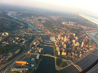
North Side refers to the region of Pittsburgh, Pennsylvania, located to the north of the Allegheny River and the Ohio River. The term "North Side" does not refer to a specific neighborhood, but rather to a disparate collection of contiguous neighborhoods.

Downtown Pittsburgh, colloquially referred to as the Golden Triangle, and officially the Central Business District, is the urban downtown center of Pittsburgh, Pennsylvania, United States. It is located at the confluence of the Allegheny River and the Monongahela River whose joining forms the Ohio River. The triangle is bounded by the two rivers.
Interstate 579 (I-579) is a north–south Interstate Highway entirely within Pittsburgh, Pennsylvania. The highway is 2.73 miles (4.39 km) long. I-579 is also known as the Crosstown Boulevard since it crosses the backside of Downtown Pittsburgh.

Allegheny Center is a neighborhood on Pittsburgh's North Side. Its zip code is 15212, and it has representation on Pittsburgh City Council by both council members for District 6 and District 1 (Northside).

California-Kirkbride is a neighborhood on Pittsburgh, Pennsylvania's North Side.

Esplen is a neighborhood in Pittsburgh, Pennsylvania's West End. It has a zip code of 15204, and has representation on Pittsburgh City Council by the council member for District 2.
Manchester is a North Side neighborhood in Pittsburgh, Pennsylvania. The neighborhood is represented on Pittsburgh City Council by the District 6. Manchester houses PBF Battalion 1 & 37 Engine, and is covered by PBP Zone 1 and the Bureau of EMS Medic 4. The neighborhood includes the Manchester Historic District, which protects, to some degree, 609 buildings over a 51.6-acre (20.9 ha) area. The district was listed on the National Register of Historic Places in 1975. It uses ZIP code of 15233.

Marshall-Shadeland is a neighborhood on Pittsburgh, Pennsylvania's North Side. It has a zip codes of both 15212 and 15214, and has representation on Pittsburgh City Council by the council member for District 1.
North Shore is a neighborhood in Pittsburgh's North Side. Its zip code is 15212.

Troy Hill is a neighborhood on Pittsburgh, Pennsylvania's North Side. It has a zip code of 15212, and has representation on Pittsburgh City Council by the council member for District 1.

West End Village is a neighborhood in Pittsburgh, Pennsylvania's west city area. It has a zip code of 15220, and has representation on Pittsburgh City Council by the council member for District 2.

Greater Pittsburgh is the metropolitan area surrounding the city of Pittsburgh in Western Pennsylvania, United States. The region includes Allegheny County, Pittsburgh's urban core county and economic hub, and seven adjacent Pennsylvania counties: Armstrong, Beaver, Butler, Fayette, Lawrence, Washington, and Westmoreland in Western Pennsylvania, which constitutes the Pittsburgh, PA Metropolitan Statistical Area MSA as defined by the U.S. Census Bureau.
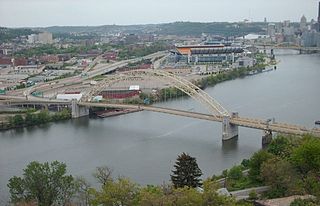
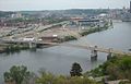
The West End Bridge is a steel tied-arch bridge over the Ohio River in Pittsburgh, Pennsylvania, approximately 1 mile (1.6 km) below the confluence of the Allegheny and Monongahela Rivers. It connects the West End to the Chateau neighborhood on the North Side of Pittsburgh.

A large metropolitan area that is surrounded by rivers and hills, Pittsburgh has an infrastructure system that has been built out over the years to include roads, tunnels, bridges, railroads, inclines, bike paths, and stairways; however, the hills and rivers still form many barriers to transportation within the city.
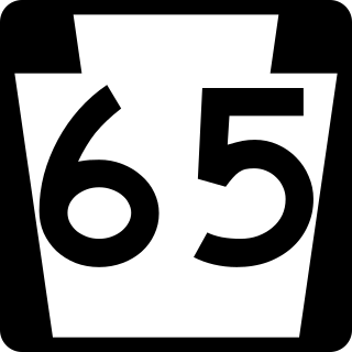
Pennsylvania Route 65 is a major 51-mile-long (82 km) state highway located in western Pennsylvania, United States. The route, traveling north–south from the Interstate 279/U.S. Route 19 Truck concurrency in Pittsburgh north to the PA 108/PA 168 concurrency in New Castle, connects downtown Pittsburgh to the northwestern portion of the Pittsburgh Metropolitan Area. PA 65 is similar in its purpose to PA 18 and PA 51, both of which run parallel to PA 65 at one point or another; however, the three routes pass through different cities for most of their respective alignments.

The P&W Subdivision is a railroad line owned and operated by CSX Transportation, the Allegheny Valley Railroad (AVR), and the Buffalo and Pittsburgh Railroad (BPRR) in the U.S. state of Pennsylvania. The line runs from Rankin north through Pittsburgh to West Pittsburg along a former Baltimore and Ohio Railroad line, once the Pittsburgh and Western Railroad.

North Shore Riverfront Park is a small municipal park along the north banks of the Allegheny and Ohio Rivers across from Downtown Pittsburgh, Pennsylvania, United States.

The North Shore Connector is a light-rail extension opened in 2012 in Pittsburgh, Pennsylvania. The connector extends the Pittsburgh Light Rail system from its previous terminus at Gateway Center Station in the Central Business District to the new North Side Station and Allegheny Station on the North Shore by way of a tunnel under the Allegheny River. The Connector extends the light rail system's "Free Fare Zone", enabling passengers to ride to and from Pittsburgh's rapidly growing North Shore neighborhood for free.

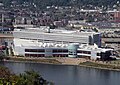
The Rivers Casino is a casino in Pittsburgh, Pennsylvania. It is owned by Holdings Acquisition Co. L.P., a joint venture of Walton Street Capital LLC and High Pitt Gaming LP. Located in Pittsburgh's Chateau neighborhood along the Ohio River, adjacent to the Kamin Science Center and nearby Heinz Field and PNC Park, it had its groundbreaking in December 2007 and opened on August 9, 2009.