West End (Pittsburgh)

Last updated

West End
West End Valley
(formerly Temperanceville)
OldStoneInnPittsburgh.jpg
The Old Stone Inn located at 434 Greentree Road, possibly circa 1756, may be one of the oldest buildings in the region.
Pgh locator west end.svg
Coordinates: 40°26′08″N80°02′06″W / 40.4355°N 80.0351°W / 40.4355; -80.0351
CountryUnited States
State Pennsylvania
County Allegheny County
City Pittsburgh
Area
[1]
  Total0.2 sq mi (0.5 km2)
Population
 (2010) [1]
  Total254
  Density1,300/sq mi (490/km2)
ZIP Code
15220
Historical population
YearPop.±%
1940 1,984    
1950 1,820−8.3%
1960 1,702−6.5%
1970 920−45.9%
1980 604−34.3%
1990 441−27.0%
2000 466+5.7%
2010 254−45.5%
[2] [3]
Source: University of Pittsburgh [4]

West End Village (originally named Temperanceville) is a neighborhood in Pittsburgh, Pennsylvania's west city area. It has a zip code of 15220, and has representation on Pittsburgh City Council by the council member for District 2 (West Neighborhoods).

Contents

The neighborhood lies in a small valley south of the Ohio River and less than a mile from downtown Pittsburgh. Temperanceville was founded as a dry town and was annexed to the City of Pittsburgh in 1874. [5] To support neighborhood businesses, the Urban Redevelopment Authority added the West End Village as a Mainstreet Pittsburgh district in 2009. [6] The West End Bridge crosses the Ohio River and connects the neighborhood to the North Side of the city. Carson St. connects it to Station Square and the South Side to the east, and the borough of McKees Rocks to the west.

Region

The term "West End" is also used to refer to the surrounding region, which includes the West End Valley in addition to western neighborhoods Sheraden, Elliott, Windgap, Esplen, Ridgemont, Westwood, Oakwood, East Carnegie, Chartiers City, Fairywood, Crafton Heights, and Banksville. The West End of Pittsburgh is mostly residential, with some industry and a relative paucity of commercial districts in comparison to the rest of the city. The West End region has few notable tourist attractions other than the West End Overlook, a small hilltop park in the Elliott neighborhood that offers an excellent view of the Golden Triangle (Downtown Pittsburgh).

The term "West End" is often mistakenly used to refer to the area southwest of the Ohio River. Upon annexation, the City of Pittsburgh renamed the Borough of Temperanceville as West End; Temperanceville was its own entity (incorporated 1860 [7] ) on the valley floor through which Saw Mill Run flows toward the Ohio River, between the Coal Hill end of Mt. Washington upriver, and River Hill downriver (site of the Elliott bluff lookout, a.k.a. the West End Overlook (c.1961)/West End-Elliott Overlook (c.2004) the top of which is in a neighborhood corner of the (annexed) community of Elliott.

The Pittsburgh southwest communities are essentially residential areas supported by local businesses, with ready access to the rest of the city and surrounding areas and highway systems. Over the past 30+ years the West End neighborhood (Temperanceville) has suffered the demolition of much indigenous residential architecture and the removal of most of its tenant units from the rental market, displacing a once substantial multicultural low-middle-fixed income population in favor of attempts to attract business.

The West End has three designated historic landmark buildings: the German (now Jerusalem Baptist) Church, the 1899 Carnegie Branch Library (spoken for by Andrew Carnegie himself, 2nd in the Pittsburgh Carnegie system, and home of the first Library Story Hour anywhere), and the Old Stone Tavern, which may pre-date the Fort Pitt Blockhouse as the oldest building west of the Alleghenies.

The "overlook" (once one of the most-visited sites in Allegheny County) has drawn fewer visitors since 2004, when a 2.5 million dollar park improvement eliminated historically available vehicle access to the bluff-top, thereby impacting all-season visiting. Elliott and Crafton Heights also share the Obey House (1823), a prime historical example of a "road house" on the Steubenville Pike (the land route West from Pittsburgh.)

Highways

West End Bypass / Banksville Circle

The West End Bypass is a 1.1 stretch of highway (designated as Saw Mill Run Blvd/U.S. 19, PA 51), running from the West End exit interchange on the Penn Lincoln Parkway (Exit 69C) to the West End Circle. When this bypass opened in 1951, its South Hills connector was the Banksville Circle, a predecessor thoroughfare to the Parkway and Fort Pitt Tunnels. This circle provided direct access to the West End via Woodville Avenue. It was removed by the late 1950s with the construction of the Penn Lincoln Parkway. However, the Woodville Avenue connector still exists, accessible via Parkway Exit 69C and Carnegie/Airport exit from the West End Bypass.

West End Circle

The West End Circle is the circumference of traffic south of the West End Bridge, brought together by the West End Bypass (see above), South Main Street (PA Route 60—southern terminus), Steuben Street, and West Carson Street (PA 51/PA 837—northern terminus). The Norfolk Southern railway overpass (formerly Pennsylvania Railroad) runs straight through the circle, and Wheeling & Lake Erie Railroad ran across Steuben Street, across a trestle and alongside the West End Bypass.

A complete reconfiguration of the West End Circle started in October 2007, including new bridges and new improved connectors. A new underpass was dug under the Norfolk Southern Railroad for straight access to the West End Bridge northbound and West End Bypass southbound. The West End segment of the Wheeling and Lake Erie Railroad has been discontinued as the track on Steuben Street and trestle over South Main Street have been removed. [8] The project was completed in October 2010. [9]

See also

Related Research Articles

<span class="mw-page-title-main">Downtown Pittsburgh</span> Neighborhood of Pittsburgh in Allegheny County, Pennsylvania, United States

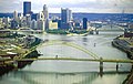
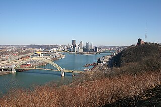
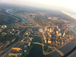
Downtown Pittsburgh, colloquially referred to as the Golden Triangle, and officially the Central Business District, is the urban downtown center of Pittsburgh, Pennsylvania, United States. It is located at the confluence of the Allegheny River and the Monongahela River whose joining forms the Ohio River. The triangle is bounded by the two rivers.

<span class="mw-page-title-main">Interstate 376</span> Highway in Pennsylvania

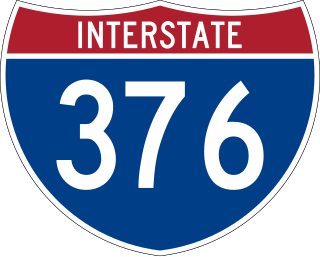
Interstate 376 (I-376) is a major auxiliary route of the Interstate Highway System in the US state of Pennsylvania, located within the Allegheny Plateau. It runs from I-80 near Sharon south and east to a junction with the Pennsylvania Turnpike in Monroeville, after having crossed the Pennsylvania Turnpike at an interchange in Big Beaver. The route serves Pittsburgh and its surrounding areas and is the main access road to Pittsburgh International Airport (PIT). Portions of the route are known as the Beaver Valley Expressway, Southern Expressway, and Airport Parkway. Within Allegheny County, the route runs along the majority of the Penn-Lincoln Parkway, known locally as Parkway West and Parkway East. It is currently the ninth-longest auxiliary Interstate route in the system and second only to I-476 within Pennsylvania.

<span class="mw-page-title-main">Lincoln–Lemington–Belmar</span> Neighborhood of Pittsburgh in Allegheny County, Pennsylvania, United States

Lincoln–Lemington–Belmar is a neighborhood in Pittsburgh, Pennsylvania. It is located in the northeastern section of the city and spans the Allegheny River. Lincoln–Lemington–Belmar houses PBF 15 Engine, and is covered by PBP Zone 5 and the Bureau of EMS Medic 1.

<span class="mw-page-title-main">Elliott (Pittsburgh)</span> Neighborhood in Allegheny County, Pennsylvania, United States

Elliott is a small, hilly neighborhood in Pittsburgh, Pennsylvania, United States' West End Region. Elliott is represented on the Pittsburgh City Council by the council member for District 2, and uses the ZIP code 15220.

<span class="mw-page-title-main">Allegheny County belt system</span> Allegheny County belt system

The Allegheny County Belt System color codes various county roads to form a unique system of routes in Allegheny County, Pennsylvania, and around the city of Pittsburgh.

<span class="mw-page-title-main">Banksville (Pittsburgh)</span> Neighborhood of Pittsburgh in Allegheny County, Pennsylvania, United States

Banksville is a neighborhood in Pittsburgh, Pennsylvania. The neighborhood of Banksville is located in the West End of the city and borders the South Hills region. Real estate agencies frequently refer to the Banksville area as Greentree City due to Banksville's shared border with the borough of Green Tree. It has two zip codes of both 15220 and 15216, and has representation in Pittsburgh City Council by the council member for District 2. Theresa Kail-Smith is the current Councilperson for district two. Banksville's primary corridor, Banksville Road, is frequently used as a gateway between the South Hills of Pittsburgh and downtown Pittsburgh via the Fort Pitt Tunnels. Banksville, formerly Union Township, joined the City of Pittsburgh around 1928.

<span class="mw-page-title-main">Chateau (Pittsburgh)</span> Neighborhood of Pittsburgh in Allegheny County, Pennsylvania, United States

Chateau is a North Side neighborhood in Downtown Pittsburgh, Pennsylvania. It has representation on Pittsburgh City Council by the council member for District 6. It is on the banks of the Ohio River and is separated from the neighborhood of Manchester by PA Route 65.

<span class="mw-page-title-main">Esplen (Pittsburgh)</span> Neighborhood of Pittsburgh in Allegheny County, Pennsylvania, United States

Esplen is a neighborhood in Pittsburgh, Pennsylvania's West End. It has a zip code of 15204, and has representation on Pittsburgh City Council by the council member for District 2.

<span class="mw-page-title-main">Manchester (Pittsburgh)</span> Neighborhood in Pittsburgh, Pennsylvania, United States

Manchester is a North Shore neighborhood in Pittsburgh, Pennsylvania. The neighborhood is represented on Pittsburgh City Council by the District 6. Manchester houses PBF Battalion 1 & 37 Engine, and is covered by PBP Zone 1 and the Bureau of EMS Medic 4. The neighborhood includes the Manchester Historic District, which protects, to some degree, 609 buildings over a 51.6-acre (20.9 ha) area. The district was listed on the National Register of Historic Places in 1975. It uses ZIP code of 15233.

<span class="mw-page-title-main">Marshall-Shadeland</span> Neighborhood of Pittsburgh in Allegheny County, Pennsylvania, United States

Marshall-Shadeland is a neighborhood on Pittsburgh, Pennsylvania's North Side. It has a zip codes of both 15212 and 15214, and has representation on Pittsburgh City Council by the council member for District 1.

<span class="mw-page-title-main">North Shore (Pittsburgh)</span> Neighborhood of Pittsburgh in Allegheny County, Pennsylvania, United States

North Shore is a neighborhood in Pittsburgh's North Side. Its zip code is 15212.

<span class="mw-page-title-main">Troy Hill (Pittsburgh)</span> Neighborhood of Pittsburgh in Allegheny County, Pennsylvania, United States

Troy Hill is a neighborhood on Pittsburgh, Pennsylvania's North Side. It has a zip code of 15212, and has representation on Pittsburgh City Council by the council member for District 1.

<span class="mw-page-title-main">U.S. Route 30 in Pennsylvania</span> Highway in Pennsylvania

U.S. Route 30 (US 30) is a U.S. Highway that runs east–west across the southern part of Pennsylvania, passing through Pittsburgh and Philadelphia on its way from the West Virginia state line east to the Benjamin Franklin Bridge over the Delaware River into New Jersey.

<span class="mw-page-title-main">Pennsylvania Route 60</span> State highway in Allegheny County, Pennsylvania, US

Pennsylvania Route 60 (PA 60) is a state highway located in the western suburbs of Pittsburgh, Pennsylvania. Although the route follows a mostly east–west alignment, it is signed as a north–south highway. The southern terminus of the route is at a partial interchange with U.S. Route 19 (US 19) and PA 51 in Pittsburgh's West End while the northern terminus is at an interchange with Interstate 376 (I-376), US 22, and US 30 in Robinson Township. The portion of PA 60 outside of Pittsburgh is known as the Steubenville Pike; within the city, PA 60 follows several different streets.

<span class="mw-page-title-main">Transportation in Pittsburgh</span> Transportation in Pittsburgh, Pennsylvania, United States

Transportation in Pittsburgh, Pennsylvania is different than in many other major American cities. A large metropolitan area that is surrounded by rivers and hills, Pittsburgh has an infrastructure system that has been built out over the years to include roads, tunnels, bridges, railroads, inclines, bike paths, and stairways; however, the hills and rivers still form many barriers to transportation within the city.

<span class="mw-page-title-main">Pennsylvania Route 65</span> State highway in Pennsylvania, US

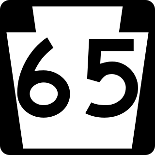
Pennsylvania Route 65 is a major 51-mile-long (82 km) state highway located in western Pennsylvania, United States. The route, traveling north–south from the Interstate 279/U.S. Route 19 Truck concurrency in Pittsburgh north to the PA 108/PA 168 concurrency in New Castle, connects downtown Pittsburgh to the northwestern portion of the Pittsburgh Metropolitan Area. PA 65 is similar in its purpose to PA 18 and PA 51, both of which run parallel to PA 65 at one point or another; however, the three routes pass through different cities for most of their respective alignments.

<span class="mw-page-title-main">Pennsylvania Route 51</span> State highway in Pennsylvania

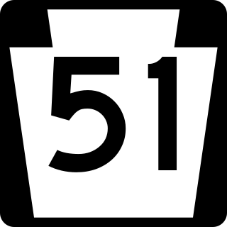
Pennsylvania Route 51 is a major state highway that is located in Western Pennsylvania in the United States. It runs for 89 miles (143 km) from Uniontown to the Ohio state line near Darlington, where it connects with Ohio State Route 14.

<span class="mw-page-title-main">U.S. Route 19 Truck (Pittsburgh)</span> Highway in Pennsylvania

U.S. Route 19 Truck is a truck route of US 19 located in Western Pennsylvania in Greater Pittsburgh that has a length of 19.4 miles (31.2 km). It is a loop off US 19; the southern terminus located in Mt. Lebanon and the northern terminus in McCandless, connecting to US 19 at both ends. The route is notable for a large, unorthodox interchange with the Penn–Lincoln Parkway just west of the Fort Pitt Tunnel, where the route joins the parkway and forms several wrong-way concurrencies, including one with its own opposing directions. North of Pittsburgh, US 19 Truck is called McKnight Road and south of Pittsburgh it carries West Liberty Avenue and Washington Road.

References

  1. 1 2 "PGHSNAP 2010 Raw Census Data by Neighborhood". Pittsburgh Department of City Planning PGHSNAP Utility. 2012. Retrieved June 28, 2013.{{cite news}}: External link in |publisher= (help)
  2. "PGHSNAP - Neighborhoods: All Raw Data".
  3. "Census:Pittsburgh" (PDF). Archived from the original (PDF) on August 10, 2007. Retrieved September 2, 2012.[ better source needed ]
  4. "Pittsburgh Census Tracts". pitt.libguides.com. Retrieved January 2, 2018.
  5. Bloom, Albert W. (January 14, 1953). "Pittsburgh today made up of many villages". Pittsburgh Post-Gazette. p. 23. Retrieved December 2, 2015.
  6. "Neighborhood Business District Program – URA". ura.org.
  7. "Phase I Airport Busway/Wabash HOV, Allegheny County, Pennsylvania: Environmental Impact Statement". January 3, 1994 via Google Books.
  8. "West End railroad underpass that snarled traffic to come down". Pittsburgh Post-Gazette.
  9. Schmitz, Jon (June 7, 2011). "West End Circle Redesign Wins Award". Pittsburgh Post-Gazette . Retrieved October 13, 2011.