Downtown Pittsburgh

Last updated

Downtown
Central Business District; Golden Triangle
Downtown Pittsburgh seen from Mt. Washington.jpg
Downtown Pittsburgh as seen from Mount Washington
Pgh locator central business district.svg
Location of Downtown Pittsburgh in Pittsburgh
Coordinates: 40°26′28″N80°00′00″W / 40.44111°N 80.00000°W / 40.44111; -80.00000
CountryUnited States
State Pennsylvania
County Allegheny County
City Pittsburgh
Area
  Total0.64 sq mi (1.7 km2)
Population
 (2020) [1]
  Total5,477 [2]

Downtown Pittsburgh, colloquially referred to as the Golden Triangle, and officially the Central Business District, [1] is the urban downtown center of Pittsburgh, Pennsylvania, United States. It is located at the confluence of the Allegheny River and the Monongahela River whose joining forms the Ohio River. The triangle is bounded by the two rivers.

Contents

The area features offices for major corporations such as PNC Bank, U.S. Steel, PPG, Bank of New York Mellon, Heinz, Federated Investors, and Alcoa. It is where the fortunes of such industrial barons as Andrew Carnegie, Henry Clay Frick, Henry J. Heinz, Andrew Mellon and George Westinghouse were made. It contains the site where the French fort, Fort Duquesne, once stood.

Historical population
YearPop.±%
1940 7,864    
1950 7,517−4.4%
1960 2,211−70.6%
1970 3,679+66.4%
1980 3,220−12.5%
1990 3,785+17.5%
2000 2,721−28.1%
2010 3,629+33.4%
2020 5,477+50.9%
[3] [4] [ better source needed ]
Source: University of Pittsburgh [5]

Location

The Central Business District is bounded by the Monongahela River to the south, the Allegheny River to the north, and I-579 (Crosstown Boulevard) to the east. An expanded definition of Downtown may include the adjacent neighborhoods of Uptown/The Bluff, the Strip District, the North Shore, and the South Shore.

Transportation

The Smithfield Street Bridge SmithfieldBridge-Szmurlo.jpg
The Smithfield Street Bridge
Famed mural on the 300 Sixth Street building Muralof300SixthStreetBuilding.jpg
Famed mural on the 300 Sixth Street building

Public transportation

Downtown is served by the Port Authority's light rail subway system (known locally as the "T"), an extensive bus network, and two inclines (Duquesne Incline and Monongahela Incline). The Downtown portion of the subway has the following stations:

T Stations

Downtown is also home to the Pittsburgh Amtrak train station connecting Pittsburgh with New York City, Philadelphia, and Washington, D.C. to the east and Cleveland and Chicago to the west. Greyhound's Pittsburgh bus terminal is located across Liberty Avenue from the Amtrak Station, in the Grant Street Transportation Center building.

Highways

Major roadways serving Downtown from the suburbs include the "Parkway East" (I-376) from Monroeville, the "Parkway West" (I-376) from the airport area, and the "Parkway North" (I-279) from the North Hills, and (I-579) in Downtown Pittsburgh. Other important roadways are Pennsylvania Route 28, Pennsylvania Route 51, Pennsylvania Route 65, and U.S. Route 19.

Three major entrances to the city are via tunnels: the Fort Pitt Tunnel and Squirrel Hill Tunnel on I-376 and the Liberty Tunnels. The New York Times once called Pittsburgh "the only city with an entrance," [6] specifically referring to the view of Downtown that explodes upon drivers immediately upon exiting the Fort Pitt Tunnel. Also traveling I-279 south and I-376, the city "explodes into view" when coming around a turn in the highway.

Local streets

Wood Street Woodstreetpittsburgh1.jpg
Wood Street

Downtown surface streets are based on two distinct grid systems that parallel the Allegheny and Monongahela rivers. [7] These two grids intersect along Liberty Avenue, creating many unusual street intersections. Furthermore, the Allegheny grid contains numbered streets, while the Monongahela grid contains numbered avenues. And, in fact, there are cases where these numbered roadways intersect, creating some confusion (i.e. the intersection of Liberty Avenue and 7th Street/6th Avenue). This unusual grid pattern leads to Pittsburghers giving directions in the terms of landmarks, rather than turn-by-turn directions. [7]

Bridges

At least seventeen of Pittsburgh's bridges are visible in this aerial photo Pittsburgh, Pennsylvania.jpg
At least seventeen of Pittsburgh's bridges are visible in this aerial photo

Pittsburgh is nicknamed "The City of Bridges". In Downtown, there are 10 bridges (listed below) connecting to points north and south. The expanded definition of Downtown (including the aforementioned surrounding neighborhoods) includes 18 bridges. Citywide there are 446 bridges. In Allegheny County the number exceeds 2,200.

Downtown Bridges

Sixth Avenue in Downtown Pittsburgh Dwntwnpgh27.jpg
Sixth Avenue in Downtown Pittsburgh

Bridges of Expanded Downtown

Downtown districts

Downtown contains a wealth of historic, cultural, and entertainment sites. While most people still consider the entire Downtown as one neighborhood, there are several significant subdistricts within the Golden Triangle.

Economy

Pittsburgh's number of jobs is generally stable. Jobs located within the City of Pittsburgh, 1991-2007.jpg
Pittsburgh's number of jobs is generally stable.

Downtown Pittsburgh retains substantial economic influence, ranking at 25th in the nation for jobs within the urban core and 6th in job density. [9]

University of Pittsburgh economist Christopher Briem notes that the level of employment in the city has remained largely constant for the past 50 years: "[the] time series of jobs located in the City proper are about as stable as any economic metric in the region, or in any other Northeastern US urban core, over many decades. In 1958, [there were] 294,000 jobs located in the city properThose numbers are virtually identical today which tells me there is a certain limit to how many jobs can efficiently be located in what are some relatively (very) constrained areas." [10] [ better source needed ] These numbers reflect employment in the city as a whole, not just the central business district; but the central business district has the highest density of employment of any Pittsburgh neighborhood.

Pittsburgh has long been a headquarters city, with numerous national and global corporations calling the Golden Triangle home. Currently, Downtown is still home to a large number of Fortune 500 companies (7 in the metro area, 5 of which are in the city in 2022, which ranks Pittsburgh high nationally in Fortune 500 headquarters):

– co-headquartered in PPG Place

– headquartered in the Tower at PNC Plaza

– headquartered in PPG Place

– headquartered at Station Square

– headquartered at the US Steel Tower

Downtown is also home to GNC, Dollar Bank, Equitable Resources, Duquesne Light, Federated Investors and Highmark as well as the regional headquarters for Citizens Bank, Ariba, and Dominion Resources. Regional healthcare giant UPMC has its corporate headquarters in the US Steel Tower.

Major buildings

The sweeping roofline of the David L. Lawrence Convention Center on the Allegheny River David L. Lawrence Convention Center, Pittsburgh, from a bridge 2006.jpg
The sweeping roofline of the David L. Lawrence Convention Center on the Allegheny River

Parks and plazas

Market Square Market Square Pittsburgh.JPG
Market Square

Downtown is home to numerous parks, large and small:

Educational facilities

While Pittsburgh's Oakland neighborhood is known as the educational center of the city, Downtown is home to several higher education institutions as well as a branch of the city's Carnegie Library system and a Pittsburgh Public Schools 6–12 school:

Residential areas

Downtown has several condos, including Gateway Towers and Chatham Place dating to the 1960s [11] and more modern structures as well. There are over 5,000 apartment and condo units in Greater Downtown Pittsburgh.

Surrounding neighborhoods

See also

Related Research Articles

<span class="mw-page-title-main">Allegheny County, Pennsylvania</span> County in Pennsylvania, United States

Allegheny County is a county in Pennsylvania, United States. It is located in Southwestern Pennsylvania. As of the 2020 census, the population was 1,250,578, making it the state's second-most populous county, after Philadelphia County. Its county seat and most populous city is Pittsburgh, Pennsylvania's second most populous city. Allegheny County is part of the Pittsburgh, PA metropolitan statistical area and the Pittsburgh media market.

<span class="mw-page-title-main">Interstate 579</span> Highway in Pennsylvania

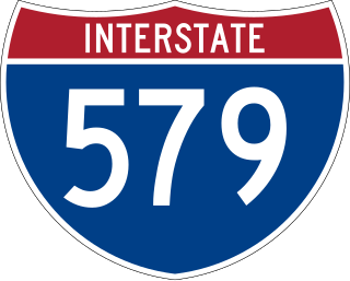
Interstate 579 (I-579) is a north–south Interstate Highway entirely within Pittsburgh, Pennsylvania. The highway is 2.73 miles (4.39 km) long. I-579 is also known as the Crosstown Boulevard since it crosses the backside of Downtown Pittsburgh.

<span class="mw-page-title-main">Allegheny, Pennsylvania</span> Former city in Pennsylvania, United States

Allegheny City was a municipality that existed in the U.S. state of Pennsylvania from 1788 until it was annexed by Pittsburgh in 1907. It was located north across the Allegheny River from downtown Pittsburgh, with its southwest border formed by the Ohio River, and is known today as the North Side. The city's waterfront district, along the Allegheny and Ohio rivers, became Pittsburgh's North Shore neighborhood.

<span class="mw-page-title-main">Highland Park (Pittsburgh neighborhood)</span> Neighborhood of Pittsburgh in Allegheny County, Pennsylvania, United States

Highland Park is a neighborhood in the northeastern part of Pittsburgh, Pennsylvania. Highland Park, the neighborhood, fully encompasses the park with the same name.

<span class="mw-page-title-main">Allegheny County belt system</span> Allegheny County belt system

The Allegheny County Belt System color codes various county roads to form a unique system of routes in Allegheny County, Pennsylvania, and around the city of Pittsburgh.

<span class="mw-page-title-main">North Shore (Pittsburgh)</span> Neighborhood of Pittsburgh in Allegheny County, Pennsylvania, United States

North Shore is a neighborhood in Pittsburgh's North Side. Its zip code is 15212.

<span class="mw-page-title-main">West End (Pittsburgh)</span> Neighborhood of Pittsburgh in Allegheny County, Pennsylvania, United States

West End Village is a neighborhood in Pittsburgh, Pennsylvania's west city area. It has a zip code of 15220, and has representation on Pittsburgh City Council by the council member for District 2.

<span class="mw-page-title-main">Fort Duquesne Bridge</span> Bridge in Pittsburgh, Pennsylvania

The Fort Duquesne Bridge is a steel bowstring arch bridge that spans the Allegheny River in Pittsburgh, Pennsylvania. It was colloquially referred to as "The Bridge to Nowhere".

<span class="mw-page-title-main">Transportation in Pittsburgh</span> Transportation in Pittsburgh, Pennsylvania, United States

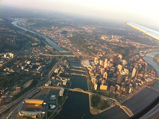
Transportation in Pittsburgh, Pennsylvania is different than in many other major American cities. A large metropolitan area that is surrounded by rivers and hills, Pittsburgh has an infrastructure system that has been built out over the years to include roads, tunnels, bridges, railroads, inclines, bike paths, and stairways; however, the hills and rivers still form many barriers to transportation within the city.

<span class="mw-page-title-main">Boulevard of the Allies</span> Major road in Pittsburgh, US

The Boulevard of the Allies is a mostly four-lane road in the U.S. state of Pennsylvania, connecting Downtown Pittsburgh with the Oakland neighborhood of the city. Because of its lengthy name, locals sometimes refer to it as simply "The Boulevard".

<span class="mw-page-title-main">Pittsburgh Light Rail</span> Light rail system in Pittsburgh, Pennsylvania

The Pittsburgh Light Rail is a 26.2-mile (42.2 km) light rail system in Pittsburgh, Pennsylvania, and surrounding suburbs. It operates as a deep-level subway in Downtown Pittsburgh, but runs mostly at-grade in the suburbs south of the city. The system is largely linear in a north-south direction, with one terminus near Pittsburgh's central business district and two termini in the South Hills. The system is owned and operated by Pittsburgh Regional Transit. The T is one of the surviving first-generation streetcar systems in North America, with the oldest portions of the network dating back to 1903 and the Pittsburgh Railways. It is also one of only three light rail systems in the United States that continues to use the broad 5 ft 2+12 in Pennsylvania Trolley Gauge on its lines instead of the 4 ft 8+12 instandard gauge. In 2022, the system had a ridership of 2,429,500.

<span class="mw-page-title-main">Pennsylvania Route 885</span> State highway in Allegheny County, Pennsylvania, US

Pennsylvania Route 885 is a 14.1 mi (22.69 km) long north–south state highway in the U.S. state of Pennsylvania. It runs from Pennsylvania Route 837 in Clairton north to Interstate 579 in Pittsburgh. The route is entirely within Allegheny County and serves as a connector between the city of Pittsburgh and its southern suburbs.

<span class="mw-page-title-main">Pennsylvania Route 837</span> State highway in Washington and Allegheny counties in Pennsylvania, US

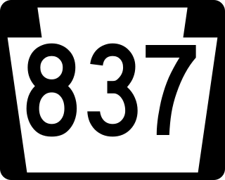
Pennsylvania Route 837 is a state route located in western Pennsylvania. The southern terminus of the route is at Pennsylvania Route 88 in the Carroll Township hamlet of Wickerham Manor. The northern terminus is at U.S. Route 19 and PA 51 near downtown Pittsburgh at the junction of the Ohio, Allegheny and Monongahela rivers. The highway parallels the Monongahela River for all of its route with the exceptions of its extreme north and south ends. Popular amusement park Kennywood is located along this route.

<span class="mw-page-title-main">Red Line (Pittsburgh)</span>

The Red Line is a line on the Pittsburgh Light Rail system that runs between South Hills Village and Downtown Pittsburgh via the Beechview neighborhood. The companion route, the Blue Line, branches off north of Martin Villa – which closed in 2012 – and runs through Overbrook. In March 2007, the closure of the Palm Garden Bridge for refurbishment suspended the Red Line for five months; it resumed service in September.

<span class="mw-page-title-main">Steel Plaza station</span> Light rail station in Pittsburgh, PA

Steel Plaza station is a station on the Pittsburgh Regional Transit's light rail network, located in Pittsburgh, Pennsylvania. It serves the city's Downtown district and is located at the intersection of Grant Street and Oliver Avenue. The station consists of an outbound (southbound) side platform and an inbound island platform, with one track for trains to Wood Street and the other for a disused branch line to Union Station. The station has rights to 4.25 acres underground Mellon Green and is accessible by means of a tunnel that connects BNY Mellon Center and the US Steel Tower. It is also the closest station to PPG Paints Arena and the primary station used for the Pittsburgh Penguins' home games.

<span class="mw-page-title-main">U.S. Route 19 Truck (Pittsburgh)</span> Highway in Pennsylvania

U.S. Route 19 Truck is a truck route of US 19 located in Western Pennsylvania in Greater Pittsburgh that has a length of 19.4 miles (31.2 km). It is a loop off US 19; the southern terminus located in Mt. Lebanon and the northern terminus in McCandless, connecting to US 19 at both ends. The route is notable for a large, unorthodox interchange with the Penn–Lincoln Parkway just west of the Fort Pitt Tunnel, where the route joins the parkway and forms several wrong-way concurrencies, including one with its own opposing directions. North of Pittsburgh, US 19 Truck is called McKnight Road and south of Pittsburgh it carries West Liberty Avenue and Washington Road.

<span class="mw-page-title-main">Point Bridge (Pittsburgh)</span> Bridge in Pittsburgh, Pennsylvania

The Point Bridge was a steel cantilever truss bridge that spanned the Monongahela River in Pittsburgh, Pennsylvania.

The following is a timeline of the history of the city of Pittsburgh, Pennsylvania, US.

References

  1. 1 2 3 "PGHSNAP 2010 Raw Census Data by Neighborhood". PGHSNAP Utility. Pittsburgh Department of City Planning. 2012. Retrieved June 21, 2013.
  2. "State of Downtown - Downtown Pittsburgh" (PDF). Downtown Pittsburgh. Archived from the original (PDF) on December 22, 2018. Retrieved April 30, 2018.
  3. "PGHSNAP - Neighborhoods: All Raw Data". google.com. Retrieved April 30, 2018.
  4. "Census:Pittsburgh" (PDF). Archived from the original (PDF) on August 10, 2007. Retrieved September 2, 2012.
  5. "Pittsburgh Census Tracts". pitt.libguides.com. Archived from the original on January 3, 2018. Retrieved January 2, 2018.
  6. "Top Ten Reasons to Visit Pittsburgh". Archived from the original on March 3, 2001. Retrieved June 28, 2007.
  7. 1 2 Conti, John (January 22, 2012). "How a municipality is designed can create elegance or chaos". Pittsburgh Tribune Review . Archived from the original on January 31, 2013. Retrieved January 22, 2012.
  8. "National Register Information System". National Register of Historic Places . National Park Service. March 13, 2009.
  9. Miller, Harold (August 3, 2008). "Regional Insights: Pittsburgh is a national player in jobs per square mile but needs more population". Pittsburgh Post-Gazette . Archived from the original on August 17, 2008. Retrieved August 6, 2008.
  10. Briem, Christopher (August 5, 2011). "hold em like they do in Texas plays". Nullspace. Archived from the original on March 28, 2012. Retrieved August 6, 2011.
  11. "The Pittsburgh Press - Google News Archive Search". news.google.com.

Further reading