Cheshire West and Chester

Last updated

Cheshire West and Chester
Skyline of Chester with the Cathedral.jpg
Chester, the county town of Cheshire and the largest settlement in Cheshire West and Chester
Cheshire West and Chester UK locator map.svg
Cheshire West and Chester shown within Cheshire
Coordinates: 53°12′47″N2°54′07″W / 53.213°N 2.902°W / 53.213; -2.902
Sovereign state United Kingdom
Country England
Region North West
Ceremonial county Cheshire
Incorporated1 April 2009
Government
[1]
  Type Unitary authority with leader and cabinet
  Body Cheshire West and Chester Council
   Control Labour
   Leader Louise Gittins (L)
  ChairmanRobert Bisset
   Chief Executive Delyth Curtis
   House of Commons
Area
[2]
  Total363 sq mi (941 km2)
  Land360 sq mi (920 km2)
  Rank 31st
Population
 (2022) [3]
  Total361,694
  Rank 24th
  Density1,020/sq mi (393/km2)
Ethnicity (2021)
[4]
   Ethnic groups
List
Religion (2021)
[4]
   Religion
List
Time zone UTC+0 (GMT)
  Summer (DST) UTC+1 (BST)
Postcode areas
  • CH1–4
  • CH33–34
  • CH64–66
  • CW6–10
  • SY14
  • WA4–6
Dialling codes
  • 01244
  • 01270
  • 01477
  • 0151
  • 01565
  • 01606
  • 01829
  • 01925
  • 01928
  • 01948
ISO 3166 code GB-CHW
GSS code E06000050
ITL code TLD63
GVA 2021 estimate [5]
 Total £11.7 billion
 Per capita£32,846
GDP (nominal)2021 estimate [5]
 Total£13.1 billion
 Per capita£36,518
Website cheshirewestandchester.gov.uk

Cheshire West and Chester is a local government district with borough status in Cheshire, England. It was established on 1 April 2009 as part of the 2009 local government changes, by virtue of an order under the Local Government and Public Involvement in Health Act 2007. [6] It superseded the boroughs of Ellesmere Port and Neston, Vale Royal and the City of Chester; its council is a unitary authority, having also assumed the functions and responsibilities of the former Cheshire County Council within its area. The remainder of ceremonial Cheshire is composed of Cheshire East, Halton and Warrington. Cheshire West and Chester has three key urban areas: Chester, Ellesmere Port and Northwich/Winsford.

Contents

The decision to create the Cheshire West and Chester unitary authority was announced on 25 July 2007 following a consultation period, in which a proposal to create a single Cheshire unitary authority was rejected. [7]

Governance

The council is a unitary authority, being a district council which also performs the functions of a county council. Full council meetings are held at Wyvern House in Winsford and the council has its main offices at The Portal in Ellesmere Port. [8] [9]

Subdivisions

The borough is divided into forty-six wards, [10] [11] listed below in alphabetical order.

There are ninety-seven parish councils in the borough, [12] [13] despite there being a total of 166 civil parishes before a community governance review was undertaken by the borough council in 2014 [14] under section 82 of the Local Government and Public Involvement in Health Act 2007. [15]

Notes
  1. ^
    3: Civil parishes highlighted in bold have unilaterally declared town status under section 12A of the Local Government Act 1972.

Members of Parliament

Constituency Member of Parliament Political party Year first electedNotesWebsiteParliamentary profile
City of Chester Chris Matheson Labour Party 2015 Shadow Minister (Digital, Culture, Media and Sport) Website Profile Official portrait of Christian Matheson MP crop 2.jpg
Eddisbury Edward Timpson Conservative Party 2019
[Note 4]
Website Profile Official portrait of Edward Timpson MP crop 2.jpg
Ellesmere Port and Neston Justin Madders Labour Party 2015 Shadow Minister (Health and Social Care) Website Profile Official portrait of Justin Madders MP crop 2.jpg
Tatton Esther McVey Conservative Party 2017
[Note 5]
Website Profile Official portrait of Esther McVey crop 2.jpg
Weaver Vale Mike Amesbury Labour Party 2017 Shadow Minister (Housing, Communities and Local Government) Website Profile Official portrait of Mike Amesbury MP crop 2.jpg
MPs in Cheshire West and Chester, 2005 onwards [Note 6]
Election year → 2005 2010 [Note 7] 2015 2017 2019
City of Chester Christine Russell Stephen Mosley Chris Matheson
Eddisbury Stephen O'Brien Antoinette Sandbach Edward Timpson
Ellesmere Port and Neston Andrew Miller Justin Madders
Tatton George Osborne Esther McVey
Weaver Vale Mike Hall Graham Evans Mike Amesbury

Current MPs are highlighted in bold.

Notes
  1. ^
    4: Previously elected to parliament in 2008 for the Crewe and Nantwich constituency.
  2. ^
    5: Previously elected to parliament in 2010 for the Wirral West constituency.
  3. ^
    6: From the last election before the borough of Cheshire West and Chester was established.
  4. ^
    7: From the first election following the most recent periodic review of Westminster constituencies, where boundary changes affected the constituencies.
Last electionBy-electionsNext election
2019 2024

Demography

Ethnicity

Ethnicity in Cheshire West and Chester (2021) [4]
EthnicityPercent(%)
White
95.3%
Asian
2.0%
Mixed
1.5%
Black
0.6%
Other
0.6%

In line with nearly every local government district in England and Wales, the majority of the population describe themselves as 'white'. The exact figure – 95.3% – is comparable with metropolitan counties such as Merseyside, non-metropolitan counties such as Cumbria and principal areas throughout Wales. This would suggest that the figure is not a significant outlier nationwide.

The next largest ethnic group in the borough is Asian, who along with other ethnic minorities are supported by the Cheshire Asian & Minority Communities Council, a registered charity headquartered in Chester.

Religion

Religion in Cheshire West and Chester (2021) [4]
ReligionPercent(%)
Christian
54.5%
No religion
37.8%
Undeclared
5.5%
Muslim
1.0%
Hindu
0.4%
Other
0.3%
Buddhist
0.3%
Jewish
0.1%
Sikh
0.1%

The main religion in Cheshire West and Chester is Christianity, with a percentage figure above the average for England (46.3%, 2021). [18] The single largest church is the Church of England, with the borough being served by the Chester Archdeaconry, with six deaneries and an average of twenty parish churches in each deanery. Roman Catholicism also has a significant presence across the borough, with all its churches located in the Diocese of Shrewsbury.

Methodist churches in the borough form groups averaging ten, known as 'circuits' (the four in Cheshire West and Chester are all part of the Chester and Stoke-on-Trent District). More marginal churches include Assemblies of God, Baptist Union, Elim Pentecostal, United Reformed and the English Presbyterian Church of Wales in Chester.

Aside from churches, there are two mosques in Cheshire West and Chester – one each in Chester and Ellesmere Port – which were subjected to property theft [19] and racially aggravated disorder [20] respectively in 2014.

Geography

Neighbouring council areas
Local authorityIn relation to the district
City of Liverpool North (over the river)
Halton North
Warrington North east
Cheshire East East
Newcastle-under-Lyme South
Wrexham South west
Flintshire West
Wirral North west

Local nature reserves

Cheshire West and Chester Council maintains six Local Nature Reserves: Burton Mill Wood, Helsby Quarry, Marshall's Arm, Rivacre Valley, Stanney Wood, and Whitby Park. [21]

Transport

Air

There are no passenger airports in the borough (a grass airfield exists in Little Budworth), with the nearest being Liverpool and Manchester which licensed vehicles provide transport to. Airbus' fleet of A300-600ST Beluga transporter aircraft are based at Hawarden Airport in neighbouring Flintshire, adjacent to their wing manufacturing facility.

Cycling

National routes which pass through the borough include NCR5, NCR45 (Mercian Way), NCR56, NCR562, NCR563, NCR568 and NCR573. Regional routes include 70 (Cheshire Cycleway) and 71.

Three disused railways in the borough have been converted to off-road cycleways, including:

The Shropshire Union Canal towpath between Waverton and the National Waterways Museum is paved with asphalt and is a shared-use route between cyclists and pedestrians, for a distance of 12.5 miles. Between Tarvin Bridge and Blacon Avenue, it is also lit.

In 2009, Chester was awarded the status of 'Cycling Town' by Cycling England. To reflect this, a series of colour-coded signposted routes around the city were devised in 2012. [22] The total length of new signposted routes created by the project was thirty-eight miles, bringing the overall total in the borough to 312.5. The total funding received from the cycling town project, which ended in 2011 when Cycling England was disbanded, was £4.4 million. [23] A similar network of over thirty miles of cycle routes branded the Ellesmere Port Grenway has been proposed by the town's development board. [24]

Park and Ride

Chester has four park and ride sites located adjacent to radial routes on the city's outskirts (Boughton Heath, Sealand Road, Upton and Wrexham Road) running on two lines which intersect at Chester Bus Interchange. A fifth site is proposed near Hoole Village.

Chester Park and Ride services
RouteTerminusIntermediate stopChester city centreIntermediate stopTerminus
Blue (PR1) Upton (Zoo) Countess of Chester Hospital Delamere StreetChester Bus InterchangeForegate StreetPepper StreetGrosvenor Road Wrexham Road
Green (PR2) Sealand RoadSealand Road (Greyhound Park)Canal Street Boughton Boughton Heath

Hooton station is designated as a park and ride facility for railway services on the Wirral Line, it contains a 418-space car park. [25]

Rail

Chester railway station Chester railway station 1.JPG
Chester railway station

Chester is the hub of the railway network in the borough, with around 4.7 million passengers annually. [26] Passenger numbers doubled to this figure in the ten years to 2015, making the station the eighth-busiest in North West England. [27] Railway lines (and their associated franchise(s)) in the borough – not necessarily connecting to Chester – include:

Current and proposed improvements

The sections of railway between Chester – Stockport and Chester – Warrington Bank Quay are proposed for electrification during the period 2019–2024. [28]

The Crewe North Rolling Stock Depot serving High Speed Two is proposed to be built in the civil parish of Stanthorne and Wimboldsley. The line itself enters the borough in that location and leaves it again near the A556/A559 junction at Lostock Gralam. [29]

Road

A556 west of Northwich looking towards Sandiway. A556, Chester Road, Sandiway - geograph.org.uk - 192607.jpg
A556 west of Northwich looking towards Sandiway.

Motorways and primary routes in the borough which are maintained by National Highways (trunk roads de jure) include the M6, M53, M56, A55, A483, A494, A550 and a short section of the A41 in Hooton. Other primary routes which are maintained by the council (principal roads de jure) include the A41, A49, A51, A54, A56, A483, A530, A533, A534, A556, A5115, A5116, A5117 and A5268.

Chester and Ellesmere Port – both primary route destinations – form the hub of the road network in Cheshire West and Chester, with routes of national importance carrying traffic in all directions to locations including Flintshire, Halton, Wirral and Wrexham.

European Route E05 is routed via the M6, carrying international traffic between Scotland, North West England, the West Midlands and France via Southampton. European route E22 is routed via the A494 and M56, carrying international traffic between Ireland (the route in fact begins at the Port of Holyhead), North Wales, North West England, Yorkshire and the Netherlands. Both routes meet at Lymm Interchange, which lies in neighbouring Cheshire East.

Three Roman roads exist in Cheshire West and Chester, Two originating in Chester ( Deva Victrix ) and running to Northwich ( Condate ) and Whitchurch ( Mediolanum ) respectively. The Roman road of kings street in Northwich which runs from Middlewich to Warrington.

The section of the A51 between its western terminus and the B5132 was named as one of the most congested roads in the United Kingdom by INRIX in August 2015. [30]

Three local MPsGraham Evans, Justin Madders and Chris Matheson – raised safety concerns about the M56 between J12 and J14 in parliament after more than one hundred-and-sixty incidents were recorded since 2011. In response, Andrew Jones, the Parliamentary Under Secretary of State for Transport, confirmed that an upgrade to smart motorway will only take place after 2020. [31] [32]

Water

Navigable waterways in the borough include the Manchester Ship Canal, Shropshire Union Canal, Trent and Mersey Canal and the Weaver Navigation, the latter two being connected together by the Anderton Boat Lift near Northwich, the only caisson lift lock in the United Kingdom.

Places of interest

Tourist attractions

Key
AP Icon.svg Abbey/Priory/Cathedral
UKAL icon.svg Accessible open space
Themepark uk icon.png Amusement/Theme Park
CL icon.svg Castle
Country parks.svg Country Park
EH icon.svg English Heritage
Forestry Commission
HR icon.svg Heritage railway
HH icon.svg Historic House
AP Icon.svg Places of Worship
Museum icon.svg
Museum icon (red).svg
Museum (free/not free)
NTE icon.svg National Trust
Drama-icon.svg Theatre
Zoo icon.jpg Zoo

Media

Television

The area is served by BBC North West and ITV Granada with television signals received from the Winter Hill TV transmitter. [33]

Radio

Radio stations for the area are: [34]

Sport

Football

Deva Stadium Deva Stadium.jpg
Deva Stadium

Chester FC are the highest ranked club in the area and compete in the National League North (the sixth tier of English football. Northwich has four semi-professional teams – Barnton, Northwich Victoria, Witton Albion and 1874 Northwich – all of whom play in regional leagues. Winsford is also represented in the non-league pyramid by Winsford United, and Ellesmere Port by Vauxhall Motors FC – the former works team of the Vauxhall Ellesmere Port assembly plant.

Below level ten of the English pyramid are county-wide amateur leagues, with two covering the geographic area of the borough – the Cheshire Association Football League and West Cheshire Association Football League. Although several clubs are members of the former, many more compete in the latter. Below that is the Chester & Wirral Football League, and also the Mid-Cheshire district leagues who cater for the areas of knutsford, Northwich, Middlewich and Winsford where teams representing neighbourhoods/villages and/or pubs/social clubs ('pub teams') compete.

The largest football stadium in Cheshire West and Chester is the Deva Stadium, home to Chester FC, although the ground famously straddles the England-Wales border.

Twin towns

Whilst the borough per se does not have any twinning agreements, several of its settlements have agreements predating its creation in 2009, listed below:

Settlement(s)Twin town(s)
Barrow
Littleton
Flag of France.svg Aubignan
Chester Flag of France.svg Sens
Flag of Germany.svg Lörrach
Flag of Italy.svg Senigallia
Ellesmere Port Flag of Germany.svg Reutlingen
Malpas Flag of France.svg Questembert
Northwich Flag of France.svg Dole
Flag of Ireland.svg Carlow
Tarporley Flag of France.svg Bohars
Upton-by-Chester Flag of France.svg Arradon
Winsford Flag of France.svg Deuil-la-Barre

See also

Related Research Articles

<span class="mw-page-title-main">Cheshire</span> County of England

Cheshire is a ceremonial county in North West England. It is bordered by Merseyside to the north-west, Greater Manchester to the north-east, Derbyshire to the east, Staffordshire to the south-east, and Shropshire to the south; to the west it is bordered by the Welsh counties of Flintshire and Wrexham, and has a short coastline on the Dee Estuary. Warrington is the largest settlement, and the city of Chester is the county town.

<span class="mw-page-title-main">Merseyside</span> County of England

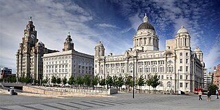
Merseyside is a ceremonial and metropolitan county in North West England. It borders Lancashire to the north, Greater Manchester to the east, Cheshire to the south, the Welsh county of Flintshire across the Dee Estuary to the southwest, and the Irish Sea to the west. The largest settlement is the city of Liverpool.

<span class="mw-page-title-main">Frodsham</span> Town and civil parish in England

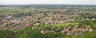
Frodsham is a market town, civil parish, and electoral ward in the unitary authority of Cheshire West and Chester and the ceremonial county of Cheshire, England. Its population in 2021 was 9,300. It is 16 miles (26 km) south of Liverpool and 28 miles (45 km) southwest of Manchester. The River Weaver runs to its northeast and on the west it overlooks the estuary of the River Mersey. The A56 road and the Chester–Manchester railway line pass through the town, and the M56 motorway passes to the northwest.

<span class="mw-page-title-main">Ellesmere Port</span> Town in Cheshire, England

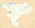
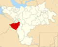
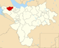
Ellesmere Port is a port town in the Cheshire West and Chester borough in Cheshire, England. Ellesmere Port is on the south eastern edge of the Wirral Peninsula, six miles north of Chester, on the bank of the Manchester Ship Canal. The town had a population of 61,090 in the 2011 census. Ellesmere Port also forms part of the wider Birkenhead urban area, which had a population of 325,264 in 2011.

<span class="mw-page-title-main">Neston</span> Market town and civil parish in Cheshire, England

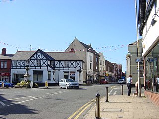
Neston is a market town and civil parish on the Wirral Peninsula, in Cheshire, England. It is part of the unitary authority of Cheshire West and Chester. The civil parish and wider suburban area includes Parkgate to the north west and Little Neston, Ness and part of Burton to the south.

<span class="mw-page-title-main">M53 motorway</span> Motorway in England

The M53 is an 18.9-mile (30.4 km) motorway in the Metropolitan Borough of Wirral, Merseyside and the borough of Cheshire West and Chester, Cheshire on the Wirral Peninsula in England. It is also referred to as the Mid Wirral Motorway. It runs between the Kingsway Tunnel, at Wallasey in the north, and the A55 at Chester.

Merseytravel is the passenger transport executive, responsible for the coordination of public transport in the Liverpool City Region in North West England. Merseytravel was established on 1 December 1969 as the Merseyside Passenger Transport Executive. From 1 April 2014, with the creation of the Liverpool City Region, Merseytravel expanded its area of operation from the metropolitan county of Merseyside to also include the Borough of Halton.

<span class="mw-page-title-main">Helsby railway station</span> Railway station in Cheshire, England

Helsby railway station serves the village of Helsby in Cheshire, England. It is recorded in the National Heritage List for England as a Grade II listed building.

<span class="mw-page-title-main">Wirral line</span> Commuter rail route in Merseyside, England

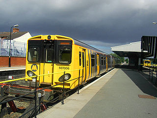
The Wirral line is one of two commuter rail routes operated by Merseyrail and centred on Merseyside, England, the other being the Northern line.

<span class="mw-page-title-main">Hooton railway station</span> Railway station on the Chester & Ellesmere Port branches of the Wirral line in England

Hooton railway station is situated in the south of the Wirral Peninsula, Cheshire, England. It lies on the Wirral Line 8 miles (13 km) north of Chester and 9+12 miles (15.3 km) south west of Liverpool Lime Street on the Merseyrail network, and is the junction of the branch from the Chester line to Ellesmere Port. It serves the villages of Hooton and Willaston.

<span class="mw-page-title-main">Birkenhead Woodside railway station</span> Former GWR & LNWR railway station in Birkenhead, Wirral, England

Birkenhead Woodside was a railway station located at Woodside, in Birkenhead, on the Wirral Peninsula, Cheshire. It served both local services within Cheshire and long-distance services to southern England, including London.

<span class="mw-page-title-main">Ellesmere Port railway station</span> Railway station on the Ellesmere Port branch of the Wirral line in England

Ellesmere Port railway station is located in the town of Ellesmere Port, Cheshire, England. The station was an intermediate through station on the Hooton–Helsby line. Now all passenger services terminate at the station from both directions. It is both a terminus of the Wirral Line, a commuter rail system operated by Merseyrail and of Northern Trains services to Warrington Bank Quay. Departures and arrivals of Merseyrail services are on platform 1 with departures and arrivals to Warrington Bank Quay on platform 2.

<span class="mw-page-title-main">Rock Ferry railway station</span> Railway station on the Chester & Ellesmere Port branches of the Wirral line in England

Rock Ferry railway station is situated in the Rock Ferry area of Birkenhead, Merseyside, England. The station lies 4.5 miles (7 km) south west of Liverpool Lime Street on the Chester and Ellesmere Port branches of the Wirral Line of the Merseyrail network. The station has an island platform with four platforms in total and four tracks.

<span class="mw-page-title-main">Overpool railway station</span> Railway station on the Ellesmere Port branch of the Wirral line in England

Overpool railway station was opened on 17 August 1988 and serves the central area of Ellesmere Port, Cheshire, England. It is situated on the Hooton–Helsby line and is served by the Wirral Line which is part of the Merseyrail network.

<span class="mw-page-title-main">Little Sutton railway station</span> Railway station on the Ellesmere Port branch of the Wirral line in England

Little Sutton railway station serves the village of Little Sutton, near Ellesmere Port, Cheshire, England. It is situated on the Hooton–Helsby line and is served by the Wirral Line which is part of the Merseyrail network. The station is recorded in the National Heritage List for England as a designated Grade II listed building. The station opened in 1863 as "Sutton" and was renamed Little Sutton in 1886. It became part of the Merseyrail network in 1994, when the branch from Hooton to Ellesmere Port was electrified by British Rail, and through train services to Liverpool via Birkenhead commenced.

<span class="mw-page-title-main">Hooton, Cheshire</span> Human settlement in England

Hooton is a suburban village and former civil parish on the Wirral Peninsula, within the unitary authority of Cheshire West and Chester and the ceremonial county of Cheshire, England. It was once a separate village but was incorporated into Ellesmere Port as the town expanded outwards during the twentieth century.

<span class="mw-page-title-main">Hooton–Helsby line</span>

The Hooton–Helsby line is a railway line in the north-west of England that runs from Hooton on the Chester–Birkenhead line to the village and junction station at Helsby where it joins the Chester–Warrington line.

<span class="mw-page-title-main">Ledsham, Cheshire</span> Village in England

Ledsham is a village and civil parish in the unitary authority of Cheshire West and Chester and the ceremonial county of Cheshire, England. The civil parish includes parts of the hamlets of Badger's Rake and Two Mills. It is located on the Wirral Peninsula, approximately 10 km (6.2 mi) to the north of the city of Chester and 6 km (3.7 mi) to the west of Ellesmere Port.

<span class="mw-page-title-main">Birkenhead Railway</span> Former railway company in the UK

The Birkenhead Railway was a railway company in North West England. It was incorporated as the Birkenhead, Lancashire and Cheshire Junction Railway (BL&CJR) in 1846 to build a line connecting the port of Birkenhead and the city of Chester with the manufacturing districts of Lancashire by making a junction near Warrington with the Grand Junction Railway. The BL&CJR took over the Chester and Birkenhead Railway in 1847, keeping its own name for the combined company until it shortened its name to the Birkenhead Railway in 1859. It was taken over jointly, on 1 January 1860, by the London and North Western Railway (LNWR) and the Great Western Railway (GWR). It remained a joint railway until nationalisation of the railways in 1948.

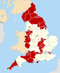
The ceremonial county of Cheshire, which comprises the unitary authorities of Cheshire East, Cheshire West and Chester, Halton and Warrington, has returned 11 MPs to the UK Parliament since 1997.

References

  1. "Councillors and committees". Cheshire West and Chester Council. Retrieved 15 December 2023.
  2. "Mid-Year Population Estimates, UK, June 2022". Office for National Statistics. 26 March 2024. Retrieved 3 May 2024.
  3. "Mid-Year Population Estimates, UK, June 2022". Office for National Statistics. 26 March 2024. Retrieved 3 May 2024.
  4. 1 2 3 4 UK Census (2021). "2021 Census Area Profile – Cheshire West and Chester Local Authority (E06000050)". Nomis. Office for National Statistics . Retrieved 15 December 2023.
  5. 1 2 Fenton, Trevor (25 April 2023). "Regional gross domestic product: local authorities". Office for National Statistics. Retrieved 13 December 2023.
  6. "The Cheshire (Structural Changes) Order 2008 – Article 4". legislation.gov.uk. Legislation.gov.uk. Archived from the original on 3 January 2011. Retrieved 15 January 2009.
  7. "County split into two authorities". BBC News. 25 July 2007. Archived from the original on 7 January 2009. Retrieved 25 July 2007.
  8. "Caldendar". Cheshire West and Chester Council. Retrieved 9 May 2024.
  9. "Registered office address". Cheshire West and Chester Council. Retrieved 9 May 2024.
  10. "Election 2011 Live Results". cheshirewestandchester.gov.uk. Cheshire West and Chester Council. 5 May 2011. Archived from the original on 11 May 2015. Retrieved 5 September 2015.
  11. "Your Councillors by Ward". cheshirewestandchester.gov.uk. Cheshire West and Chester Council. Retrieved 5 September 2015.
  12. "Town and parish councils". cheshirewestandchester.gov.uk. Cheshire West and Chester Council. Archived from the original on 22 May 2015. Retrieved 31 May 2015.
  13. "Parish and Town Councils in Cheshire" (PDF). chalc.org.uk. Cheshire Association of Local Councils. Archived from the original (PDF) on 31 May 2015. Retrieved 30 May 2015.
  14. "Community governance arrangements". cheshirewestandchester.gov.uk. Cheshire West and Chester Council. Archived from the original on 7 May 2015. Retrieved 6 June 2015.
  15. "Local Government and Public Involvement in Health Act 2007 – Section 82". legislation.gov.uk. Legislation.gov.uk. Retrieved 6 June 2015.
  16. "Register of Geographic Codes (November 2020) for the United Kingdom". geoportal.statistics.gov.uk. Office for National Statistics. 26 November 2020. Retrieved 21 December 2020.
  17. "Cheshire West and Chester unitary district". citypopulation.de. City Population. 27 June 2020. Retrieved 21 December 2020.
  18. UK Census (2021). "2021 Census Area Profile – England Country (E92000001)". Nomis. Office for National Statistics . Retrieved 10 August 2023.
  19. Flint, Rachel (28 July 2014). "Heartless thieves steal plants from mosque during Ramadan". Chester Chronicle . Archived from the original on 23 September 2015. Retrieved 28 July 2015.
  20. Flint, Rachel (23 October 2014). "Ellesmere Port man arrested after pig's head placed outside Islamic centre". Chester Chronicle . Archived from the original on 23 September 2015. Retrieved 28 July 2015.
  21. "Statutory Sites". Cheshire West and Chester council. Archived from the original on 3 January 2011. Retrieved 28 January 2011.
  22. "Complete Library of Free Chester Cycle Route Maps". chestercyclecity.org. Chester Cycling Campaign. Archived from the original on 29 May 2015. Retrieved 29 May 2015.
  23. "Cheshire West and Chester Council Cycling Strategy" (PDF). cheshirewestandchester.gov.uk. Cheshire West and Chester Council. Archived from the original (PDF) on 20 March 2017. Retrieved 19 March 2017.
  24. "Ellesmere Port Greenway". ellesmereportdevelopment.co.uk. Invest in Ellesmere Port. Archived from the original on 19 August 2017. Retrieved 19 August 2017.
  25. "Hooton". merseyrail.org. Merseyrail. Archived from the original on 25 August 2017. Retrieved 25 August 2017.
  26. "Estimates of station usage | Office of Rail and Road". orr.gov.uk. Retrieved 17 May 2019.
  27. "Chester Railway Station sees passenger numbers double in 10 years". chesterchronicle.co.uk. Chester Chronicle. 29 January 2016. Archived from the original on 30 January 2016. Retrieved 30 January 2016.
  28. "Electrification Task Force Final Report Revealed". railnorth.org. Rail North. 5 March 2015. Archived from the original on 14 June 2017. Retrieved 29 May 2015.
  29. "High Speed Two property schemes, July 2017, phase 2B: Crewe to Manchester, Volume 1: Cheshire East, Cheshire West and Chester key plan" (PDF). www.gov.uk . High Speed Two (HS2) Limited. 17 July 2017. Archived (PDF) from the original on 21 August 2017. Retrieved 20 August 2017.
  30. "Chester Road one of most congested outside London". The Standard. 25 August 2015. Archived from the original on 23 September 2015. Retrieved 3 September 2015.
  31. "Weaver Vale MP raises M56 issues in House of Commons". chesterchronicle.co.uk. Chester Chronicle. 18 November 2015. Archived from the original on 24 November 2015. Retrieved 5 December 2015.
  32. "M56 Smart Motorway won't happen". chesterchronicle.co.uk. Chester Chronicle. 21 November 2015. Archived from the original on 8 December 2015. Retrieved 5 December 2015.
  33. "Full Freeview on the Winter Hill (Bolton, England) transmitter". UK Free TV. May 2004. Retrieved 20 May 2024.
  34. "Radio Stations". Cheshire West and Chester Council. Retrieved 20 May 2024.