
Maricopa County is in the south-central part of the U.S. state of Arizona. As of the 2020 census the population was 4,420,568, or about 62% of the state's total, making it the fourth-most populous county in the United States and the most populous county in Arizona, and making Arizona one of the nation's most centralized states. The county seat is Phoenix, the state capital and fifth-most populous city in the United States.

Tuba City is an unincorporated town and census-designated place in Coconino County, Arizona, on the Navajo Nation, United States. It is the second-largest community in Coconino County. The population of the census-designated place (CDP) was 8,611 at the 2010 census.
Glendale is a city in Maricopa County, Arizona, United States. Located about nine miles northwest of the state capital Phoenix, Glendale is known for State Farm Stadium, which is the home of the Arizona Cardinals football team. The city also contains the Arrowhead Towne Center shopping mall. As of the 2020 census, Glendale had a population of 248,325.

New River is an unincorporated community and census-designated place (CDP) in Maricopa County, Arizona, United States. The population was 17,290 as of the 2020 census, up from 14,952 at the 2010 census.

Citrus Springs is a census-designated place (CDP) in Citrus County, Florida, United States. The population was 8,622 as of the 2010 census, up from 4,157 in 2000.
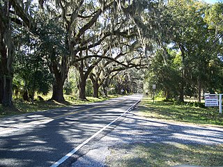
Floral City is a census-designated place (CDP) in Citrus County, Florida, United States. The population was 5,216 at the 2010 census. The community is home to the Floral City Heritage Hall Museum and hosts the Floral City Heritage Days the first weekend in December. The area has a history of phosphate mining and includes historic homes.

Homosassa Springs is an unincorporated community and census-designated place (CDP) in Citrus County, Florida, United States. The population was 14,283 as of 2020. Homosassa Springs is the principal city of the Homosassa Springs, Florida, Metropolitan Statistical Area.

Citrus Park is an unincorporated census-designated place in Hillsborough County, Florida, United States. The population was 28,178 at the 2020 census, up from 24,252 at the 2010 census.
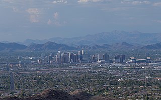
The Phoenix metropolitan area, also known as the Valley of the Sun, the Salt River Valley, metro Phoenix, or The Valley, is the largest metropolitan statistical area in the Southwestern United States, with its largest principal city being the city of Phoenix. It includes much of central Arizona. The United States Office of Management and Budget designates the area as the Phoenix–Mesa–Chandler Metropolitan Statistical Area (MSA), defining it as Maricopa and Pinal counties. It anchors the Arizona Sun Corridor megaregion along with the second-most populous metropolitan area in the state, the Tucson metropolitan area. The gross domestic product of the Phoenix metropolitan area was $255 billion in 2018, 16th highest amongst metro areas in the United States.

Tonopah is an unincorporated community and census-designated place (CDP) in western Maricopa County, Arizona, United States, 52 miles (84 km) west of downtown Phoenix off Interstate 10. The community is near the Palo Verde Nuclear Generating Station, the largest power producer in the country, nuclear or otherwise. As of the 2020 census, the population of Tonopah was 23, down from 60 at the 2010 census.
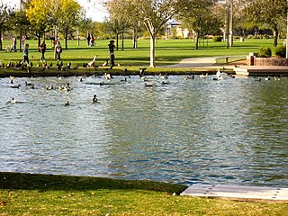
Anthem is a planned community partially located within Phoenix and partially located within New River, a census-designated place. The community is entirely located in Maricopa County, Arizona, United States, within the Phoenix Metropolitan Area. As of the 2020 census, the population of the Anthem was 23,190.

Wittmann is an unincorporated community and census-designated place (CDP) in Maricopa County, Arizona, United States. As of the 2020 census, it had a population of 684, down from 763 in 2010. It is located along U.S. Route 60 in the central part of Arizona, 35 miles (56 km) northwest of central Phoenix, and is part of the Phoenix metropolitan area, although just outside the urban portion.
Arizona's 3rd congressional district is a congressional district that includes most of southern, western, and downtown Phoenix, along with a portion of Glendale. It is currently represented by Democrat Ruben Gallego.

Morristown is an unincorporated community and census-designated place (CDP) in Maricopa County, Arizona, United States. It is 43 miles (69 km) northwest of Phoenix, at the junction of State Route 74 and U.S. Route 60. As of the 2020 census, it had a population of 186, down from 227 in 2010.

Komatke is a census-designated place in Maricopa County, Arizona, United States. The area currently comprising the census-designated place had a population of 1,013 at the 2020 census, up from 821 at the 2010 census. It is located within the Gila River Indian Community. Its name refers to the Sierra Estrella mountain range, which rises just to the southwest of Komatke.

Arizona is a landlocked state in the Southwestern region of the United States. Arizona is part of the Four Corners region with Utah to the north, Colorado to the northeast, and New Mexico to the east; its other neighboring states are Nevada to the northwest, California to the west and the Mexican states of Sonora and Baja California to the south and southwest. It is the 6th-largest and the 14th-most-populous of the 50 states. Its capital and largest city is Phoenix.
Roosevelt is a census-designated place (CDP) in Gila County, Arizona, United States. The population was 28 at the 2010 census.
Arizona's 9th congressional district was created as a result of the 2010 census. The first candidates ran in the 2012 House elections, and the first representative was seated for the 113th Congress in 2013. Formerly located in the Phoenix area, the 9th district has been in western Arizona since 2023.

Gila Crossing is a census-designated place (CDP) in Maricopa County, Arizona, United States, within the Gila River Indian Community south of Komatke. The population was 636 at the 2020 census.


