Colwyn, Pennsylvania

Last updated
Colwyn, Pennsylvania
Colwyn School PA.JPG
Colwyn Elementary School
Delaware County Pennsylvania incorporated and unincorporated areas Colwyn highlighted.svg
Location in Delaware County and the U.S. state of Pennsylvania.
USA Pennsylvania location map.svg
Red pog.svg
Colwyn
Location of Colwyn in Pennsylvania
Usa edcp location map.svg
Red pog.svg
Colwyn
Colwyn (the United States)
Coordinates: 39°54′47″N75°15′12″W / 39.91306°N 75.25333°W / 39.91306; -75.25333
CountryUnited States
StatePennsylvania
County Delaware
Government
  MayorMaurice J. Clark Sr.
Area
[1]
  Total0.26 sq mi (0.67 km2)
  Land0.26 sq mi (0.67 km2)
  Water0.00 sq mi (0.00 km2)
Elevation
59 ft (18 m)
Population
 (2020) [2]
  Total2,474
  Density9,589.15/sq mi (3,695.78/km2)
Time zone UTC-5 (EST)
  Summer (DST) UTC-4 (EDT)
Area code(s) 610
FIPS code 42-15432
Website www.colwynborough.com

Colwyn is a borough in Delaware County, Pennsylvania, United States. The population was 2,546 at the 2010 census. [3]

Contents

Geography

Colwyn is located along the eastern border of Delaware County at 39°54′47″N75°15′12″W / 39.91306°N 75.25333°W / 39.91306; -75.25333 (39.913062, -75.253409), [4] where Darby Creek and Cobbs Creek intersect. It is bordered to the north by the borough of Darby, to the west by Sharon Hill, to the south by Darby Township, and to the east by Philadelphia.

According to the U.S. Census Bureau, the borough has a total area of 0.26 square miles (0.67 km2), all land. [3]

Transportation

Fourth Street in Colwyn 2022-10-24 13 42 28 View south along South Fourth Street at Thatcher Avenue in Colwyn, Delaware County, Pennsylvania.jpg
Fourth Street in Colwyn

As of 2008, there were 3.96 miles (6.37 km) of public roads in Collingdale, all of which were maintained by the borough. [5]

No numbered highways serve Colwyn directly. Fourth Street is the longest street within borough limits.

The Darby station on the SEPTA Wilmington/Newark Line is on Pine Street in Darby, just west of the Colwyn border.

Demographics

Historical population
CensusPop.Note
1900 1,226
1910 1,58429.2%
1920 1,85917.4%
1930 2,06411.0%
1940 2,2026.7%
1950 2,143−2.7%
1960 3,07443.4%
1970 3,1693.1%
1980 2,841−10.4%
1990 2,613−8.0%
2000 2,453−6.1%
2010 2,5463.8%
2020 2,474−2.8%
[6] [2]

As of 2010 census, the racial makeup of the borough was 15.9% White, 80.1% African American, 0.7% Asian, 0.6% from other races, and 2.6% from two or more races. Hispanic or Latino of any race were 1.6% of the population. 25.7% of the borough's population was foreign-born, mostly African-born. [7]

Budgetary disarray

The borough government is in financial difficulty[ when? ]. In May 2015, it was declared to be "financially distressed" by the state. With an annual budget of about two million dollars, the borough is more than one million dollars in debt.

The local district attorney has seized[ when? ] financial records, although at least some from 2011, 2012, and 2013 cannot be accounted for. [8]

The local tax rate is very high[ clarification needed ]; press reports[ which? ] indicate it to be five times higher than in richer regional towns. No new buildings have been built in Colwyn since 2007. [9]

Education

William Penn School District serves Colwyn. [10] The district was created in 1972; prior to that year, Colwyn was in the Darby-Colwyn School District. [11]

Notable person

Related Research Articles

<span class="mw-page-title-main">Delaware County, Pennsylvania</span> County in Pennsylvania, United States

Delaware County, colloquially referred to as Delco, is a county in the Commonwealth of Pennsylvania. With a population of 576,830 as of the 2020 census, it is the fifth-most populous county in Pennsylvania and the third-smallest in area. The county was created on September 26, 1789, from part of Chester County and named for the Delaware River.

<span class="mw-page-title-main">Aldan, Pennsylvania</span> Borough in Pennsylvania, United States

Aldan is a borough in Delaware County, Pennsylvania, United States. The population was 4,244 at the 2020 census.

<span class="mw-page-title-main">Clifton Heights, Pennsylvania</span> Borough in Pennsylvania, United States

Clifton Heights is a borough in Delaware County, Pennsylvania, United States, located on Darby Creek 5 miles (8 km) west of downtown Philadelphia. As of the 2010 census, the population was 6,652.

<span class="mw-page-title-main">Darby, Pennsylvania</span> Borough in Pennsylvania, United States

Darby is a borough in Delaware County, Pennsylvania, United States. The borough is located along Darby Creek 5 miles (8.0 km) southwest of Center City Philadelphia. The borough of Darby is distinct from the nearby municipality of Darby Township.

<span class="mw-page-title-main">Drexel Hill, Pennsylvania</span> Neighborhood in Delaware County, Pennsylvania, United States

Drexel Hill is a neighborhood and census-designated place (CDP) located in Upper Darby, Pennsylvania, United States. The population was 29,181 at the 2020 census, an increase over 28,043 in 2010, and accounting for over one-third of Upper Darby's population.

<span class="mw-page-title-main">East Lansdowne, Pennsylvania</span> Borough in Pennsylvania, United States

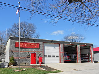
East Lansdowne is a borough in Delaware County, Pennsylvania, United States. The population was 2,668 at the 2010 census.

<span class="mw-page-title-main">Folcroft, Pennsylvania</span> Borough in Pennsylvania, United States

Folcroft is a borough in Delaware County, Pennsylvania, United States. The population was 6,606 at the 2010 census, down from 6,978 at the 2000 census.

<span class="mw-page-title-main">Glenolden, Pennsylvania</span> Borough in Pennsylvania, United States

Glenolden is a borough in Delaware County, Pennsylvania, United States. The population was 7,153 at the 2010 census, down from 7,476 at the 2000 census.

<span class="mw-page-title-main">Lansdowne, Pennsylvania</span> Borough in Pennsylvania, United States

Lansdowne is a borough in Delaware County, Pennsylvania, United States, located 6 miles (10 km) southwest of Center City Philadelphia. It was named for the Marquess of Lansdowne. As of the 2010 census, the borough had a population of 10,620.

<span class="mw-page-title-main">Millbourne, Pennsylvania</span> A borough located in Delaware County, Pennsylvania, United States

MillbourneBorough is a self-governing municipal borough in Delaware County, Pennsylvania, United States. As of the 2020 census, the population is 1,212. Millbourne borders Philadelphia along Cobbs Creek. The name "Millbourne" comes from the word Mill and "bourne" meaning creek. Millbourne, at over 17,000 people per square mile, is the most densely populated incorporated place in Pennsylvania, and 24th in the entire United States.

<span class="mw-page-title-main">Norwood, Pennsylvania</span> Borough in Pennsylvania, United States

Norwood is a borough that is located in Delaware County, Pennsylvania, United States. The population was 5,890 at the time of the 2010 census.

<span class="mw-page-title-main">Ridley Park, Pennsylvania</span> Borough in Pennsylvania, United States

Ridley Park is a borough in Delaware County, Pennsylvania, United States. The population was 7,002 at the 2010 census. Ridley Park is the home of Boeing's CH-47 Chinook helicopter division.

<span class="mw-page-title-main">Sharon Hill, Pennsylvania</span> Borough in Pennsylvania, United States

Sharon Hill is a borough in Delaware County, Pennsylvania, United States. The population was 5,697 at the 2010 census. Currently the population stands at 6,356 residents.

<span class="mw-page-title-main">Springfield Township, Delaware County, Pennsylvania</span> Township in Pennsylvania, United States

Springfield Township, or simply Springfield, is a township in Delaware County in the U.S. state of Pennsylvania. The population was 25,070 at the 2020 census. Springfield is a suburb of Philadelphia, located about 4 miles (6.4 km) west of the city.

<span class="mw-page-title-main">Upper Darby Township, Pennsylvania</span> Home rule township in Pennsylvania, United States

Upper Darby Township, often shortened to Upper Darby, is a home rule township in Delaware County, Pennsylvania, United States. As of the 2020 census, the township had a total population of 85,681, making it the state's sixth most populated municipality after Philadelphia, Pittsburgh, Allentown, Reading, and Erie. Upper Darby borders Philadelphia, the nation's sixth most populous city, and constitutes part of the Delaware Valley metropolitan area, the nation's seventh-largest metropolitan area.

<span class="mw-page-title-main">Yeadon, Pennsylvania</span> Borough in Pennsylvania, United States

Yeadon is a borough in Delaware County, Pennsylvania, United States. It borders the city of Philadelphia. The population was 11,443 at the 2010 census.

<span class="mw-page-title-main">Darby Township, Pennsylvania</span> First Class Township in Pennsylvania, United States

Darby Township is a township in Delaware County, Pennsylvania, United States. The population was 9,264 as of the 2010 census. It is home to both residential areas and expansive industrial districts. Darby Township is home to a diverse population and its industrial districts are popular among shipping companies for their proximity to Philadelphia International Airport. It also is known for being made up of two non-contiguous geographical areas, requiring one to pass through at least two neighboring municipalities to make it from one end of Darby Township to the other. Darby Township is a distinct municipality from the nearby and similarly named Darby Borough and Upper Darby Township.

<span class="mw-page-title-main">Tinicum Township, Delaware County, Pennsylvania</span> Township in Pennsylvania, United States

Tinicum Township, also known as Tinicum Island or The Island, is a township in Delaware County, Pennsylvania, United States. The population was 4,091 at the 2010 census, down from 4,353 at the 2000 census. Included within the township's boundaries are the communities of Essington and Lester.

<span class="mw-page-title-main">William Penn School District</span> School district in Pennsylvania

The William Penn School District is a large suburban, public school district located in Delaware County, Pennsylvania. It comprises eight elementary schools, one middle school, one alternative school, and one high school, based on two campuses. The district serves the boroughs of Aldan, Colwyn, Darby, East Lansdowne, Lansdowne, and Yeadon. The district is adjacent to the City of Philadelphia. The total enrollment is about 5,610. The district encompasses approximately 5 square miles. According to 2000 local census data, it serves a resident population of 42,457.The district administration offices are located at 100 Green Avenue – Annex Lansdowne, PA 19050.

Penn Wood High School is a high school that occupies two campuses. One in Lansdowne, Pennsylvania, USA, and one in Yeadon, Pennsylvania, USA.

References

  1. "ArcGIS REST Services Directory". United States Census Bureau. Retrieved October 12, 2022.
  2. 1 2 "Census Population API". United States Census Bureau. Retrieved Oct 12, 2022.
  3. 1 2 "Geographic Identifiers: 2010 Demographic Profile Data (G001): Colwyn borough, Pennsylvania". U.S. Census Bureau, American Factfinder. Archived from the original on February 13, 2020. Retrieved December 23, 2015.
  4. "US Gazetteer files: 2010, 2000, and 1990". United States Census Bureau. 2011-02-12. Retrieved 2011-04-23.
  5. "Colwyn Borough map" (PDF). PennDOT. Retrieved March 12, 2023.
  6. "Census 2020".
  7. [ dead link ]
  8. McCabe, Caitlin (6 May 2015). "It's official: Troubled Delco town 'distressed'". The Philadelphia Inquirer. Retrieved 7 May 2015.
  9. McCabe (25 May 2015). "Colwyn: Can this town be saved?". Philadelphia Daily News. Retrieved 26 May 2015.
  10. "2020 CENSUS - SCHOOL DISTRICT REFERENCE MAP: Delaware County, PA" (PDF). U.S. Census Bureau . Retrieved 2023-11-05.
  11. Hilferty, John (1972-11-05). "East Lansdowne's Heart Big". The Philadelphia Inquirer . Philadelphia. pp. 1 N-W, N–W. - Clipping of first and of second page at Newspapers.com.
Preceded by Bordering communities
of Philadelphia
Succeeded by