East Lansdowne, Pennsylvania

Last updated
East Lansdowne, Pennsylvania
East Lansdowne (PA) Fire Dept.JPG
East Lansdowne Fire Department
Delaware County Pennsylvania incorporated and unincorporated areas East Lansdowne highlighted.svg
Location in Delaware County and the U.S. state of Pennsylvania
USA Pennsylvania location map.svg
Red pog.svg
East Lansdowne
Location in Pennsylvania
Usa edcp location map.svg
Red pog.svg
East Lansdowne
Location in the United States
Coordinates: 39°56′39″N75°15′37″W / 39.94417°N 75.26028°W / 39.94417; -75.26028
CountryUnited States
StatePennsylvania
County Delaware
Area
[1]
  Total0.21 sq mi (0.53 km2)
  Land0.21 sq mi (0.53 km2)
  Water0.00 sq mi (0.00 km2)
Elevation
118 ft (36 m)
Population
 (2020) [2]
  Total2,714
  Density13,174.76/sq mi (5,078.75/km2)
Time zone UTC-5 (EST)
  Summer (DST) UTC-4 (EDT)
ZIP code
19050
Area codes 610 and 484
FIPS code 42-21384
Website www.eastlansdowne.org

East Lansdowne is a borough in Delaware County, Pennsylvania, United States. The population was 2,668 at the 2010 census.

Contents

Geography

East Lansdowne is located at 39°56′39″N75°15′37″W / 39.94417°N 75.26028°W / 39.94417; -75.26028 (39.944162, -75.260253). [3]

According to the United States Census Bureau, the borough has a total area of 0.2 square miles (0.52 km2), all land.

East Lansdowne is located about approximately one-half mile west of Southwest Philadelphia and is surrounded by Upper Darby Township, namely the Stonehurst/Stonehurst Hills/69th Street and Fernwood neighborhoods. Union Avenue to the west separates Lansdowne from Upper Darby, while the East Lansdowne border is near Hirst Avenue, leaving a one-block expanse of land that is part of Upper Darby Township. It is the former railroad track that gives East Lansdowne borough's western boundary that vaguely ovoid shape.

The borough of Yeadon is south of SEPTA's Media/Wawa Line railroad tracks, about one block south of East Lansdowne.

Education

William Penn School District serves East Lansdowne. The district was created in 1972. [4]

Private schools

Saint Cyril of Alexandria Catholic Elementary School (K-8), founded in September, 1929, [5] was moved to and combined with St. Philomena in nearby Lansdowne, PA in 2021 [6] after a protracted battle to keep the school open.

In December, 2005 the archdiocese proposed closing it, but it remained open after community members, inspired by a child with cystic fibrosis who asked for the Make a Wish foundation to save his school, donated $200,000 to keep it open. This was dubbed the "Miracle at St. Cyril." In 2012 the Roman Catholic Archdiocese of Philadelphia proposed closing it again, [7] intending to merge it into St. Andrew School of Upper Darby. However the archdiocese reversed that decision. [8] Instead it became the Independence Mission Schools, not operated by the archdiocese. [5] In 2012 there were 207 students. [9]

Vision Academy Charter School purchased the St. Cyril of Alexandria buildings from the Archdiocese of Philadelphia and opened during the 2021-22 school year. [6]

Religion

The Roman Catholic Archdiocese of Philadelphia operates Catholic churches. St. Cyril of Alexandria Church in East Lansdowne opened in June 1928. [10] In 2013, St. Cyril of Alexandria merged into St. Philomena Church in Lansdowne, with the St. Cyril parish closed. [11]

Demographics

Historical population
CensusPop.Note
1920 1,561
1930 3,168102.9%
1940 3,3234.9%
1950 3,5276.1%
1960 3,224−8.6%
1970 3,186−1.2%
1980 2,806−11.9%
1990 2,691−4.1%
2000 2,586−3.9%
2010 2,6683.2%
2020 2,7141.7%
[12] [2]

2020

East Lansdowne, Pennsylvania – Racial and ethnic composition
Note: the US Census treats Hispanic/Latino as an ethnic category. This table excludes Latinos from the racial categories and assigns them to a separate category. Hispanics/Latinos may be of any race.
Race / Ethnicity (NH = Non-Hispanic)Pop 2000 [13] Pop 2010 [14] Pop 2020 [15] % 2000% 20102020
White alone (NH)1,83379042970.88%29.61%15.81%
Black or African American alone (NH)5211,4521,78020.15%54.42%65.59%
Native American or Alaska Native alone (NH)2360.08%0.11%0.22%
Asian alone (NH)1562322016.03%8.70%7.41%
Pacific Islander alone (NH)0600.00%0.22%0.00%
Some Other Race alone (NH)36260.12%0.22%0.96%
Mixed Race or Multi-Racial (NH)39631011.51%2.36%3.72%
Hispanic or Latino (any race)321161711.24%4.35%6.30%
Total2,5862,6682,714100.00%100.00%100.00%

2010

As of Census 2010, the racial makeup of the borough was 30.5% White, 55.8% African American, 0.1% Native American, 8.8% Asian, 0.2% Native Hawaiian and Other Pacific Islander, 1.3% from other races, and 3.1% from two or more races. Hispanic or Latino of any race were 4.3% of the population. 22.1% of the borough's population was foreign-born .

As of Census 2000, the population density was 12,517.6 inhabitants per square mile (4,833.1/km2). There were 1,012 housing units at an average density of 4,898.6 per square mile (1,891.4/km2). The racial makeup of the borough was 71.2% White, 26.8% African American, 0.08% Native American, 6.03% Asian, 0.46% from other races, and 1.70% from two or more races. Hispanic or Latino of any race were 1.24% of the population.

There were 938 households, out of which 32.8% had children under the age of 18 living with them, 45.6% were married couples living together, 12.7% had a female householder with no husband present, and 35.1% were non-families. 28.9% of all households were made up of individuals, and 10.3% had someone living alone who was 65 years of age or older. The average household size was 2.71 and the average family size was 3.41.

In the borough the population was spread out, with 25.8% under the age of 18, 8.6% from 18 to 24, 31.7% from 25 to 44, 19.9% from 45 to 64, and 14.0% who were 65 years of age or older. The median age was 37 years. For every 100 females there were 100.2 males. For every 100 females age 18 and over, there were 93.6 males.

The median income for a household in the borough was $44,205, and the median income for a family was $53,021. Males had a median income of $37,813 versus $28,409 for females. The per capita income for the borough was $19,558. About 6.2% of families and 7.6% of the population were below the poverty line, including 4.9% of those under age 18 and 10.0% of those age 65 or over.

Transportation

Pembroke Avenue in East Lansdowne 2022-10-24 13 29 03 View west along Pembroke Avenue at Penn Boulevard in East Lansdowne, Delaware County, Pennsylvania.jpg
Pembroke Avenue in East Lansdowne

As of 2014, there were 5.03 miles (8.10 km) of public roads in East Lansdowne, of which 0.66 miles (1.06 km) were maintained by the Pennsylvania Department of Transportation (PennDOT) and 4.37 miles (7.03 km) were maintained by the borough. [16]

No numbered highways serve East Lansdowne directly. The main thoroughfares in the borough include Pembroke Avenue and Church Lane, which intersect near the eastern edge of the borough.

Notable features

Oldest 4th of July parade and celebration in Delaware County. [17]

Related Research Articles

<span class="mw-page-title-main">Delaware County, Pennsylvania</span> County in Pennsylvania, United States

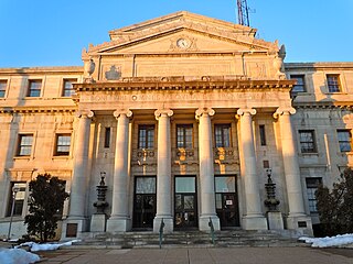
Delaware County, colloquially referred to as Delco, is a county in the Commonwealth of Pennsylvania. With a population of 576,830 as of the 2020 census, it is the fifth-most populous county in Pennsylvania and the third-smallest in area. The county was created on September 26, 1789, from part of Chester County and named for the Delaware River. The county is part of the Southeast Pennsylvania region of the state.

<span class="mw-page-title-main">Avondale, Pennsylvania</span> Borough in Pennsylvania, United States

Avondale is a borough in Chester County, in southeastern Pennsylvania, United States. The population was 1,272 at the 2020 census.

<span class="mw-page-title-main">Aldan, Pennsylvania</span> Borough in Pennsylvania, United States

Aldan is a borough in Delaware County, Pennsylvania, United States. The population was 4,244 at the 2020 census.

<span class="mw-page-title-main">Brookhaven, Pennsylvania</span> Borough in Pennsylvania, United States

Brookhaven is a borough in Delaware County, Pennsylvania, United States. The population was 8,300 at the 2020 census.

<span class="mw-page-title-main">Collingdale, Pennsylvania</span> Borough in Pennsylvania, United States

Collingdale is a borough in Delaware County, Pennsylvania, United States. The population was 8,908 at the 2020 census.

<span class="mw-page-title-main">Colwyn, Pennsylvania</span> Borough in Pennsylvania, United States

Colwyn is a borough in Delaware County, Pennsylvania, United States. The population was 2,546 at the 2010 census.

<span class="mw-page-title-main">Darby, Pennsylvania</span> Borough in Pennsylvania, United States

Darby is a borough in Delaware County, Pennsylvania, United States. The borough is located along Darby Creek 5 miles (8.0 km) southwest of Center City Philadelphia. The borough of Darby is distinct from the nearby municipality of Darby Township.

<span class="mw-page-title-main">Eddystone, Pennsylvania</span> Borough in Pennsylvania, United States

Eddystone is a borough in Delaware County, Pennsylvania, United States. The population was 2,410 at the 2010 census.

<span class="mw-page-title-main">Folcroft, Pennsylvania</span> Borough in Pennsylvania, United States

Folcroft is a borough in Delaware County, Pennsylvania, United States. The population was 6,606 at the 2010 census, down from 6,978 at the 2000 census.

<span class="mw-page-title-main">Lansdowne, Pennsylvania</span> Borough in Pennsylvania, United States

Lansdowne is a borough in Delaware County, Pennsylvania, United States, located 6 miles (10 km) southwest of Center City Philadelphia. It was named for the Marquess of Lansdowne. As of the 2010 census, the borough had a population of 10,620.

<span class="mw-page-title-main">Linwood, Pennsylvania</span> Census-designated place in Pennsylvania, United States

Linwood is a census-designated place (CDP) in Delaware County, Pennsylvania, United States. The population was 3,281 at the 2010 census.

<span class="mw-page-title-main">Lower Chichester Township, Pennsylvania</span> Township in Pennsylvania, United States

Lower Chichester Township is a township in Delaware County, Pennsylvania, United States. The population was 3,469 at the 2010 census. It contains the census designated place of Linwood.

<span class="mw-page-title-main">Marcus Hook, Pennsylvania</span> Borough in Pennsylvania, United States

Marcus Hook is a borough in Delaware County, Pennsylvania, United States. The population was 2,397 at the 2010 census. The current mayor is Gene Taylor. The borough calls itself "The Cornerstone of Pennsylvania". The 2005 film One Last Thing... was set and partially filmed in Marcus Hook.

<span class="mw-page-title-main">Norwood, Pennsylvania</span> Borough in Pennsylvania, United States

Norwood is a borough that is located in Delaware County, Pennsylvania, United States. The population was 5,890 at the time of the 2010 census.

<span class="mw-page-title-main">Ridley Township, Pennsylvania</span> Township in Pennsylvania, United States

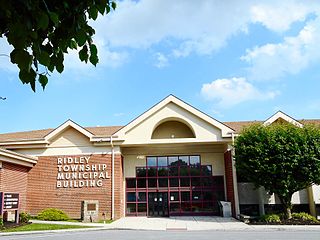
Ridley Township is a township in Delaware County, Pennsylvania, United States. The population was 30,768 at the 2010 census. Ridley Township contains the (CDPs) of Folsom and Woodlyn, along with the unincorporated communities of Crum Lynne and Holmes and a portion of Secane.

<span class="mw-page-title-main">Ridley Park, Pennsylvania</span> Borough in Pennsylvania, United States

Ridley Park is a borough in Delaware County, Pennsylvania, United States. The population was 7,002 at the 2010 census. Ridley Park is the home of Boeing's CH-47 Chinook helicopter division.

<span class="mw-page-title-main">Sharon Hill, Pennsylvania</span> Borough in Pennsylvania, United States

Sharon Hill is a borough in Delaware County, Pennsylvania, United States. The population was 5,697 at the 2010 census. Currently the population stands at 6,356 residents.

<span class="mw-page-title-main">Springfield Township, Delaware County, Pennsylvania</span> Township in Pennsylvania, United States

Springfield Township, or simply Springfield, is a township in Delaware County in the U.S. state of Pennsylvania. The population was 25,070 at the 2020 census. Springfield is a suburb of Philadelphia, located about 4 miles (6.4 km) west of the city.

<span class="mw-page-title-main">Upper Darby Township, Pennsylvania</span> Home rule township in Pennsylvania, United States

Upper Darby Township, often shortened to Upper Darby, is a home rule township in Delaware County, Pennsylvania, United States. As of the 2020 census, the township had a total population of 85,681, making it the state's sixth-most populated municipality after Philadelphia, Pittsburgh, Allentown, Reading, and Erie. Upper Darby borders Philadelphia, the nation's sixth-most populous city, and constitutes part of the Delaware Valley, also known as the Philadelphia metropolitan area, the nation's seventh-largest metropolitan area.

<span class="mw-page-title-main">Yeadon, Pennsylvania</span> Borough in Pennsylvania, United States

Yeadon is a borough in Delaware County, Pennsylvania, United States. It borders the city of Philadelphia. The population was 11,443 at the 2010 census.

References

  1. "ArcGIS REST Services Directory". United States Census Bureau. Retrieved October 12, 2022.
  2. 1 2 "Census Population API". United States Census Bureau. Retrieved Oct 12, 2022.
  3. "US Gazetteer files: 2010, 2000, and 1990". United States Census Bureau. 2011-02-12. Retrieved 2011-04-23.
  4. 1 2 Hilferty, John (1972-11-05). "East Lansdowne's Heart Big". The Philadelphia Inquirer . Philadelphia. pp. 1 N-W, N–W. - Clipping of first and of second page at Newspapers.com.
  5. 1 2 "History". Saint Cyril of Alexandria Catholic Elementary School. Retrieved 2020-05-03.
  6. 1 2 DeGrassa, Peg (June 26, 2021). "Newly named SS. Cyril & Philomena school relocates to St. Philomena". Delco Times. Retrieved January 11, 2024.
  7. Polaneczky, Ronnie (2012-01-10). "Ronnie Polaneczky: St. Cyril in need of another miracle". The Philadelphia Inquirer . Retrieved 2019-11-30.
  8. Mengers, Patti (2012-02-17). "Good news for St. Cyril, St. Andrew in archdiocesan appeals". Delco Times . Retrieved 2020-05-04.
  9. Mengers, Patti (2012-02-17). "It's good news for five Catholic grade schools". Delco Times . Retrieved 2020-05-04.
  10. "St. Cyril of Alexandria". Roman Catholic Archdiocese of Philadelphia. 2009-04-15. Archived from the original on 2009-04-15. Retrieved 2020-05-03.
  11. Mengers, Patti (2013-06-30). "5 Delco parishes lament closures". Delco Times . Archived from the original on 2020-05-03. Retrieved 2020-05-03.
  12. "Census 2020".
  13. "P004 Hispanic or Latino, and Not Hispanic or Latino by Race – 2000: DEC Summary File 1 – East Lansdowne borough, Pennsylvania". United States Census Bureau .
  14. "P2 Hispanic or Latino, and Not Hispanic or Latino by Race – 2010: DEC Redistricting Data (PL 94-171) – East Lansdowne borough, Pennsylvania". United States Census Bureau .
  15. "P2 Hispanic or Latino, and Not Hispanic or Latino by Race – 2020: DEC Redistricting Data (PL 94-171) – East Lansdowne borough, Pennsylvania". United States Census Bureau .
  16. "East Lansdowne Borough map" (PDF). PennDOT. Retrieved March 12, 2023.
  17. Carey, Kathleen E. (July 4, 2015). "East Lansdowne celebrates its 100th Fourth of July parade". Delco Times. Retrieved January 11, 2024.