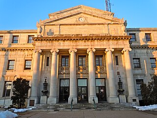
Delaware County, colloquially referred to as Delco, is a county in the Commonwealth of Pennsylvania. With a population of 576,830 as of the 2020 census, it is the fifth-most populous county in Pennsylvania and the third-smallest in area. The county was created on September 26, 1789, from part of Chester County and named for the Delaware River.

Eddystone is a borough in Delaware County, Pennsylvania, United States. The population was 2,410 at the 2010 census.
Morton is a borough in Delaware County, Pennsylvania, United States. The population was 2,778 at the 2020 census.
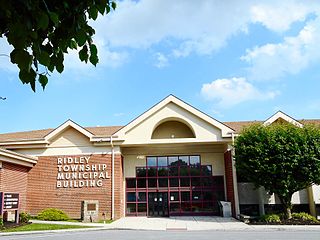
Ridley Township is a township in Delaware County, Pennsylvania, United States. The population was 30,768 at the 2010 census. Ridley Township contains the (CDPs) of Folsom and Woodlyn, along with the unincorporated communities of Crum Lynne and Holmes and a portion of Secane.

Ridley Park is a borough in Delaware County, Pennsylvania, United States. The population was 7,002 at the 2010 census. Ridley Park is the home of Boeing's CH-47 Chinook helicopter division.
Springfield Township, or simply Springfield, is a township in Delaware County in the U.S. state of Pennsylvania. The population was 25,070 at the 2020 census. Springfield is a suburb of Philadelphia, located about 4 miles (6.4 km) west of the city.

Swarthmore is a borough in Delaware County, Pennsylvania, United States. Swarthmore was originally named "Westdale" in honor of noted painter Benjamin West, who was one of the early residents of the town. The name was changed to "Swarthmore" after the establishment of Swarthmore College. The borough population was 6,194 as of the 2010 census.
Telford is a borough in Bucks and Montgomery counties in the U.S. state of Pennsylvania. The population was 4,872 at the time of the 2010 census. Of this, 2,665 were in Montgomery County, and 2,207 were in Bucks County.

Nether Providence Township is a first class township in Delaware County, Pennsylvania, United States. Many residents refer to the township by the name of its largest community, Wallingford, because the Wallingford postal code is used for most of the township. The population of the township was 13,706 at the 2010 census.

Tinicum Township, also known as Tinicum Island or The Island, is a township in Delaware County, Pennsylvania, United States. The population was 4,091 at the 2010 census, down from 4,353 at the 2000 census. Included within the township's boundaries are the communities of Essington and Lester.

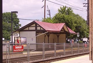
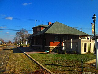
Crum Lynne station is a station on the SEPTA Wilmington/Newark Line. Though the station sits along the Northeast Corridor, it is not served by any Amtrak intercity services. The station, located at Chester Pike & West Ridley Avenue in Ridley Park, Pennsylvania, is actually northeast of the community the station is named for. It was named by a then-Pennsylvania Railroad vice president after Crumlin, Wales, where his mother was born. It includes a 14-space parking lot, and sheltered platforms on both West Ridley Avenue and Chester Pike.

Ridley Creek State Park is a 2,606-acre (1,055 ha) Pennsylvania state park in Edgmont, Middletown, and Upper Providence Townships, Delaware County, Pennsylvania in the United States. The park, about 5 miles (8 km) north of the county seat of Media, offers many recreational activities, such as hiking, biking, fishing, and picnicking. Ridley Creek passes through the park. Highlights include a 5-mile (8 km) paved multi-use trail, a formal garden designed by the Olmsted Brothers, and Colonial Pennsylvania Plantation, which recreates daily life on a pre-Revolutionary farm. The park is adjacent to the John J. Tyler Arboretum. Ridley Creek State Park is just over 16 miles (26 km) from downtown, Philadelphia between Pennsylvania Route 352 and Pennsylvania Route 252 on Gradyville Road.

Chester Creek is a 9.4-mile-long (15.1 km) tributary of the Delaware River in Delaware County, Pennsylvania in the United States.

Ridley Creek is a tributary of the Delaware River in Chester and Delaware counties, Pennsylvania in the United States.
Crum Creek is a creek in Delaware County and Chester County, Pennsylvania, flowing approximately 24 miles (39 km), generally in a southward direction and draining into the Delaware River in Eddystone, Pennsylvania. It begins in a swamp near Newtown Square, Pennsylvania along which several mills were established in the 19th century. Right afterward it crosses under Pennsylvania Route 29 and winds one and a half miles (2.4 km) downstream until it hits the hamlet of Crum Creek. It later flows into the Delaware River near Philadelphia.
The Leiper Railroad was a 'family business–built' horse drawn railroad of 0.75 miles (1.21 km), constructed in 1810 after the quarry owner, Thomas Leiper, failed to obtain a charter with legal rights-of-way to instead build his desired canal along Crum Creek. The quarry man's 'make-do' railroad was the continent's first chartered railway, first operational non-temporary railway, first well-documented railroad, and first constructed railroad also meant to be permanent.
The credit of constructing the first permanent tramway in America may therefore be rightly given to Thomas Leiper. He was the owner of a fine quarry not far from Philadelphia, and was much concerned to find an easy mode of carrying stone to tide-water. That a railway would accomplish this end he seem to have had no doubt. To test the matter, and at the same time afford a public exhibition of the merits of tramways, he built a temporary track in the yard of the Bull's Head Tavern in Philadelphia. The tramway was some sixty feet long, had a grade of one inch and a half to the yard, and up it, to the amazement of the spectators, one horse used to draw a four-wheeled wagon loaded with a weight of ten thousand pounds. This was the summer of 1809. Before autumn laborers were at work building a railway from the quarry to the nearest landing, a distance of three quarters of a mile. In the spring of 1810 the road began to be used and continued in using during eighteen years.
by John Bach McMaster, page 494, A History of the People of the United States, from the Revolution to the Civil War

U.S. Route 13 (US 13) is a United States Numbered Highway running from Fayetteville, North Carolina, north to Morrisville, Pennsylvania. The route runs for 49.359 miles (79.436 km) through the Delaware Valley in the U.S. state of Pennsylvania. The route enters the state from Delaware in Marcus Hook, Delaware County. It continues northeast through Delaware County, passing through the city of Chester before heading through suburban areas along Chester Pike to Darby. US 13 enters the city of Philadelphia on Baltimore Avenue and runs through West Philadelphia to University City, where it turns north along several city streets before heading east across the Schuylkill River along Girard Avenue. The route turns north and heads to North Philadelphia, where it runs northeast along Hunting Park Avenue. US 13 becomes concurrent with US 1 on Roosevelt Boulevard, continuing into Northeast Philadelphia. US 13 splits southeast on a one-way pair of streets before heading northeast out of the city on Frankford Avenue. The route continues into Bucks County as Bristol Pike, heading northeast to Bristol, where it turns into a divided highway. US 13 becomes a freeway in Tullytown and continues north to its terminus at US 1 in Falls Township, near Morrisville. US 13 roughly parallels Interstate 95 (I-95) through its course in Pennsylvania.

Early in the 19th century, the Leiper Canal built in 1828–29 during the middle of the American canal age ran about 3 miles (5 km) along Crum Creek in Delaware County to its mouth in eastern Pennsylvania's Delaware Valley carrying its owner‘s quarried products to docks on the Delaware River tidewater until 1852.

Strasburg Road was an early road in Pennsylvania connecting Philadelphia to Strasburg in Lancaster County. The route was surveyed by John Sellers and others in 1772-3 under the colonial administration of Governor Richard Penn and completed under the new administration of the independent state of Pennsylvania. The route started at the "second ferry" on the Schuylkill River, today's Market Street in Philadelphia, and went through West Chester, East Fallowfield Township, and Gap, before ending in Strasburg. Earlier roads travelled much the same route, including a Native American path in use as early as 1620.
Spratt is an unincorporated community in Muskingum County, in the U.S. state of Ohio.


