
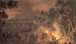
The Battle of Brandywine, also known as the Battle of Brandywine Creek, was fought between the American Continental Army of General George Washington and the British Army of General Sir William Howe on September 11, 1777, as part of the American Revolutionary War (1775–1783). The forces met near Chadds Ford, Pennsylvania. More troops fought at Brandywine than at any other battle of the American Revolution. It was also the second longest single-day battle of the war, after the Battle of Monmouth, with continuous fighting for 11 hours.
The Battle of Paoli, also known as the Battle of Paoli Tavern or the Paoli Massacre, was a battle in the Philadelphia campaign of the American Revolutionary War fought on September 20, 1777, in the area surrounding present-day Malvern, Pennsylvania. Following the Continental Army's retreat in the Battle of Brandywine and the aborted Battle of the Clouds, George Washington left a force behind under the command of Brigadier General Anthony Wayne to monitor and resist the British as they prepared to attack and occupy the revolutionary capital of Philadelphia.

Brandywine Creek is a tributary of the Christina River in southeastern Pennsylvania and northern Delaware in the United States. The Lower Brandywine is 20.4 miles (32.8 km) long and is a designated Pennsylvania Scenic River with several tributary streams. The East Branch and West Branch of the creek originate within 2 miles (3 km) of each other on the slopes of Welsh Mountain in Honey Brook Township, Pennsylvania, about 20 miles (32 km) northwest of their confluence.

Chadds Ford Township is an affluent township in Delaware County, Pennsylvania, United States. It is located about 25 miles (40 km) southwest of Philadelphia.

Pennsylvania Route 52 is a 11.8-mile-long (19.0 km) state highway located in southeast Pennsylvania. The southern terminus of the route is at the Pennsylvania-Delaware state line near Kennett Square, where the road continues as Delaware Route 52. The northern terminus is at U.S. Route 322 Business in West Chester. Near the Kennett Township community of Longwood, it has about a 1-mile (1.6 km) wrong-way concurrency with US 1. PA 52 passes through suburban and rural areas along its route.
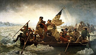
Pennsylvania was the site of many key events associated with the American Revolution and American Revolutionary War. The city of Philadelphia, then capital of the Thirteen Colonies and the largest city in the colonies, was a gathering place for the Founding Fathers who discussed, debated, developed, and ultimately implemented many of the acts, including signing the Declaration of Independence, that inspired and launched the revolution and the quest for independence from the British Empire.
The Baltimore Pike was an auto trail connecting Baltimore, Maryland, with Philadelphia, Pennsylvania.

Willowdale is an unincorporated community that is located in East Marlborough Township, in southern Chester County, Pennsylvania, United States.
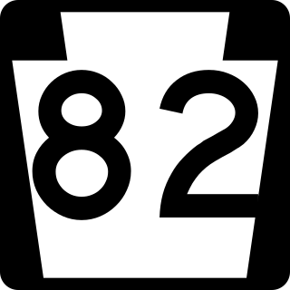
Pennsylvania Route 82 is a 32-mile-long (51 km) north–south state highway located in Chester County in southeast Pennsylvania, USA. The southern terminus is at the Delaware state line southeast of Kennett Square, where the road continues south into that state as Delaware Route 82. The northern terminus is at PA 23 in Elverson. PA 82 heads through rural areas of Chester County along with the communities of Kennett Square, Unionville, and Coatesville. The route intersects many important roads including U.S. Route 1 near Kennett Square, PA 162 and PA 842 in Unionville, US 30 in Coatesville, and US 322 in Brandywine Manor. PA 82 is a two-lane undivided road most of its length.

Pennsylvania Route 162 is a 10.1-mile-long (16.3 km) state highway in southeast Pennsylvania. The western terminus of the route is at PA 82/PA 842 in Unionville, Chester County. The eastern terminus is at U.S. Route 322 Business in West Chester. PA 162 is known as Embreeville Road from its western terminus to the village of Embreeville and Telegraph Road from Embreeville to an intersection with Strasburg Road west of Marshallton. At this point, the route turns east, following Strasburg Road to US 322 Bus. in West Chester. The portion of road between Marshallton and West Chester follows the 17th-century Great Minquas Path and became part of the Strasburg Road linking Strasburg and Philadelphia in the 1770s. PA 162 was designated onto its current alignment by 1930.

U.S. Route 1 (US 1) is a major north–south U.S. Route, extending from Key West, Florida, in the south to Fort Kent, Maine, at the Canada–United States border in the north. In the U.S. state of Pennsylvania, US 1 runs for 81 miles (130 km) from the Maryland state line near Nottingham northeast to the New Jersey state line at the Delaware River in Morrisville, through the southeastern portion of the state. The route runs southwest to northeast and serves as a major arterial road through the city of Philadelphia and for many of the suburbs in the Delaware Valley metropolitan area. South of Philadelphia, the road mostly follows the alignment of the Baltimore Pike. Within Philadelphia, it mostly follows Roosevelt Boulevard. North of Philadelphia, US 1 parallels the route of the Lincoln Highway. Several portions of US 1 in Pennsylvania are freeways, including from near the Maryland state line to Kennett Square, the bypass of Media, the concurrency with Interstate 76 and the Roosevelt Expressway in Philadelphia, and between Bensalem Township and the New Jersey state line.
The Brandywine Battlefield Historic Site is a National Historical Landmark. The historic park is owned and operated by the Pennsylvania Historical and Museum Commission, on 52 acres (210,000 m2), near Chadds Ford, Delaware County, Pennsylvania in the United States.
The Battle of the Clouds was an aborted engagement of the Philadelphia campaign of the American Revolutionary War on September 16, 1777, in the area surrounding present day Malvern, Pennsylvania. After the American defeat at the Battle of Brandywine, the British Army remained encamped near Chadds Ford. When British commander William Howe was informed that the weakened American force was less than ten miles (16 km) away, he decided to press for another decisive victory.

Delaware Route 100 (DE 100) is a state highway in New Castle County, Delaware. The route runs from DE 4 near Elsmere to the Pennsylvania border near Montchanin, where it continues into Pennsylvania as State Route 3100. The road runs through suburban areas of northern New Castle County. The route intersects DE 2 in Elsmere before forming separate concurrencies with DE 48 and DE 141 from west of Wilmington north to Greenville. In Greenville, there is an interchange with DE 52. North of Greenville, DE 100 continues by itself to the Pennsylvania border, intersecting DE 92 in Montchanin. DE 100 was first designated in the 1930s to run from DE 52 to the Pennsylvania border, where it connected to Pennsylvania Route 100 (PA 100) until the southern terminus of that route was truncated away from the state line in 2003. By the 1970s, it was extended south to DE 4. The route was realigned to follow parts of DE 48 and DE 141 by 1990.

Pennsylvania Route 842 is a state highway in Chester County, Pennsylvania. The route runs from PA 841 in West Marlborough Township to U.S. Route 322 Business in downtown West Chester. PA 842 runs through rural areas with some development between PA 841 and West Chester as a two-lane undivided road. Along this stretch, the route forms a concurrency with PA 82 in Unionville, where it intersects the western terminus of PA 162. In West Chester, PA 842 is routed along one-way streets. PA 842 was first designated by 1928 between PA 82 in Unionville and US 122/PA 5/PA 62 in West Chester. The route was extended west to PA 841 in 1937.

U.S. Route 30 Business is a 19-mile (31 km) business route of US 30 in Chester County, Pennsylvania. The route follows the former alignment of US 30 between Sadsbury Township and East Whiteland Township, passing through Coatesville, Downingtown, and Exton. US 30 follows a freeway bypass between these two points. The present alignment of US 30 Bus. was originally part of a turnpike called the Philadelphia and Lancaster Turnpike that was completed in 1794. The state took over the turnpike at the beginning of the 20th century. In 1913, present-day US 30 Bus. was incorporated into the Lincoln Highway, an auto trail that ran from San Francisco east to New York City. The Lincoln Highway through Pennsylvania became Pennsylvania Route 1 (PA 1) in 1924. US 30 was designated concurrent with PA 1 west of Philadelphia in 1926, with the PA 1 designation removed two years later. US 30 was widened into a multilane road through Chester County in the 1930s. In the 1960s, US 30 was moved to a freeway bypass around Coatesville and Downingtown, with US 30 Bus. designated onto the former alignment of US 30. In 1995, US 30 Bus. was extended east when US 30 was extended to bypass Exton.
Hanbys Corner is an unincorporated community in New Castle County, Delaware, United States. It is located at the intersection of Delaware Route 3 and Delaware Route 92, in Brandywine Hundred. The area is named for Richard G. Hanby, who first purchased the 125-acre (0.51 km2) parcel from the descendants of William Penn in 1753. His descendants included several notable figures in the local political scene including Samuel Winfield Hanby (1817-1892) who was elected as a State Representative in 1874, Jacob Klose Hanby (1839-1932) who was Samuel's son and was elected State Representative in 1904, Robert Johnson Hanby (1834-1898), who served in the 124th PA infantry during the Civil War and was elected State Senator in 1896, and Florence Wood Hanby (1870-1963), who was Robert's daughter-in-law and was the first woman elected to the Delaware House of Representatives in 1924. In addition Wayne Hanby and James Hanby have both served as Justices of the Peace for New Castle County. The last Hanby to occupy the property, Albert T. Hanby (1881-1947), another son of Samuel, attended West Chester State College before getting his law degree from Penn Law School. Albert became a Philadelphia lawyer and left his farm at Hanby's Corner to be used for the good of "all the children in Delaware". He and his wife created a foundation in 1945 to protect the property from further development. Today the YMCA operates their Hanby Camp there, and the trust provide scholarships for kids who might not otherwise be able to attend. In 2007 that support was over $70,000.

Trimbleville, Pennsylvania, also known as Trimble's Ford and the Trimbleville Historic District is a hamlet of roughly six homes that is located in southern Chester County, Pennsylvania, approximately two miles south of Marshallton.

St. Martin's Church is an Episcopal church founded in 1699 in Marcus Hook, Pennsylvania, United States. It is located at 22 Church Street, only 500 feet from the Delaware River. It is one of the earliest and last riverfront churches in Pennsylvania. The cemetery at St. Martin's Church contains a memorial commemorating war veterans from the Revolutionary War, the War of 1812, the Mexican–American War, the American Civil War, and the Spanish–American War who are buried in the cemetery.
Steelville is an unincorporated community in Chester County, Pennsylvania, United States. According to the 2016 census, the town has not been included in past census counts because the town is so small. It lies next to the Octoraro Creek: the border line between Lancaster County and Chester County.

