The Lower Glenelg National Park is a national park in the Western District of Victoria, Australia. The 27,300-hectare (67,000-acre) national park is situated approximately 323 kilometres (201 mi) west of Melbourne. The major features of the park are the Glenelg River gorge and the Princess Margaret Rose Cave. Much of the route of the Great South West Walk is located within the national park.

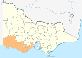
The Shire of Glenelg is a local government area in the Barwon South West region of Victoria, Australia, located in the south-western part of the state. It covers an area of 6,219 square kilometres (2,401 sq mi) and in June 2018 had a population of 19,665. It includes the towns of Casterton, Heywood, Merino and Portland. Although a shire of the same name existed before the amalgamations of the mid-1990s, the current Shire was formed in 1994 from the amalgamation of the former Shire of Glenelg with the Shire of Heywood and City of Portland.

Discovery Bay is an open oceanic embayment lying along the coast of eastern South Australia and western Victoria in south-eastern Australia.

The Moyne River, a perennial river of the Glenelg Hopkins catchment, is located in the Western District of Victoria, Australia.

The Hopkins River, a perennial river of the Glenelg Hopkins catchment, is located in the Western District of Victoria, Australia.
Glenelg Highway is a rural highway in south-eastern Australia, linking Mount Gambier with Ballarat. Most of the highway is located within the Western part of the state of Victoria, though a short, 15 km stretch from the South Australia/Victoria state border near Ardno to Glenburnie is located in South Australia. Some maps identify the South Australian stretch as Casterton Road. Major towns along its route include Casterton, Coleraine and Hamilton.

The Glenelg River, a perennial river of the Glenelg Hopkins catchment, is located in the Australian states of Victoria and South Australia.

The Woady Yaloak River is a perennial river of the Corangamite catchment, located in the Western District Lakes region of the Australian state of Victoria.

The Wannon River, a perennial river of the Glenelg Hopkins catchment, is located in the Western District of Victoria, Australia.
The Fitzroy River, a perennial river of the Glenelg Hopkins catchment, is located in the Western District of Victoria, Australia.
The Cobboboonee National Park is a national park located in the Barwon South West region of Victoria, Australia. The 18,510-hectare (45,700-acre) national park is situated approximately 360 kilometres (220 mi) west of Melbourne city centre, with access via the town of Heywood near the junctions of the Princes and Henty highways, north of Portland.
The Merri River, a perennial river of the Glenelg Hopkins catchment, is located in the Western District of Victoria, Australia.
The Shaw River, a perennial river of the Glenelg Hopkins catchment, is located in the Western District of Victoria, Australia.
The Surry River, sometimes incorrectly spelled as the Surrey River, a perennial river of the Glenelg Hopkins catchment, is located in the Western District of Victoria, Australia.

The Aire River is a perennial river of the Corangamite catchment, located in The Otways region of the Australian state of Victoria.
The Wando River, a perennial river of the Glenelg Hopkins catchment, is located in the Western District of Victoria, Australia.
The Dundas River, a perennial river of the Glenelg Hopkins catchment, is located in the Western District of Victoria, Australia.
The Chetwynd River, a perennial river of the Glenelg Hopkins catchment, is located in the Western District of Victoria, Australia.
The Stokes River, a perennial river of the Glenelg Hopkins catchment, is located in the Western District of Victoria, Australia.
The Barwon South West is an economic rural region located in the southwestern part of Victoria, Australia. The Barwon South West region stretches from the tip of the Queenscliff Heads to the border of South Australia. It is home to Victoria’s largest provincial centre, Geelong and the major centres of Aireys Inlet, Apollo Bay, Camperdown, Colac, Hamilton, Lorne, Port Campbell, Port Fairy, Portland, Torquay and Warrnambool. It draws its name from the Barwon River and the geographic location of the region in the state of Victoria.
