East Hartford, Connecticut

Last updated

East Hartford, Connecticut
Town
Town of East Hartford
EastHartfordCT Skyline.jpg
The skyline near the Connecticut River
EastHartfordCTflag.jpg
EastHartfordCTseal.jpg
Hartford County Connecticut Incorporated and Unincorporated areas East Hartford Highlighted.svg
Capitol Region incorporated and unincorporated areas East Hartford highlighted.svg
East Hartford, Connecticut
Coordinates: 41°45′41″N72°36′55″W / 41.76139°N 72.61528°W / 41.76139; -72.61528
CountryFlag of the United States.svg  United States
U.S. state Flag of Connecticut.svg  Connecticut
County Hartford
Region Capitol Region
Incorporated 1783
Government
  Type Mayor-council
   Mayor Michael P. Walsh (D)
Area
  Total18.7 sq mi (48.5 km2)
  Land18.0 sq mi (46.6 km2)
  Water0.7 sq mi (1.9 km2)
Elevation
[1]
49 ft (15 m)
Population
 (2020) [2]
  Total51,045
  Density2,837/sq mi (1,095.4/km2)
Time zone UTC−5 (Eastern)
  Summer (DST) UTC−4 (Eastern)
ZIP Codes
06108, 06118
Area code(s) 860/959
FIPS code 09-22630
GNIS feature ID0213424 [1]
Interstates I-84.svg
U.S. Highways US 5.svg US 44.svg
State Routes Connecticut Highway 2.svg
Website www.easthartfordct.gov

East Hartford is a town in the Capitol Planning Region, Connecticut, United States. The population was 51,045 at the 2020 census. [3] The town is located on the east bank of the Connecticut River, directly across from Hartford. [4] It is home to aerospace manufacturer Pratt & Whitney. It is also home to Pratt & Whitney Stadium at Rentschler Field, a stadium used mainly for soccer and football with a capacity of 40,000 people.

Contents

History

When the Connecticut Valley became known to Europeans around 1631, it was inhabited by what were known as the River Tribes—a number of small clans of Native Americans living along the Great River and its tributaries. Of these tribes the Podunks occupied territory now lying in the towns of East Hartford and South Windsor, and numbered, by differing estimates, from sixty to two hundred bowmen. They were governed by two sachems, Waginacut and Arramamet, and were connected in some way with the Native Americans who lived across the Great River, in what is now Windsor. The region north of the Hockanum River was generally called Podunk; that south of the river, Hockanum; but these were no certain designations, and by some all the meadow along the Great River was called Hockanum. [5]

In 1659, Thomas Burnham (1617–1688) purchased the tract of land now covered by the towns of South Windsor and East Hartford from Tantinomo, chief sachem of the Podunk Indians. [5] Burnham lived on the land and later willed it to his nine children. [6] The town of Hartford, founded in 1635, once included the land now occupied by the towns of East Hartford, Manchester, Bolton, Vernon, and West Hartford. During the Revolutionary War, French troops under Lieutenant General Comte de Rochambeau twice camped in town, before and after aiding General George Washington's forces in the 1781 defeat of the British during the Siege of Yorktown. [7]

East Hartford was incorporated as a separate town in October 1783. Manchester (then known as Orford Parish, adopting the name of a prominent English factory city) separated from East Hartford in 1823. [5] Beginning in the late nineteenth century, residents began to form tax districts for fire protection, street lighting, sanitation, and other public works improvements. The East Hartford Fire District was granted a charter by the General Assembly in 1889 and organized in June 1891. The Meadow Fire District existed before the turn of the twentieth century. The Hockanum Sewer District and Hockanum Lighting District were formed in 1915 and 1916 respectively. The Silver Lane Fire and Lighting District was founded in 1925. On June 10, 1929, voters of the town approved a new charter. All of the old districts were abolished and a Town Council would govern the municipality. [8]

Since first being settled, East Hartford's economy was primarily agricultural, with tobacco being the main crop. All that changed in 1929, when Frederick Rentschler, head of Pratt & Whitney, moved production from Hartford to a sprawling 1,100 acres (450 hectares) site in East Hartford. The grounds included a small airport called Rentschler Field that was in service from 1931 to 1999. It was originally used for test flights and maintenance operations, and later for corporate aviation. [9] The 75-acre (30-hectare) site was decommissioned as an airport in the 1990s, and donated to the state of Connecticut by United Technologies in 1999, and a new Rentschler Field opened as a stadium with capacity of 40,000 people. Pursuant to a lease agreement with the State, UConn plays all its home football games at Rentschler Field.On July 16, 2015, it was announced that the stadium had been named Pratt & Whitney Stadium at Rentschler Field in a deal between Pratt & Whitney and UConn. The playing surface is still named Rentschler Field. [10]

Geography

The town is located on the east bank of the Connecticut River, directly across from Hartford. The town includes the neighborhoods of Burnside Hockanum, and Mayberry Village. According to the United States Census Bureau, the town has a total area of 18.7 square miles (48.5 km2), of which 18.0 square miles (46.6 km2) is land and 0.73 square miles (1.9 km2), or 3.93%, is water. [4]

Climate

Climate data for East Harford (1991-2020)
MonthJanFebMarAprMayJunJulAugSepOctNovDecYear
Mean daily maximum °F (°C)36.1
(2.3)
38.8
(3.8)
46.9
(8.3)
59.5
(15.3)
70.3
(21.3)
78.8
(26.0)
84.2
(29.0)
82.8
(28.2)
75.6
(24.2)
63.5
(17.5)
51.8
(11.0)
41.5
(5.3)
60.8
(16.0)
Daily mean °F (°C)27.9
(−2.3)
29.8
(−1.2)
37.9
(3.3)
49.5
(9.7)
60.1
(15.6)
68.9
(20.5)
74.5
(23.6)
72.9
(22.7)
65.5
(18.6)
53.6
(12.0)
42.8
(6.0)
33.6
(0.9)
51.4
(10.8)
Mean daily minimum °F (°C)19.4
(−7.0)
21.0
(−6.1)
28.8
(−1.8)
39.4
(4.1)
49.6
(9.8)
59.0
(15.0)
64.6
(18.1)
63.0
(17.2)
55.4
(13.0)
43.7
(6.5)
33.8
(1.0)
25.7
(−3.5)
41.9
(5.5)
Average precipitation inches (mm)3.65
(93)
3.22
(82)
4.33
(110)
4.16
(106)
3.51
(89)
4.61
(117)
4.54
(115)
4.60
(117)
4.48
(114)
4.76
(121)
3.63
(92)
4.73
(120)
50.22
(1,276)
Average dew point °F (°C)18.3
(−7.6)
19.0
(−7.2)
24.6
(−4.1)
34.5
(1.4)
46.9
(8.3)
57.6
(14.2)
63.3
(17.4)
62.6
(17.0)
56.3
(13.5)
44.6
(7.0)
33.1
(0.6)
24.6
(−4.1)
40.5
(4.7)
Source 1: NCEI(precipitation) [11]
Source 2: PRISM Climate Group [12]

Demographics

As of 2021, [13] there were 50,731 people, 20,206 households, and 12,830 families residing in the town. The population density was 3,200 people per square mile (1,200 people/km2). There were 21,328 housing units at an average density of 1,180.2 units per square mile (455.7 units/km2). The racial makeup of the town was 32.6% non-Hispanic White, 24.8% Black or African American, 0.04% Native American, 3.7% Asian, 0.00% Pacific Islander, and 6.9% from two or more races. Hispanic or Latino of any race were 38.2% of the population. The town has seen significant demographic changes in recent decades due to immigration from Hartford, as well as white residents leaving the city to other suburbs. [14]

There were 20,206 households, out of which 29.2% had children under the age of 18 living with them, 41.5% were married couples living together, 17.4% had a female householder with no husband present, and 36.5% were non-families. Of all households, 30.2% were made up of individuals, and 11.3% had someone living alone who was 65 years of age or older. The average household size was 2.42 and the average family size was 3.01.

In the town, the population's ages were spread out, with 24.1% under the age of 18, 7.8% from 18 to 24, 30.2% from 25 to 44, 22.3% from 45 to 64, and 15.6% who were 65 years of age or older. The median age was 37 years. For every 100 females, there were 91.4 males. For every 100 females age 18 and over, there were 87.8 males.

The median income for a household in the town was $59,954 and the median income for a family was $50,540. Males had a median income of $36,823 versus $29,860 for females. The per capita income for the town was $21,763. About 8.1% of families and 10.3% of the population were below the poverty line, including 15.5% of those under age 18 and 7.3% of those age 65 or over.

Government and politics

Former Mayor Marcia Leclerc Pratt & Whitney - Special Olympics (12893318423).jpg
Former Mayor Marcia Leclerc

East Hartford has a mayor–council government. Michael P. Walsh was sworn in as Mayor of the Town of East Hartford on November 8, 2021. [15] Walsh replaced Maricia Leclerc, who served five terms before deciding not to seek reelection. [16] Both are Democrats.

In presidential elections, East Hartford has voted predominantly for the Democratic candidate.

East Hartford town vote
by party in presidential elections [17]
Year Democratic Republican Third Parties
2020 71.76%14,78726.81% 5,5241.43% 294
2016 69.20%13,18027.37% 5,2133.43% 654
2012 75.04%14,14924.16% 4,5560.80% 150
2008 73.19%14,81125.67% 5,1951.14% 230
2004 64.25%11,99633.86% 6,3221.90% 354
2000 67.12%12,37127.80% 5,1245.08% 936
1996 62.84%11,90423.89% 4,52513.27% 2,514
1992 48.70%11,45027.53% 6,47223.78% 5,590
1988 58.98%12,51140.07% 8,5010.95% 201
1984 47.78% 10,64751.64%11,5080.58% 129
1980 49.30%11,41636.65% 8,48714.05% 3,254
1976 57.57%14,05241.70% 10,1780.73% 179
1972 50.61%13,05748.12% 12,4141.27% 327
1968 60.03%14,34933.20% 7,9356.78% 1,620
1964 77.07%16,60522.93% 4,9400.00% 0
1960 62.53%12,97137.47% 7,7710.00% 0
1956 44.52% 8,26655.48%10,3030.00% 0
Voter Registration and Party Enrollment as of October 30, 2007 [18]
PartyActive VotersInactive VotersTotal VotersPercentage
Democratic 11,3211,08812,40945.82%
Republican 2,8203053,12511.54%
Unaffiliated 10,0871,42011,50742.48%
Minor parties386440.16%
Total24,2662,81927,085100%
Historical population
CensusPop.Note
1820 3,375
1850 2,497
1860 2,95118.2%
1870 3,0071.9%
1880 3,50016.4%
1890 4,45527.3%
1900 6,40643.8%
1910 8,13827.0%
1920 11,64843.1%
1930 17,12547.0%
1940 18,6158.7%
1950 29,93360.8%
1960 43,97746.9%
1970 57,58330.9%
1980 52,563−8.7%
1990 50,452−4.0%
2000 49,575−1.7%
2010 51,2523.4%
2020 51,045−0.4%

Economy

East Hartford is home to the headquarters of Pratt & Whitney, [19] part of the Raytheon Technologies conglomerate. The manufacturing plant takes up a significant amount of East Hartford's area, and at its peak, it employed tens of thousands of people; [20] however, currently, it only employs about 7,621. East Hartford also contains a Coca-Cola bottling plant, located on Main Street. The city is dotted with industrial and suburban office parks, and in the early 2000s, urban planners strategically situated a regional stadium, Rentschler Stadium (construction completed September 2003), and a hunting and camping focused department store, Cabela's, on the then vacant former Pratt & Whitney company airfield, Rentschler Field. [21]

Top employers

Top employers in East Hartford according to the town's 2023 Comprehensive Annual Financial Report: [22]

#Employer# of Employees
1 Pratt & Whitney 8,000
2Town of East Hartford1,716
3 Goodwin University 533
4Riverside Health Center385
5American Eagle Federal Credit Union331
6 Connecticut Natural Gas 310
7 Raytheon Technologies 275
8Hoffman Auto249
9Gengras Motor Cars244
10Coca Cola Bottling Company199

Infrastructure

Utilities

Education

East Hartford Public Schools

Attractions

Sign for Great River Park Sign for Great River Park, East Hartford, Connecticut.jpg
Sign for Great River Park
Rentschler Field Stadium in East Hartford Rentschler Field UConn.jpg
Rentschler Field Stadium in East Hartford

The Great River Park is located on the banks of the Connecticut River in East Hartford, providing riverside activities for the town. [23]

Wickham Park, located in East Hartford and Manchester, features Oriental gardens, fountains, open fields, woodlands, ponds, picnic areas, softball fields, and an aviary. The west side of the park offers a scenic view of East Hartford and the skyline of Hartford across the Connecticut River and is a popular site for weddings. It also has a very popular sledding hill in the winter. [24]

Nearby, Pratt & Whitney Stadium at Rentschler Field is home of the Huskies football team. [25]

Notable people

Related Research Articles

<span class="mw-page-title-main">Pratt & Whitney</span> Aircraft engine manufacturer

Pratt & Whitney is an American aerospace manufacturer with global service operations. It is a subsidiary of RTX Corporation. Pratt & Whitney's aircraft engines are widely used in both civil aviation and military aviation. Its headquarters are in East Hartford, Connecticut. The company is the world's second largest commercial aircraft engine manufacturer, with a 35% market share as of 2020. In addition to aircraft engines, Pratt & Whitney manufactures gas turbine engines for industrial use, marine propulsion, and power generation. In 2017, the company reported that it supported more than 11,000 customers in 180 countries around the world.

<span class="mw-page-title-main">Hartford, Connecticut</span> Capital city of Connecticut, U.S.

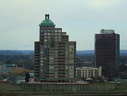
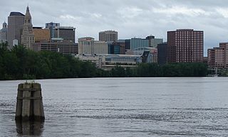
Hartford is the capital city of the U.S. state of Connecticut. The city, located in Hartford County, had a population of 121,054 as of the 2020 census. Hartford is the most populous city in the Capitol Planning Region and the core city of the Greater Hartford metropolitan area.

<span class="mw-page-title-main">Enfield, Connecticut</span> Town in Connecticut, United States

Enfield is a town in Hartford County, Connecticut, United States, first settled by John and Robert Pease of Salem, Massachusetts Bay Colony. The town is part of the Capitol Planning Region. The population was 42,141 at the 2020 census. It is bordered by Longmeadow, Massachusetts, and East Longmeadow, Massachusetts, to the north, Somers to the east, East Windsor and Ellington to the south, and the Connecticut River to the west.

<span class="mw-page-title-main">Manchester, Connecticut</span> Town in Connecticut, United States

Manchester is a town in Hartford County, Connecticut, United States. The town is part of the Capitol Planning Region. As of the 2020 census, the town had a total population of 59,713. The urban center of the town is the Manchester census-designated place, with a population of 36,379 at the 2020 census. The town is named after Manchester, in England.

<span class="mw-page-title-main">South Windsor, Connecticut</span> Town in Connecticut, United States

South Windsor is a town in Hartford County, Connecticut, United States. The town is part of the Capitol Planning Region. The population was 26,918 at the 2020 census.

<span class="mw-page-title-main">Greater Hartford</span> Metropolitan Statistical Area in Connecticut, United States

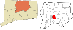
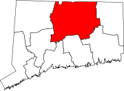
Greater Hartford is a region located in the U.S. state of Connecticut, centered on the state's capital of Hartford. It represents the only combined statistical area in Connecticut defined by a city within the state, being bordered by the Greater Boston region to the northeast and New York metropolitan area to the south and west. Sitting at the southern end of the Metacomet Ridge, its geology is characterized by land of a level grade along the shores of Connecticut River Valley, with loamy, finer-grained soil than other regions in the state. Greater Hartford, had a total population of 1,213,531 at the 2020 United States census.

<span class="mw-page-title-main">Frederick Rentschler</span> American aerospace engineer and executive (1887–1956)

Frederick Brant Rentschler was an American aircraft engine designer, aviation engineer, industrialist, and the founder of Pratt & Whitney Aircraft. Rentschler created and manufactured many revolutionary aircraft engines, including those used in the aircraft of Charles Lindbergh, Amelia Earhart and James Doolittle. He is also a co-founder of United Aircraft and Transport Corporation, the predecessor of United Technologies Corporation.

<span class="mw-page-title-main">Pratt & Whitney Stadium at Rentschler Field</span> Football stadium in East Hartford, Connecticut

Pratt & Whitney Stadium at Rentschler Field is a stadium in East Hartford, Connecticut. It is primarily used for football and soccer, and is the home field of the University of Connecticut (UConn) Huskies. In 2010, it was home to the Hartford Colonials of the United Football League. The stadium, which opened in 2003, was the first stadium used primarily by an NCAA Division I-A team to open in the 21st century. The permanent stadium capacity is 40,000, consisting of 38,066 permanent seats with a standing-room area in the scoreboard plaza that can accommodate up to 1,934 people. It also has a game day capability to add approximately 3,000 temporary seats as it did for UConn football vs. Michigan in 2013. Connecticut played on campus at Memorial Stadium in Storrs, before 2003.

<span class="mw-page-title-main">Podunk</span> Term that describes an insignificant location

The terms podunk and Podunk Hollow in American English denote or describe an insignificant, out-of-the-way, or even completely fictitious town. These terms are often used in the upper case as a placeholder name, to indicate "insignificance" and "lack of importance".

<span class="mw-page-title-main">Mayberry Village</span> Area in east central East Hartford, Connecticut

Mayberry Village is an area in east central East Hartford, Connecticut, United States. The neighborhood was originally developed in the 1940s to house the influx of people who worked at Pratt and Whitney and other defense industries in Connecticut. It is roughly bounded by Burnside Avenue to the north and Wilbur Cross Highway the south. To the east is the Hockanum River, across from which is Wickham Park, mostly in Manchester.

The Podunk were a Native American people who spoke an Algonquian Quiripi language and lived primarily in what is now known as Hartford County, Connecticut, United States. English colonists adopted use of a Nipmuc dialect word for the territory of this people.

<span class="mw-page-title-main">Rentschler Field</span> Airport in East Hartford, Connecticut

Rentschler Field was an airport in East Hartford, Connecticut in use from 1933 to 1999. Originally a military facility, later a private corporate airport, it was decommissioned in 1999, after which the football stadium of the same name was built on the site. On November 22, 2021 it was announced that the undeveloped remainder of Rentschler Field, was acquired from Raytheon Technologies by Massachusetts development firm National Development. The property will offer businesses more than 280 acres for development. Terms of the deal were not disclosed. From 1930 to 1939, the Chance Vought Aircraft Corporations's manufacturing facility was located here, as was the Pratt & Whitney Aircraft Company and the Hamilton Standard Propellers Corporation.

The 2016 UConn Huskies football team represented the University of Connecticut during the 2016 NCAA Division I FBS football season as a member of the East Division of the American Athletic Conference. They played their home games at Rentschler Field. They were led by third-year head coach Bob Diaco. They finished the season 3–9, 1–7 in American Athletic play to finish in a three way tie for fourth place in the East Division.

The 2017 UConn Huskies football team represented the University of Connecticut during the 2017 NCAA Division I FBS football season as a member of the East Division of the American Athletic Conference. They played their home games at Rentschler Field. They were led by head coach Randy Edsall in his first year of his second stint and thirteenth year overall. They finished the season 3–9, 2–6 in AAC play to finish in a three-way tie for fourth place in the East Division.

The 2018 UConn Huskies football team represented the University of Connecticut during the 2018 NCAA Division I FBS football season as a member of the East Division of the American Athletic Conference. They played their home games at Rentschler Field. They were led by head coach Randy Edsall in his second year of his second stint and 14th year overall. They finished the season 1–11, 0–8 in AAC play to finish in last in the East Division. They set the single-season FBS record for most yards and most points allowed in a single season. This included giving up 50.42 points per game and allowed 617.4 yards per game.

The 2019 UConn Huskies football team represented the University of Connecticut (UConn) during the 2019 NCAA Division I FBS football season. The Huskies were led by head coach Randy Edsall, who was in the third year of his second stint as head coach at the school. The team played their home games at Rentschler Field in East Hartford, Connecticut, and competed as members of the East Division of the American Athletic Conference. They finished the season 2–10, 0–8 in AAC play to finish in last place in the East Division. The 2019 season was the Huskies' last as members of the AAC.

The 2021 UConn Huskies football team represented the University of Connecticut (UConn) in the 2021 NCAA Division I FBS football season. The Huskies competed as an independent, having left the American Athletic Conference following the 2019 season. They played their home games at Rentschler Field in East Hartford, Connecticut.

The 2022 UConn Huskies football team represented the University of Connecticut (UConn) in the 2022 NCAA Division I FBS football season. The Huskies played their home games at Pratt & Whitney Stadium at Rentschler Field in East Hartford, Connecticut, and competed as an FBS independent. They were led by first-year head coach Jim L. Mora.

The 2023 UConn Huskies football team represented the University of Connecticut (UConn) in the 2023 NCAA Division I FBS football season. The Huskies were led by second-year head coach Jim L. Mora and played home games at the Pratt & Whitney Stadium at Rentschler Field in East Hartford, Connecticut.

The 2024 UConn Huskies football team will represent the University of Connecticut (UConn) as an independent during the 2024 NCAA Division I FBS football season. The Huskies are led by Jim L. Mora in his third year as the head coach. The Huskies will play home games at Pratt & Whitney Stadium at Rentschler Field, located in East Hartford, Connecticut.

References

  1. 1 2 U.S. Geological Survey Geographic Names Information System: East Hartford, Connecticut
  2. Stuart, Christine (August 13, 2021). "Census Data Shows Shifts In Connecticut's Demographics". CT News Junkie. Retrieved August 13, 2021.
  3. "Census - Geography Profile: East Hartford town, Hartford County, Connecticut". United States Census Bureau . Retrieved December 15, 2021.
  4. 1 2 "Geographic Identifiers: 2010 Demographic Profile Data (G001): East Hartford town, Hartford County, Connecticut". U.S. Census Bureau, American Factfinder. Archived from the original on February 12, 2020. Retrieved November 26, 2012.
  5. 1 2 3 Goodwin, Joseph Olcott (1879). East Hartford: Its History and Traditions. Hartford, Connecticut: Case, Lockwood, and Brainard Co.
  6. Burnham, Roderick Henry (1869). The Burnham Family; Or Genealogical Records of the Descendants of the Four. Hartford, Connecticut: Case, Lockwood, and Brainard Co.
  7. "East Hartford". ConnecticutHistory.org. Retrieved September 6, 2019.
  8. Paquette, Lee (1976). Only More So: The History of East Hartford, 1783-1976. East Hartford, CT: Raymond Library Company. pp. 142, 205, 209.
  9. "May 24, 1931: 'Original' Rentschler Field Dedicated". United Technologies. Retrieved September 7, 2019.
  10. Rent Being Renamed Pratt & Whitney Stadium At Rentschler Field
  11. "Station: EAST HARTFORD 1.3 E, CT US US1CTHR0022" (PDF). Summary of Monthly Normals 1991-2020. NOAA. p. 1. Retrieved May 16, 2024.
  12. "Time Series Values for Individual Locations". prism.oregonstate.edu. Oregon State University: Northwest Alliance for Computational Science & Engineering. Retrieved May 16, 2024. Latitude: 41.7824 Longitude: -72.6211 Elevation: 14m (46ft)
  13. "U.S. Census website". United States Census Bureau . Retrieved September 4, 2020.
  14. "East Hartford, CT Population - Census 2010 and 2000 Interactive Map, Demographics, Statistics, Quick Facts - CensusViewer". censusviewer.com. Retrieved September 13, 2020.
  15. Villanova, Joseph (November 9, 2021). "Walsh sworn in as East Hartford's new mayor". Journal Inquirer. Retrieved September 8, 2022.
  16. Branciforte, Anthony (February 5, 2021). "East Hartford's Mayor Leclerc won't seek re-election this year". www.journalinquirer.com/. Journal Inquirer. Retrieved September 8, 2022.
  17. "General Elections Statement of Vote 1922".
  18. "Registration and Party Enrollment Statistics as of October 30, 2007" (PDF). Connecticut Secretary of State. Archived from the original (PDF) on February 1, 2015. Retrieved September 18, 2008.
  19. "Contact Us Archived 2011-03-19 at the Wayback Machine ." Pratt & Whitney. Retrieved on January 7, 2011. "Corporate Headquarters Pratt & Whitney 400 Main Street East Hartford, CT 06108."
  20. Chen, Xiangming and John Shemo. 2013. “Shifting Fortunes: Hartford’s Global and Regional Economic Dimensions.” Pp. 193-218 in Confronting Urban Legacy: Rediscovering Hartford and New England's Forgotten Cities. Xiangming Chen and Nick Bacon (eds). Lanham, MD: Lexington Books.
  21. Bacon, Nick. 2013. “Podunk after Pratt: Place and Placelessness in East Hartford, CT.” Pp. 46-64 in Confronting Urban Legacy: Rediscovering Hartford and New England's Forgotten Cities. Xiangming Chen and Nick Bacon (eds). Lanham, MD: Lexington Books.
  22. "Town of East Hartford Comprehensive Annual Financial Report Year Ended June 30, 2023" (PDF). Town of East Hartford. Retrieved March 6, 2024.
  23. "Great River Park | Riverfront Recapture". www.riverfront.org. Retrieved May 22, 2017.
  24. "Wickham Park, Manchester Connecticut". www.wickhampark.org. Retrieved May 22, 2017.
  25. "PRATT & WHITNEY STADIUM AT RENTSCHLER FIELD". UConn Athletics. Retrieved July 20, 2021.