Hinsdale, New Hampshire

Last updated

Hinsdale, New Hampshire
Town
HinsdaleNH TownHall.jpg
Town Hall
Hinsdale Town Seal.png
Cheshire-Hinsdale-NH.png
Coordinates: 42°47′10″N72°29′11″W / 42.78611°N 72.48639°W / 42.78611; -72.48639
Country United States
State New Hampshire
County Cheshire
Incorporated 1753
Villages
Government
   Board of Selectmen
  • Steve Diorio, Chair
  • Richard Johnson
  • Bernie Rideout
  • Michael Carrier
  • William Hodgman
  Town AdministratorKathryn Lynch
Area
[1]
  Total22.7 sq mi (58.7 km2)
  Land20.5 sq mi (53.1 km2)
  Water2.1 sq mi (5.5 km2)  9.42%
Elevation
217 ft (66 m)
Population
 (2020) [2]
  Total3,948
  Density192/sq mi (74.3/km2)
Time zone UTC-5 (Eastern)
  Summer (DST) UTC-4 (Eastern)
ZIP code
03451
Area code 603
FIPS code 33-36660
GNIS feature ID0873626
Website www.town.hinsdale.nh.us

Hinsdale is a town in Cheshire County, New Hampshire, United States. The population was 3,948 at the 2020 census. [2] Hinsdale is home to part of Pisgah State Park in the northeast, and part of Wantastiquet Mountain State Forest in the northwest.

Contents

The main village in town, where 1,485 people resided at the 2020 census, is defined as the Hinsdale census-designated place (CDP) and is located at the junction of New Hampshire routes 119 and 63.

History

Located in the southwestern corner of the state, Hinsdale was chartered in 1753. It was named for Colonel Ebenezer Hinsdale, [3] member of a prominent Deerfield, Massachusetts, family, whose mother had been taken captive in the famed Raid on Deerfield of 1704. Graduated from Harvard, Hinsdale was ordained to become a missionary for Indians of the Connecticut River Valley. Instead, he would serve as chaplain at Fort Dummer, an important trading post on the Connecticut River, later enlisting as an officer in the army. Then, in 1742, he established Fort Hinsdale, including a trading post and gristmill, reportedly at his own expense. The town's earliest history recounts Indian assaults, raids and captivities. [4]

Located beside the Connecticut River and connected to Brattleboro, Vermont, by bridge, Hinsdale contains excellent farmland, but has been a significant center of industry as well, especially in the manufacture of paper. In a machine shop here, George A. Long built a self-propelled steam vehicle in 1875, the Long steam tricycle, for which he received one of the nation's earliest automobile patents. The Hinsdale post office, located on Main Street, is the oldest continually-operating in the same building post office in the United States. [5]

From 1959 to 2008, the town was home to the Hinsdale Greyhound Park. [6] In 2023, Geoffrey Holt, a caretaker of a mobile home park, left the town $3.8 million to be used for education, health, recreation, and culture. [7]

Geography

Hinsdale is in the southwestern corner of New Hampshire, bordered to the west across the Connecticut River by Vermont and to the south by Massachusetts. According to the United States Census Bureau, the town has a total area of 22.7 square miles (58.7 km2), of which 20.5 square miles (53.1 km2) are land and 2.1 square miles (5.5 km2) are water, comprising 9.42% of the town. [1]

The highest point in town is Wantastiquet Mountain, at 1,378 feet (420 m) above sea level, located on the town's northern boundary and overlooking the Connecticut River and Brattleboro, Vermont, to the west. The entire town lies within the Connecticut River watershed, with roughly the northwestern two-thirds of town draining into small streams that feed directly into the Connecticut, and with the southeastern third of the town draining into the Ashuelot River, a major tributary of the Connecticut. [8]

Hinsdale is served by state routes 63 and 119.

Adjacent municipalities

Demographics

Historical population
CensusPop.Note
1790 522
1800 63421.5%
1810 74016.7%
1820 89020.3%
1830 9375.3%
1840 1,14121.8%
1850 1,96372.0%
1860 1,312−33.2%
1870 1,3422.3%
1880 1,86839.2%
1890 2,25820.9%
1900 1,933−14.4%
1910 1,673−13.5%
1920 1,7736.0%
1930 1,757−0.9%
1940 1,7620.3%
1950 1,95010.7%
1960 2,18712.2%
1970 3,27649.8%
1980 3,63110.8%
1990 3,9368.4%
2000 4,0823.7%
2010 4,046−0.9%
2020 3,948−2.4%
U.S. Decennial Census [2] [9]

As of the census of 2010, there were 4,046 people, 1,681 households, and 1,093 families residing in the town. There were 1,827 housing units, of which 146, or 8.0%, were vacant. The racial makeup of the town was 96.5% white, 0.5% African American, 0.2% Native American, 0.5% Asian, 0.3% Native Hawaiian or Pacific Islander, 0.3% some other race, and 1.6% from two or more races. 1.4% of the population were Hispanic or Latino of any race. [10]

Of the 1,681 households, 29.6% had children under the age of 18 living with them, 48.5% were headed by married couples living together, 10.8% had a female householder with no husband present, and 35.0% were non-families. 26.2% of all households were made up of individuals, and 10.8% were someone living alone who was 65 years of age or older. The average household size was 2.41, and the average family size was 2.85. [10]

In the town, 21.2% of the population were under the age of 18, 8.2% were from 18 to 24, 23.9% from 25 to 44, 32.1% from 45 to 64, and 14.4% were 65 years of age or older. The median age was 42.7 years. For every 100 females, there were 99.8 males. For every 100 females age 18 and over, there were 96.5 males. [10]

For the period 2011–2015, the estimated median annual income for a household was $50,217, and the median income for a family was $54,966. Male full-time workers had a median income of $42,781 versus $40,377 for females. The per capita income for the town was $23,995. 10.2% of the population and 4.7% of families were below the poverty line. 7.1% of the population under the age of 18 and 15.6% of those 65 or older were living in poverty. [11]

Notable people

Scene at Brightwood Mills in 1908 Brightwood Mills, Hinsdale, NH.jpg
Scene at Brightwood Mills in 1908

Related Research Articles

<span class="mw-page-title-main">Windham County, Vermont</span> County in Vermont, United States

Windham County is a county located in the U.S. state of Vermont. As of the 2020 census, the population was 45,905. The shire town is Newfane, and the largest municipality is the town of Brattleboro.

<span class="mw-page-title-main">Cheshire County, New Hampshire</span> County in New Hampshire, United States

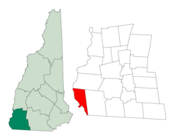
Cheshire County is a county in the southwestern corner of the U.S. state of New Hampshire. As of the 2020 census, the population was 76,458. Its county seat is the city of Keene. Cheshire was one of the five original counties of New Hampshire, and is named for the county of Cheshire in England. It was organized in 1771 at Keene. Sullivan County was created from the northern portion of Cheshire County in 1827.

<span class="mw-page-title-main">Hinsdale, Massachusetts</span> Town in Massachusetts, United States

Hinsdale is a town in Berkshire County, Massachusetts, United States. It is part of the Metropolitan Statistical Area of Pittsfield, Massachusetts. The population was 1,919 at the 2020 census.

<span class="mw-page-title-main">Peru, Massachusetts</span> Town in Massachusetts, United States

Peru is a town in Berkshire County, Massachusetts, United States. The population was 814 at the 2020 census.

<span class="mw-page-title-main">Warwick, Massachusetts</span> Town in Massachusetts, United States

Warwick is a town in Franklin County, Massachusetts, United States. The population was 780 at the 2020 census. It is part of the Springfield, Massachusetts Metropolitan Statistical Area.

<span class="mw-page-title-main">Chesterfield, New Hampshire</span> Town in New Hampshire, United States

Chesterfield is a town in Cheshire County, New Hampshire, United States. The population was 3,552 at the 2020 census. It includes the villages of Spofford and West Chesterfield. Chesterfield is home to Spofford Lake, Chesterfield Gorge Natural Area, and parts of Pisgah State Park and Wantastiquet Mountain State Forest.

<span class="mw-page-title-main">Walpole, New Hampshire</span> Town in New Hampshire, United States

Walpole is a town in Cheshire County, New Hampshire, United States. The population was 3,633 at the 2020 census.

<span class="mw-page-title-main">Westmoreland, New Hampshire</span> Town in New Hampshire, United States

Westmoreland is a town in Cheshire County, New Hampshire, United States. The population was 1,706 at the 2020 census, down from 1,874 at the 2010 census. Westmoreland is historically an agricultural town, with much arable farmland.

<span class="mw-page-title-main">Fairlee, Vermont</span> Town in Vermont, United States

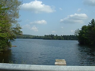
Fairlee is a town in Orange County, Vermont, United States. The population was 988 at the 2020 census. It includes the village of Ely. Fairlee is home to Lake Morey, which claims to have the longest ice skating trail in the United States.

<span class="mw-page-title-main">Dummerston, Vermont</span> Town in Vermont, United States

Dummerston is a town in Windham County, Vermont, United States. The population was 1,865 at the 2020 census. It is home to the longest covered bridge still in use in Vermont. Its borders include three main villages: Dummerston Center, West Dummerston, and East Dummerston.

<span class="mw-page-title-main">Vernon, Vermont</span> Town in Vermont, United States

Vernon is a town in Windham County, Vermont, in the United States. The population was 2,192 at the 2020 census. Vernon is the site of the now-defunct Vermont Yankee, the state of Vermont's only nuclear power plant, which closed in December 2014.

<span class="mw-page-title-main">Northfield, Massachusetts</span> Town in Massachusetts, United States

Northfield is a town in Franklin County, Massachusetts, United States. Northfield was first settled in 1673. The population was 2,866 at the 2020 census. It is part of the Springfield, Massachusetts Metropolitan Statistical Area. The Connecticut River runs through the town, dividing West Northfield from East Northfield and the village of Northfield, where the town hall is located.

<span class="mw-page-title-main">Hinsdale (CDP), New Hampshire</span> Census-designated place in New Hampshire, United States

Hinsdale is a census-designated place (CDP) and the main village in the town of Hinsdale in Cheshire County, New Hampshire, United States. The population of the CDP was 1,485 at the 2020 census, out of 3,948 in the entire town of Hinsdale.

<span class="mw-page-title-main">Winchester (CDP), New Hampshire</span> Census-designated place in New Hampshire, United States

Winchester is a census-designated place (CDP) and the main village in the town of Winchester in Cheshire County, New Hampshire, United States. The population of the CDP was 1,606 at the 2020 census, compared to 4,150 in the entire town.

<span class="mw-page-title-main">Winchester, New Hampshire</span> Town in New Hampshire, United States

Winchester is a town in Cheshire County, New Hampshire, United States. The population was 4,150 at the 2020 census. The primary community in the town, where 1,606 people resided at the 2020 census, is defined by the U.S. Census Bureau as the Winchester census-designated place (CDP). The town also includes the village of Ashuelot and part of Pisgah State Park.

<span class="mw-page-title-main">Charlestown (CDP), New Hampshire</span> Census-designated place in New Hampshire, United States

Charlestown is a census-designated place (CDP) and the main village in the town of Charlestown, Sullivan County, New Hampshire, United States. The population of the CDP was 1,078 at the 2020 census, out of 4,806 in the entire town.

<span class="mw-page-title-main">Charlestown, New Hampshire</span> Place in New Hampshire, United States

Charlestown is a town in Sullivan County, New Hampshire, United States. The population was 4,806 at the 2020 census, down from 5,114 at the 2010 census. The town is home to Hubbard State Forest and the headquarters of the Student Conservation Association.

<span class="mw-page-title-main">Brattleboro, Vermont</span> Town in Vermont, United States

Brattleboro, originally Brattleborough, is a town in Windham County, Vermont, United States, located about 10 miles (16 km) north of the Massachusetts state line at the confluence of Vermont's West River and Connecticut. With a 2022 Census population of 12,106, it is the most populous municipality abutting Vermont's eastern border with New Hampshire, which is the Connecticut River.

<span class="mw-page-title-main">Westminster (town), Vermont</span> Town in Vermont, United States

Westminster is a town in Windham County, Vermont, United States. The population was 3,016 at the 2020 census. It is also the first capital of the Republic of Vermont. It borders the state of New Hampshire.

<span class="mw-page-title-main">New Hampshire Route 119</span> Highway in New Hampshire

New Hampshire Route 119 is a state highway in the U.S. state of New Hampshire. The highway begins in Hinsdale at the Connecticut River, across which the highway continues into Brattleboro, Vermont, as Vermont Route 119 for 0.080 miles (0.129 km) to its terminus at U.S. Route 5 and VT 142. NH 119 heads east 39.908 miles (64.226 km) to the Massachusetts state line in New Ipswich, where the highway continues as Massachusetts Route 119. The state highway is the main east–west highway of southern Cheshire County, where it connects the towns of Hinsdale, Winchester, Richmond, Fitzwilliam, and Rindge.

References

  1. 1 2 "2021 U.S. Gazetteer Files – New Hampshire". United States Census Bureau. Retrieved November 3, 2021.
  2. 1 2 3 "Hinsdale town, Cheshire County, New Hampshire: 2020 DEC Redistricting Data (PL 94-171)". U.S. Census Bureau. Retrieved November 3, 2021.
  3. Gannett, Henry (1905). The Origin of Certain Place Names in the United States. Govt. Print. Off. p. 157.
  4. Coolidge, Austin J.; John B. Mansfield (1859). A History and Description of New England. Boston, Massachusetts. pp. 527–529.{{cite book}}: CS1 maint: location missing publisher (link)
  5. "Oldest Post Office (in the same building)". Postal Facts. United States Postal Service . Retrieved November 27, 2023.
  6. Brown, Garry (December 29, 2008). "Western Mass. fans regret passing of nearby greyhound race track". The Springfield Republican . Retrieved October 10, 2012.
  7. McCornack, Kathy; Bukaty, Robert T. (November 21, 2023). "New Hampshire man had no car and no furniture, but died with a big secret, leaving his town millions". The Boston Globe. The Associated Press. Retrieved November 21, 2023.
  8. Foster, Debra H.; Batorfalvy, Tatianna N.; Medalie, Laura (1995). Water Use in New Hampshire: An Activities Guide for Teachers. U.S. Department of the Interior and U.S. Geological Survey.
  9. "Census of Population and Housing". Census.gov. Retrieved June 4, 2016.
  10. 1 2 3 "Profile of General Population and Housing Characteristics: 2010 Census Summary File 1 (DP-1): Hinsdale town, Cheshire County, New Hampshire". U.S. Census Bureau, American Factfinder. Archived from the original on February 13, 2020. Retrieved October 26, 2017.
  11. "Selected Economic Characteristics: 2011-2015 American Community Survey 5-Year Estimates (DP03): Hinsdale town, Cheshire County, New Hampshire". U.S. Census Bureau, American Factfinder. Archived from the original on February 13, 2020. Retrieved October 26, 2017.
  12. Symons, Caleb (April 10, 2021). "Hinsdale diplomat travels the world — and up the State Dept. Ranks". The Keene Sentinel. Retrieved March 16, 2023.
  13. "Who is Joey Hood? New US Ambassador to Tunisia". Tunisian Monitor Online. December 23, 2022.[ dead link ]