Jaffrey, New Hampshire

Last updated

Jaffrey, New Hampshire
Town
JaffreyLibrary.JPG
Clay Memorial Library, listed on the National Register of Historic Places [2]
Jaffrey, NH Town Seal.png
Cheshire-Jaffrey-NH.png
Coordinates: 42°48′50″N72°01′23″W / 42.81389°N 72.02306°W / 42.81389; -72.02306
CountryUnited States
State New Hampshire
County Cheshire
Incorporated 1773
Villages
Government
   Select Board
  • Franklin W. Sterling, Chair
  • Kevin Chamberlain
  • Charlie Turcotte
  Town ManagerJon Frederick
Area
[3]
  Total40.2 sq mi (104.1 km2)
  Land38.4 sq mi (99.5 km2)
  Water1.8 sq mi (4.6 km2)  4.42%
Elevation
991 ft (302 m)
Population
 (2020) [4]
  Total5,320
  Density139/sq mi (53.5/km2)
Time zone UTC-5 (Eastern)
  Summer (DST) UTC-4 (Eastern)
ZIP code
03452
Area code 603
FIPS code 33-38500
GNIS feature ID0873633
Website www.townofjaffrey.com

Jaffrey is a town in Cheshire County, New Hampshire, United States. The population was 5,320 at the 2020 census. [4]

Contents

The main village in town, where 3,058 people resided at the 2020 census, is defined as the Jaffrey census-designated place (CDP) and is located along the Contoocook River at the junction of U.S. Route 202 and New Hampshire routes 124 and 137.

History

First granted by the Massachusetts General Court in 1736 to soldiers from Rowley, Massachusetts, returning from the war in Canada, the town was known as "Rowley-Canada". In 1749, the town was re-chartered by the Mason proprietors as "Monadnock No. 2", sometimes called "Middle Monadnock" or "Middletown". [5] It was one of the first towns established following the Masonian proprietors' purchase of undivided lands under the claim.

Settled about 1758, [6] the town was regranted in 1767. It was incorporated in 1773 by Governor John Wentworth and named for George Jaffrey, member of a wealthy Portsmouth family. [5] Jaffrey's son was a life trustee of Dartmouth College and designer of the official college seal. The Contoocook River provided water power for mills. Village prosperity would be expressed in fine early architecture, including the Town Meetinghouse, built in 1775.

Beginning in the 1840s, the area's scenic beauty attracted tourists, and several summer hotels were built at the base of Mount Monadnock, enduringly popular with hikers. Some who scaled the summit were Ralph Waldo Emerson, Henry David Thoreau and Rudyard Kipling. The experience inspired Emerson in 1845 to write the poem, Monadnoc.

Jaffrey was the setting for a 1950 biography by Elizabeth Yates entitled Amos Fortune, Free Man, winner of the 1951 Newbery Medal. Amos Fortune was an African-born slave who purchased his freedom and that of his wife, and established a tannery in the village. He is buried in the local cemetery, as are bandbox craftswoman Hannah Davis and author and summer resident Willa Cather.

Jaffrey was the inspiration for a chapter in Parliament of Whores by P. J. O'Rourke, who was a resident for several years.

Geography

According to the United States Census Bureau, the town has a total area of 40.2 square miles (104.1 km2), of which 38.4 square miles (99.5 km2) are land and 1.8 square miles (4.6 km2) are water, comprising 4.42% of the town. [3] Jaffrey village is in the eastern part of the town, and the smaller village of Jaffrey Center is near the town center.

Thorndike Pond is in the north, and Contoocook Lake is on the southern boundary. Mount Monadnock, elevation 3,165 feet (965 m) and the highest point in Jaffrey as well as Cheshire County, is in the northwest. Jaffrey lies mostly within the Merrimack River watershed, via the Contoocook River in the eastern part of the town, with the northwest corner of town lying in the Ashuelot River watershed, part of the larger Connecticut River watershed. [7]

Adjacent municipalities

Demographics

Historical population
CensusPop.Note
1790 1,235
1800 1,3418.6%
1810 1,336−0.4%
1820 1,3390.2%
1830 1,3541.1%
1840 1,4114.2%
1850 1,4976.1%
1860 1,453−2.9%
1870 1,256−13.6%
1880 1,2670.9%
1890 1,46915.9%
1900 1,80122.6%
1910 1,8955.2%
1920 2,30321.5%
1930 2,4857.9%
1940 2,87915.9%
1950 2,9111.1%
1960 3,1548.3%
1970 3,3536.3%
1980 4,34929.7%
1990 5,36123.3%
2000 5,4762.1%
2010 5,457−0.3%
2020 5,320−2.5%
U.S. Decennial Census [4] [8]

As of the census of 2010, there were 5,457 people, 2,234 households, and 1,451 families residing in the town. There were 2,547 housing units, of which 313, or 12.3%, were vacant. 160 of the vacant units were for seasonal or recreational use. The racial makeup of the town was 96.2% white, 0.4% African American, 0.2% Native American, 1.2% Asian, 0.04% Native Hawaiian or Pacific Islander, 0.3% some other race, and 1.7% from two or more races. 1.6% of the population were Hispanic or Latino of any race. [9]

Of the 2,234 households, 30.9% had children under the age of 18 living with them, 48.4% were headed by married couples living together, 11.1% had a female householder with no husband present, and 35.0% were non-families. 28.6% of all households were made up of individuals, and 10.5% were someone living alone who was 65 years of age or older. The average household size was 2.41, and the average family size was 2.95. [9]

In the town, 24.0% of the population were under the age of 18, 7.8% were from 18 to 24, 23.2% from 25 to 44, 29.6% from 45 to 64, and 15.3% were 65 years of age or older. The median age was 41.5 years. For every 100 females, there were 93.5 males. For every 100 females age 18 and over, there were 91.4 males. [9]

For the period 2011–2015, the estimated median annual income for a household was $56,618, and the median income for a family was $73,564. Male full-time workers had a median income of $50,138 versus $39,434 for females. The per capita income for the town was $27,689. 15.0% of the population and 6.5% of families were below the poverty line. 28.3% of the population under the age of 18 and 15.9% of those 65 or older were living in poverty. [10]

School system

Jaffrey, along with the town of Rindge, forms the Jaffrey-Rindge Cooperative School District, also known as SAU 47. The public schools in the town are Jaffrey Grade School (grades PK–5), and Conant Middle High School (6–12). There is also a private high school, Victory High School (9–12).

Notable people

Related Research Articles

<span class="mw-page-title-main">Cheshire County, New Hampshire</span> County in New Hampshire, United States

Cheshire County is a county in the southwestern corner of the U.S. state of New Hampshire. As of the 2020 census, the population was 76,458. Its county seat is the city of Keene. Cheshire was one of the five original counties of New Hampshire, and is named for the county of Cheshire in England. It was organized in 1771 at Keene. Sullivan County was created from the northern portion of Cheshire County in 1827.

<span class="mw-page-title-main">Dublin, New Hampshire</span> Town in New Hampshire, United States

Dublin is a town in Cheshire County, New Hampshire, United States. The population was 1,532 at the 2020 census. It is home to Dublin School and Yankee magazine.

<span class="mw-page-title-main">Fitzwilliam, New Hampshire</span> Town in New Hampshire, United States

Fitzwilliam is a town in Cheshire County, New Hampshire, United States. The population was 2,351 at the 2020 census. Fitzwilliam is home to Rhododendron State Park, a 16-acre (6.5 ha) grove of native rhododendrons that bloom in mid-July.

<span class="mw-page-title-main">Gilsum, New Hampshire</span> Town in New Hampshire, United States

Gilsum is a town in Cheshire County, New Hampshire, United States. The population was 752 at the 2020 census. Home to Bear's Den Natural Area, Gilsum includes Gilsum Lower Village.

<span class="mw-page-title-main">Harrisville, New Hampshire</span> Town in New Hampshire, United States

Harrisville is a town in Cheshire County, New Hampshire, United States. Besides the town center, it also includes the villages of Chesham and Eastview. The population of the town was 984 at the 2020 census.

<span class="mw-page-title-main">Nelson, New Hampshire</span> Town in New Hampshire, United States

Nelson is a town in Cheshire County, New Hampshire, United States. The population was 629 at the 2020 census, down from 729 at the 2010 census. Nelson includes the village of Munsonville.

<span class="mw-page-title-main">Rindge, New Hampshire</span> Town in New Hampshire, United States

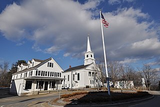
Rindge is a town in Cheshire County, New Hampshire, United States. The population was 6,476 at the 2020 census, up from 6,014 at the 2010 census. Rindge is home to Franklin Pierce University, the Cathedral of the Pines and part of Annett State Forest.

<span class="mw-page-title-main">Sullivan, New Hampshire</span> Town in New Hampshire, United States

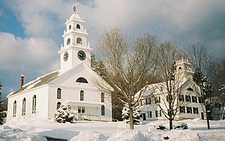
Sullivan is a town in Cheshire County, New Hampshire, United States. The population was 658 at the 2020 census. It includes the villages of East Sullivan and Ellisville.

<span class="mw-page-title-main">Troy, New Hampshire</span> Town in New Hampshire, United States

Troy is a town in Cheshire County, New Hampshire, United States. The population was 2,130 at the 2020 census. It is situated west of Mount Monadnock.

<span class="mw-page-title-main">Bennington, New Hampshire</span> Town in New Hampshire, United States

Bennington is a town in Hillsborough County, New Hampshire, United States. The population was 1,501 at the 2020 census.

<span class="mw-page-title-main">Greenfield, New Hampshire</span> Town in New Hampshire, United States

Greenfield is a town in Hillsborough County, New Hampshire, United States. The population was 1,716 at the 2020 census. Greenfield is home to the Crotched Mountain Rehabilitation Center, to Greenfield State Park, and to part of the Wapack Trail.

<span class="mw-page-title-main">Sharon, New Hampshire</span> Town in New Hampshire, United States

Sharon is a town in Hillsborough County, New Hampshire, United States. The population was 359 at the 2020 census. It was the long-time home to the Sharon Arts Center, a nonprofit which has ceased operations.

<span class="mw-page-title-main">Salisbury, New Hampshire</span> Town in New Hampshire, United States

Salisbury is a town in Merrimack County, New Hampshire, United States. The population was 1,422 at the 2020 census.

<span class="mw-page-title-main">Sutton, New Hampshire</span> Town in New Hampshire, United States

Sutton is a town in Merrimack County, New Hampshire, United States. The population was 1,978 at the 2020 census. Sutton includes the villages of Sutton Mills, North Sutton, South Sutton and East Sutton. North Sutton is home to Wadleigh State Park on Kezar Lake.

<span class="mw-page-title-main">Washington, New Hampshire</span> Place in New Hampshire, United States

Washington is a town in Sullivan County, New Hampshire, United States. The population was 1,192 at the 2020 census. Situated in a hilly, rocky, forested area, and with 26 lakes and ponds, Washington is a picturesque resort area. It is home to Pillsbury State Park.

<span class="mw-page-title-main">Jaffrey (CDP), New Hampshire</span> Census-designated place in New Hampshire, United States

Jaffrey is a census-designated place (CDP) and the main village in the town of Jaffrey in Cheshire County, New Hampshire, United States. The population of the CDP was 3,058 at the 2020 census, out of 5,320 in the entire town of Jaffrey.

<span class="mw-page-title-main">Marlborough, New Hampshire</span> Town in New Hampshire, United States

Marlborough is a town in Cheshire County, New Hampshire, United States. The population was 2,096 at the 2020 census. The town is home to the Kensan-Devan Wildlife Sanctuary at Meetinghouse Pond.

<span class="mw-page-title-main">Winchester, New Hampshire</span> Town in New Hampshire, United States

Winchester is a town in Cheshire County, New Hampshire, United States. The population was 4,150 at the 2020 census. The primary community in the town, where 1,606 people resided at the 2020 census, is defined by the U.S. Census Bureau as the Winchester census-designated place (CDP). The town also includes the village of Ashuelot and part of Pisgah State Park.

<span class="mw-page-title-main">Henniker, New Hampshire</span> Town in New Hampshire, United States

Henniker is a town in Merrimack County, New Hampshire, United States. As of the 2020 census, the reported total population of the town was 6,185, although the figure, 27.9% greater than the 2010 population, has been questioned by local officials. Henniker is home to New England College and Pats Peak Ski Area. Henniker is a college town and resort area, featuring both skiing and white-water kayaking.

<span class="mw-page-title-main">Peterborough, New Hampshire</span> Town in New Hampshire, United States

Peterborough is a town in Hillsborough County, New Hampshire, United States. The population was 6,418 at the 2020 census. The main village, with 3,090 people at the 2020 census, is defined as the Peterborough census-designated place (CDP) and is located along the Contoocook River at the junction of U.S. Route 202 and New Hampshire Route 101. Peterborough is 38 miles (61 km) west of Manchester and 72 miles (116 km) northwest of Boston.

References

  1. "Clay Memorial Library in Jaffrey added to National Register of Historic Places" (Press release). New Hampshire Department of Natural and Cultural Resources. October 23, 2023. Retrieved October 31, 2023 via NH.gov.
  2. "Clay Memorial Library in Jaffrey added to National Register of Historic Places" (Press release). New Hampshire Department of Natural and Cultural Resources. October 23, 2023. Retrieved October 31, 2023 via NH.gov.
  3. 1 2 "2021 U.S. Gazetteer Files – New Hampshire". United States Census Bureau. Retrieved November 3, 2021.
  4. 1 2 3 "Jaffrey town, Cheshire County, New Hampshire: 2020 DEC Redistricting Data (PL 94-171)". U.S. Census Bureau. Retrieved November 3, 2021.
  5. 1 2 Coolidge, Austin J.; John B. Mansfield (1859). A History and Description of New England. Boston, Massachusetts: A.J. Coolidge. pp.  536–537. coolidge mansfield history description new england 1859.
  6. Cutter, Daniel B. (1881). History of the Town of Jaffrey: The Masonian Charter to the Present Time, 1749–1880. Concord, New Hampshire: Republican Press Association. p.  32.
  7. Foster, Debra H.; Batorfalvy, Tatianna N.; Medalie, Laura (1995). Water Use in New Hampshire: An Activities Guide for Teachers. U.S. Department of the Interior and U.S. Geological Survey.
  8. "Census of Population and Housing". Census.gov. Retrieved June 4, 2016.
  9. 1 2 3 "Profile of General Population and Housing Characteristics: 2010 Census Summary File 1 (DP-1): Jaffrey town, Cheshire County, New Hampshire". U.S. Census Bureau, American Factfinder. Archived from the original on February 13, 2020. Retrieved October 26, 2017.
  10. "Selected Economic Characteristics: 2011-2015 American Community Survey 5-Year Estimates (DP03): Jaffrey town, Cheshire County, New Hampshire". U.S. Census Bureau, American Factfinder. Archived from the original on February 13, 2020. Retrieved October 26, 2017.