
Washington County is a county located in the southeastern part of the U.S. state of Ohio. As of the 2020 census, the population was 59,711. Its county seat is Marietta. The county, the oldest in the state, is named for George Washington. Washington County comprises the Marietta, OH Micropolitan Statistical Area, which is also included in the Parkersburg-Marietta-Vienna, WV-OH Combined Statistical Area.
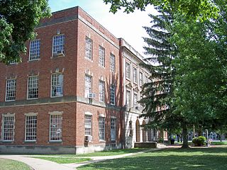
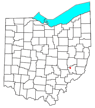
Noble County is a county located in the U.S. state of Ohio. As of the 2020 census, the population was 14,115, making it the fourth-least populous county in Ohio. Its county seat is Caldwell. The county is named for Rep. Warren P. Noble of the Ohio House of Representatives, who was an early settler there.

Muskingum County is a county located in the U.S. state of Ohio. As of the 2020 census, the population was 86,410. Its county seat is Zanesville. Nearly bisected by the Muskingum River, the county name is based on a Delaware American Indian word translated as "town by the river" or "elk's eye".

Highland County is a county located in the U.S. state of Ohio. As of the 2020 census, the population was 43,317. Its county seat is Hillsboro. The county is named for the topography which is hilly and divides the watersheds of the Little Miami and Scioto Rivers.

Tulpehocken Creek is a 39.5-mile-long (63.6 km) tributary of the Schuylkill River in southeastern Pennsylvania in the United States, and during the American Canal Age, once provided nearly half the length of the Union Canal linking the port of Philadelphia, the largest American city and the other communities of Delaware Valley with the Susquehanna basin and the Pennsylvania Canal System connecting the Eastern seaboard to Lake Erie and the new settlements of the Northwest Territory via the Allegheny, Monongahela, and Ohio Rivers at Pittsburgh.

Wayne Township is one of the thirteen townships of Clinton County, Ohio, United States. As of the 2020 census the population was 700.

Lees Creek, also known as Centerville, is an unincorporated community in central Wayne Township, Clinton County, Ohio, United States. It lies at the intersection of State Route 729 with Cox Road, 6 miles south of Sabina and 12 miles (19 km) southeast of Wilmington, the county seat of Clinton County. It lies between the headwaters of the Middle Fork of Lees Creek, to the southeast, and the Anderson Fork of Caesar Creek. it had a post office, with the ZIP code 45138. The Post Office closed in 2012 and the town, including East Clinton High School, now carries a Sabina mailing address.

Sugar Creek Township is one of the sixteen townships of Wayne County, Ohio, United States. The 2020 census found 7,187 people in the township.
Ava is an unincorporated community in northwestern Noble Township, Noble County, Ohio, United States. It has a post office with the ZIP code 43711. Another location in Ava is a small museum dedicated to the nearby crash of the airship USS Shenandoah in 1925.

Bartlett is an unincorporated community in southwestern Wesley Township, Washington County, Ohio, United States. It has a post office with the ZIP code 45713. It sits at the intersection of State Routes 550 and 555 near Coal Run, a subsidiary of Wolf Creek, which meets the Muskingum River at Waterford to the north. Near Bartlett is located the Shinn Covered Bridge, which spans Wolf Creek.

Cuyahoga County, Ohio, United States is divided into 21 townships.

Harriettsville is an unincorporated community in western Elk Township, Noble County, Ohio, United States. It lies along State Route 145 at its intersection with County Road 46. The East Fork of Duck Creek, a subsidiary of the Ohio River that meets the river near Marietta, runs along State Route 145 past the community. It lies 8 miles (13 km) northeast of Lower Salem by road, and 13 miles (21 km) directly southeast of Caldwell, the county seat of Noble County.

College Creek is located in James City County in the Virginia Peninsula area of the Hampton Roads region of southeastern Virginia in the United States. From a point of origin near the independent city of Williamsburg, it is a tributary of the James River.
Hollidays Cove is a neighborhood in Weirton, West Virginia, United States. Founded in 1793, Hollidays Cove was the earliest permanent white settlement in what was then Brooke County, Virginia, later becoming Hancock County, West Virginia. The settlement was named after John Holliday, who built a log cabin in a valley on Harmon's Creek in 1776.

Seneca is an unincorporated community in Montgomery County, Maryland, United States. It is located near the intersection of River Road and Seneca Creek, not far from the Chesapeake and Ohio Canal and Potomac River. Its history goes back before the American Revolutionary War and it thrived when the canal was operating—having several warehouses, mills, a store, a hotel, and a school. Fighting occurred in the area on more than one occasion during the American Civil War. The community declined as the C&O Canal declined.

Big Darby Creek is a scenic river located in northwestern central Ohio, and an important tributary to the Lower Scioto River. The river's major tributary is the Little Darby Creek.

Holy Rosary Catholic Church is a Roman Catholic parish on the east side of St. Marys, Ohio, United States. Established in 1852, the church has been recognized for its historic 1860s church building, which was demolished amid a period of growth in the 1970s and replaced with a modernist structure.
Middleburg is an unincorporated community in Noble County, in the U.S. state of Ohio.

The Union Literary Institute, located in rural Randolph County, Indiana, at 8605 East County Road 600 South, Union City, Indiana, was a historic school founded in 1846 primarily for blacks by abolitionist Quakers and free blacks in three local communities. Only white students were allowed to attend the public schools in the state. The term "literary institute" at the time meant a non-religious school.


